CRUISERS NET
Cruisers Helping Cruisers
Comprehensive cruising resource for the Intracoastal Waterways
from Norfolk to the Northern Gulf and Bahamas.
from Norfolk to the Northern Gulf and Bahamas.
FREE to use due to the generosity of our sponsors - please patronize them
Analysis of North Atlantic Sea Surface Temperatures – Fred Pickhardt
Fred Pickhardt’s Substack is free today. But if you enjoyed this post, you can tell Fred Pickhardt’s Substack that their writing is valuable by pledging a future subscription. You won’t be charged unless they enable payments.
Forwarded this email? Subscribe here for moreThere is a basin-wide cooling trend is occuring across different latitudes of the North Atlantic from mid-March to June 9.
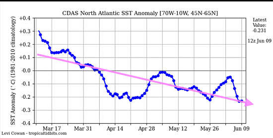
North Atlantic Trend (45N to 65 N)
There has been a steep drop into negative territory since March when it was slightly warmer than normal. Currently the North Atlantic is in negative territory at about -0.23°C.
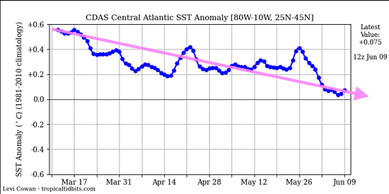
Central Atlantic Trend (25N to 45 N)
The trend in the central North Atlantic has steadily declined and currently is near the longer-term normal. The mid-latitudes started at a high anomaly of about +0.55°C in mid-March, experiencing various fluctuations before dropping sharply in late May. The latest value is +0.08°C, barely hovering above the long-term climatological baseline.
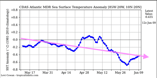
Main Development Region (10-20 N, 20W to 85W)
The overall trend of the Sea Surface Temperature (SST) anomaly in the Atlantic Main Development Region (MDR) is consistently downward. In Mid-March into April, the anomaly was slightly below neutral (about -0.2°C). A temporary warming occurred in April to early May followed by a significant drop down to -0.7°C around May 26. Currently the anomaly sits firmly in negative territory at -0.44°C as of June 9.
Hurricane Implications
Integrating the Central and Far North Atlantic data alongside the Main Development Region (MDR) data strengthens the outlook for a significanly suppressed hurricane season.
Be the first to comment!
Unmanned Ship to the Rescue – Loose Cannon
Cruisers Net publishes Loose Cannon articles with Captain Swanson’s permission in hopes that mariners with saltwater in their veins will subscribe. $7 per month or $56 for the year; you may cancel at any time.


 Forwarded this email? Subscribe here for more
When all else fails, try journalism.
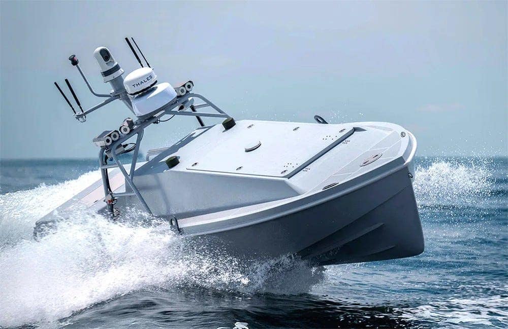
Equipped with a diesel engine, the Corsair 24 that rescued two downed U.S. airmen can travel at 35 knots with a range of more than 1,000 nautical miles and a 1,000-pound payload capacity. We have just seen the future of search and rescue at sea. “Proof of concept,” as one retired Coast Guard rescue swimmer just said.
Yesterday, a Saronic Corsair 24 “uncrewed surface vessel” rescued the two-man crew of a U.S. Army Apache helicopter downed in the Gulf of Oman, marking the first known use of a drone boat in a search-and-rescue mission.
The surface drone—aka an unmanned surface vessel—is part of the U.S. Navy’s Task Force 59, which is operating various uncrewed platforms, including the Corsair, during its Iran War deployment. When the Iranians shot down the Apache, a sister ship of the boat above was sent to the survivors’ known location.
The former commander of Task Force 59 told the Telegraph news outlet that the unit had trained for this kind of thing. “We thought it was possible, and we practiced in benign situations,” Michael Brasseur said. “But to execute in a contested environment like that, it’s a very fulfilling moment for me personally.”
The unanswered question is: How did the men get up onto the superstructure for their ride to safety? News descriptions were conclusory. The men “scrambled onto” or clambered up onto” the slab-sided vessel. As anyone who has tried to get onto anything steeper than a canoe—absent a ladder or swim platform—would testify, scrambling and clambering takes a fair bit of athleticism.
We can assume the pilots were fit, but they had probably been shaken up by their crash into the sea, and their inflatable PFDs would have made the ascension nigh impossible without first being deflated, as SAR demos have shown.
There are no obvious steps or handholds on the publicity photos distributed by
Saronic Technologies, the Austin-based manufacturer or the Corsair and two other drone boats used by the Navy. Search and rescue is just one of several warfighting missions these boats have been designed to perform.Saronic itself did not answer an email asking how the men would have been expected to board the boat.
Uninjured and highly motivated, the two men had undoubtedly been trained on how the Corsair operates and how to board one of them, according to Mario Vittone, a veteran Coast Guard rescue swimmer, now retired.
What works with uninjured military people may not succeed with wounded individuals or a retired couple who have just abandoned their sinking sailboat, but give it time. The addition of steps, handholds and robotic lifts will come.
Even at this early stage, the benefit of unmanned rescue has justified future improvements. Even without refinement, the Corsair already has greater range than most rescue helicopters and can be deployed from all manner of ships.
“They just had a lovely proof of concept, and they’ll be on cruise ships and commercial ships after that,” Vittone said. “I think all offshore searching will be done by fully autonomous drone (airborne) at around the same time. Give it a decade. Max.”
Each Corsair costs $1 to $1.2 million. According to Saronic, the Corsair is designed for multiple missions, including combat:
- Intelligence, surveillance, and reconnaissance (ISR)
- Maritime patrol
- Search-and-rescue operations
- Delivery of supplies
- Electronic warfare missions
- Force protection for larger naval vessels
- Potential deployment of both kinetic and non-kinetic payloads
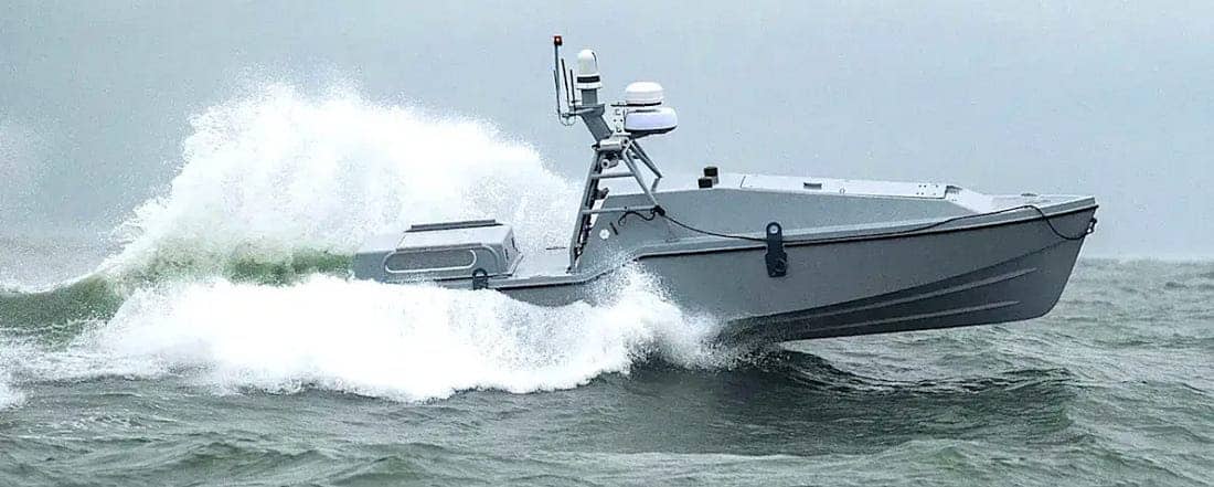
This Corsairs appears to be equipped primarily for surveillance and reconnaissance missions, with a camera turret on top of a central mast-like frame. Radar and additional sensors provide extra situational awareness. LOOSE CANNON covers hard news, technical issues and nautical history. Sometimes he tries to be funny. Subscribe for free to support the work. If you’ve been reading for a while—and you like it—consider upgrading to paid.
Be the first to comment!
Cruisers’ Net Weekly Newsletter – June 12, 2026
Cruisers’ Net Newsletter for this week has just been emailed via Constant Contact.
If you want to view the newsletter but are not signed up to receive them automatically, you can view it at https://conta.cc/4fHVdB0 or see it below.
To automatically receive our emailed Fri Weekly Newsletter and Wed Fuel Report, click:Be the first to comment!
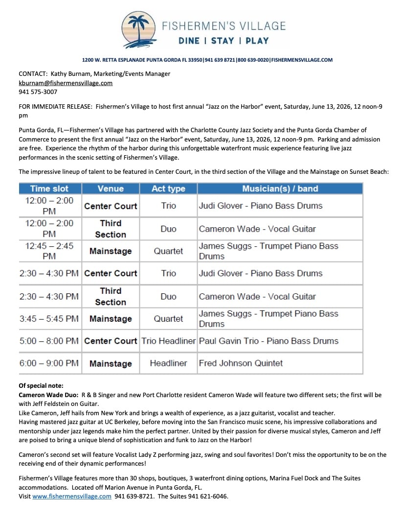
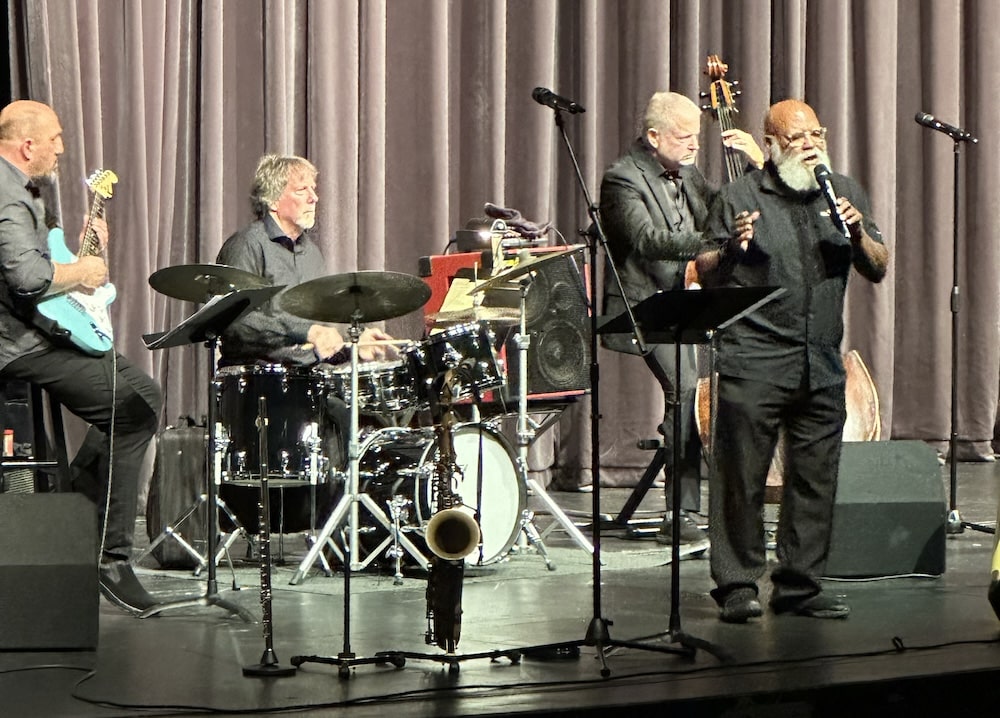
“Jazz on the Harbor” TOMORROW Saturday June 13, Fishermen’s Village, Punta Gorda, FL

There is always plenty to do around Charlotte Harbor! While berthed at Fishermen’s Village Marina, A CRUISERS NET SPONSOR, you are certain to enjoy visiting Western Florida’s beautiful Charlotte Harbor/Peace River.


Special Events & Community Relations941.639.8721
Click Here To View the Western Florida Cruisers Net Marina Directory Listing For Fishermen’s Village
Click Here To Open A Chart View Window Zoomed To the Location of Fishermen’s Village
Be the first to comment!
What’s Happening At the Sea Pines Resort (June 2026), Harbour Town Yacht Basin, SC AICW MM 565

Harbour Town Yacht Basin, A CRUISERS NET SPONSOR, is ready for your reservation with newly renovated docks, upgraded electrical service and onSpot WiFi, also a CRUISERS NET SPONSOR. And, as always, numerous activities at the Sea Pines Resort are offered for your enjoyment, as you will see in the Event Schedule below. Hilton Head Island is absolutely marvelous any time of year.

Be the first to comment!
SCDNR Conservation Education June 2026 Newsletter – SCDNR

June 2026
June is the beginning of the summer season in South Carolina with the summer solstice happening on June 21st. The summer solstice marks the longest day, or hours of sunlight during a day, that the Northern Hemisphere will receive in the year. The exact number of hours experienced will depend on the viewer’s exact location, but if you are located within South Carolina you should expect to have just over 14 hours of daylight from sunup to sundown.
We will get to observe some thrilling and exciting changes in wildlife activity this month. Aves, or birds, are active during this time of year. Along the coast, shorebirds may be seen sitting on nests. In places like Botany Bay Heritage Preserve, it may be possible to spot an American oystercatcher in the distance by scanning the dunes for its bright orange beak. Nesting areas may be marked by similarly-colored bright orange tape. Observing shorebirds from a distance, especially during nesting season, is encouraged. This time of year, species like brown pelicans, royal terns, sandwich terns, least terns, black skimmers, and American oystercatchers are settling down atop their nests. These nesting colonies will often be behind some type of barrier where they are being protected as well as monitored by scientists. To get a closer look, I would recommend a good pair of 10 x 42 binoculars or your favorite camera, or even phone with a zoom lens attached. Report your findings to iNaturalist or eBird as well to contribute valuable citizen science data! Maybe if you find a passion in reporting birds you can become one of the famous “listers” — a person who meticulously reports and seeks out different species of birds, or maybe you might find a new “lifer” — or a bird seen by you for the first time in your life.
Nature photography day is June 15th! This day was created by the North American Nature Photography association and highlights the importance of photos in telling a conservation story and in research, as well as the value of it as a nature-based activity that can be enjoyed but all people, equipment and skill level aside. Get outside and explore a new public land, with a camera of any type in hand.
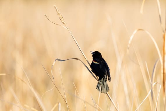
A note from Allison DeVore SCDNR Photographer and Videographer. “Every shoot brings something new, whether that’s a species I’ve never encountered or a person I’ve never met, and that’s what keeps it interesting. I love getting to tell the stories of SCDNR.” The photo of the red-winged blackbird was taken at Donnelley WMA and is one of Allison’s favorite photos that she has taken.

American Oystercatcher
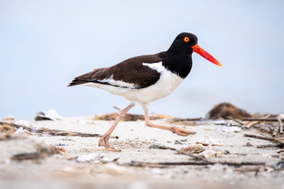 American Oystercatcher, Photo by Kaitlyn Hackathorn
The American Oystercatcher (Haematopus palliatus), found in South Carolina, is a shorebird species with a remarkable conservation success story. In 2008, the U.S. Atlantic and Gulf coast’s population estimate was 10,000 individuals. Surveys in 2023 counted 14,000 oystercatchers, an increase of 43 percent! As its name suggests, the American oystercatcher primarily feeds on oysters, mussels, clams and other marine invertebrates. Its bill, that is shaped like an oyster knife, allows it to access food sources unavailable to many other shorebirds that lack this specialized oyster opening adaptation. Habitat loss and alteration have long been major challenges for the species. American oystercatchers show strong site fidelity, often returning to the same nesting beach season after season, despite changes to those habitats over time. Conservation efforts that have contributed to the species’ recovery include habitat management for invasive species, restrictions on disturbance from domestic pets, protective buffers around nesting sites, and the creation and restoration of oyster reefs. This recovery effort has been a collaborative initiative involving state agencies, nonprofit organizations, and individuals along the Atlantic and Gulf coasts. Although the population has increased, the species still faces ongoing threats such as storms, nest disturbance, and beach erosion and loss. The story of the American oystercatcher, like that of South Carolina’s wildlife as a whole, remains an ongoing one that requires continued attention, collaboration, and support from both environmental institutions and the public.
 Looking for a fun activity geared toward kids or a school group? Learn how to make a pinhole camera!
Deveaux Bank Seabird Sanctuary
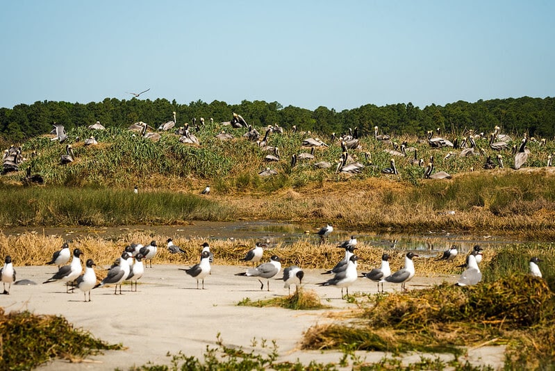
Please be aware that The S.C. Department of Natural Resources’ (SCDNR) Deveaux Bank Seabird Sanctuary is completely closed March 15-October 15 to protect coastal birds during the nesting season.
Deveaux Bank Seabird Sanctuary was established to protect significant nesting habitat of sea and shorebirds. Located at the mouth of the North Edisto River in Charleston County, Deveaux Bank Seabird Sanctuary encompasses approximately 215 acres of sandy beaches, vegetated dunes, broad marshes and intertidal shoals. The size of this sanctuary varies, and it may sometimes disappear entirely. The location of Deveaux Bank as an estuarine island was first documented in 1921, and it was documented as a seabird rookery in the 1930s. During World War II, nesting was temporarily interrupted due to the island’s use as a bombing range. Deveaux Bank is part of a dynamic system; it completely subsided in 1980 due to erosion from Hurricane David and then slowly reemerged to provide seabird nesting habitat again in 1983.
Deveaux Bank’s maritime grassland community lives on unstable sand dunes elevated above the highest flood mark. The grassland community is dominated by Russian thistle and marsh hay, which grow along with camphorweed, beach elder, beach tea and dog fennel.
Deveaux Bank supports colonies of nesting waterbirds because of its isolated nature and lack of mammalian predators. Although all species may not nest on the island each year, examples of species that have used the island include brown pelican, least tern, royal tern, black skimmer, gull-billed tern, sandwich tern, common tern, laughing gull, Wilson’s plover, American oystercatcher, willet, great egret, snowy egret, tricolored heron and white ibis.
The colonial nesting behavior of these birds makes them very susceptible to disturbance. Birds are densely packed into breeding sites during the nesting season, rendering the entire rookery susceptible to disruption or destruction. In addition, migratory and wintering shorebirds and seabirds need periods of rest and foraging free from disturbance to survive long journeys and inclement weather. The sand flats and mud flats located in the interior of the island provide feeding and loafing habitat for numerous shorebird species including red knot (federally threatened), piping plover (federally threatened), sanderling, dunlin, short-billed dowitcher, marbled godwits and many others.
In recent years, Deveaux Bank made national headlines as SCDNR biologists discovered the largest known concentration of Hudsonian whimbrels, a rare curlew species, using the site as a nocturnal roost on their spring migration. Due to its critical importance for whimbrels, as well as other migrating shorebirds, Deveaux Bank was designated as a Western Hemisphere Shorebird Reserve Network site of international importance in 2024.
 SCDNR events often require pre-registration to attend. Please click on the respective links and ensure you are signed up before attending.
Saltwater Fishing Clinics
Many dates and locations are available this month!
These clinics will teach you how to tie knots, rig your rod, how to cast, what bait to use, and what fish you can catch in saltwater! Find all dates and other events at the SCDNR Fishing Outreach Eventbrite.
Freshwater Fishing Clinics
Many dates and locations are available this month!
These clinics will teach you how to tie knots, rig your rod, how to cast, what bait to use, and what fish you can catch in freshwater! Find all dates and other events at the SCDNR Aquatic Education Eventbrite.
Ironclad Anglers Fishing Rodeo, Colonial Lake, Charleston County
Saturday, June 6th, 8:30 a.m. to 11:30 a.m.
Come join SCDNR and the City of Charleston for a hero-themed saltwater fishing rodeo at Colonial Lake. Youth 15 and under. Register here
Hikes with a Naturalist, Ashmore HP & WMA, Greenville County
Saturday, June 20th, 8:00 a.m. to 11:00 a.m.
Hikes with a Naturalist are introductory explorations into the natural world around us. These hikes will cover topics ranging from local wildlife and fishes to best hiking practices and land management. Register here
Red Snapper 101- Charleston County
Monday, June 29th, 6:00 p.m. to 8:00 p.m.
Red Snapper 101 will be taught by SCDNR staff, fishing professionals, and Shimano staff. We will go over the new updates, fish ID, and more.
The Red Snapper class goes over the new regulations, reporting system, season, fishing techniques, and fish ID. This class will teach you everything you would want to know about red snapper. Kids from ages 6 to adults are welcome, so come out to Shimano’s classroom and enjoy the class! Register here
About Us:
Conservation Education is a section within SCDNR’s Office of Education, Outreach, and Information. Our goal is to connect South Carolinians and visitors to public lands to help them live life outdoors. Our educational programs offer lessons on wildlife, fisheries, forestry, land management, watersheds, and environmental history.
Contact:
Conservation Education Section
Email: ConservationED@dnr.sc.gov
Stay Connected with SCDNR: 


Be the first to comment!
LNM: Low Country Splash, June 13, 7:30-10:00 AM, Charleston Harbor, SC AICW Sttatute Mile 465
This swim event will be north of the Waterway’s path through Charleston Harbor. More information about the event can be found at https://lowcountrysplash.com/.

Good afternoon Charleston HSC,
Please find attached the MSIB for the upcoming Lowcountry Splash. The event information is as follows:
The annual Lowcountry Splash open water swim event will take place in Charleston Harbor on Saturday, June 13, 2026, from 7:30 a.m. until 10 a.m. The 6-mile swim will start under the Wando River Bridge on Daniel Island, cross the Wando River near Hobcaw Yacht Club, and will finish at the Charleston Harbor Resort & Marina. The 2.4-mile swim will start at Hobcaw Yacht Club, continue along the Mount Pleasant side of the Wando River and finish at the Charleston Harbor Resort & Marina.
A special local regulation, established in 33 CFR 100.704, Table 1, Item No. 4, will be in effect for a moving safety zone. This safety zone will encompass all waters surrounding event participants and safety vessels extending 50-yards in front and behind, and 100-yards on either side. No one shall enter, transit, moor, anchor, or remain within the safety zone unless specifically authorized by official event patrol. Mariners can anticipate the swimmers crossing the channel on the Wando River between 7:45 a.m. and 8:45 a.m. All mariners are urged to use caution while transiting the area and should coordinate with on-scene safety boats via VHF channels 16. When hailed or signaled by on-scene safety boats, all vessels in the immediate vicinity of these racing zones shall comply with directions given.
Very respectfully,
LT Nicholas Jones
WWM Division Chief
USCG Sector Charleston
Nicholas.J.Jones@uscg.mil
O: 843-740-3184 C: 843-323-7761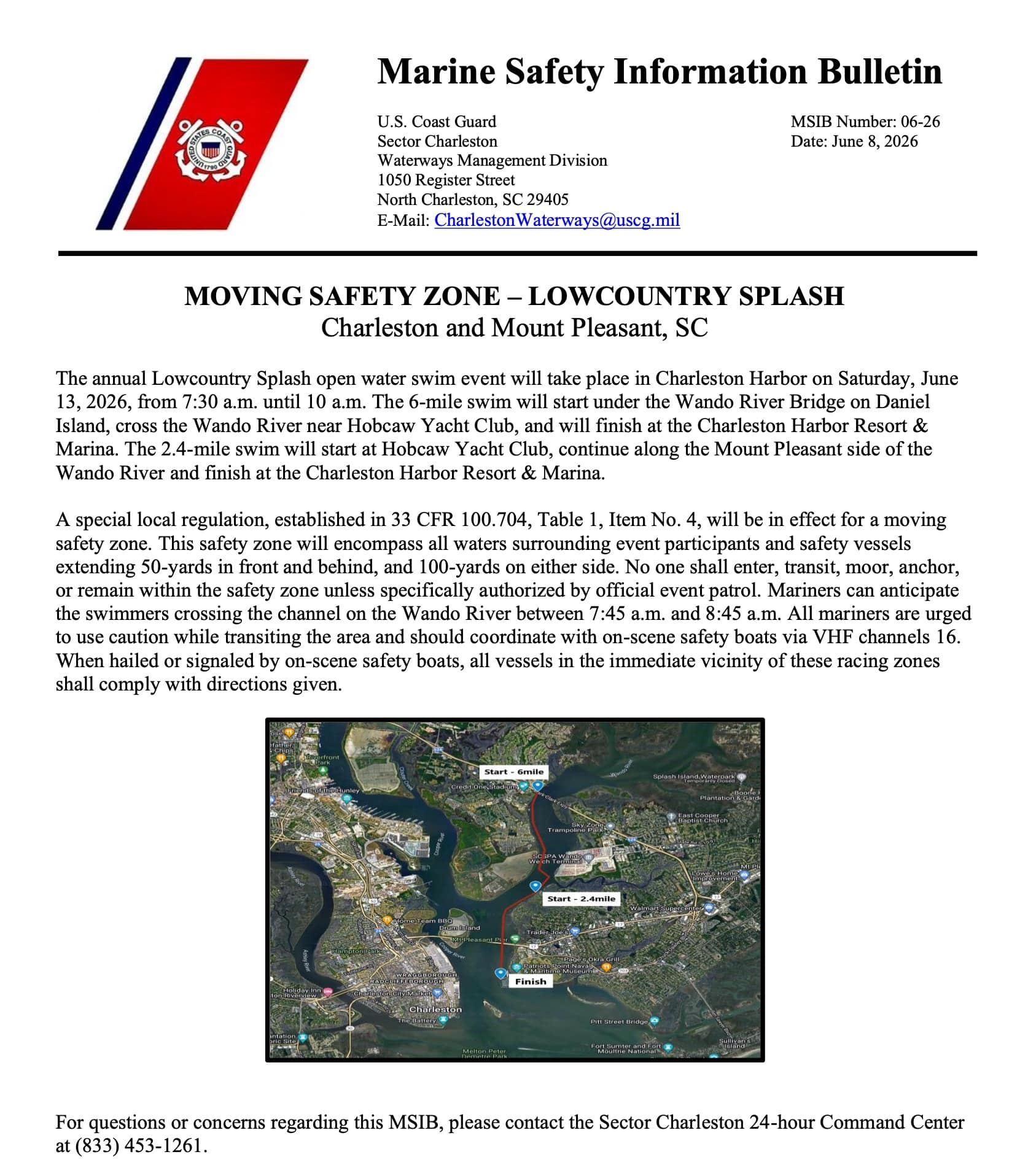
Screenshot
AREA SPONSORING MARINA
Click Here To Open A Chart View Window, Zoomed To the Location of Charleston Harbor Marina
Be the first to comment!
T Electronic Flares vs Pyrotechnic Flares: What Boaters Need to Know – Southern Boating & Yachting
Be the first to comment!


Social Media Auto Publish Powered By : XYZScripts.com
Be the first to comment!