Contributing Editor, Captain Jim Healy, shares his perspective on St. Augustine, FL, home to three SALTY SOUTHEAST CRUISERS’ NET SPONSORS and on Titusville, FL. Our thanks to Jim Healy for sharing his observations!
St. Augustine, FL: The St. Augustine light house is open to the public; the Catholic Cathedral Basilica would be of architectural interest to all; the Fort itself (Castillo de San Marcos) is wonderful, and the docents that do the historical interpretation are excellent. There are many restaurants within walking distance of the St. Augustine City Marina. We like the a1a Ale House.
Titusville, FL: Not really remarkable as a destination in itself, but the Titusville City Marina is an excellent place for boaters to stay in order to visit NASA at Cape Canaveral; the public areas and displays at Canaveral are excellent. It’s also a great place to watch a launch, if one is scheduled.
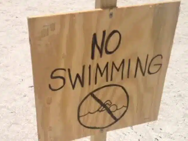
Martin County government declares local state of emergency WPTV Webteam 2:21 PM, Jun 29, 2016 5 mins ago
On a day when two Martin County beaches remain off limits to swimmers Martin County government officials have declared a local state of emergency due to toxic blue green algae in area waterways. It’s in effect for the next 7 day period. The declaration states that the algae pose a danger to health, life, property and the economic well-being of Martin County residents. It allows the government to waive procedures and formalities to ensure the health and safety of the community. Stuart & Bathtub beaches remain closed for swimming.
A SALTY SOUTHEAST CRUISERS’ NET SPONSOR, Jekyll Harbor Marina lies along the easterly banks of the AICW’s passage through Jekyll Creek, immediately south of the 65-foot fixed bridge. Our thanks to Dick Lawson for this excellent review and for the name of a good mechanic.
First time to Jekyll in a couple years. Marina under new management and services are good. The adjoining restaurant, DJ’s is closed, but being renovated by new owners and supposed to be open later this year. New town center on the island is beautiful with groceries, shopping and several restaurants – quite an upgrade from the past. It’s within walking distance, or the marina will let you use their golf cart for up to 90 minutes at a time. I required some engine work and they recommended Leo Ross, 912-266-1323, from Brunswick. He did a good and reasonable job and is also recommended. Dick Lawson
We had the pleasure of staying here Oct 16-18 while waiting on some weather to pass. This is ONE FINE MARINA. From the dock staff to the dock master PROFESSIONAL and HELPFUL. Dockage, diesel fuel and 20lb bags of ice were reasonably priced. The restaurant serves EXCELLENT food (shrimp and grits first night and fried shrimp and flounder the second night). They have a swimming pool and Jacuzzi. Clean showers. Bikes for touring the island. Or if you prefer you can get a golf cart for 90 minutes. Flash foods and Dairy Queen are within walking distance if you are looking to get a BLIZZARD. Plus they have safe and protected walking trails all the way to the resort. I am so glad for my friend Fred recommending we stop here. Call ahead and reserve your place they fill up fast. Great marina, restaurant, and friendly staff are what we all want after a day on the water.
In the 7 years we were at Jekyll Island Marina the work we hired done and observed on other people’s boats done by Leo Ross and his son was first class. As a 40 year veteran of the automotive repair business I know a good technician when I see/meet/hire one. Leo is fine Southern Gentleman of the old school where honesty and integrity are the mark of a craftsman. He also knows where to catch the nicest Georgia Shrimp in the area. Hope to get back to Jekyll one day before JIA sells it out to the rich and famous.
Skipper Dick Lawson joins others in praising Sunbury Crab Company in Brunswick, GA. Sunbury Crab Company Marina lies off the Waterway along the western shores of the Medway River, on the charted Sunbury Channel, north of Dickinson Creek.
This marina is 8 miles up the Medway River from the ICW. Plenty of deep water. Marina facility is basic but docks are good with water and power. Restaurant serving fresh local shrimp was excellent, but only open Wednesday thru Saturday nights. Ask for the owner, Elaine, and she will make sure you have a comfortable stay. Dick Lawson
Shelter Cove is located in a man-made cove on the southeastern shores of Broad Creek in Hilton Head Island near creek markers #22 and #23. Broad Creek departs the Waterway on the eastern shore of Calibogue Sound just as the Waterway turns west into the Copper River. Our thanks to Dick Lawson for this review.
Spent 4 nights here this past month. This is a beautiful and very well run marina. It is large and slips can be either close to the “action” or close to the marina office/store and showers. Regardless, one of the dock boys will show up in a golf cart to deliver you to your destination. Within walking distance there are several very nice restaurants and other shops. Transportation is also provided to the supermarket, or to the beach. Location is several miles off the ICW, up Broad Creek, and, as the name implies, it is very sheltered. Look forward to a return trip. Dick Lawson
Contributing Editor, Captain Jim Healy, shares his perspective on Fernandina, FL, home to two SALTY SOUTHEAST CRUISERS’ NET SPONSORS. Thank you Jim!
Fernandina Beach, FL: City is easy walking distance right at the foot of the docks at the Fernandina Harbor Marina. Take the tour to Fort Clinch. Visit the house where the Pippi Longstocking movie was filmed. Visit Billy Burbank’s trawl net factory; they make shrimp nets; they’re open to the public for tours, and it’s a very interesting afternoon.
Explorer Chartbooks, A SALTY SOUTHEAST CRUISERS’ NET PARTNER, has long been the standard navigational supplement for enjoyable, informative, and safe cruising through the beautiful Bahamian waters and island visits.
Bahamas Chatter: West end bound West end bound Posted: 25 Jun 2016 06:07 PM PDT Getting geared up for a crossing to west end from east coast fla – Jupiter/ Stuart/ wpb tbd possibly as early as the first week of July to mid month to be in Hopetown by the last week of July. Looking for any buddy boats and or weather links/ recommendations. 41′ american tug 4’10” draft cruising 10+ knots thanks Hooty Hoo II
Contributing Editor, Captain Jim Healy, shares his perspective on Charleston and Beaufort, SC and Savannah, GA where several SALTY SOUTHEAST CRUISERS’ NET SPONSORs are located. Thank you Jim!
Charleston, SC and Savannah, GA: magnificent old southern cities with many points-of-interest and fine restaurants; our strategy is to take a tour bus around the city. Look for a tour company that has same-day on-and-off privileges. (We do this every time we arrive somewhere we’ve not been before, including Canada). We take the entire tour circuit first, then go back to places that we think we’d like to know more about. At Charleston, start at the Welcome Center. Or, take the tour boat to Fort Sumter; nice aquarium near the Ft. Sumter ferry docks. In Charleston, there is a water taxi from the Charleston Maritime Center that goes back and forth to Patriot Point, which is where the USS Yorktown is located. In Savannah, there is a nice stage theater within walking distance of the downtown waterfront (http://www.savannahtheatre.com). The Savannah waterfront is very interesting, with a large riverwalk, wonderful park overlooking the River, and large shipping and commercial traffic as well as every kind of small-boat and pleasure craft. There are several architecture tours in both cities, and both have lots of weekly and seasonal activity for visitors. From Savannah (there are marina options in downtown Savannah on the Savannah River or at Thunderbolt and Isle of Hope), boaters can also visit Tybee Island (light house and Fort Pulaski).
Beaufort, SC: from the Beaufort Downtown Marina, take a carriage tour through the historic ante-bellum homes in the area. The downtown is friendly with many shoppes and good restaurant options.
Our sincere thanks to Captain Greg Allard for this excellent report and photos of the Okeechobee Waterway. Greg is an experienced cruiser and his observations and advice are definitely to be trusted and heeded.
Okeechobee Update – June 24, 1016
We just finished crossing the Okeechobee waterway from east to west. Some observations:
1) Obstruction report at MM34: On January 12, 2016 the Cruisers Net contained a report of a vessel which hit an object and sustained damage in the vicinity of MM 34 on the St. Lucie Canal.
On June 22, 2016, while we were underway we observed the scene below, at approximately MM34:
This bird was perched on the limb of a tree, on the south side of the waterway. The water was very murky, so we could not see any other parts of the tree or limb to be able to tell how far it extended into the waterway. The bird is approximately 30’+ from shore.
I hit the MOB button, and recorded the location as we passed: 27 degrees 00.8582’N; 080 degrees, 32.8102′ W.
In re-reading the report about the damaged vessel from January 12th, it appears that the vessel was “along the side of the canal which is the starboard side coming East from Port Mayaca,”“which would have put it in approximately this location. Of course we can’t be certain that this was the earlier reported obstruction.
This type of hazard is not unusual along this portion of the St. Lucie Canal. Just a mile further west, we took this photo:
On both sides of the canal, there are stands of trees, including some tall casuarinas on the right side. If one of them fell into the canal, it could easily become a hazard. The lesson here is to “stay in the middle”. That won’t protect you from free-floating logs or pilings, but it will minimize the risk of contacting fallen trees.
2) Lake Okeechobee water levels: The water levels in the lake have been high, due to heavy rains. Most cruisers use “Route 1” to cross (as opposed to Route 2, the southern rim route). This link takes you to the Corp of Engineers site, showing you the current depths for each route:
According to the Corps, the shallowest part of Route 1 is in the SW corner of the lake, from Clewiston out to where the channel stops its zig-zags. Follow the markers carefully, and don’t drift off. When we crossed on June 22, the level was over 8.8’.
It’s important to try to cross the lake as early as possible in the morning, before any strong winds develop, especially if the winds come from the north/northeast, or east. Where the water is only 8’ deep, if winds cause waves in the lake 2-4’ in height near the SW corner of the lake, a boat with a 5’ draft may start to bottom out in those conditions. The bottom there is rock, not sand.
3) Algae conditions:
Due to the heavy rains, there are severe algae blooms in the St Lucie canal, lower St. Lucie River, and the lake. We saw none on the Caloosahatchee River side. The algae is kelly green in color. Here’s what it looks like:
According to local news reports, samples have been sent to
Florida’s health lab for testing, so as of the time of this report it is unknown whether it will be considered toxic or not. We observed no cooling issues with our engines as we passed through these patches. It is thin and “whispy” and did not accumulate at all in the engine strainer baskets.
Favorite places to stay overnight:
1) To position yourself for an early morning Okeechobee crossing, going west to east:
a) Moore Haven docks (just before the lock). $1.00 a foot; electric available.
b) Roland Martin’s Marina, in Clewiston. Probably the best layover place; right on the edge of the lake. The outdoor bar is terrific: it reminds us of the bar scene in the first Star Wars movie.
When we stayed there in March on the way east, the small lock at Clewiston was actually in operation (the first time we have ever seen that.) Our 65’ LOA boat barely fit into the lock. On our most recent return trip, the lock was fully open, not in operation, and allowed full pass-through to the marina. The Clewiston lock is not operated by the Corps of Engineers – it is private, and the people who run it are well intentioned, friendly amateurs. Just because they tell you to do something, it doesn’t mean they know what they are talking about. They put about 20 bass boats into the chamber with us, and they were hanging all over us, banging into us, and cutting us off as we entered the chamber; it was bedlam.
Roland Martin’s is still the best place to stay on a west to east trip. The dockmaster Sam is excellent. Call for a reservation.
2) To position yourself for an east to west crossing of the lake in the morning:
a) Indiantown Marina: A true old fashioned time-warp. They have limited slip space, but at $1.00 a foot, it is a bargain. It’s about 9.9 Statute Miles from the Port Mayaca lock, where you would begin to cross the lake.
b) If Indiantown can’t take you, the River Forest marina, just 1/2 mile west of the St. Lucie lock, is a good alternative, at $1.35 a foot. It will take you longer to get to the eastern edge of the lake in the morning, but there aren’t any other choices.
4) Ortona Lock Restrictions:
The Ortona lock is undergoing repairs, and there are restricted openings which have been reported on the Cruisers Net.
Note that the restricted openings do not apply on weekends, when the lock will open on demand from 7:00 AM to 4:30 PM.
On our recent trip across the waterway from east to west, we stayed at the River Forest location in Moore Haven, just 1/4 mile east of the Ortona lock. It’s perfectly positioned to allow us to arrive at the Ortona lock in time for the 7:00-7:30 limited opening. We did hear the lockmaster, on the VHF, allowing a boat to lock through at a time other than the restricted windows, so it does not hurt to ask. It depends on whether construction is actually going on.
Corp of Engineers Contact:
The day before we begin any Okeechobee crossing, we call the local Corp of Engineers office directly (they are in Clewiston), to be sure there aren’t any lock shutdowns or bridge problems. They are always very helpful.
Many of our cruising friends would never consider using the Okeechobee. We enjoy the trip. It’s much shorter than going down through the Keys and then heading north, up through the endless and tiresome Florida Bay, which can be loaded with crab traps. It is also easier to run the waterway in bad weather. It presents a fascinating slice of old time Florida. Scenes like this sunrise make it worthwhile:
Longboat Key Club Moorings, A SALTY SOUTHEAST CRUISERS’ NET SPONSOR, guards the western shores of Sarasota Bay, north of the city of Sarasota, and south of Longboat Pass. With the advent of mooring fields in Florida, you might mistake this marina as just another set of mooring balls. But, believe you me, this is one gorgeous marina. Anna’s comments are typical for this excellent facility and we are glad they stumbled upon it!
My husband and I stayed here last week while on vacation….we actually stumbled upon it. What a beautiful resort. We were pleasantly greeted by Pete the dockhand. He was very helpful. We were very impressed by the amenities, pool (pool towels are given at office) and very nice showers, bicycles for loan, Publix within walking distance. Harbor masters store and staff was awesome. We didn’t make it to Portofinos but will visit it next time. We will definitely be back. Anna
LBK Moorings is our home port. It is beautiful, very well run, and has everything any visiting boat would need….. but no mooring balls. You may be thinking of Marina Jack across Sarasota Bay.
Just an FYI, transients must have assigned marina slips. No anchoring in the bay and dinghy in. The Longboat Key Club and Marina are private, members and guests only.


Be the first to comment!