A new divers-down buoy was just introduced in March of this year, see /?p=147183.
FWC encourages recognition and use of the divers-down flags/buoys
Whether diving in Pensacola, scalloping in the Big Bend, lobstering in the Florida Keys or seeing the sights below the water’s surface in one of the many rivers in the Sunshine State, the Florida Fish and Wildlife Conservation Commission (FWC) wants to remind divers to use a divers-down flag or buoy whenever they are snorkeling or scuba diving.
The divers-down symbol is rectangular or square and red in color with a white diagonal stripe. A divers-down flag displayed on a boat must be at least 20 inches by 24 inches and displayed at a high point where it can be observed from 360 degrees around the vessel. A buoy may not be used or displayed from a vessel. A divers-down flag or buoy, displayed from the water, must be at least 12 inches by 12 inches. A flag must have a wire or other stiffener to hold it open and a buoy can be three- or four-sided.
All divers must prominently display a divers-down flag or buoy in the area in which the diving occurs.
`Proper use and understanding of what a divers-down symbol means is critical,’ said Lt. Seth Wagner with the FWC’s Boating and Waterways Section. `It is meant to alert boaters to the presence of people under the water’s surface and to give them plenty of room.’
All vessels must make reasonable effort to stay at least 100 feet away from a divers-down flag or buoy within a river, inlet or channel. In open waters, vessels must make reasonable effort to stay 300 feet away. For safety, divers should stay within those same distances of their displayed flag or buoy. A vessel that approaches closer must be fully off plane and at idle speed.
`Divers share the responsibility of boating safety with the boat operators,’ Wagner said. `Diving without the divers-down symbol displayed or using it for reasons other than to inform of the presence of divers is unlawful.’
The flag or buoy should only be displayed when divers are ready to enter the water or are in the water. When divers or snorkelers exit the water, it must be taken down.
More information on divers-down flag requirements is available online at MyFWC.com/Boating by clicking on `Boating Regulations.’
Key West Bight City Marina occupies a good portion of the rear (southeasterly shores) of Key West Bight.
We have stayed at Key West Bight Marina for three years in a row. Each we time we stay for about 5 or 6 months. The staff is great. The marina has great water and is close to downtown. We highly recommend this place. Radler
“No charge” – sweet words to any boater! These guys are building a solid reputation, one boater at a time. Bravo Burkey Marine Group!
We feel the same way! These big diesel guys helped us over the phone telling us what to look for and once we located the problem they talked us through the repair at no charge. (After hours) We are fans! Ted Davis
Recently used a repair firm to handle an engine shut down situation which was quite scary. The mechanics from bigdieselmarine.com aka Burkey \Marine Group came out right away “as stated several times elsewhere” they handled our big problem easily with minimal cost and lost time! We are passing it on as we should! The number for Big Diesel direct is 772-215-7663 Tim Daily
We arrived in Stuart Florida with engine problems at Sailfish Marina and were told to call Greg Burkey Marine group. After contacting Burkey Marine aka Big Diesel Marine we were on our way soon! Happy to pass on the number to our community Burkey Marine group at 772-215-7663 burkeymarinegroup@gmail I feel safe recommending them!
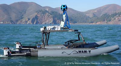
You will think you are seeing things when this unmanned inflatable passes you. Wonder how it will deal with jet skis?
Google Maps Goes Coastal with Unmanned Boat
A new high-tech unmanned vessel, launched with the help of Google, will use innovative technologies from the boatbuilding and mapping fields to map shorelines and raise awareness of the impacts of global sea level rise.
Originally designed to be worn by backpackers, Google’s proprietary Street View Trekker camera system was provided on loan to the San Francisco Baykeeper organization, allowing them to create bay-level maps. It plans to use the imagery collected’”nearly 500 miles of coastline ranging from San Jose to Antioch, California’”on its website and for educational purposes. It will also help illustrate the threats posed by global sea level change to critical wetlands.
Electric motor developer Torqeedo said it was chosen to power the craft as clean, powerful and efficient propulsion was a high priority.
“It’s a Google Boat,” said staff scientist for the San Francisco Baykeeper organization, Ian Wren. The small, remote-controlled catamaran, a Wave Adapted Modular Vehicle (WAM-V) designed by Marine Advanced Research, features a modified hull design that flexes to adjust to the water’s surface and provides ultimate stability. Baykeeper’s WAM-V sports twin Torqeedo Cruise 4kW electric outboard motors rigged with Power 26-104 lithium batteries. The boat is able to run for hours with a nearly zero environmental footprint, thanks to onboard traditional and solar charging capabilities.
“A lot of people know about sea level rise,” said Sejal Choksi, an environmental lawyer and Baykeeper’s interim director. “We are hoping these images will really bring the reality home to the public, that they will look at pictures of places they know and say, ‘Oh my gosh, this is going to be underwater.'”
The Google Trekker, WAM-V and Torqeedo technology has also recently completed a mapping project of American Samoa. ‘¢ Google ‘¢ Ian Wren ‘¢ Sejal Choksi
We all know that California is sinking due to plate techtonics so do they really expect to sell this rising sea level due to climate change to non-Californians?
The conflict between All Aboard Florida RR system and the Florida waterways continues to be a source of discord for spokespersons of both industries. Much discussion has followed the introduction of the controversial plan to increase the daily number of trains crossing primary water routes. Is this article just more political promises? It’s hard to imagine how increased RR bridge activity will not impact the flow of water traffic.
Florida officials vow rail plan won’t hurt marine industry Posted on July 29th, 2015 Greg Stuart (left), director of the Broward Metropolitan Planning Organization, U.S. Rep. Lois Frankel, D-Fla., and Marine Industries Association of South Florida executive director Phil Purcell are shown at the meeting. Greg Stuart (left), executive director of the Broward Metropolitan Planning Organization, U.S. Rep. Lois Frankel, D-Fla., and Marine Industries Association of South Florida executive director Phil Purcell are shown at the meeting.
U.S. Rep. Lois Frankel, D-Fla., and Broward Metropolitan Planning Organization director Greg Stuart vowed that they will not put the marine industry at risk at a meeting last week with stakeholders in All Aboard Florida.
Representatives of the Marine Industries Association of South Florida, the Coast Guard, the Broward County Commission, the Greater Fort Lauderdale Alliance, All Aboard Florida and Florida East Coast Industries also attended the meeting. It was held to get an update on the railroad test regulations being implemented at the FEC rail bridge over the New River.
Greg Stuart, executive director of the Broward Metropolitan Planning Organization, promised that his organization will not allow for the degradation of the bridge and the capacity of the marine facilities west of it.
`We recognize the need to improve it if we want to add more,’ he told attendees.
Frankel commended the Coast Guard for its efforts and vowed to stay committed to the marine industry and finding a solution. `I’m optimistic we can do it,’ she said.
The test regulations in place require that the bridge not be closed more than a combined 60 minutes during any 120-minute time period. If the test regulations are successful, the Coast Guard has indicated they will become permanent.
Coast Guard Bridge Administrator Barry Dragon said communication has been the biggest problem in the past and that the regulations, which require various means of communication, have helped the service get a handle on it.
A review of Coast Guard logs shows that since the test regulations began, the average time the bridge has been down is 1 hour and 45 minutes during a 12-hour period for 17 minutes each time.
Representatives from All Aboard Florida and Florida East Coast Industries, the parent company of All Aboard Florida, said their goal is predictability and communication. Starting in 2017, they estimate that AAF’s 32 trains will add 12 minutes to every hour that the rail bridge is closed between 6 a.m. and 9 p.m., totaling an additional three hours during the day, and that they will implement a website and/or an app that will communicate the times of the closings.
`We both want to grow and grow successfully,’ said Jose Gonzalez, senior vice president of Florida East Coast Industries.
They also discussed short- and long-term initiatives to move freight west to U.S. 27. The Florida East Coast Industries said eight of the 14 trains that run through the county, mostly at night, could eventually be diverted to CSX tracks. The MIASF pointed out that this would help car traffic, but the trains still would cross the New River at another point.
All agreed that during the next five to seven years growth in Florida, combined with freight and additional commuters on the FEC corridor, will require a second, higher bridge over the New River to elevate commuter trains, ensure predictability and protect the marine industry. Both the MPO and Frankel committed to finding funds for the bridge.
Share:
Comments from Cruisers (1)
Rick Emerson- July 31, 2015 - 2:00 pm
I believe Col. Sherman T. Potter of M*A*S*H said it best: “Bullpucky!” Yet again Florida shows its disregard for boaters.
Because of The Spirit of South Carolina, built by hundreds of volunteers and based in Charleston, tall ships are of particular interest to Charlestonians. One will not be surprised to learn of an invitation to visit Charleston being extended to Oliver Hazard Perry in the near future.
Maiden Voyage: SSV Oliver Hazard Perry Sets Sail NEWPORT, RI (July 17, 2015) ‘“ Rhode Island’s 200-foot Official Sailing Education Vessel SSV Oliver Hazard Perry sailed for the first time yesterday in Narragansett Bay after she left the Hinckley Boat Yard in Portsmouth, R.I. to begin a journey up the coast to join the Tall Ships Portland 2015 festival. Anyone on or near East Bay Passage between seven and eight a.m. saw a truly amazing spectacle when four of the ship’s 20 sails were unfurled, one-by-one as crew members climbed aloft to set free the lines that secured them to the yards.
Rhode Island’s 200-foot Official Sailing Education Vessel SSV Oliver Hazard Perry sailed for the first time yesterday in Narragansett Bay. (All photos credit Onne van der Wal)
Rhode Island’s 200-foot Official Sailing Education Vessel SSV Oliver Hazard Perry sailed for the first time yesterday in Narragansett Bay. (All photos credit Onne van der Wal) Available for download in high resolution by clicking the photo
`This is a huge milestone,’ said Jess Wurzbacher, Executive Director of the non-profit Oliver Hazard Perry Rhode Island (OHPRI), `over the past seven years all of her movements have been under the control of tugs. The wind was blowing 12-15 knots out of the north to make it a nice downwind run out of the Bay, so it was great to watch the sails harness some of that power ‘“ it is what we have all been waiting to see for years.’
SSV Oliver Hazard Perry is the first ocean-going full-rigged ship built in America in over a century. She also is this country’s largest privately-funded, actively sailing Tall Ship, one of only 75 Tall Ships in the world designated by Sail Training International as Class A.
On July 3rd SSV Oliver Hazard Perry was dockside at the Newport Shipyard for the `Homeport Rhode Island’ gala. The annual fundraising event celebrated the unprecedented $16 million economic development project, which has supported hundreds of jobs in the Rhode Island marine industry. It raised $122,000 while also honoring the non-profit organization’s Board Chairman Bart Dunbar for his unfailing devotion to OHPRI’s Education-at-Sea mission.
cid:image003.jpg@01D0C0A0.EEAE3900 Supporters gathered at Newport Shipyard for Oliver Hazard Perry Rhode Island’s `Homeport Rhode Island’ Gala on Friday, July 3. (All photos credit Al Weems, alweemsphoto.com) Available for download in high resolution by clicking the photo
With orange being the color theme, most of the 450 guests were decked out in their orange best. The signature drink, the `Dunbar Fizz,’ also was orange, and wait staff from Blackstone Catering sported orange bow ties. Cocktail hour included tours of the ship, passed hors d’oeuvres and offerings from a fresh seafood bar, while dinner was served under a giant tent with orange globe lights.
At the event, Dunbar acknowledged all of OHPRI’s supporters, and especially Admiral Tom Weschler, OHPRI’s Chairman Emeritus, who was in attendance, with helping the organization realize its dreams. `We are far from finished with fundraising,’ said Dunbar, explaining that the focus will soon turn to the ship’s Education at Sea programs, `but it is a huge milestone to have the ship completed and going through its final inspections and preparations for accommodating students of all ages.’
Rhode Island’s Tall Ship will serve the youth from all states with its Education at Sea programs. It is the first ocean-going full-rigged ship built in America in over a century.
This article comes to us from our friends at BoatNation.com.
Surviving a Close Encounter with a Shark The best way to avoid a shark attack is to simply stay out of the ocean. On the other hand, it’s difficult to resist a dip in the water on a warm day. If you do decide to go for a swim, keep the following tips in mind. You may not be able to prevent an attack, but you may be able to minimize your injuries. Believe it or not, unprovoked shark attacks on humans are rare with an average of around 75 per year, resulting in about 10 deaths worldwide. You have a greater chance of dying from a bee sting or being hit by lightning.
Avoid being in the water from sunset to sunrise. This is when sharks are most active.
Avoid being in the water near where people are fishing.
Also avoid swimming during or after storms, which can make the water cloudy and churn up the fish that sharks feed on. They won’t be able to tell if you’re human or prey. The same applies to river mouths – where the water can be muddy.
Avoid peeing in the water. It’s not just blood that they are attracted to. Sharks are attracted to urine. A lot of cases of surfers and divers, that have been attacked by sharks, have been preceded by the need to urinate. Another good idea if you need to pee in the water, wetsuit or not, is to let it go in the white water. Action from the waves gives it a better mix, and it’s not as likely to attract the sharks nose
Do not swim if you have a bleeding cut or abrasion. Sharks sense blood and are attracted to even a tiny amount in the water. Sorry ladies, stay out of the water if you are having your period.
Don’t take your eyes off the shark. Don’t turn your back on the shark as you move. Remember, it’s important to keep the shark in view. Make eye contact when possible and try to keep your eyes on the shark at all times. Sharks like to attack from behind. Keeping your eyes on the shark may help to avoid an attack. In open water, get back-to-back with another swimmer or diver so that you can see, and defend against, an attack from any direction. If possible, Slowly back up against a reef, piling, or rock outcropping – any solid obstruction ‘“ so that the shark can’t circle around behind you. This way you only have to defend attacks in front of you.
Stay in a group. People on their own are more likely to be attacked than large groups. Don’t wander too far from the shoreline.The further you are from the shore, the further you are from help. Choose your attire carefully. Avoid wearing shiny jewellery, because the reflected light resembles the shimmer of fish scales. Also don’t wear brightly-coloured or patterned clothing, because sharks see contrast particularly well. Special striped wetsuits which look like poisonous, black and white banded sea snakes are being tested which warn a shark that a diver or surfer isn’t safe to eat.
Stay still and remain calm if you spot a shark. Most sharks are just curious and will leave on their own. Attacks are very rare.
If you are attacked, fight back. If you are targeted by a shark, the general rule is, do whatever it takes to get away – but do it calmly. Try to fight back and startle it. The best place to hit is its nose. Also try to claw at its eyes and grab its gills, two of the most sensitive areas on a shark. Make sure you’re able to defend your front and sides and use a weapon like a surf board if possible, don’t use your hands. If you are bitten, stop the bleeding and get help as soon as possible.
Special thanks to George H. Burgess, senior biologist in Ichthyology at the Florida Museum of Natural History
Stay Safe and Happy Boating! Ashley and the Crew at BoatNation.com
BoatNation.com was founded to offer affordable advertising options specifically for promoting boating businesses as well as private sellers. BoatNation.com is not only a comprehensive Boating Resource Directory, it also provides a cost effective venue for buying and selling new and used boating equipment, waterfront real estate, boats and much more.
According to this article from Trade Only Today, boats cruising to Cuba would find refueling difficult and only the basic facilities at existing marinas. Still for those of you with the craving for new waters and new ports, the prospect of taking your boat to Cuba must be absolutely mouth-watering.
U.S.-Cuban ties could be boon to marine industry Posted on July 20th, 2015
After 54 years of animosity, the United States and Cuba formally restored diplomatic ties.
This morning, the United States opened an embassy in Havana and Cuba opened an embassy in Washington, D.C.
In truth, both countries had for years already been running robust interest sections in both capitals. Today, however, both of those missions were upgraded.
This afternoon, the Cuban flag will be raised on the grounds of the Cuban Embassy in Washington for the first time since 1961, according to National Public Radio.
U.S. Secretary of State John Kerry will travel to Havana to raise the American flag at the U.S. Embassy there at a later date.
Starting today, U.S. officials said, the Cuban government will pull back some of the tight cordon of security that had surrounded America’s diplomatic mission in Havana and no longer will record the names of Cubans entering the building, according to CNN.
The Cuban and American heads of their respective interest sections will became charges d’affaires until ambassadors are named.
`A new stage will begin, long and complex, on the road toward normalization,’ Cuban President Raul Castro said in a televised address last week to the Cuban people. `Which will require the will to find solutions to the problems that have accumulated over more than five decades and hurt ties between our nations and peoples.’
The National Marine Manufacturers Association recently announced a third and final exploratory trip to Cuba, set for December.
Cuba has 11 million residents, and if it were a U.S. state it would rank seventh in population, according to the NMMA. Cuba has 1,400 miles of coastline similar to the Florida Keys ‘” if the Cuban Keys were superimposed on the Atlantic Seaboard, they would stretch from Miami to New York.
The NMMA said Cuba also has more than 100 freshwater lakes suitable for boating. Built by the Soviets from the 1960s through the 1980s, the 3- to 5-mile lakes irrigate rice fields and teem with largemouth bass. That means 95 percent of Cubans live within five miles of boating waters.
In December, NMMA export director Julie Balzano told Trade Only about the association’s second visit to the Caribbean’s largest island.
`If and when U.S. boaters would be allowed to go to Cuba by boat, I think probably there is enough infrastructure in place at the moment, though I think it would be basic for American boaters visiting Cuba,’ she told Trade Only at the time. `I think they struggle a bit with fueling stations in marinas,’ for example.
`Cuba, just the country itself, is struggling with infrastructure,’ she said. `If tourism grows, they’re going to struggle with hotel occupancy and eateries. It’s still a challenge to get basic items in Cuba.’
The island, though, has a lot to offer boaters in terms of its beauty. `It’s lush and green and mountainous, and the waters are crystal-blue,’ Balzano said.


Be the first to comment!