|
Your Parks, Your Impact:
A Message From Our Board President |
|
| A new year is upon us! For our team here at Outer Banks Forever, January is a time to celebrate the impact you helped us make in 2024, as well as a time to look ahead and plan our next round of projects in our Outer Banks National Parks. Let’s celebrate together a few of the projects your generosity made possible in 2024: |
|
|
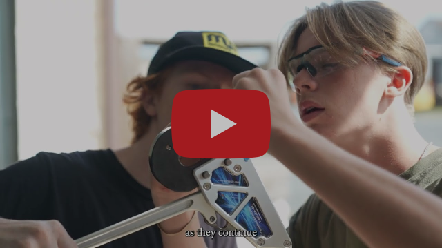
| We supported the production of a new video series following the progress of First Flight High School students who are a part of the Wright Flight Academy. These students are currently working to build an FAA-certified airplane in a workshop on the grounds of Wright Brothers National Memorial, the site of the first heavier-than-air, powered flight. The video series is available on our YouTube channel, so don’t miss it! At Fort Raleigh National Historic Site, the newly enhanced Freedom Trail was unveiled this past spring. This expanded educational experience, featuring artwork by Sonja Griffin Evans, life-sized silhouettes, and new educational signs, helps tell the story of the freedom seekers who risked everything to create a safe haven for themselves and their loved ones on Roanoke Island beginning in 1862. This past fall, the new Cape Hatteras Lighthouse Pathway opened for public use! This multiuse pathway connects Route 12 to Old Lighthouse Beach and the Cape Hatteras Lighthouse. The final part of this project – expected to be completed this year – is a new family-friendly, accessible restroom and shower facility at the Old Lighthouse Beach access. Recognized as one of the best beaches in the United States for surfing, kitesurfing, windsurfing, fishing and many other watersports, these upgrades were way overdue and thankfully in place by the next time you visit.The more people and businesses who support Outer Banks Forever, the better Cape Hatteras National Seashore, Fort Raleigh National Historic Site, and Wright Brothers National Memorial can be on a consistent basis. At REAL Watersports, Watermen’s Retreat, and Watermen’s Bar & Grill, the companies I co-founded here on the Outer Banks, we make sure that what we roll out to our customers is better every year than the previous year. And that’s what we want to see happen with our Outer Banks National Parks. Every time a family comes back, we want them to say, “Wow, this wasn’t here two years ago when we were here. This is awesome!” Outer Banks Forever can – and does – make that happen with the help of people like you and businesses like yours. As we begin a new year of work together, we’re also seeking our next passionate Director to lead us in our mission to protect and enhance our Outer Banks National Parks. We will be forever grateful to Jessica Barnes, our founding Director, for her incredible leadership these past six years. Until our next director is hired, feel free to reach out to Nicole Erickson, our Interim Director & Development Manager with any questions or needs you have. I am confident that Outer Banks Forever is in great hands with our whole team – Nicole, Rachael Graf, and our dedicated Advisory Board who bring with them an incredible and varied list of talents and backgrounds. We have an exciting year ahead full of new opportunities! We look forward to partnering with you and updating you often on the important work we do together.
Sincerely,
Trip Forman
Co-Founder, REAL Watersports, Watermen’s Retreat, Watermen’s Bar & Grill
President, Outer Banks Forever Advisory Board |
|
| As you may have heard recently, the Bodie Island Double Keeper’s Quarters (Visitor Center) was impacted by a fire in the afternoon of Tuesday, January 7. Fortunately, the Outer Banks Forever store staff and park staff who were in the building at the time made it out safely, and the fire was extinguished without any reported injuries. |
|
|
| Due to the interior damage the Double Keeper’s Quarters received from the fire, the building is closed indefinitely. The investigation into the cause of the fire, clean up, and repairs are ongoing. During this time, the park’s outdoor areas remain open for visiting. The annual Bodie Island Lighthouse climbing season, which typically begins near the end of April, will not be impacted by the current closure of the Double Keeper’s Quarters. |
|
We’d like to express our gratitude to the Nags Head Fire Department, the Roanoke Island Volunteer Fire Department, the Kill Devil Hills Fire Department, the Colington Fire Department, and Dare County Emergency Medical Services, who all responded to the fire.
“Cape Hatteras National Seashore is grateful for the timely response to this afternoon’s fire by multiple local fire departments,” stated David Hallac, Superintendent of our Outer Banks national parks, in a press release. “Their efforts minimized damages to this historic structure.” |
|
Our mission is to help protect and enhance our Outer Banks national parks, now and forever. That includes supporting our parks when they face unexpected challenges like this one.
If you’d like to support restoration efforts at the historic Bodie Island Double Keeper’s Quarters, make your gift today to our Parks Forever Fund. This fund allows us to pool funds from each of you, as well as our local business partners, to help our parks adapt to immediate needs as they arise and create a sustainable way to address longer-term needs.
We know how much you love the Outer Banks, and how many of you have a special place in your heart for Bodie Island in particular. To learn more about our Parks Forever Fund and to make your gift today, click the button below. |
|
The Wright Flight Academy:
Leaders and Mentors |
|
 | This content is brought to you by our partners at the National Park Service.
In the sixth installment of the Wright Flight Academy, students are kicking of the second year of the build with the class seniors taking the lead! Over the next year, these students will be completing the build of their very own, two person “flying machine” on the very grounds where brothers Wilbur and Orville Wright achieved their world-changing first flight on December 17, 1903! We’re proud to support this program by sponsoring this video series created by Rayolight Productions. As videos are made available, we’ll be adding them to our YouTube channel, sharing them on Facebook, and including them in our monthly e-newsletters. |
|
Meet Your Ranger: Taylor Evans |
|
| Our Meet Your Ranger series introduces you to the many amazing people who support our Outer Banks national parks every day! This month, we’re pleased to introduce you to Taylor Evans, Partnerships and Programs Coordinator for our Outer Banks national parks! No two days are alike for Taylor as she meets with partners in the field, visits park staff, reviews and drafts agreements, and explores potential partnership opportunities in order to better connect our community to our three national parks. |
|
|
| In her free time, Taylor enjoys trying new things, whether that’s reading a new book, trying a new restaurant, or experiencing a new part of the beach! |
|
Outer Banks National Parks Field Trips |
|
| If you’re an educator, we want to help you get your students to Cape Hatteras National Seashore, Fort Raleigh National Historic Site, and Wright Brothers National Memorial for field trips! Thanks to an Open OutDoors For Kids grant from the National Park Foundation, we are able to reimburse transportation costs (up to $1,000) for field trips for your students in kindergarten through 12th grade. We are thrilled to be able to provide this opportunity to get your students out of the classroom to experience the unique history, culture, and environment our Outer Banks national parks preserve! |
|
|
| (And this is a great way for your students to learn about and explore our Outer Banks national parks in the winter!)Educators who are interested in participating in this program and scheduling field trips to our Outer Banks national parks can email Rachael Graf, Community Engagement Coordinator at Outer Banks Forever, for more information: rachaelgraf@obxforever.org. |
|
|
| |
|












Be the first to comment!