Upcoming Florida Marine Exhibitor and Vendor Events, Treasure Coast, FL
Seafood Festival, Boat Show and Flea Market – what more could you want?
Click here for Featured Upcoming Florida Marine Exhibitor and Vendor Events
Seafood Festival, Boat Show and Flea Market – what more could you want?
Click here for Featured Upcoming Florida Marine Exhibitor and Vendor Events
Once again, Jim Healy graciously imparts his experience in response to a Looper’s questions on AGLCA’s Forum with an excellent description of the Okeechobee Waterway. Jim is a true cruiser helping cruisers! Thank you Jim.
1) How many days should we anticipate to cross Florida going west at 9 knots. Currently thinking 1 day to Pt Mayaca, day 2 to Clewiston or Moore Haven, then day 3 and 4 from Moore Haven to Alva, FL (WP Franklin Lock).
“It all depends.” This trip is “Old Florida.” This is orange grove and sugar cane country. On the St. Lucie Canal, there are marinas at Stuart and Indiantown. There is a Corp Of Engineers dock at St. Lucie Lock with is $15/day with a Golden Age Pass. There’s not much/nothing to see at these stops, so one night overnights are typical for cruisers. A place to shower and sleep. So, typically, what we do is stop at the anchorage in Stuart. Then, Stuart to Clewiston. Then, Clewiston to Ft. Myers. I recognize that is a longer day than some people may want, but we do this trip twice a year, and as I said, very little to see. We stay at Roland Martin’s in Clewiston. Very nice Tiki Bar, and a relaxing place. Sammy the dockmaster is a wonder to enjoy. There are nice public docks in Moore Haven with power and water for $1.00 per foot. There are public docks at the library in Labelle. First come, first serve; Med Moorings. Good wifi. It’s the only place in the canal system to actually see a town. There is also a COE dock at the WP Franklin Lock; also $15/day with power and water. There are two locks on the St. Lucie Canal and three on the Caloosahatchee end. The highest lick is St. Lucie; around 16 feet vertical lift.
2) Where best to dock/anchor along the route?
You are permitted to anchor in the canal after closing at 1700. No one does [anchor] on the St. Lucie end except at the lock, on the north side.. You cannot anchor in the canals during the daytime hours of lock operation.
3) Is it better to cross the lake (route 1) or go the rim route (route 2)? What criteria to decide?
DO NOT TAKE THE RIM ROUTE WITH A 5′ DRAFT. PERIOD. We have never taken the Rim Route. The cross lake route is shallow enough, and even more so this year. The Southwest Water Management District has been holding the lake level down to avoid large water releases of the vile Lake O water into the canals. Not sure it’s doing any good, but check the Route 1 water depths. In the spring, we crossed when there was only 5′ of water, and the place that will affect you is the 5-mile channel from the lake into Clewiston.
4) What water level reading do we need from COE for our 5′ draft?
Five feet, of course. There are two places where the control depth is measured. One is in the channel out into the lake at Port Mayaca, the other is the channel from the lake into Clewiston. STAY IN THE CLEWISTON CHANNEL. The lake bottom is limestone, not sand. The Clewiston channel is dug, so the edges are rock. Much like the “Rock Pile” in South Carolina. There is no tide in the lake, but winds can change water levels at the north and south by as much as a foot or more. Watch winds that have been blowing for many days…
Bonus Question: What the current status of the Red Tide?
Yes. Red Tide is a problem on the gulf, not in the lake. IT IS A NATURAL PHENOMENA, NOT RELATED TO POLLUTION. It’s blue/green algae that you have to worry about in the canals and lake. Both conditions are problems in Florida. DO NOT SWIM IN THESE WATERS. They do contain nasty bacteria, but there are larger reptile hazards here, too. Big lizzagators live here. We wear nitrile exam gloves when handling lock lines.
Heading East to West consider 1) sunset bay marina & mooring field @ Stuart ( 2) transient docks at Indiantown Marina (3) Clewiston Roland Martins transient docks or Clewiston City Docks (4) Moore HAven City & (5) stop at Ft Myers City Marina at downtown There might be newer facilities since I have not crossed in many years. Enjoy.
Loved Franklin locks Campground and docks!

At the intersection of the Atlantic Intracoastal Waterway and the Okeechobee Waterway, Martin County, A CRUISERS NET SPONSOR, is a hub of boating activity and of events of interest to boaters.
| ||||||||||
Good news for cruisers who are not docking overnight in the Hollywood area or who might be anchoring. However, the nearest anchorage is three miles south.
Where boating is a pleasure: A new Publix could let you dock to shop
SunSentinel
TL;DR: It’s an empty lot. It *may* eventually be a Publix with a dock. Definitely not this season.
[Editor: Thanks Sean! Title has been adjusted. LD]
Fernandina Harbor Marina, A CRUISERS NET SPONSOR, was damaged by hurricane Matthew and is slowly recovering – good news for cruisers. The Marina docks and restaurant are right in the heart of the many wonderful things to do and see in this special port. For latest dockage information, call 904-310-3300.
9/23/19 According to Joe Springer, the marina is making great progress and he is pleased with all the improvements. Here are a few pictures:


August 6, 2019 – Electrical Updates

August 14, 2019 – 80′ Gangway Arrives

August 6, 2019 – Updates

Click Here To Open A Chart View Window, Zoomed To the Location of Fernandina Harbor Marina
Hope to be one of the first visitors to arrive for the GRAND re-opening. the absence of this marina has been felt by many of us that plan weekend trips to Fernandina. So many great places to eat and see here not to mention some of the friendliest marina staff anywhere.
Comments and complaints from boaters about being hassled by law enforcement in this anchorage have been around for years and anchoring regulations seem to change with each new Florida administration and legislation. If you have anchored in Lake Worth recently, let us hear about your experience with law enforcement while on the hook. Our thanks to Fontaine Jean-Claude for this warning.
Please advise of the latest regulation for anchorage at Lake Worth North, Last spring i was informed by a city police and receive a warning for anchorage a this area. The police told me this area is not authorized for anchorage as per Federal law.
Fontaine Jean-Claude
Click Here To Open A Chart View Window, Zoomed To the Location of the Northern Lake Worth Anchorage
We stayed in anchorage #2 across from Rybovich marina last month without problems. The thunderstorms were so bad we wanted plenty of room if we dragged in the middle of the night.
MIATC is asking for donations of household items that can be transported to the Bahamas. At the intersection of the Atlantic Intracoastal Waterway and the Okeechobee Waterway, Martin County, A CRUISERS NET SPONSOR, is a hub of boating activity and of events of interest to boaters.
| |||||||||||||||||
At the intersection of the Atlantic Intracoastal Waterway and the Okeechobee Waterway, Martin County, A CRUISERS NET SPONSOR, is a hub of boating activity and of events of interest to boaters.

|
|
|
|
|
|
|
|
|
|
You’re in our family. Now let’s be friends.
Now that you’re a part of the Discover Martin County family, let’s be friends! Here is where you can find us: | |||||||
| |||||||
While we love communicating with you via email, we would hate clogging up your inbox everytime we publish a new article, find an amazing vacation deal, or want to share one of fantastic pictures. So, if you’d like to get to know Martin County, let’s be friends. |
At the intersection of the Atlantic Intracoastal Waterway and the Okeechobee Waterway, Martin County, A CRUISERS NET SPONSOR, is a hub of boating activity and of events of interest to boaters.
|
|
|
|
Now that you’re a part of the Discover Martin County family, let’s be friends! Here is where you can find us: | |||||||
| |||||||
While we love communicating with you via email, we would hate clogging up your inbox everytime we publish a new article, find an amazing vacation deal, or want to share one of fantastic pictures. So, if you’d like to get to know Martin County, let’s be friends. |
The proposed ordinance would require owners of boats anchored for more than seven days in a row in Jupiter to register with the town’s police.
Talking is over: Jupiter has a plan to address unsightly boats on its waters
Palm Beach Post
So how are they going to determine/know if I have anchored for 7 days.? Are they going to have a marine meter maid going around and placing a mark on my hull? Are they going to rely on word of mouth?
The issue of excessive speed and wake in this narrow, crowded portion of the Waterway has been an issue for several years, see 2017 AICW Speed Zone on public meetings held in Jupiter.
Click here for Calls to create no-wake zone in popular Jupiter waterway
WPEC
With the 2019 hurricane season underway, this is additional information for boaters navigating the waters of South Florida. This notice comes to us from our good friend, Specialist Erica Skolte, US Army Corp of Engineers.
![]()
For Immediate Release, August 26, 2018
Corps prepares for tropical activity; issues guidance to boaters & campers
With the possibility of tropical activity in south Florida in the coming days, the U.S. Army Corps of Engineers, Jacksonville District is preparing to respond as needed and providing information to boaters and campers on operational adjustments that will take place at navigation locks and recreation facilities.
The Jacksonville District activated its emergency operations center (EOC) at noon today (Aug. 26). This
action allows district staff to devote added attention to the response actions that might be necessary should a tropical cyclone or heavy rain develop.
“Our staff is coordinating with state and local officials,” said Candida Bronson, Acting Operations Division
Chief for Jacksonville District. “We will staff our EOC over the weekend, and dispatch liaison officers to the state EOC and other locations as appropriate.”
Jacksonville District is issuing the following guidance on its operations in south Florida:
• For boaters, the Corps plans to extend operating hours for its navigation locks when a storm is 72 hours out. The extended hours will remain in place until a storm is eight hours from landfall. To ensure safety of lock operators, the Corps will suspend operations when lightning is in the area, or when winds exceed 35 mph.
• For campers and visitors to recreation sites, Jacksonville District park rangers will monitor conditions at Corps’ campgrounds and recreation areas. If a county government issues an evacuation order for mobile homes or RV parks in an area where there is a Corps’ campground or recreational facility, rangers will order an evacuation of the facility and advise on shelter locations. Visitors should move all campers, motor homes, tents, vessels, and trailers from facilities under evacuation orders.
• Field staff will conduct pre-storm evaluation of the Herbert Hoover Dike surrounding Lake Okeechobee. Significant rain on the lake or in the Kissimmee basin to the north could cause a rapid rise in the lake over the coming weeks. The current lake stage is 14.67 feet. While no imminent threat of failure exists, the lake stage is in the upper end of the Corps’ preferred range of 12.5-15.5 feet.
More information on Jacksonville District response actions can be found at www.saj.usace.army.mil.
These words of praise by Tom Waid for Westland Marina are not the first we have received, see High Praise. Westland Marina, A CRUISERS NET SPONSOR, is located on the southeastern shore of Titusville’s semi-enclosed harbor.
We recently hauled out at Westland for major work on our Beneteau Oceanis 321. New engine and new rudder. The staff at Westland are friendly, professional, and very accommodating. The boatyard is very tidy compared with other yards I’ve done business with. Jeff and Kyle at Boaters Edge always took time to answer my questions and kept me informed of any delays. (There were “parts in the mail issues.” Not any foot dragging on their part). Kyle did the work of installing the new engine and he did an excellent job. While my wife and I did the work of procuring a new rudder, Kyle did the work of installing it. Again, excellent work.
I highly recommend Westland Marina and Boaters Edge.
Tom Waid
Click Here To View the Eastern Florida Cruisers Net Marina Directory Listing For Westland Marina
Click Here To Open A Chart View Window, Zoomed To the Location of Westland Marina
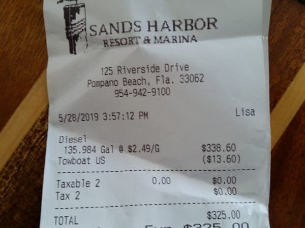
Sands Harbor Resort and Marina is on the east side of the Waterway, just north of the Atlantic Blvd Bridge. Our thanks to Frances Croswell for this money saving notice!
7/12/19 We bought diesel again Tuesday July 8, 2019 at $2.49 at Sands Harbour as previously discussed. I think your recent notice showed this price a/o 7/09 as well.
A nice and easy place to fill up!
Frances
5/29/19 Fyi, Sands Harbor Marina, Pompano Beach, FL. 954-942-9100 x6000 (North/east side of Atlantic Blvd bridge—Marathon fuel dock–right beside ICW for easy in out)
DIESEL at $2.49 today (local price war) BEFORE you get 10 cent discount for Boat US etc. We just bought last night…copy of receipt attached! A decent overnight stop too. They also have a frequent fueler program (attached).
Frances Croswell
Click here for Sands Harbor Marina


The age old issue of converting popular ICW anchorages, such as North and South Lakes in Hollywood, into mooring fields has in the past been associated with municipal waterfronts like St. Augustine. The mooring fields are considered to be a way to prevent derelicts and long term, unattended anchored vessels. See Anchoring Hassels in Hollywood, Florida and Sewage in Waterway Blamed on Boaters, Hollywood, FL.
Click here for Boat buoys could sink sailing on Hollywood lakes
Sun Sentinel
Stop in and give a big Welcome to one of our newest Sponsors! Only a mile or so upstream from downtown Jacksonville, Ortega Landing Marina, now A CRUISERS NET SPONSOR, is the first facility on your starboard as you enter the Ortega River from the St. Johns. Our thanks to Dave and Nan Fuller for these kind words as posted on AGLCA’s Forum.

We kept our boat for about 18 months at Ortega Landing. We loved both the marina with very nearby conveniences, and Jacksonville itself. It is just past downtown Jacksonville off the St. John’s river about 20 miles or so from the coast on the Ortega River. Tides here are about 18 inches and brackish water. Ortega Landing has floating concrete docks, great amenities, pump outs in slips, and lots of things you want just 3 to 4 blocks away including a Publix, West Marine, several restaurants, and other conveniences. There are several very good repair facilities within a half mile on the river. The only thing missing is covered slips and those are available about 1/4 mile away. Hard to beat this marina and pricing is competitive for this part of Florida.
Dave & Nan Ellen Fuller
WACI 3
Click Here To Open A Chart View Window, Zoomed To the Location of Ortega Landing Marina
These kind words for CRUISERS NET SPONSOR, Marineland Marina, were posted by Tim Gaffney on AGLCA’s Forum. With many recent facility upgrades and consistently good words from cruisers, Marineland Marina is located in Marineland, FL. See FOCUS ON Marineland Marina for more on this fine facility.
During our adventures we have spent 3-5 months all told at Marineland, 15 miles South of St. Augustine. Marina looks brand new, Dolphins swim inside the cove, 2 free tickets to see the Marineland scientific research center across the street.
If memory serves me cost is $1.25 a foot for a monthly stay. I think 30 amp for $35 a month. [See link below for all rates]
Eric really watches over the boats!
Did I mention the beach is right across the street?
Tim Gaffney
The Home Office
Click Here To View the Eastern Florida Cruisers Net Marina Directory Listing For Marineland Marina
Click Here To Open A Chart View Window, Zoomed To the Location of Marineland Marina
Ben Matthews is an experienced yachtsman and we are grateful for his sharing of his experience with the numerous engine problems possible with a new previously owned boat. Thankfully, it is a story with a happy ending. Westland Marina, A CRUISERS NET SPONSOR, is located on the southeastern shore of Titusville’s semi-enclosed harbor.
We had mechanical issues in Titusville that needed to be repaired. We recently purchased a (too) lightly used express cruiser we are moving from Florida to North Carolina. In Titusville, the starter on one of the engines failed and was fixed by Boater’s Edge which resides in the same building as Westland Marina. Truly a collaborative arrangement. Westland Marina is under new ownership and they are as nice and accommodating as they can be. I pulled the boat in on a Saturday and made arrangements after hours on their emergency call line, and then contacted Boater’s Edge that Monday. When I picked the boat up the next Friday all the work was done and I pulled out. Fuel issue. Came back. Jeff from Boaters Edge fixed it on the spot. Pulled out again. Circulating pump issue. Pulled in again. They had the part ordered and made arrangements to fix on the spot on Saturday – of Memorial Day Weekend no less – and got me up and on my way by 10am. Superb support and friendliness by Kyle and Jeff to get me back on the water again and headed north. I made 480 miles the next 3 days due to their overtime work and fast response! Also they helped with advice after the repair for my maintenance of it days later. Thanks Guys!
Although Westland Marine and Boater’s Edge are separate businesses, they work collaboratively to help boaters. Sean the nice marina manager has a really friendly Labrador who will play fetch while you wait and the lounge, shower, laundry, and restrooms are spotless and comfortable. Westland is generally a DIY yard and very lively with activity. Many useful stores (grocery, pharmacy, fast food) within a 20-minute walk, and a great ACE Hardware (with marine parts) is a 2 mile Uber/Lyft ride in the Florida heat.
Thanks Westland and B-E for a great experience in a challenging situation!
Ben Mathews
Click Here To View the Eastern Florida Cruisers Net Marina Directory Listing For Westland Marina
Click Here To Open A Chart View Window, Zoomed To the Location of Westland Marina
Experienced cruisers and frequent Cruisers Net contributors Jim and Peg Healy share their ships log and navigation watches as M/V Sanctuary travels north on the FL/GA Waterway. Thank you Jim and Peg!
Sanctuary and crew stayed last night (5/27) at Amelia Island Yacht Harbor. We departed northbound this morning (5/28/2019) at 06h00 with the tide at Kingsley Creek at +5.1′. We used Bob Shearer’s west side route through the shallows south of Fernandina Beach. That route is fine. We saw no less than 17 ft, so 12 ft at MLW. TowBoatUS is telling people to ignore G”1B” and stay to the east side of the canal, but we had no problems and can’t see why that advice is necessary. Both routes through that shallows appear to be quite viable.
Jim and Peg Healy aboard Sanctuary
Monk 36 Hull #132
See also NAV ALERT
See also Tom Hale Comments on Confusing Area South of Fernandina
Click Here To Open A Chart View Window, Zoomed To the Location of Amelia Island Yacht Basin
We went through this morning (5-29-19) 2 hrs before low tide 5′ draft, stayed to the west using the markers saw no less than 7′
For our tall-masted friends thinking of exploring the upper St. Johns River, Bruce Phaup kindly reminds us that the Shands Bridge with a fixed vertical clearance of 45ft connects Red Bay and Smith Points just south of Green Cove Springs. Funds have been approved for the replacement of Shands Bridge by the Florida Legislature, see links below. The bridge portion of the project is scheduled for completion in 2030.
The Shands Bridge, just south of Green Cove Springs, has a clearance of 45 feet. The Shands Bridge is the controlling height for the entire navigable extent of the St. John’s River, extending south to Sanford, Florida.
Bruce Phaup

Current Shands Bridge
Click here for Renderings of the new Shands Bridge
Click here for State funds $763M to replace Shands Bridge, extend beltway


Be the first to comment!