CRUISERS NET
Cruisers Helping Cruisers
Comprehensive cruising resource for the Intracoastal Waterways
from Norfolk to the Northern Gulf and Bahamas.
from Norfolk to the Northern Gulf and Bahamas.
FREE to use due to the generosity of our sponsors - please patronize them
Don’t get complacent with tropical outlook; ‘it only takes one’ – CoastalReview
Be the first to comment!
East Coast Major Storm Update – Fred Pickhardt
Fred Pickhardt’s Substack is free today. But if you enjoyed this post, you can tell Fred Pickhardt’s Substack that their writing is valuable by pledging a future subscription. You won’t be charged unless they enable payments.
 Forwarded this email? Subscribe here for more
East Coast Major Storm Update
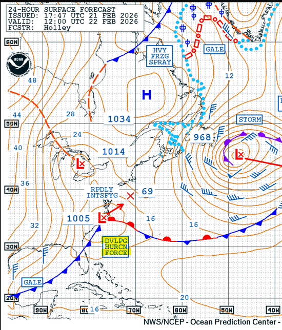
A major winter storm is forecast to impact the Mid-Atlantic and Northeast from Sunday, February 22, through Monday, February 23, 2026.


A powerful nor’easter is expected to produce widespread snowfall of 1 to 2 feet (12–24 inches) and blizzard conditions along coastal areas, resulting in nearly impossible travel and potential for numerous power outages.
Key Weather Hazards
- Blizzard Conditions: Millions of residents from coastal Delaware through southeastern New England are under blizzard warnings. High winds combined with heavy snow will cause whiteout conditions and near-zero visibility.
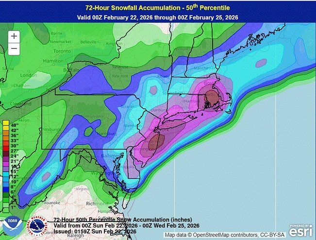
- Extreme Winds: Wind gusts are expected to range from 40 to 70 mph from coastal New Jersey to southeast New England.
- Power Outages: The combination of strong winds and the weight of heavy, wet snow is likely to cause scattered to numerous power outages.
- Coastal Flooding: Moderate to major coastal flooding and high surf are forecast, with inundation of roads and property most likely from Delaware to Cape Cod.
Travel and Safety Impacts
Travel will become treacherous to life-threatening starting Sunday afternoon. Officials have urged residents in major metropolitan areas, including New York City, to stay off the roads. Significant disruptions to travel and infrastructure are likely, including widespread flight cancellations and school closures on Monday.
Offshore Waters
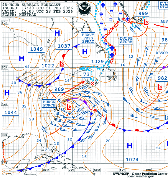
Storm to Hurricane force winds and seas building up to 9-11 meters within 180-360 nm south of the center during the next 36-48 hours.
NOAA US Coastal Waters Forecasts
NOAA Weather Prediction Center
You’re currently a free subscriber to Fred Pickhardt’s Substack. For the full experience, upgrade your subscription.
© 2026 Fred Pickhardt
548 Market Street PMB 72296, San Francisco, CA 94104
Unsubscribe

Be the first to comment!
- Blizzard Conditions: Millions of residents from coastal Delaware through southeastern New England are under blizzard warnings. High winds combined with heavy snow will cause whiteout conditions and near-zero visibility.
March Cruising Weather in the Gulf & Caribbean – Fred Pickhardt
Fred Pickhardt’s Substack is free today. But if you enjoyed this post, you can tell Fred Pickhardt’s Substack that their writing is valuable by pledging a future subscription. You won’t be charged unless they enable payments.
Forwarded this email? Subscribe here for moreMarch is one of the most popular months for cruising the Gulf of Mexico and the Caribbean—and for good reason. It sits right at the sweet spot between winter cold fronts and the start of the wetter summer pattern. For cruisers, that means comfortable temperatures, manageable seas, and very low risk of tropical weather…

Continue reading this post for free in the Substack app
Like
Comment
Restack
© 2026 Fred Pickhardt
548 Market Street PMB 72296, San Francisco, CA 94104Be the first to comment!
Hurricane Force Wind Warning: West Atlantic – Fred Pickhardt
Fred Pickhardt’s Substack is free today. But if you enjoyed this post, you can tell Fred Pickhardt’s Substack that their writing is valuable by pledging a future subscription. You won’t be charged unless they enable payments.
Forwarded this email? Subscribe here for more
A 1000 mb low at 36N 72W is moving NE at 25 knots with winds up to 45 knots and 5-meter seas. Within the next 30 hours the storm center will intensify significantly, with central pressure dropping to 966 mb. Winds will reach 55 to 70 knots with seas building 8 to 13 meters (approx. 26 to 43 feet) within 180 nm south of the low center.

You’re currently a free subscriber to Fred Pickhardt’s Substack.
Be the first to comment!
Severe Weather Risk For Southeast Update – Fred Pickhardt
Fred Pickhardt’s Substack is free today. But if you enjoyed this post, you can tell Fred Pickhardt’s Substack that their writing is valuable by pledging a future subscription. You won’t be charged unless they enable payments.
Forwarded this email? Subscribe here for more
There is a risk for severe weather across the Southeast through Sunday due to severe thunderstorms with potentially damaging gusty winds and a few possible tornadoes, particularly across northern Florida and Georgia, including the adjacent coastal waters.

There is a 5 to 15% risk for wind gusts in thunderstorms to exceed 50 knots producing Hazardous sea conditions over the coastal waters of parts of Florida and Georgia.
You’re currently a free subscriber to Fred Pickhardt’s Substack. For the full experience, upgrade your subscription.
© 2026 Fred Pickhardt
548 Market Street PMB 72296, San Francisco, CA 94104
Unsubscribe

Be the first to comment!
Storm Update: Marine Severe Weather Risk – Fred Pickhardt
Fred Pickhardt’s Substack is free today. But if you enjoyed this post, you can tell Fred Pickhardt’s Substack that their writing is valuable by pledging a future subscription. You won’t be charged unless they enable payments.
Forwarded this email? Subscribe here for more
A strong storm system is making its way across the South and East, bringing a threat of severe weather and localized flooding through Monday morning. For Saturday and Sunday, February 14-15th, the Storm Prediction Center indicates a 5-15% risk of severe thunderstorms capable of producing wind gusts of 50 knots or higher for the adjacent marine areas of the Gulf and portions of the coastal waters of Georgia and northern Florida.


Be the first to comment!
Severe Weather Threat to West-Central Gulf Coastal Waters – Fred Pickhardt
Fred Pickhardt’s Substack is free today. But if you enjoyed this post, you can tell Fred Pickhardt’s Substack that their writing is valuable by pledging a future subscription. You won’t be charged unless they enable payments.
Forwarded this email? Subscribe here for moreSevere weather is expected to impact the Southern U.S. from Saturday, February 14 (Valentine’s Day) into early Sunday morning. A potent storm system moving from the Southern Plains toward the Mississippi Valley will trigger multiple hazards across the region.

There will be at least a 15% probability of damaging thunderstorm winds or wind gusts of 50 knots or higher in the coastal waters of northeastern Texas to the coast of central Louisiana.

Be the first to comment!
Major East Coast Storm Update: Powerful Winter Storm Likely – Fred Pickhardt
Fred Pickhardt’s Substack is free today. But if you enjoyed this post, you can tell Fred Pickhardt’s Substack that their writing is valuable by pledging a future subscription. You won’t be charged unless they enable payments.
Forwarded this email? Subscribe here for more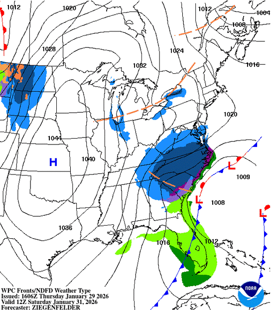
A powerful winter storm, forecast to intensify into a “bomb cyclone,” is expected to create dangerous marine conditions along the US East Coast and Western Atlantic from Saturday through Monday…
Continue reading this post for free in the Substack app
© 2026 Fred Pickhardt
548 Market Street PMB 72296, San Francisco, CA 94104
UnsubscribeBe the first to comment!
Weather Alert (Jan 29): Snowstorm This Weekend – SCDNR

Weather Alert – January 29, 2026
Snowstorm This Weekend
Key Points:
- A snowstorm is likely to affect South Carolina Friday night through Saturday night. A Winter Storm Watch is in effect for the entire state.
- Many areas may see light rain at the onset, and parts of the Coastal Plain may see up to a few hours of sleet and freezing rain. However, the risk for power outages will be low because significant ice buildup is unlikely, and the snow will be dry and fluffy.
- Snow will start Friday evening in the Upstate and spread over the state through the night, reaching I-20 by around midnight and the Lowcountry around daybreak.
- There remains uncertainty about how much snow will fall. However, the Catawba Region, the Pee Dee, and perhaps the Grand Strand will likely see the heaviest snowfall.
- Snow will taper off from west to east on Sunday, ending by daybreak in the Upstate and by midday along the Grand Strand.
- Winds will increase during the storm with peak gusts of 35-40 mph along the coast and around 30 mph elsewhere on Sunday. The wind will cause blowing and drifting snow where we see a substantial accumulation. The winds will also drive wind chills down to the single digits and teens over most of the state on Saturday through Sunday.
- Roads will become slippery for a few days where substantial snow falls because it will remain cold behind the storm, resulting in slow daytime melting and nighttime refreezing. The extent and duration of potential travel problems are uncertain; it will depend on how much snow falls.
It’s gonna snow this weekend, y’all, with impacts from the storm lingering into early next week. The only questions are how much, and who gets the heaviest.
In the meantime:
- A moisture-starved front in the area through tonight brings us some high clouds, but no rain or snow. Probably would have been snow with a better supply of moisture.
- Clouds will increase on Friday into Friday night ahead of the approaching storm. Highs on Friday will range from the low 40s in the Upstate to the upper 50s in the far south.
Uncertainty remains in the forecast, but there is more confidence than before. We can provide you with an accumulation forecast now; here’s what the National Weather Service (NWS) is calling for:

The current questions are about where the heaviest snow falls and how much we all see. The heaviest snow may fall over tomato-and-vinegar country instead of here, though it’s most likely that some of the heavy snow will affect the northern part of the state. The greatest uncertainty for snow amounts is over the Grand Strand and lower Pee Dee region; the ceiling is pretty high there, but the most likely scenario is relatively low. I just did a quick check before sending this out; it looks like the NWS is in the process of increasing the forecast snow for the Pee Dee region, so don’t be surprised to see the forecast for that area being bumped up.
Storms like these sometimes cause oddities, such as a large difference in snowfall over a relatively short distance, due to small bands of heavy snow that often form. Don’t be surprised if what falls in your backyard varies a lot from what a buddy of yours 15 miles away sees.
The primary impact will be slippery travel, since it’s going to be mainly dry, fluffy snow (parts of the coastal Plain might see a brief period of freezing rain that would make elevated roads slick like a muddy pig). Snow-covered roads will be a problem Saturday through Monday morning, and it’s going to remain cold behind this storm, so the roads could remain slick for a while. How hard it will become to get around and how long the roads remain bad will depend on how much snow falls. If you’re in an area that could see over three inches, start planning to avoid travel from Saturday through at least Monday. Areas to the south are likely to see lower impacts, but travel will be hazardous at least through Saturday and Sunday morning.
Bundle up if you go out to play in the snow or if you must be out for work or an emergency; this is among the coldest snow events we’ve seen. The frigid winds will bring a bite, so layer up! Do check your pipes if you didn’t before the last storm to ensure that they’re properly insulated, because it will be at least as cold behind this storm as it was after the last one.
What else can you do now? Check out SCEMD’s SC Winter Weather Guide and ready.gov for tips, and go from there.
Frank Strait
Severe Weather Liaison
S.C. State Climate Office


South Carolina Department of Natural Resources
260 D. Epting Lane
West Columbia, SC, 29172Stay Connected with SCDNR: 


SUBSCRIBER SERVICES:
Manage Subscriptions | Unsubscribe | HelpBe the first to comment!
New Climate Reports Show ‘Unprecedented Run of Global Heat’ – Inside Climate News (ICN)
Be the first to comment!
Weather Alert (Jan 28): Snow Likely This Weekend – SCDNR
Weather Alert – January 28, 2026
Snow Likely This Weekend
Key Points:
- Confidence is increasing for most or all of South Carolina to see a snowstorm this weekend.
- Mainly snow will fall, but many areas may see light rain at the onset, and parts of the Coastal Plain may see up to a few hours of sleet and freezing rain. However, the risk for power outages will be low because significant ice buildup is unlikely, and the snow will be dry and fluffy.
- Snow amounts are in question, and it’s still too early to provide specifics. However, it’s likely that the Catawba Region, the Pee Dee, and the Grand Strand will see the heaviest snowfall and have the best chance of three inches or more.
- The potential exists for slippery travel starting Friday night with snow falling through Saturday night. Roads may remain slippery for a few days where substantial snow falls because it will remain cold behind the storm, resulting in slow daytime melting and nighttime refreezing. The extent and duration of potential travel problems are uncertain.
- Winds will increase during the storm with peak gusts of 35-40 mph along the Coastal Plain and around 30 mph elsewhere on Sunday. The wind will cause blowing and drifting snow where we see a substantial accumulation. The winds will also drive wind chills down to the teens over most of the state on Saturday through Sunday and to the single digits Sunday night.
Another winter storm now looks likely for most or all of the state Saturday into Sunday. There is good computer model agreement that the storm will bring mainly snow, but they disagree on the amounts. Some show a major event with parts of the state seeing over six inches, while others show a peak of only a few inches.
In the meantime:
- We’ll remain dry ahead of the storm, but a moisture-starved cold front will move through tonight into Thursday. Highs on Thursday will range from the low 40s north to near 50 south.
- Clouds will increase on Friday ahead of the approaching storm. Highs on Friday will range from the low 40s in the Upstate to the upper 50s in the far south.
Uncertainties remain because of the complexity of the weather pattern over North America. The primary weather feature is moving southward from Hudson Bay today. It will cross the Great Lakes on Friday and reach the Tennessee Valley on Saturday. It will then move through the Carolinas and depart to the northeast on Saturday night into Sunday. Pacific disturbances now south of Alaska and west of Baja California may join with the storm and add moisture. However, the computer models could be off on the timing of those Pacific disturbances, and they may end up not becoming involved. More available moisture would lead to more snowfall.

This annotated infrared satellite image shows the complexity of our current weather pattern that leads to the uncertainties with this weekend’s potential winter storm:
- The track of the primary feature moving south from Hudson Bay is in question, and slight differences in its track could make a big difference in how severe the storm is for South Carolina.
- We may see weather features currently over the Pacific pulled into the weekend storm, and this would result in more moisture available and a more energetic storm.
- Other weather features not directly involved in the storm may still influence its behavior.
Image Source: University of Wisconsin RealEarth
However, the range of scenarios points to at least a little snow falling over some or all of South Carolina as early as Friday night. Some scenarios would lead to less moisture available, and some would result in the storm not really getting its act together until it’s moving away from us. Others show the storm intensifying by the time it gets here, bringing a major snowstorm that affects most of the state. The truth is somewhere in between, but the model trend over the last day has been toward more snow.
You can expect different impacts from this storm than from this past weekend’s, since it’s likely to bring snow rather than thick ice. Also, the snow will be dry and fluffy because it will be so cold, and it won’t adhere well to trees or power lines, so the risk for power outages will be low. Slick roads will be a problem, and it’s going to remain cold behind this storm, so the roads could remain slick for a while. How hard it will become to get around and how long the roads remain bad will depend on how much snow falls. It’s too early to give specific accumulation numbers (that’s coming tomorrow), but the area east of I-77 and north of U.S. 378 has the best chance of heavy snow. If you’re in that area, start planning to avoid travel Saturday through at least Monday. The rest of the state is likely to see lower impacts, but travel will be hazardous at least on Saturday and Sunday.
What else do you do now? Check out SCEMD’s SC Winter Weather Guide and ready.gov for tips, and go from there.

Frank Strait
Severe Weather Liaison
S.C. State Climate OfficeSouth Carolina Department of Natural Resources
260 D. Epting Lane
West Columbia, SC, 29172Stay Connected with SCDNR: SUBSCRIBER SERVICES:
Manage Subscriptions | Unsubscribe | HelpBe the first to comment!
Mardi Gras Fun in St. Marys & Kingsland, St Marys, Georgia, off AICW MM 712
During Mardi Gras or anytime be sure to stay at St Marys Intracoastal Gateway Marina, a CRUISERS NET SPONSOR!
2026 Mardi Gras Fun in St. Marys & Kingsland
KINGSLAND: FEBRUARY 6-7 ~~~ ST. MARYS FEBRUARY 15 & 17
KINGSLAND: FEBRUARY 6 & 7, 2026
ST. MARYS: FEBRUARY 15 & 17, 2026
Let the Good Times Roll in St. Marys and Kingsland with a free concert with a nationally recognized artist (Collin Raye played in 2025), pirates, a family day, and a nighttime illuminated parade and concert.
When you think of Mardi Gras, your mind might drift to the spirited streets of New Orleans, but there’s another area where the spirit of Mardi Gras comes alive in a uniquely Southern way—Camden County, Georgia. Less than an hour north of Jacksonville, Florida, situated along the scenic southeastern coast, Camden County is home to two charming cities, Kingsland and St. Marys, that are both pulling out all the stops to deliver a memorable Mardi Gras experience. Here, you’ll find lively parades and toe-tapping concerts alongside family-friendly festivities and dazzling evening events, so consider this your invitation to join in on the celebration.
Kingsland Kicks Off the Festivities February 6 & 7, 2026
The Mardi Gras magic commences in Kingsland, just fifteen minutes from downtown St. Marys, with the K-BAY Mardi Gras Festival. On Friday, the festival kicks off with live music from 6-10 PM setting the tone for a weekend filled with rhythm and revelry. Saturday then ramps up the excitement with a full day of activities beginning at 9 AM, including the Mardi Gras Parade at 10 AM, where the streets are filled with camaraderie and cheer. Post-parade, the festival grounds come alive with creative vendors, unique crafts, fantastic festival food, and free concerts. The evening culminates with a performance by a chart-topping music legend at 6 PM promising a night of unforgettable entertainment. For Kingsland parade applications, vendor inquiries, or more information, visit the K-BAY Festival website here or call 912-729-6000.
SUNDAY, FEBRUARY 15, 2026
St. Marys Takes Center Stage for Family-Friendly Fun with the St. Marys Mardi Gras Jubilee at the St. Marys Waterfront Park on Sunday, February 15, 2026.
The St. Marys Mardi Gras Jubilee, held from 1-4 PM at the St. Marys Waterfront Park (201 St. Marys Street, St. Marys, Georgia 31558; 912-882-4000), is designed to delight visitors of all ages. Kids will be in heaven with a Kids Court featuring a Lucky Ducks game, football toss, Mardi Gras mask making station, Connect Four, Wheel of Fortune, Plinko, and face painting. The St. Marys Pirates Buccaneer Fun Zone will host Chuck-a-Duck, “Reel” fishing, and Ring Around the Sword games and kids can learn how to talk like a pirate and get to walk the plank. Other activities include miniature golf putting greens and bounce houses and an interactive golf experience.
It will be a carnival-like atmosphere where laughter and joy are guaranteed. Meanwhile, parents can relax and enjoy a lively DJ who will keep the energy elevated throughout the afternoon. What is a Mardi Gras Jubilee without king cake? Indulge in this traditional treat alongside a variety of delicious meal and dessert food trucks. The waterfront setting creates a gorgeous backdrop to the festivities, making it the perfect spot to unwind and soak in the Mardi Gras spirit.
TUESDAY, FEBRUARY 17, 2026
Fat Tuesday Fest in downtown St. Marys.
Fast forward to Fat Tuesday where, as the sun sets, the celebration continues with Fat Tuesday Fest – an Illuminated Parade & Party in the Park on Tuesday, February 17th. The evening kicks off at 6:30 PM with an illuminated parade that will light up the streets of St. Marys. The parade will start at Church Street and end at the waterfront park. Following the parade, the party moves to the park for a 7:30 – 9PM concert. This is your night to glow, sparkle, and be flashy! For St. Marys parade applications, to vote for your favorite decorations, or more information, go to www.visitstmarys.com or call 912-882-4000.
A Citywide Celebration of Mardi Gras Magic
The Mardi Gras spirit isn’t confined to the events. In fact, it’s alive all-around town! St. Marys is hosting a citywide Mardi Gras window and porch decorating contest, encouraging residents and businesses to showcase their creativity and festive flair. Take a stroll through the charming streets and admire colorful displays that add to the celebratory atmosphere. Use the QR displayed in the window to vote for your favorite. More to come on this later!
Plan Your Mardi Gras Getaway to Camden County
Camden County, Georgia, is the ideal destination for a Mardi Gras celebration that combines tradition, family fun, and Southern hospitality. Whether you’re dancing to live music in Kingsland, reveling in waterfront festivities in St. Marys, or simply soaking in the jubilant decorations around town, you’ll find that this corner of Georgia knows how to throw a party.
Start planning your Mardi Gras getaway today and be sure to stay current on local events, accommodations, attractions by checking out www.visitstmarys.com Bring some beads so you’ll be ready to experience an authentic Camden County Mardi Gras. As the French say, Laissez les bons temps rouler—let the good times roll!

Mardi Gras Celebrations in St. Marys!
Mardi Gras Fun in St. Marys & Kingsland
Be the first to comment!
Weekend Winter Storm Update – SCDNR
Weather Alert – January 21, 2026
Weekend Winter Storm Update
Key Points:
- A Winter Storm Watch is now in effect for much of northern South Carolina, including the Upstate, Catawba Region and Chesterfield County.

A map showing the counties under a Winter Storm Watch, highlighted in blue
- Confidence continues to increase that at least a part of South Carolina will be affected by a major, long-duration winter storm this weekend.
- However, the storm’s forecast track has shifted northward, lessening potential impacts for areas along and south of I-20. Timing has changed as well, with the storm starting in the afternoon or evening on Saturday and lasting into early Monday.
- The storm’s details, such as precipitation type, remain uncertain. Shifting computer model output will likely lead to more forecast changes.
- Most likely scenario, not heavily favored due to uncertainty:
- Snow, if any, and sleet in the Upstate starting on Saturday, will eventually turn to freezing rain. There may be a sleet accumulation into Saturday night, and a damaging ice buildup is possible on Sunday. Travel will be hazardous through at least Monday morning. Should there be a significant sleet accumulation, it would be slow to melt behind the storm as it remains cold.
- Across the CSRA, the Midlands, and northern Pee Dee, freezing rain may dominate north of I-20, with a chance of damaging ice accumulation and slippery travel Saturday night into Sunday. Areas along and south of I-20 see freezing rain for a time, then rain as temperatures warm above freezing on Sunday.
- Areas further south and east may see freezing rain for a time Saturday night, then rain Sunday. Elevated road surfaces could become icy for a time.
- The Lowcountry and Grand Strand primarily see rain, though a period of freezing rain is possible at the onset, especially inland. Some models show it warming up enough on Sunday for thunderstorms.
- Worst-case scenarios include:
- A severe ice storm is possible where freezing rain is dominant; the best chance appears to be in the Upstate, the Catawba Region, and the northern CSRA and Midlands.
- Continued northward shifts in the storm track would shift the potential for sleet accumulations out of South Carolina, but a damaging ice storm would still occur in the Upstate. Less of the state would be at risk for a damaging ice buildup.
- A more southerly track of the storm would bring heavy snow and sleet back into South Carolina, with a damaging ice storm further south, as previously thought. This idea is looking increasingly unlikely. However, the warmer, further north computer models may not be handling this weekend’s cold-air damming, and temperatures may remain below freezing near I-20 longer than the models indicate, resulting in a significant ice buildup in that area.
Good afternoon. A northward shift in the computer model guidance on the track of a winter storm for much of the nation changes the potential impacts here in South Carolina.
The forecast for now through Friday night remains unchanged:
- We remain dry through most of tonight.
- The next cold front will move in on Thursday, bringing light rain to the Upstate, possibly starting by daybreak in some areas.
- Light rain is possible over much of the state Thursday night into Friday evening as this cold front slowly sinks southward.
- Arctic air will filter into South Carolina behind this front starting Friday evening.
Our next storm, currently approaching California, will reach us on Saturday. It has become unlikely that any significant snow will fall in the state (a little at the onset maybe), but sleet and freezing rain are likely to affect much of the state. The computer models continue to show a range of possibilities, but the trend has been our friend, showing less of the state experiencing significant impacts.
It would be best to start your preparations soon if you’re in an area that still may be hit by a damaging ice storm and slippery travel. How do you deal with it? SCEMD’s SC Winter Weather Guide is a good starting point, and you can get more tips on winter storm preparedness at ready.gov. Pay close attention to the generator safety and kerosene and propane heater safety tips; carbon monoxide is quite the villain.
The picture should get increasingly clearer over the next couple of days as we get closer to the event. Another update is coming on Thursday!

Frank Strait
Severe Weather Liaison
S.C. State Climate OfficeSouth Carolina Department of Natural Resources
260 D. Epting Lane
West Columbia, SC, 29172Stay Connected with SCDNR: SUBSCRIBER SERVICES:
Manage Subscriptions | Unsubscribe | HelpThis email was sent to curtis.hoff@cruisersnet.net using GovDelivery Communications Cloud on behalf of: South Carolina DNR ·1000 Assembly Street · Columbia, SC 29201 Be the first to comment!


Social Media Auto Publish Powered By : XYZScripts.com
Be the first to comment!