Visit Logged
  • Select Region
    • All Regions
    • VA to NC Line
    • North Carolina
    • South Carolina
    • Georgia
    • Eastern Florida
    • Western Florida
    • Florida Keys
    • Okeechobee Waterway
    • Northern Gulf
    • Bahamas
    • New York
    • Ohio
    • Pennsylvania
    • Washington
    • Puerto Rico
    • Minnesota
    • Maryland
    • Tennessee
    Order by:
    • LNM: Off AIWW MM:666.1, Hampton River Daybeacon 12 Missing


      SAFETY/GA – ALTAMAHA SOUND – HAMPTON RIVER/ATON/SEC CHS BNM 0222-25


      united states coast guard

      1. HAMPTON RIVER DAYBEACON 12 (LLNR 5975) IS REPORTED MISSING. ALL MARINERS ARE REQUESTED TO TRANSIT THE AREA WITH CAUTION.
      CANCEL AT//120559Z NOV 25//

      BT


      This email was sent to curtis.hoff@CruisersNet.net using GovDelivery Communications Cloud on behalf of: U.S. Coast Guard · U.S. Department of Homeland Security · Washington, DC 20528 · 800-439-1420GovDelivery logo

      *** THIS DIV IS AUTOMATICALLY HIDDEN WHEN DISPLAYED – INFO FOR DEBUGGING PURPOSES ***
      ***MANUALLY DO: FIX TITLE, EXPIRE DATE, CATEGORIES, ENABLE SOCIAL POST ***
      0: llnr: 5975 District: 07 lat/lon: 31.245423,-81.332255 Desc: Hampton River Daybeacon 12

      WW: blat (31.25758) , blon (-81.39514) , bWWid (5) , bMM (666.1) , bDOffWW (3.8) , bAbbrev (AIWW) , bWWName (Atlantic Intracoastal Waterway.gpx)

      Be the first to comment!

    • LNM: AIWW MM:677.2, Mackay River Light 250 Missing


      UPDATE/GA-ST SIMONS ISLAND- MACKAY RIVER/ATON/SEC CHS BNM 0210-25 UPDATE-1


      united states coast guard

      MACKAY RIVER LIGHT 250 (LLNR 37215) PREVIOUSLY REPORTED TO BE MISSING IS NOW DESTROYED. A TEMPORARY LIGHT FLASHING 2.5 R IS ON STATION. ALL MARINERS ARE REQUESTED TO TRANSIT THE AREA WITH CAUTION.
      CANCEL AT//071849Z NOV 25//

      BT


      This email was sent to curtis.hoff@CruisersNet.net using GovDelivery Communications Cloud on behalf of: U.S. Coast Guard · U.S. Department of Homeland Security · Washington, DC 20528 · 800-439-1420GovDelivery logo

      *** THIS DIV IS AUTOMATICALLY HIDDEN WHEN DISPLAYED – INFO FOR DEBUGGING PURPOSES ***
      ***MANUALLY DO: FIX TITLE, EXPIRE DATE, CATEGORIES, ENABLE SOCIAL POST ***
      0: llnr: 37215 District: 07 lat/lon: 31.132033,-81.422871 Desc: Mackay River Light 250

      WW: blat (31.13470) , blon (-81.42021) , bWWid (5) , bMM (677.2) , bDOffWW (0.2) , bAbbrev (AIWW) , bWWName (Atlantic Intracoastal Waterway.gpx)

      Be the first to comment!

    • LNM: Off AIWW MM:676.8, Cedar Hammock Range Front Light Destroyed


      SAFETY/GA – JEKYLL ISLAND – BRUNSWICK RIVER/ATON/SEC CHS BNM 0214-25


      united states coast guard

      1. CEDAR HAMMOCK RANGE FRONT LIGHT (LLNR 6195) IS DESTROYED. ALL MARINERS ARE REQUESTED TO TRANSIT THE AREA WITH CAUTION.
      CANCEL AT//061846Z NOV 25//

      BT


      This email was sent to curtis.hoff@CruisersNet.net using GovDelivery Communications Cloud on behalf of: U.S. Coast Guard · U.S. Department of Homeland Security · Washington, DC 20528 · 800-439-1420GovDelivery logo

      *** THIS DIV IS AUTOMATICALLY HIDDEN WHEN DISPLAYED – INFO FOR DEBUGGING PURPOSES ***
      ***MANUALLY DO: FIX TITLE, EXPIRE DATE, CATEGORIES, ENABLE SOCIAL POST ***
      0: llnr: 6195 District: 07 lat/lon: 31.101491,-81.462586 Desc: Cedar Hammock Range Front Light

      WW: blat (31.13933) , blon (-81.42485) , bWWid (5) , bMM (676.8) , bDOffWW (3.4) , bAbbrev (AIWW) , bWWName (Atlantic Intracoastal Waterway.gpx)

      Be the first to comment!

    • LNM: Off AIWW MM:676.3, Plantation Creek Range Rear Light Destroyed


      SAFETY/GA – BRUNSWICK – BRUNSWICK RIVER/ATON/SEC CHS BNM 0212-25


      united states coast guard

      1. PLANTATION CREEK RANGE REAR LIGHT (LLNR 6135) IS DESTROYED. ALL MARINERS ARE REQUESTED TO TRANSIT THE AREA WITH CAUTION.
      CANCEL AT//060400Z NOV 25//

      BT


      This email was sent to curtis.hoff@CruisersNet.net using GovDelivery Communications Cloud on behalf of: U.S. Coast Guard · U.S. Department of Homeland Security · Washington, DC 20528 · 800-439-1420GovDelivery logo

      *** THIS DIV IS AUTOMATICALLY HIDDEN WHEN DISPLAYED – INFO FOR DEBUGGING PURPOSES ***
      ***MANUALLY DO: FIX TITLE, EXPIRE DATE, CATEGORIES, ENABLE SOCIAL POST ***
      0: llnr: 6135 District: 07 lat/lon: 31.140151,-81.446045 Desc: Plantation Creek Range Rear Light

      WW: blat (31.14486) , blon (-81.42840) , bWWid (5) , bMM (676.3) , bDOffWW (1.1) , bAbbrev (AIWW) , bWWName (Atlantic Intracoastal Waterway.gpx)

      Be the first to comment!

    • LNM: Off AIWW MM 675.2 Turtle River Lower Range Rear Light Destroyed


      SAFETY/GA – BLYTHE ISLAND – BRUNSWICK RIVER/ATON/SEC CHS BNM 0215-25


      united states coast guard

      1. TURTLE RIVER LOWER RANGE REAR LIGHT IS DESTROYED. ALL MARINERS ARE REQUESTED TO TRANSIT THE AREA WITH CAUTION.
      CANCEL AT//061848Z NOV 25//

      BT


      This email was sent to curtis.hoff@CruisersNet.net using GovDelivery Communications Cloud on behalf of: U.S. Coast Guard · U.S. Department of Homeland Security · Washington, DC 20528 · 800-439-1420GovDelivery logo

      *** THIS DIV IS AUTOMATICALLY HIDDEN WHEN DISPLAYED – INFO FOR DEBUGGING PURPOSES ***
      ***MANUALLY DO: FIX TITLE, EXPIRE DATE, CATEGORIES, ENABLE SOCIAL POST ***

      Be the first to comment!

    • LNM: AIWW MM:651.9, Rockdedundy River Light 183 Destroyed


      SAFETY/GA – ROCKDEDUNDY RIVER/ATON/SEC CHS BNM 0211-25


      united states coast guard

      1. ROCKDEDUNDY RIVER LIGHT 183 (LLNR 36825) IS DESTROYED. ALL MARINERS ARE REQUESTED TO TRANSIT THE AREA WITH CAUTION.
      CANCEL AT//060400Z NOV 25//

      BT


      This email was sent to curtis.hoff@CruisersNet.net using GovDelivery Communications Cloud on behalf of: U.S. Coast Guard · U.S. Department of Homeland Security · Washington, DC 20528 · 800-439-1420GovDelivery logo

      *** THIS DIV IS AUTOMATICALLY HIDDEN WHEN DISPLAYED – INFO FOR DEBUGGING PURPOSES ***
      ***MANUALLY DO: FIX TITLE, EXPIRE DATE, CATEGORIES, ENABLE SOCIAL POST ***
      0: llnr: 36825 District: 07 lat/lon: 31.384817,-81.331405 Desc: Rockdedundy River Light 183

      WW: blat (31.38517) , blon (-81.33242) , bWWid (5) , bMM (651.9) , bDOffWW (0.1) , bAbbrev (AIWW) , bWWName (Atlantic Intracoastal Waterway.gpx)

      Be the first to comment!

    • LNM: AIWW MM:677.2, Mackay River Light 250 Missing


      SAFETY/GA-ST SIMONS ISLAND- MACKAY RIVER/ATON/SEC CHS BNM 0210-25


      united states coast guard

      1. MACKAY RIVER LIGHT 250 (LLNR 37215) IS MISSING. ALL MARINERS ARE REQUESTED TO TRANSIT THE AREA WITH CAUTION.
      CANCEL AT//060400Z NOV 25//

      BT


      This email was sent to curtis.hoff@CruisersNet.net using GovDelivery Communications Cloud on behalf of: U.S. Coast Guard · U.S. Department of Homeland Security · Washington, DC 20528 · 800-439-1420GovDelivery logo

      *** THIS DIV IS AUTOMATICALLY HIDDEN WHEN DISPLAYED – INFO FOR DEBUGGING PURPOSES ***
      ***MANUALLY DO: FIX TITLE, EXPIRE DATE, CATEGORIES, ENABLE SOCIAL POST ***
      0: llnr: 37215 District: 07 lat/lon: 31.132033,-81.422871 Desc: Mackay River Light 250

      WW: blat (31.13470) , blon (-81.42021) , bWWid (5) , bMM (677.2) , bDOffWW (0.2) , bAbbrev (AIWW) , bWWName (Atlantic Intracoastal Waterway.gpx)

      Be the first to comment!

    • St. Simons Island Overnight & Transient Dockage


      Morningstar Marinas - Boating as it should be. Long-term or transient.

      Morningstar Marina at Golden Isles,  A CRUISERS NET SPONSOR, lies along the southern reaches of the Frederica River, between Lanier and St. Simons Islands, south of the charted 9 foot bridge. 

      Located on St. Simons Island, GA Morningstar Marina Golden Isles is right off the ICW Marker 675 with easy access to the ocean. The Frederica River provides no vertical obstructions, and we are a deep craft marina, making us a welcome stop for yachts and sailboats for overnight & transient dockage. Our Golden Isles location is home to highly trained dock masters who pair their extensive training and knowledge with superior service, delivering exceptional experiences that go beyond the norm. The overnight & transient dockage facilities for boats at Golden Isles have been designed to serve the specialized needs of today’s boaters offering 1,100 linear feet of transient dock with high-speed fuel pumps, in-slip pump out, free On Spot Wi-Fi, and 30/50/100-amp shore power service. Additional amenities include secure bathroom and shower facilities, laundry facilities, a fully stocked marina ship store, courtesy bicycles and vehicle, a swimming pool, with an onsite restaurant and coffee shop. Beyond the marina facilities, we are two miles away from St. Simons Island and the Golden Isles where you can enjoy the beaches, historic sites, golf, tennis, shopping, and amazing dining. Please submit a request by filling out the form below.

      Morningstar Marinas Golden Isles at Sunset

      Click Here To View the Cruisers Net Georgia Marina Directory Listing For Morningstar Marina at Golden Isles

      Click Here To Open A Chart View Window Zoomed To the Location of Golden Isles Marina

      Be the first to comment!

    • Brownbag February 11th- Collecting Acoustic Data in the Coastal Ocean: New Insights from Autonomous Underwater Vehicles, Brunswick, GA

       
      GA Coastal 1200 header
       

      Brownbag Presentation

      February 11th, 2025 

      Brownbag 12:00PM-1:00PM

      Science After Party 1:00PM-2:30PM

      Brownbag will be held at the Susan Shipman Environmental Learning Center @ GADNR Coastal Regional Headquarters

            One Conservation Way, Brunswick, GA 31520

      Please join the GA Coastal Management Program for a Brownbag Presentation on Collecting Acoustic Data in the Coastal Ocean: New Insights from Autonomous Underwater Vehicles by Dr. Catherine Edwards and Frank McQuarrie with the Skidaway Institute of Oceanography. 

      Gliders are autonomous underwater vehicles, or ocean robots, that fly by changing their buoyancy and center of gravity, which makes them a relatively quiet platform for collecting acoustic data in the coastal ocean. Catherine Edwards will give an overview of her recent work in coastal Georgia using gliders for acoustic telemetry and real-time monitoring of right whales using passive acoustics, give some examples of how understanding environmental conditions can help inform interpretation of the acoustic data, and consider how to leverage these data streams to design smart systems for fisheries science and management. 

      Science After Party: In the science after-party, Frank McQuarrie will dig into the data from recent acoustic telemetry work at Gray’s Reef National Marine Sanctuary in more detail, and consider what processes control the effectiveness of telemetry on tidal, daily, weather, and seasonal time scales, showing data from Gray’s Reef as evidence. The second half of the after party will be a group discussion to consider the practical implications for interpretation of the data for management purposes. 

      Frank at work
      Glider Selfie

      Speaker Bios:

      Dr. Catherine Edwards is a physical oceanographer and Associate Professor at the Skidaway Institute of Oceanography and in the Department of Marine Sciences at University of Georgia.  Edwards’s research focuses on answering fundamental questions in coastal oceanography and fisheries sciences with autonomous underwater vehicles, developing novel ways to optimize their use with engineering principles and real-time data streams from models and observations. Her work has been featured in local, regional, and national press, including NPR’s All Things Considered, Science Magazine, WIRED, Forbes, and The Weather Channel. 

      Frank McQuarrie is a PhD candidate in the Edwards Lab at the Skidaway Institute of Oceanography focusing on acoustic telemetry efficiency. He first saw a glider at Rutgers in 2011 and they have fascinated him since, he loves deploying/piloting/retrieving them as acoustic receiver platforms around the South Atlantic Bight.

      Acoustics in the Ocean Calendar Download Link


      Please reach out to Kelly Hill with questions at Kelly.Hill@dnr.ga.gov


      20 years of Sustaining, Protecting,Enhancing, and Conserving

      video

      Support Habitat Conservation with your License Plate

      tag


      Be the first to comment!

    • Response from Morningstar Marina at Golden Isles, AICW MM 676, Frederica River, GA

      Morningstar Marinas - Boating as it should be. Long-term or transient.

      Morningstar Marina at Golden Isles,  A CRUISERS NET SPONSOR, lies along the southern reaches of the Frederica River, between Lanier and St. Simons Islands, south of the charted 9 foot bridge. 

      Click Here To View the Cruisers Net Georgia Marina Directory Listing For Morningstar Marina at Golden Isles

      Click Here To Open A Chart View Window Zoomed To the Location of Golden Isles Marina

      Be the first to comment!

    • Unique Sailing Vessel at Morningstar Marina at Golden Isles, AICW MM 676


      Morningstar Marina at Golden Isles,  A CRUISERS NET SPONSOR, lies along the southern reaches of the Frederica River, between Lanier and St. Simons Islands, south of the charted 9 foot bridge.

      “Was pretty cool to see this at our transient dock today. All carbon fiber and Kevlar. Captain said she will do 33knts. Couldn’t imagine what she costs but she’s one of a kind.”
      Marina Staff

      Click Here To View the Cruisers Net Georgia Marina Directory Listing For Morningstar Marina at Golden Isles

      Click Here To Open A Chart View Window Zoomed To the Location of Golden Isles Marina


      Be the first to comment!

    • USCG Aircrew Rescue off Georgia Coast

      The Coast Guard doing what they do so well. Our thanks to Ted Arisaka for this report.

      Be the first to comment!

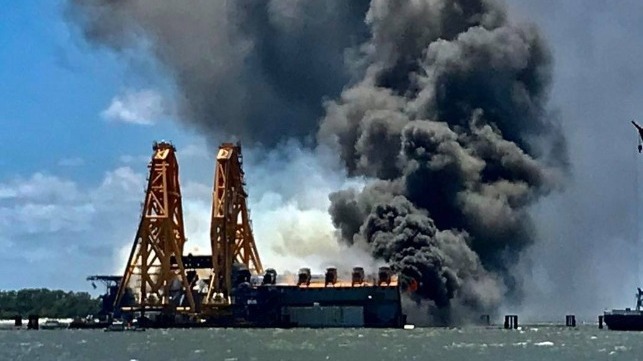
    • Golden Ray’s Owners and Salvage Company Sued for Negligence in Salvage


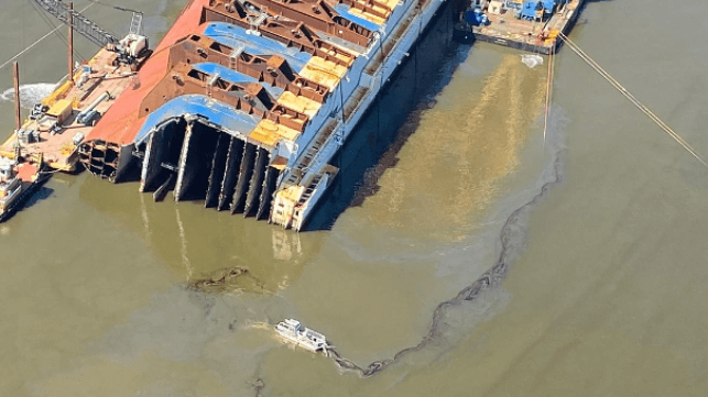
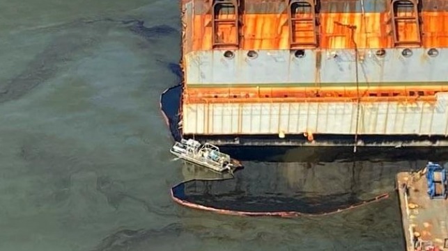
      The  saga of the transport Golden Ray, with its incredible photography in which cars looked like bugs pouring out of a hive, has finally come to a close. The Golden Ray went aground and partially capsized in Georgia’s St. Simons Sound on September 7, 2019. With numerous delays, the wreck of the capsized PCTC has taken more than two years to remove from St. Simons Sound. See Heavy Lift Barge Departs. Note: if you missed them, the earlier extraordinary photos can be accessed by typing “golden ray” in the search window of our Homepage.

      The suit cites the numerous oil leaks during the salvage (USCG photo)

      Golden Ray’s Owners and Salvage Company Sued for Negligence in Salvage
      Maritime Executive

      Be the first to comment!

    • Shared Photo – Walburg Creek, GA


      Walburg Creek Anchorage is off the AICW and accessed from MM 619 or 623.5. Our thanks to Ted Arrisaka for sharing this photo. This editor and crew have spent many a night here.

      Click Here To View the Georgia Anchorage Cruisers Net Anchorage Directory Listing For the Walburg Creek Anchorage

      Click Here To Open A Chart View Window, Zoomed To the Location of the Walburg Creek Anchorage

      Comments from Cruisers (1)

      1. Ted Arisaka -  December 24, 2021 - 3:37 pm

        One of Georgia's gems! Sandy beach by the north entrance at low tide. Beautiful sunset over the marsh to the west. Good protection. From the wind E thru SSE. Good holding, ground tackle comes up clean.

        Reply to Ted
    • Georgia Proposed $3 Million Pollution Fine for Golden Ray’s Operators

      The  saga of the transport Golden Ray, with its incredible photography in which cars looked like bugs pouring out of a hive, has finally come to a close. The Golden Ray went aground and partially capsized in Georgia’s St. Simons Sound on September 7, 2019. With numerous delays, the wreck of the capsized PCTC has taken more than two years to remove from St. Simons Sound. See Heavy Lift Barge Departs. Note: if you missed them, the earlier extraordinary photos can be accessed by typing “golden ray” in the search window of our Homepage.


      Oil leaking from the Golden Ray in the summer of 2021 (St. Simons Sound Incident response photos)


      Georgia Proposed $3 Million Pollution Fine for Golden Ray’s Operators
      Maritime Executive

      Be the first to comment!

    • NAV ALERT: near AICW MM 633 Shoaling Reported, Entrance Channel, Sapelo Sound, GA


      The entrance to Sapelo Sound has been a shoal prone area for some time. See Shoaling Reported. Our thanks to Robert J Norman for this report.


      Severe shoaling has been reported by a cruising boat while entering Sapelo Sound, Georgia, between R6 and R8 causing significant damage to rudder and rig. Robert J Norman

      Be the first to comment!

    • Heavy Lift Barge Departs Golden Ray Site, St Simons Sound, GA


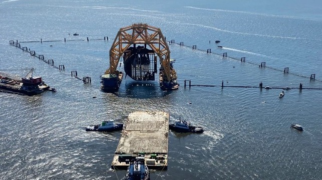
      The  saga of the transport Golden Ray, with its incredible photography in which cars looked like bugs pouring out of a hive, is finally coming to a close. The Golden Ray went aground and partially capsized in Georgia’s St. Simons Sound on September 7, 2019. With numerous delays, the wreck of the capsized PCTC has taken more than two years to remove from St. Simons Sound, Georgia. See Last Section. Note: if you missed them, the earlier extraordinary photos can be accessed by typing “golden ray” in the search window of our Homepage.


      VB 10,000 carries out one of its very last lifts for the Golden Ray wreck removal, Oct. 2021 (St. Simons Sound Incident Response)


      Heavy Lift Barge Departs Golden Ray Site After Yearlong Wreck Removal
      Maritime Executive

      Be the first to comment!

    • Last Section of Golden Ray Removed From St. Simons Sound, GA


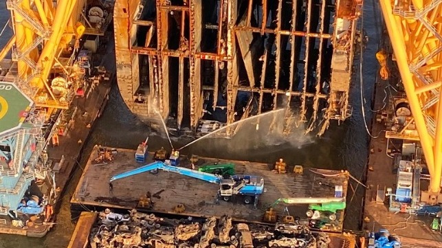
      The  saga of the transport Golden Ray, which went aground and partially capsized in Georgia’s St. Simons Sound on September 7, 2019, may finally be coming to a close. With numerous delays, the wreck of the capsized PCTC has taken more than two years to remove from St. Simons Sound, Georgia. See Last Section Emerges.


      Last Section of Golden Ray Removed From St. Simons Sound
      Maritime Executive

      Be the first to comment!

    • Video: Last Section of Golden Ray Emerges From the Water, St Simons Sound, GA


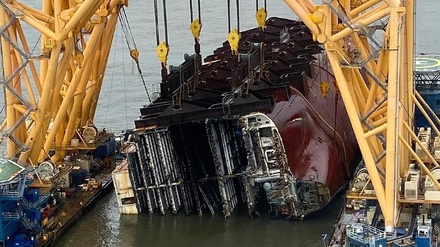
      The  saga of the transport Golden Ray, which went aground and partially capsized in Georgia’s St. Simons Sound on September 7, 2019, may finally be coming to a close. With numerous delays, the wreck of the capsized PCTC has taken more than two years to remove from St. Simons Sound, Georgia. See Photos: Salvors Lift Final Section.


      Damage to hull structure is visible at lower right (upper port) side of the hull (St. Simons Sound Incident Response)


      Video: Last Section of Golden Ray Emerges From the Water
      Maritime Executive

      Be the first to comment!


    Social Media Auto Publish Powered By : XYZScripts.com