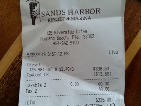
Sands Harbor Resort and Marina is on the east side of the Waterway, just north of the Atlantic Blvd Bridge. Our thanks to Frances Croswell for this money saving notice!
7/12/19 We bought diesel again Tuesday July 8, 2019 at $2.49 at Sands Harbour as previously discussed. I think your recent notice showed this price a/o 7/09 as well. A nice and easy place to fill up! Frances
5/29/19 Fyi, Sands Harbor Marina, Pompano Beach, FL. 954-942-9100 x6000 (North/east side of Atlantic Blvd bridge—Marathon fuel dock–right beside ICW for easy in out)
DIESEL at $2.49 today (local price war) BEFORE you get 10 cent discount for Boat US etc. We just bought last night…copy of receipt attached! A decent overnight stop too. They also have a frequent fueler program (attached). Frances Croswell
As Blades Robinson relates below, this straight narrow channel exits Cape River northbound at lighted ICW marker 177 and ends at the southern entrance to Snows Cut. In April, ICW marker 163 was reported off-station. Our thanks to Blades for this update.
Channel from Marker 177 to 164 Near MM-297 / Good depth We ran this cut today at dead low tide and had a MINIMUM of 7 feet of depth and saw mostly ten and twelves on the depth recorder. FYI. Blades Robinson
The marked entry channel to Deep Point Marina – A CRUISERS NET SPONSOR! – lies northwest of Cape Fear River/AICW marker #20.Our thanks to Blades Robinson for this review.
I had a great visit to Deep Point Marina and look forward to a return visit. Dock master Shan provided good information and shared his local knowledge. A taxi driver (Ellen, who lives aboard at the marina) gave us a ride to “town” for $8 where we enjoyed ice cold adult beverages and an excellent seafood dinner. The marina pool was refreshing and the complimentary washing machines/driers were an added bonus. Before leaving this morning we had an excellent breakfast in the coffee shop located in the Bald Head Island ferry terminal located next door to the marina. The fact that they support the CruisersNet makes this a worthwhile stop. Blades Robinson
Time to give the Bahamas government a spanking. Staying in the U.S. next year. It's really better anyway. Bahamas trip expense has gotten way out of control. The Government wasteful spending has necessitated the increases.
Making it unaffordable for many. $240/ month VAT tax based on light average spend cooking on the boat and an occasional happy hour drink. My $2,000 a month for businesses will go away. Going from $300 a year to $4,000 a year for a cruising permit? Did I read that right or is it still not finalized? The economy is great there because of the boaters. Now you are going to impose even higher fees. Talk about “killing the goose that laid the golden egg….â€
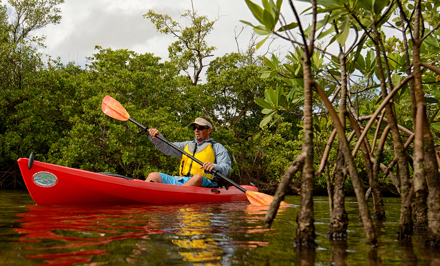
This is a great way to show your concern for Florida manatees and sea turtles, as well as to support Florida’s Wildlife Foundation.
New manatee and sea turtle decals: coming soon to a bumper near you
The Florida Fish and Wildlife Conservation Commission (FWC), is unveiling its new 2019 manatee and sea turtle decals. These high-quality stickers, featuring beautiful original artwork, are a fun way for people to support the research, rescue and management efforts that conserve these species and spread the word about the challenges they face.
Every July, the FWC introduces new manatee and sea turtle decals that are available with a $5 donation. The waterproof decals are designed to look good on a vehicle’s bumper or the side of a boat, and they can also be found on laptops, water bottles and coolers throughout the state. Get yours when registering or re-registering a vehicle or boat at local tax collector’s offices across the state.
“When someone purchases a manatee or sea turtle decal and displays it, they’re not only contributing financially to conservation,” said Carol Knox, who leads the FWC’s Imperiled Species Management Section. “They’re raising awareness about these species and specific issues they face. It’s a simple way to make a difference for Florida wildlife.”
Over 6,000 manatees swim in the state’s coastal waters, rivers and freshwater springs, and about 20,000 sea turtles nest each year on Florida’s Atlantic and Gulf coast beaches. The decals help fund manatee and sea turtle conservation efforts. For example, when someone calls the FWC’s Wildlife Alert Hotline at 888-404-FWCC (3922) to report an injured, entangled or sick manatee or sea turtle, FWC staff works with partners to respond and rescue the animal.
The decals also spotlight important conservation issues:
The “Warm Water Saves Manatees” decal shows several manatees gathering in a spring. Florida manatees require warm-water refuges to survive the winter months. Manatees cannot endure water temperatures below 68 degrees, so warm waters are critical for their survival.
The “Keep on Swimming” sea turtle decal shows a Kemp’s ridley hatchling. Kemp’s ridleys are the world’s rarest sea turtle. They rarely nest in Florida, but many of them spend most of their lives in Florida waters. Marine debris can have a big impact on Florida’s sea turtles, so make a difference by keeping our beaches clean.
Learn more about how to help conserve manatees and sea turtles at MyFWC.com/Manatee and MyFWC.com/SeaTurtle, where you also can click on “Decals” to order new or past editions of decals. You can also support these species by purchasing a “Save the Manatee” or “Helping Sea Turtles Survive” license plate at your local Tax Collector’s office. For additional information about how to get involved, you can also visit the Fish & Wildlife Foundation of Florida’s website at widlifeflorida.org.
Our thanks to James H Newsome for this reminder to send you comments by July 15. See Contacts for additional addresses.
There are only 9 days left to submit your public comment to GA Department of Natural Resources.
Written public comment will be received through Monday July 15, 2019. Comments should be legible, concise and limited to the proposed rule change. Following the comment period, the Board of Natural Resources will consider the proposed rule on August 27, 2019 at 9:00 AM at its Board Room located at 2 Martin Luther King Jr. Drive, SE, Suite 1252, Atlanta, Georgia.
Mail or email comments to: Kelly Hill, Coastal Resources Division, One Conservation Way, Brunswick, GA 31520. Kelly.Hill@dnr.ga.gov
Eleven excellent photos from CRUISERS NET SPONSOR, Southport Marina, located just west of the Cape Fear River along the northern banks of the Waterway hard by flashing daybeacon #2A.
There are two Ashepoo-Coosaw Cutoffs, north and south. Either can be a problem stretch between dredgings due primarily to shoaling, but this report concerns the area around marker 177 at the northern end of the southern cutoff, which has earned the Problem Stretch designation. The two cutoffs connect the Ashepoo and Coosaw Rivers and have a 5-7 ft tidal range. Our thanks to Blades Robinson for this good-news report.
NO PROBLEM – Depth Report from Ashepoo-Coosaw Cutoff AICW Problem Stretch, Statute Mile 517 We just transited over the five foot “blue shoal” depicted on the chart and the shoal is GONE! Our water depth was 27’ where the shoal was located on the chart and came up to 13’ before and after the indicated shoal. Apparently it has been dredged. Blades Robinson
North/south Hwy 17, or Ocean Hwy, passes to the east of Hertford and is crossed by a fixed vertical clearance bridge between Ferry Point and Crow Point. If you have local knowledge re the vertical clearance of this bridge or have recently navigated this area, please let us hear from you.
Just wondered if anyone has been through the Highway 17 bridge in Hertford, N.C. lately? Is there a signboard with actual clearance to water level on it? I know the posted clearance to MHW is 33 feet, and my “air draft” is 32.3′, so I would want to make sure I know the real clearance before going through. Thanks. David Swanson
Explorer Chartbooks, A CRUISERS NET PARTNER, has long been the standard navigational supplement for enjoyable, informative, and safe cruising through the beautiful Bahamian waters and island visits.
Bahamas Chatter: New Fuel and Dockage Survey 7/2/19
A new fuel and Dockage Survey has been posted on https://www.explorercharts.com/index.php?option=com_content&view=article&id=56&Itemid=53 Since the last survey eight marinas raised their dockage prices and two marinas lowered them. Most fuel prices were up as well. The prices shown in red are old and should not be trusted. We will attempt to contact the marinas with old prices and if we cannot, they will be removed from the list.
The restaurant at Nassau Harbour Club has reopened after being closed for many years. The completely renovated restaurant is now called Lattitudes.
Roosevelt Nixon at Little Farmers Cay Yacht Club has announced a new laundromat is now open.
With a fixed vertical clearance of 65ft, Hwy 278 Bridge, called Skull Creek Bridge locally, crosses the Skull Creek portion of the Waterway. Our thanks to Blades Robinson for this notice.
Both tide boards were missing. We tried to report this to the toll free number shown on the bridge and the phone line was disconnected. We ended up backing up through the bridge due to current flow and cleared with no issue. Blades Robinson
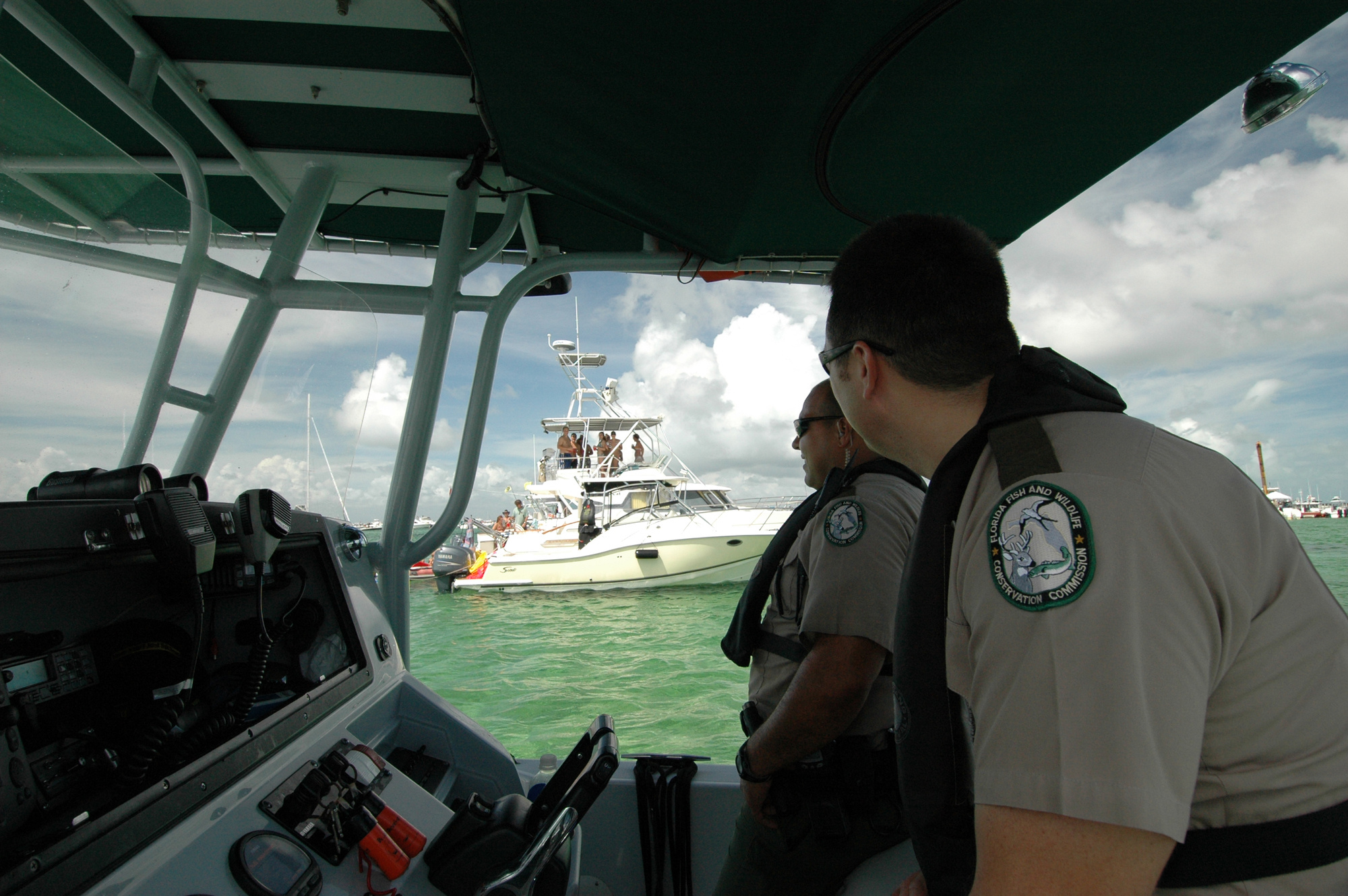
More words of wisdom from the Florida Fish and Wildlife Commission.
FWC promotes safe, sober boating this weekend for Operation Dry Water
The Florida Fish and Wildlife Conservation Commission (FWC) will be working to keep waterways safe this weekend.
During the national Operation Dry Water campaign officers will focus on removing impaired operators from the water and educating boaters about safety.
The Fourth of July holiday is one of the busiest boating holidays all over the U.S., including here in Florida. There are over 950,000 boats registered in the state and an estimated 1 million additional non-registered boats enjoying Florida’s waters.
Boaters should know that operating a vessel under the influence of alcohol or drugs is illegal and can lead to serious injuries and consequences. In Florida, it is illegal to operate a vessel with a blood alcohol content level of .08 or higher – the same as it is to operate a vehicle.
“As law enforcement, it is our job to do all we can to ensure the safety of our recreational boaters and paddlers,” said Maj. Robert Rowe, FWC’s Boating and Waterways Section Leader. “The accidents and tragedies that happen because individuals choose to drive impaired, on land or on the water, are preventable. We’re joining other agencies across the country to keep boaters safe and prevent accidents related to BUI.”
If a person decides to take alcohol on their voyage, it is important to designate an operator who isn’t drinking alcohol and will remain sober to ensure everyone gets home safely. The FWC encourages boaters to enjoy the boating season to its full extent by boating sober, wearing a life jacket and taking a boating education course.
Although this guide is aimed primarily at RVers, many of you have access to land transportation when in port, so read and enjoy. Our thanks to Joey Miller of Jen Reviews for permitting Cruisers Net to share this information with you.
A number of waterfront communities offer fireworks displays over the 4th of July and graciously permit spectator boats to anchor nearby – always a great vantage point for viewing. However, please remember that the time immediately following the displays, is a very dangerous scenario when party boats are weighing anchor and departing. Your night vision is usually disrupted by the bright lights and alcohol is often involved. The situation requires slow speed and sharp lookout. Please get back to your homeport alive!
As you fuel up this holiday weekend, keep an eye out for flame in any form on the fuel dock. As a longtime friend of Cruisers Net relates, dock hands are not exempt from safety guidelines. Do not hesitate to speak up!
I do not want to post publicly any unfavorable comment, but filled up at [ICW marina] in Georgia over the weekend and as I finished filling my gasoline tanks and put up the fuel hose the dock-master on site walked down on the gas docks, cigarette dangling from the mouth. It got MY attention.
Share:
Comments from Cruisers (1)
james- July 5, 2019 - 4:59 pm
Saw same thing at Fernandina Beach City Marina, staff hanging on the fuel pump while we filled up, cigarette in hand!!


Be the first to comment!