Gateway to the Gulf Newsletter |
|
Highlighted Events/Classes this Week |
|
| Seated Tai Chi Tuesday, April 16th at 8 a.m. Thursday, April 18th at 8 a.m. |
Gulfport Senior Center Tai Chi Attire: Wear comfortable clothing, & flat soled shoes. Bring water, if you like. |
|
| Seasoned Sowers Garden Club Tuesday, April 16th 9 a.m. Gulfport Senior Center |
|
| Fresh Market Tuesday, April 16th |
Every Tuesday 9 am – 3 pm Gulfport Fresh Market on Beach Blvd. S. The Gulfport Tuesday Fresh Market, located along Beach Blvd. in Gulfport’s Historic Waterfront Arts District, is open year-round, from 9 am – 3 pm. With a roster of over 70 vendors, you will find a wide variety of products, including but not limited to, ready-to-eat and take-home foods, fresh produce, plants, herbs, jewelry, teas, art, clothing and live music. |
|
| Ballroom Dance Tuesday, April 16th |
with Carol Baker Gulfport Casino Ballroom 12 pm – 3 pm $8.00 admission Call 727-798-3660 |
|
| Texas Hold’em Tuesday, April 16th at Noon Friday, April 19th at Noon |
|
| Argentine Tango Dance Tuesday, April 16th |
with Kathleen & Steve Prucher Gulfport Casino Ballroom 6:30 pm – 11 pm $8.00 admission Call 727-742-3368 |
|
| City Council Meeting Tuesday, April 16th |
7 p.m. Gulfport City Hall |
|
| Spring Fling Wednesday, April 17th 2 p.m. Gulfport Senior Center |
|
| Laughing Yoga Wednesday, April 17th |
with Certified Laugh-a Yoga Leader, Cathleen Howard 3:30 p.m. Scout Hall |
|
| Gulfport Toastmasters Wednesday, April 17th |
Gulfport Public Library Social: 6:00 to 6:15pm Meeting: 6:15 to 7:30pm |
|
| Sound Meditation Thursday, April 18th |
|
| Chair Volleyball Thursday, April 18th |
2:30 p.m. Gulfport Senior Center |
|
| Latin Night at the Gulfport Casino Thursday, April 18th |
6:30 – 11 p.m. Doors Open at 6 p.m. $8 admission Gulfport Casino Ballroom |
|
Gulfport Community Players present: The Octette Bridge Club Thursday, April 18th 8 p.m. Catherine Hickman Theater The Octette Bridge Club is a sentimental comedy that let us listen in on eight matronly Irish Catholic sisters who meet every other Friday to play cards and swap gossip. The story ultimately focuses on the oldest, the domineering Martha, and the youngest, the high-strung and emotional Betsy. Set in the l 930s it’s a charming play about American life in a bygone era. April 18-28 Thur-Fri-Sat@ 8PM Sat & Sun@ 2PM Tickets $18 online and at the Gulfport Beach Bazaar Tickets $20 lobby (one hour before showtime, cash only) |
|
Porch Party: Gulfport Trolley Friday, April 19th 7 – 10 p.m. Trolley Market Square 49th St. S. & Tangerine Ave. S. Getting Gulfported: How the trolley brought people to Gulfport — and beyond Celebrate the official dedication of Trolley Market Square as an historic site in Gulfport. The Gulfport Historical Society will have kids activities, live music from the Urban Gypsies, and they’ll unveil the new historic marker and their brand-new walking tour. Co-sponsored by the City of Gulfport and the Gulfport Merchants Association. The event is a part of the 5th Annual SunLit Festival running April 11-28, 2019. For more info on SunLit: www.sunlitfestival.org. For more information, contact Cathy Salustri, 727-656-5420 |
|
Sock Hop with the Impacs Friday, April 19th 7 – 10 p.m. Gulfport Casino Ballroom Step back in time as you dance to the sounds of the 50s and 60s with the legendary Impacs. The Impacs will host their next performance of the 2019 season at the Historic Gulfport Casino Ballroom on Friday, April 19, 2019. Tickets, in advance, are two for $25, or $15 each and available at the Gulfport Casino Box office, 5500 Shore Blvd S. or the Downtown Beach Bazaar at 3115 Beach Blvd. S. Originating in the 1960s, the Impacs are celebrating their 57th anniversary by taking you back to the days of Sock Hops, Star Spectaculars, and American Bandstands. The fun begins the night of the show with doors opening at 6:30 p.m. and live music starting at 7 p.m. Admission at the door, the night of the show, is $20 per person. Tickets are on sale now at the Gulfport Casino Ballroom box office or Gulfport Beach Bazaar. For more information, please call the Gulfport Casino Ballroom at (727) 893-1070. |
|
| Fun in the Sun Day Saturday, April 20th 10 a.m. – 12 p.m. Gulfport Recreation Center 5730 Shore Blvd. S. For more information, please contact 727-893-1068. |
|
Third Saturday Art Walk Saturday, April 20th 6 p.m. – 10 p.m. Visit Gulfport Florida on Saturday, April 20, for the Gulfport Art & Gallery Walk. Find your shopping and dining maps at VisitGulfportFlorida.com and chart your course to our beachfront town! Shop for local art along Beach Blvd, visit a gallery, catch a live local band and dine at one of the locally owned restaurants along Beach & Shore Blvd’s. The Gulfport Art & Gallery Walk event, produced by the non-profit Gulfport Merchants Association, takes place from 6-10 p.m. every first Friday and third Saturday – rain or shine, all year round, and is home to dozens of artisans and craftsmen each month. There is never an admission fee for visitors and complimentary parking is available nearby with courtesy trolley rides available to and from off-site parking areas. Gulfport events are always pet and family friendly. GPS – 3101 Beach Blvd. S., Gulfport, FL 33707. |
|
| Healthy Cooking Class Monday, April 22nd 3 p.m. Gulfport Senior Center 5501 27th Ave. S. |
|
| TEDTalks Monday, April 22nd 5:30 p.m. Gulfport Senior Center 5501 27th Ave. S. |
|
| Gulfcoast Legal Services Tuesday, April 23rd 1 – 5 p.m. Gulfport Senior Center 5501 27th Ave. S. |
|
| Gulfport Lions Club Monthly Meeting Tuesday, April 23rd |
6 p.m. Social / 6:30 p.m. Dinner Gulfport Lions Club 4630 Tifton Dr. S. Second & fourth Tuesday’s every month |
|
| Health Tips & How to be Unstoppable at any Age Wednesday, April 24th 2 p.m. Gulfport Senior Center 5501 27th Ave. S. |
|
| Stetson Area Neighborhood Watch Meeting Wednesday, April 24, 2019 Eleazer Hearing Room 1401 61st St. S. 7:00 p.m. All meetings start at 7:00 p.m. and ANYONE CAN ATTEND! Contact Jim Wright, Volunteer Coordinator at: 727-893-1022 |
|
| Introduction to iPad & iPhone Thursday, April 25th 1:30 p.m. Gulfport Senior Center 5501 27th Ave. S. |
|
| Book Club Friday, April 26th 9:30 a.m. Gulfport Senior Center 5501 27th Ave. S. |
|
Spring Fest Garden Art & Faerie Festival Sat. & Sun., April 27 – 28 10 a.m. – 5 p.m. Clymer Park The Gulfport Area Chamber of Commerce will host its 25th Annual Spring Fest Garden Art & Faerie Festival along the green and tree-covered expanse of Gulfport’s 7.5-acre Clymer Park, on April 27 – 28, 2019. The Garden Art & Faerie themed festival will transform the park into an “enchanted village” inhabited by costumed faeries, sprites, gnomes, ogres and trolls. Renaissance-era characters, gypsies, minstrels, wizards and roving entertainers in costume will also stroll through the event. Spring Fest will offer a wide variety of family friendly activities and entertainment. Favorite activities such as May pole dances, a faerie house contest, costume contests and live music will be returning. A children’s area will offer activities including face painting, pixie dusting, bubble blowing, and more. Vendors offer plants, garden art, flowers, herbs, Renaissance-period items, clothing, jewelry, art, hand-made crafts, food & beverages, and other items of whimsical interest. There is no admission fee for the pet and family friendly event, and complimentary parking is available with gratis trolley rides to and from off-site parking areas. |
|
| Art Show & Reading Monday, April 29th at 3 p.m. Widow, a solo journey forward a new work by Kate Seidman Gulfport Senior Center 5501 27th Ave. S. |
|
| Pinellas County Solid Waste Master Plan Workshop Monday, April 29 6 p.m. – 8 p.m. Gulfport Casino Ballroom 5500 Shore Blvd. S. |
|
| City-Wide Neighborhood Watch Meeting Wednesday, May 1, 2019 Gulfport Neighborhood Center 1617 49th St. S. 7:00 p.m. All meetings start at 7:00 p.m. and ANYONE CAN ATTEND! Contact Jim Wright, Volunteer Coordinator at: 727-893-1022 |
|
| 1st Friday Flea Market Friday, May 3rd 9 a.m. – 12 p.m. Gulfport Senior Center 5501 27th Ave. S. |
|
| Goodwill Hippie Dash Saturday, May 4th May the Groove be with you! 7:45 – 11 a.m. Downtown Gulfport Waterfront District For more information, please visit |
|
| Comedians Uncorked Saturday, May 4th 7 p.m. Catherine Hickman Theater 5501 27th Ave. S. To purchase tickets, please visit |
|
| City Council Meeting Tuesday, May 7th |
7 p.m. Gulfport City Hall 2401 53rd St. S. |
|
| Marina District Neighborhood Watch Meeting Wednesday, May 8, 2019 Lions Club 4630 Tifton Dr. 7:00 p.m. All meetings start at 7:00 p.m. and ANYONE CAN ATTEND! Contact Jim Wright, Volunteer Coordinator at: 727-893-1022 |
|
Soul Night w/ Swing Time Friday, May 10th at the Gulfport Casino. Dance 8pm-midnight to the best in Funk, Soul, Disco, Motown, Rhythm & Blues, featuring an exciting mix of retro & modern dance music, great for a variety of partner dances (Hustle, Swing, West-Coast, Blues, Fusion, etc) plus group, line, and freestyle dancing! Arrive early for a Rumba Lesson 7-8pm. Just $10 includes the dance AND the lesson. Students get $6 admission if they show up by 7pm and take the lesson. Soul Night happens at the Gulfport Casino the 2nd Friday of every month. Lesson Info — Learn Soul-style Rumba…how to Rumba to Soul music! This class, taught by Sam from Swing Time, will broaden your musical dance skills, so you’re no longer limited to boogying back & forth between two feet. A surprising number of soul, funk, blues, and R&B tunes, including many of your favorite songs, have a slow-quick-quick rhythm that’s perfect for dancing Rumba, and we’re going to dance to a variety of these songs in the lesson. In addition to typical Rumba moves, we’ll learn some new ones, borrowed from other dances. For experienced dancers, we’ll show you how to convert your entire repertoire of Salsa, Bachata, and Cha Cha moves to Rumba dancing! If you like dancing to Soul, Funk, Blues, or R&B music, including live bands, then you’ll enjoy adding Rumba to your repertoire. |
|
| Junk in the Trunk Saturday, May 11th 8 a.m. – 1 p.m. 49th Street Neighborhood Center 1617 49th St. S. |
|
| Monthly Beach Cleanup Saturday, May 11th 9 – 11 a.m. Gulfport Beach, Shelter #4 |
|
Art Opening and fundraiser Saturday, May 18th 6 – 10 p.m. Gulfport Art Center 2726 54th St. S. Abstract Art for Autism and other Special Abilities by Studio Duvoe, Inc. Come help us celebrate the creative genius of these awesome special abilities young people & adults. When a student sells a painting they receive ½ of the funds with the other half funding future art workshops and openings. All artwork is nicely framed and reasonably priced ($10 – $50). Volunteers and donations are always welcome. Contact Caroline Duvoe (727-271-5016) or Dan Mlotkowski (727-331-3819) for questions or details. Live music by Kari Kane and Those Lovebirds (Marty Fouts & Bonnie Kesler-Fouts). Drop by for a wonderful evening of live music and art in support of a wonderful organization. |
|
| City Council Meeting Tuesday, May 21st |
7 p.m. Gulfport City Hall 2401 53rd St. S. |
|
| Memorial Day Monday, May 27th All City Facilities Closed |
|
| City of Gulfport Hurricane Preparedness Seminar Thursday, May 30th - Doors open at 6 p.m. for Hurricane related vendor information
- Seminar featuring Chief Meteorologist Bobby Deskins and Emergency Management Director Cathie Perkins begins at 7 p.m.
Catherine Hickman Theater 5501 27th Ave. S. |
|
For more information and to register for the parade, please visit |
|
Gulfport Little League Club Gulfport Little League Club, Inc. Trevor Mallory, President 4501 6th St. S., St Petersburg, FL 33705 Old League with a new Attitude, new Leadership and growth Vision for Youth Baseball! Come out and watch a game! Cheer our youngsters on! This week’s home games are: - Thursday, April 18, 6:30pm @ Tomlinson Field,Minors Machine Pitch v Cross Bayou
- Saturday, April 20, 9:00am @ Hoyt Field, Softball Coach Pitch v Pinellas Park
|
|
New Scholarship for LGBTQ Gulfport Student The LGBTQ Resource Center at Gulfport Public Library is proud to announce it is offering a $1000 scholarship for the continuing education of an LGBTQ student from Gulfport. The Resource Center’s inaugural LGBTQ Scholar Award is intended to help students continue their post-graduate education, whether in college or trade school. Applicants must be at least 16 years of age and have completed high school by June 2019. They must have a home address within the last two years in Gulfport and be currently accepted to or already attending an accredited post-secondary institution. Finally, applicants must be registered for full-time attendance in the fall of 2019 in an undergraduate, graduate or trade school program. Completed applications must be received by June 3, 2019. Reference letters are due no later than June 10. Please direct questions to Susan Gore, c/o LGBTQ Resource Center, Gulfport Library or at susangphd@gmail.com. |
|
Call for Applicants for its 2019/2020 “Rise and Shine” Grants for eligible artists currently residing in Pinellas County The Gulfport Merchant’s Chamber (GMC) has announced a call for applicants for its 2019/2020 “Rise and Shine” Grants for eligible artists currently residing in Pinellas County. The purpose of the grants is to support Gulfport’s and Pinellas County’s creative community and to promote Gulfport as an art destination. Preference will given to artists residing in Gulfport. Applicants must be 18 years of age or older. Two grants, including funding, marketing/advertising support, and exhibition space will be offered with a total value of $1000 each. Deadline to apply is July 31. Each grant includes $500 up front to be used exclusively for displays, materials and supplies related to the artist’s aspirations; $300 in 10 paid booth reservations at the twice monthly Gulfport Art and Gallery Walks within a one-year period, with direct professional social media and marketing support; quarterly mentorship with a professional artist board member and one-on-one consultations with the art committee throughout the year; and $200 after completing 10 events and a post grant report. All grant monies are expected to go directly into the artist creating work and creating a professional display that can be used for future festivals and shows. |
|
Call for Applicants for its 2019/2020 Community Support Grant Program The Gulfport Merchant’s Chamber (GMC) has announced a call for applicants for its 2019/2020 community support grant program. Local non-profit organizations that target or include Gulfport in their activities are invited to apply. Applicants must be certified tax-exempt non-profit organizations, government entities requesting funds for public purposes, or schools and colleges at any level. For more details and to apply, see the application available at www.VisitGulfportFlorida.com. Click on “Community Grant” at the bottom of the home page. Submission of an application does not guarantee funding and the Board of the GMC reserves the right to determine or adjust the amount awarded to any recipient. Applications must be received in writing and must be emailed, postmarked or delivered no later than March 31, 2019. Applications received after the deadline cannot be considered. Decisions on recipients are scheduled to be announced by April 27. Special consideration will be given to organizations that are able to help promote and provide volunteers for the GMC events that raise the funds making these grants possible. “Gecko World” events with funds earmarked each year for community giving include “Gecko Crawl,” “Gecko Ball” and the GeckoFest street festival. The events grow in size and popularity every year and each requires a large promotional effort and a large number of volunteers. Grant amounts will be determined and funds distributed to grantees after these GMC events have concluded for 2019. Since sponsoring the community grants, the GMC has provided many thousands of dollars in funding to a large and growing roster of worthy non-profit organizations. The GMC also gives back to the community in other ways during the year, including sponsoring “Gulfport’s Get Rescued” each February, benefitting animal rescue groups. A monthly Clothing Swap benefitting CASA is held during the Gulfport Tuesday Fresh Market; and the GMC’s “Holiday Hoopla” helps collect donations for Operation Santa in December. Public art installations have also been commissioned and installed with GMC funding. |
|
| City of Gulfport’s FREE VPK Program Enrollment begins May 1st Classes start September 3rd Questions, please contact 727-893-1068 |
|
| Household Electronics & Chemical Collection Schedule All events are on Saturdays 9 a.m. – 2 p.m. call 727-464-7500. |
|
 | Online access to the City of Gulfport Municipal Code is provided at the following link: |
| |
|
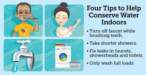
| Latest water quality information: |
|
For more information, please visit |
|
| Smoke Alarms Save Lives Free smoke alarms are available to elderly and low income households within Gulfport City limits. Call Fire Chief James Marenkovic at 893-1062 for more information. |
|
Gulfport on the Go! Get the City App City of Gulfport is proud to announce the launch of the new City of Gulfport app for iOS and Android mobile devices, the newest way to connect with its citizens. The Official City of Gulfport app offers citizens a simple way to submit requests-like reporting potholes, signs, trash or debris, code violations, and inquiring about an event venue. Users can include an address and description, GPS-specific location, as well as a photo of the issue. Once a request is submitted, you can keep track of pending and completed requests within the “My Requests” section. In addition, the City app has direct links to the online utility bill payment system, the City calendar, frequently asked questions, the city employee directory, the sanitation department, and the electronic newsletter signup. The City App allows residents to connect more conveniently with City government to report issues and request non-emergency services. Offering more ways for citizens to connect with the City, please email info@mygulfport.us or call 727-893-1118 with questions or technical issues about the smart phone app. |
|
Reassurance Telephone Program Gulfport Senior Center 5501 27th Ave. S. Let the friendly Volunteers of the Gulfport Senior Center chat with you on a daily basis. Sign up for the Gulfport Reassurance Program and choose between two call times: early-morning or mid-morning. This service is designed to help you feel secure and connected. For more information, call the Gulfport Senior Center at (727) 893-2237 |
|
FREE Amplified Phone Gulfport Senior Center 5501 27th Ave. S. 3rd Tuesday of every month 9:30 – 11:30 a.m. You MUST call 727-399-9983 to qualify. |
|
Two For One Sale at Circle Bookshop Gulfport Public Library 5501 28th Ave. S. Fans of Nora Roberts and Fern Michaels check out the sale cart at the Circle of Friends Bookshop at the Gulfport Public Library. Barbara Taylor Bradford and Debbie Macombe are also well represented. Special two for one sale carts through the end of December. Be sure to look at the award winning books and the 2017 and 2018 best sellers. Books make a great holiday gift and the bookshop has fiction and non-fiction titles galore. If a crafter or cook is on your gift list, you can find the perfect book at the bookshop. The Circle of Friends Bookshop is located in the Gulfport Library, 5501 28th Avenue S. Please call Marilyn Field at 727-321-4035 if you have any bookshop questions. |
|
2020 Census: How to Get Involved The 2020 Census provides an opportunity for everyone to be counted. Tribal, state, and local governments; community based organizations; faith-based groups; schools; businesses; the media; and others play a key role in developing partners to educate and motivate residents to participate in the 2020 Census. When community members are informed, they are more likely to respond to the census. Through collaborative partnerships, the U.S. Census Bureau and community leaders can reach the shared goal of counting EVERYONE in 2020. The Complete Count Committees (CCC) program is key to creating awareness in communities all across the country. - CCCs utilize local knowledge, influence, and resources to educate communities and promote the census through locally
- based, targeted outreach efforts.
- CCCs provide a vehicle for coordinating and nurturing cooperative efforts between tribal, state, and local governments; communities; and the Census Bureau.
- CCCs help the Census Bureau get a complete count in 2020 through partnerships with local governments and community organizations.
WHO? Tribal, state, and local governments work together with partners to form CCCs to promote and encourage response to the 2020 Census in their communities. Community-based organizations also establish CCCs that reach out to their constituents. WHAT? A CCC is comprised of a broad spectrum of government and community leaders from education, business, healthcare, and other community organizations. These trusted voices develop and implement a 2020 Census awareness campaign based upon their knowledge of the local community to encourage a response. WHEN? The formation of CCCs is happening NOW! Leaders are identifying budget resources and establishing local work plans. In 2020, they will implement the plans and lead their communities to a successful census count. HOW? It’s up to all of us! CCCs know the best way to reach the community and raise awareness. Some activities could include: - Holding CCC kickoff meetings with media briefings.
- Participating in Census rallies or parades.
- Coordinating Census unity youth forums.
- Hosting Interfaith breakfasts and weekend events.
- Encouraging the use of Statistics in Schools classroom resources.
- Incorporating census information in newsletters, social media posts, podcasts, mailings, and websites.
- Helping recruit census workers when jobs become available.
WHY? The primary goal of the 2020 Census is to count everyone once, only once, and in the right place. Community influencers create localized messaging that resonates with the population in their area. They are trusted voices and are best suited to mobilize community resources in an efficient manner. Earn extra income while helping your community. |
|
|
|
|
|
|


Be the first to comment!