Shared Photo – Captiva Sunset
Greg Allard shares a photo of the beautiful sunset on Captiva Island, FL.

Captiva Sunset, Captiva Island, FL by Greg Allard
Greg Allard shares a photo of the beautiful sunset on Captiva Island, FL.
Captiva Sunset, Captiva Island, FL by Greg Allard
Sadly, as Steve Ramsay bewails, what seemed unthinkable ten years ago is now a reality, not only in Florida, but along much of the east coast: free, public anchorages are becoming pay-for-use municipal mooring fields. (Enter “mooring” in the Search window above for a perspective on the battle that was waged against mooring fields in Florida several years back.) While welcomed by some who see the moorings as an alternative to ever rising dockage fees, those of us who boat on a budget and find the moorings restrictive, along with the prohibitive cost of boating in general, are in agreement with Steve, to the point that we can no longer afford to spend much, if any, time cruising. Steve is replying to A Disturbing Message about Anchoring.
Like so much of our culture today, it is a case of the “HAVEs” versus the “HAVE NOTs.” We hear you Steve!
I moved here from New England and as a boater since age 2, I am very disappointed with the availability of moorings here (Tampa area). Boating is such a healthy outdoor activity for the whole family. Go to New England, you will see boats on moorings as far as the eye can see, and they only have a 4 month season. I had planned on buying a 24 ft. sloop, but I am afraid I will have to abandon the idea altogether. Personally, at $400 per month for a mooring, I am forced to leave my favorite past time to a high end class of people who will continue to enjoy sailing as much as I did. I have been priced out. It seems like boating here is discouraged rather that encouraged and fully advocated for.
It seams to me that the big marinas are really controlling the cost of docking more so than ever, in St. Petersburg the safe harbor group will get control of the city docks soon, that means they have a monopoly controlling all the docks and moorings in St. Petersburg.
As for anchoring I don’t have any problems with this except that Most anchorage’s have bad boat that are in kept and in danger of abandonment also there is a problem with pumping out this is a federal regulation that is always over looked
Anchorage for transit moorings and dingy docks is a good idea for everyone at a minimum price if not totally free.
You are absolutely correct,Steve. I traveled in a trawler from North Carolina to Louisiana for many years and enjoyed the many towns and anchorages along the way. Not nearly as many anchorages as there used to be. And many more restrictions on the ones that are left. Florida, especially , seems to discourage boating. Especially transient boating. I got tired of the hassle and high cost of marinas, moorings, and dockage and got out of boating. It’s not affordable for the average pocketbook anymore. It’s just one more thing that belongs to the people with a lot of money. The middle class will soon be no more.
My opinion,
Jerry
A CRUISERS’ NET SPONSOR!, Downtown Marina is located north of AICW marker #239, a short distance west of the Lady’s Island swing bridge, in the heart of downtown Beaufort. Our thanks to Charlie and Jackie for these good words.
9-20-18. Over night at Downtown Marina at Beaufort. As usual terrific spot. Deck hand Troy- very experienced and nice- helped with lines. On inside of face dock. Bath house nice, decent ships store. And the most very nice ladies that take reservations are in the store. Pleasure to deal with. Always a must stop- especially with all the restaurants, shops, etc all so close. There is a new day dock- just for transients to tie up for lunch, etc. Very large and substantial– even looks nice. Good wifi and many air tv channels, but they also have cable.
Charlie and Jackie on Traveler
Click Here To View the South Carolina Cruisers’ Net Marina Directory Listing For Downtown Marina
Click Here To Open A Chart View Window, Zoomed To the Location of Downtown Marina of Beaufort
Our thanks to the Seven Seas Sailing Association for this detailed report. NOTE that Socastee Swing Bridge at mile 371 south of Myrtle Beach is closed due to high water, see NAV ALERT. And note that conditions are changing on a daily basis, so stay connected to an active site like Cruisers’ Net for up to the minute news.
Post-Florence news for those cruising in the Eastern U.S.
Both North Carolina and South Carolina suffered and continue to suffer ongoing flooding damages. As of Sept. 20th, 2018, two ICW bridges in Virginia south of the Atlantic Yacht Basin opened for marine traffic, the Centerville Turnpike Bridge and the North Landing Bridge.
This now allows transit from Elizabeth River to Beaufort/Moorhead City, NC via the major ICW route. Vessels that had been collecting at anchor or marinas up the Elizabeth River/Hampton or at the basin are now able to head down the ICW to Beaufort and points south. Boats at Coinjock, where many sheltered from Hurricane Florence, are now moving to Beaufort as well; the ICW waterway is likely to be crowded.
Many areas south of Beaufort, NC, where flooding occurred/is ongoing, are in recovery. Oriental just got power to the marinas in the last day or so, as of Sept. 20th. However, due to the fact fuel pumps and tanks require power, as well as EPA certification to re-open, it will be on a case-by-case basis for fuel availability; at least four more days for Oriental Marina and Inn, who usually has fuel for boaters.
There may be some slips, but high water caused damages. Whittaker Pointe Marina is open with some slips/without fuel, but again, call ahead. Pungo River showed major flooding (water up to windows on buildings), so checking in that area is critical.
As to fuel, Beaufort Docks have fuel and slips; making slip reservations are advised, though. Many boats are leaving from that location heading to Charleston, SC as their next stop. Common sense suggests the ICW will be impacted by floating debris, so night travel is certainly not advised; offshore is possible with great care. At all times, manning the helm with eyes visually scanning the water during passage is critical. Some inlets are likely shoaled, and the information is limited until the USCG checks out buoys and depths.
Osprey Marina in Myrtle Beach, SC is open and has fuel, per their dockmaster as of September 20, 2018. So, if a jump to Charleston, SC is too far, stopping in Myrtle Beach could be an option for fuel needs.
For those boats heading south to the Chesapeake Bay, the various lower bay marinas are open and fuel is available; it’s business as usual. Newly dredged to 8+ feet Saltponds Marina has slips and fuel, as does Bluewater Marina, Old Point Comfort, Cobbs Marina, Tidewater Marina, Norfolk Waterside, Portsmouth Public Docks, Ocean Yacht Marina, and Atlantic Yacht Basin to name a few. Mill Creek Anchorage at Fort Monroe near Old Point Comfort YC has a new floating dinghy dock just completed; this allows anchored vessels to tie up their dinghies on the main street of Phoebus, with easy walking to local eateries and grocery stores. Car parking is available nearby. No damage was experienced only minor flooding; marinas/anchorages are all open and fuel is available.
Top Rack Marina is an additional marina in the Chesapeake, Virginia area (just around the corner from the entrance to Dismal Swamp Canal) on the Elizabeth River. 11 Slips available for $35 (fixed price) on first come first served basis. Economical diesel and gasoline prices as well. Draw back is only the first 5 slips have power, and no water directly at the slips (but available at the fuel dock). No services near by, but good restaurant on site. Uber available in the area.

The New Bern Grand Marina, A CRUISERS’ NET SPONSOR, lies in the heart of downtown New Bern, North Carolina, along Trent River’s northern banks between Trent River highway and railroad bridges. New Bern took a direct hit from Florence and the community has experienced extensive flooding.
Also, all ramps to the docks have now been repaired. All docks are accessible and now also have water.
Jeremy McConnell
Click Here To Open A Chart View Window, Zoomed To the Location of New Bern Grand Marina
Our thanks to Bill Parlatore for permitting Cruisers’ Net to post articles from his excellent blog, Following Seas.

Time to Think About Going South
It’s an exciting time of year to begin planning for the fall trip south. So many choices, so many new things to see, it is a wonderful experience.
While flooding in the Waterway might solve some depth issues, it creates an entirely new set of problems: off-station markers, shifted channels – especially at inlet/ICW intersections, floating and submerged debris washed from shore, swift currents in normally calm waters, etc. If you are navigating in the upper South Carolina and North Carolina ICW, use great caution and TAKE YOUR TIME! And remember, your wake may be washing into someone’s living room!
FIRST ALERT: Intracoastal Waterway flooding now forecast to surpass Matthew record
WMBF
Here is when and where forecasters say the Waccamaw, Little Pee Dee Rivers will crest
Myrtle Beach Sun News
Please advise how flooding of Intercoastal Waterway flooding will impact Brighton Woods subdivision?
A fine article from BoatUS on vessel recovery.
BoatUS: How to Recover Your Boat After a Hurricane
BoatUS Catastrophe Team salvage operations begun
Our sincerest thanks to Tom Hale for sharing this detailed look at Waterway conditions following Hurricane Florence in North and South Carolina.
Sept. 17, 2018
As previously suggested and as hoped, the Northern part of the ICW between Norfolk and Beaufort NC is partially operational. Some facilities are fully up and running. Some facilities are damaged but running. Some facilities are closed. However the ICW seems passable with dockage, fuel and water available in places between Norfolk and Beaufort, NC. Those facilities which are open for business are anxious to have cruisers come through. But be aware that many homes and businesses are flooded and already damaged. Be even more careful about your wake, as in flooding conditions your wake is hitting homes and yards. The ICW south of Georgetown SC is operating normally.
But that 125 miles between Beaufort, NC and New River (Myrtle Beach) is still flooding, is lacking electrical power and phone lines, and is several days away from being able to fully report, and weeks or months from being back to normal water levels.
Never mind my earlier post. Let’s try again:
Do we have a closer timestamp on the observation of the Wilkerson Bridge?
Thank you for this report. Was the clearance reported for the Wilkerson Bridge adjusted to MHHW?
Good advice for all ICW property owners from Georgia’s DNR Coastal Resources Division.

Was your beach front property, private dock, bank stabilization, marina, commercial dock, or other structure within coastal waters, marshlands or along barrier island beaches impacted by Hurricane Matthew?
Emergency Repair of Structures in Tidal Waterways, Over Marshlands and Along Shorelines
• Secure any structures that pose safety or health concerns immediately
• Call the Georgia Emergency Response Team at 1-800-424-8802 to report a fuel or oil spill
• Remove any debris from marshes, beaches and waterways that originated from your structures to the extent practical and safe
• Take photos to document damage from Hurricane Matthew
• Compile any documents, permits, and photos to show the pre-storm condition of the structure
• Call DNR/CRD at 912-264-7218 to report the need to rebuild damaged structures
• In order to be eligible for emergency authorization, you must make a request by Wednesday, November 2, 2016
• CRD staff will call back within 1-2 business days with guidance or verbal approval for repairs pursuant to state law
• Emergency authorizations will be limited to repair of structures in their original location and in their original size and configuration
• Some repairs may require authorization from the U. S. Army Corps of Engineers and/or local authorities. CRD staff will provide guidance based on the extent of the damage and location of the structure.
• Non-essential projects currently under review and new permit applications for non-essential projects are temporarily suspended until emergency requests are addressed
DNR Responds to Impacts of Hurricane Matthew
Our thanks to Bill Parlatore for permitting Cruisers’ Net to post articles from his excellent blog, Following Seas.
Monday Minute – What A Wild Week!
These three anchorages lie off the ICW between the Waterway/Ashley River intersection and the Hwy 17 bascule bridge several hundred yards up the Ashley. See Observations for further comments. Our thanks to Robert Pease for this warning!
I was warned by the marina of a lot of crap on the bottom. My anchor got fouled on long lengths of scrap electrical cable. You may want to put a note of caution on this anchorage. Am currently up the Wando river, very good holding.
Robert Pease
SV Journey
Click Here To Open A Chart View Window, Zoomed To the Location of Charleston/Ashley River Anchorages
Click Here To Open A Chart View Window, Zoomed To the Location of Charleston City Marina
Our thanks to Rebecca Maxwell for this report and anchorage recommendation. The Bingham Islands mentioned as a possible anchorage are on the eastside of the ICW immediately south of the bridge. Flagler Memorial. Royal Park and Southern Blvd bridges were under schedule deviations earlier this year. See Directory Listing below for background information.
Bridge is under construction. Clearance is 65’ at lo tide and variance can be 3+’. Bridge openings are on :15 and :45. Our 63’ mast kept us on the southside awaiting low tide. We anchored overnight in 7’ just north of a small cut off Bingham Island. We were far enough out of the waterway for traffic and the holding was good. If you get caught on the southside of this bridge waiting for the next opening, this is a welcome anchorage.
Rebecca Maxwell
Click Here To Open A Chart View Window Zoomed To the Location of Southern Blvd Bridge
The temporary bridge will have a vertical clearance of 14 feet in the closed position and 65 feet in the open position with a 125-foot wide navigable channel. The bridge will maintain an opening schedule of twice per hour at 15 minutes and 45 minutes past the hour. There may be half-channel closures during construction.
Subject line should read “Southern Blvd Bridge” And this is a temporary lift bridge, with two vertical clearance distances — one in the down position and one in the up position. See photo in website link below
The Cape Coral Cruise Club is a group of dedicated cruisers who always provide unique reports from the marinas they visit. Pink Shell Beach Resort and Marina, A CRUISERS’ NET SPONSOR and voted Best Small Marina in 2017, overlooks the westerly banks of the Matanzas Pass channel, west of marker #13. Pink Shell Beach Marina is a favorite of the CCCC, see https://cruisersnet.net/170308.
By Joanne Ziemer
An even dozen! That’s the number of boats that took advantage of the $1/ft. marina fee for our summer cruise to Pink Shell! Jeff & I settled in ahead of the arriving boats on Tuesday morning. Dave and Craig from Pink Shell were there to greet us in their usual cordial manner. Boaters arrived over the next several hours so, by Docktail time, we had a nice crowd gathered on the lawn for adult beverages and heavy hors de oeuvres. We were fortunate not to have the normal summer afternoon thundershowers.
Thanks to Michelle & Doug Rhees, and Becky & John Todd, Wednesday morning we served up a breakfast of sausage, eggs, fruit, sweet breads, and juice on the deck. It was HOT even at 8:30 a.m. but a few people found shade to enjoy their coffee and breakfast. After clean up, it seemed to be pool time for some folks. The wind was still out of the East, so no one was bothered by the effects Red Tide.
One group rented a pontoon boat for a leisurely cruise to a nearby restaurant for lunch. Others retreated to their boats for some “down time” or took the opportunity to just visit, and some headed to downtown to browse the many shops of Ft. Myers Beach. At 6 p.m., we reconvened for dinner on the lawn. It was again a concerted effort from my helpers who served up burgers and dogs along with the many varied and delicious sides our boaters brought! We had the 12th boat arrive today plus six folks by car so a total of 30 people for our BBQ! Again, the storms held off so no one got wet!
Thursday morning was a repeat of Wednesday. The temperature did not moderate, so another hot day was in store for us. Unfortunately, the wind shifted to the West, so even at the pool, we could feel the effects of Red Tide. No one stayed for a long time at the pool, most wandered back to the marina for some down time before gussying up for dinner. Tonight folks were on their own for dinner, and several headed to Fort Myers Beach to a favorite restaurant.
The last day of the cruise found all but four boats heading home. We were very fortunate with the weather this cruise. Although we had storms all around us, we did not experience any for the duration of the cruise. (For those of us who stayed Friday night; well, that’s another story!)
Thanks to all the participants! I know the staff at Pink Shell was pleased to have 12 boats nearly fill the marina!
The Cape Coral Cruise Club is open to new members who own a boat with overnight accommodations and reside in the Cape Coral / Ft. Myers area. For membership information please contact Phil Kryger at 239-541-0236. Read additional Club information on its website, www.c-c-c-c.org Like us on Facebook.
Click Here To Open A Chart View Window, Zoomed To the Location of Pink Shell Beach Resort and Marina
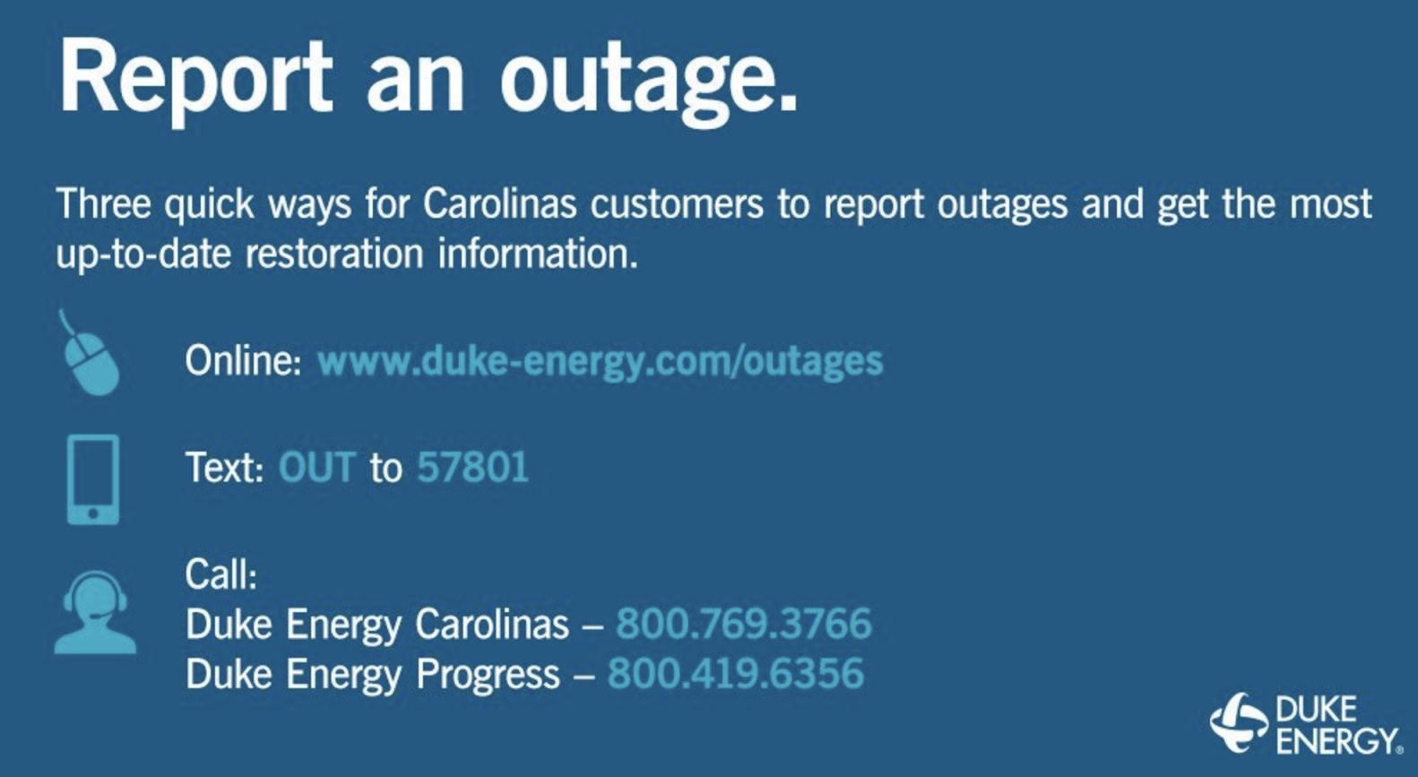
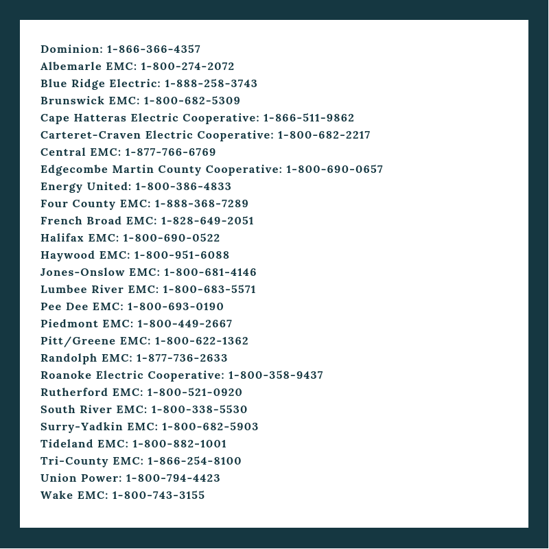
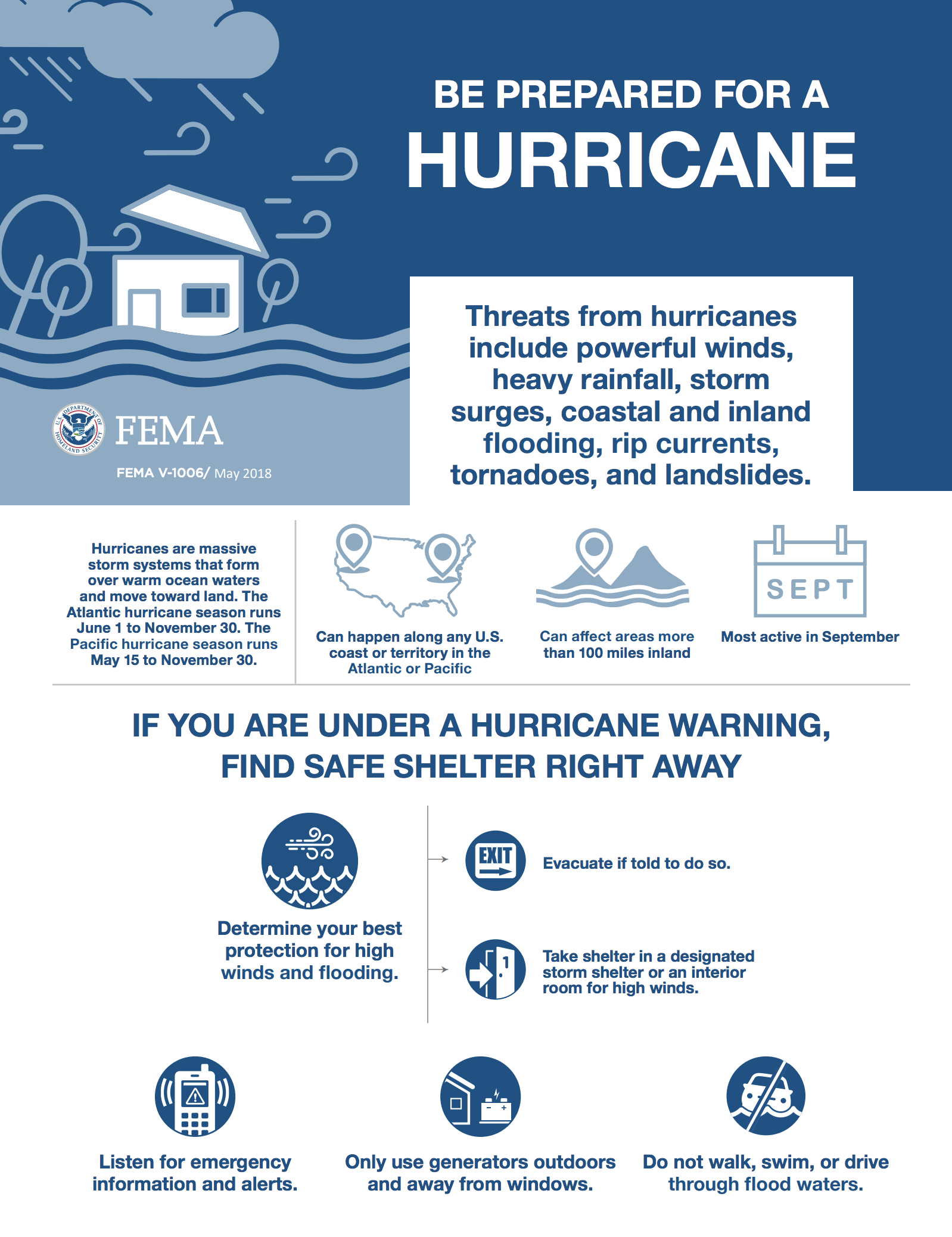
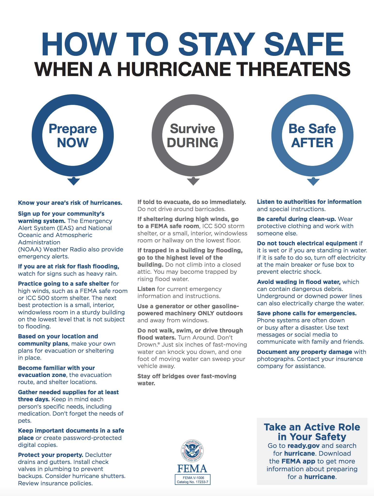
EMERGENCY RESOURCES IN SOUTH CAROLINA
SCETV
| ||||
|
Our thanks to Bill Parlatore for permitting Cruisers’ Net to post articles from his excellent blog, Following Seas.
Prepare For The Coming Storms by Bill Parlatore
Get ready for some nasty storms on the U.S. East Coast. Pam Wall shares some good information about how best to prepare. And take these storms seriously.

Great Bridge Bridge – Now Open
Katrina Greenwood
Drifting sands/shoaling will change inlets and on the ICW, creating maps to be inaccurate.
Docks won’t have power. No pump out. Marinas may be closed completely. Stores may not open again and be stocked with supplies you need
Sally Grant Grave
I came down after Hugo and we had to go outside quite a bit. Difficult passage, but the places that had managed to open back up were so very grateful to see us!
Kathy Kelly Kennedy
Bridges on the ICW are already closed in SC. we are stuck in Myrtle Beach.
Clarkson Rollins
I always go outside at Beaufort NC. Plan it right seas decent and wind good for a broad reach. Then come in at Jacksonville St Augustine or Coco.
Roger Long
I just heard the head of the Katrina recovery task force say to expect everything east of interstate 95 in NC and SC to remain largely uninhabitable for at least weeks and possibly months. I’m trying to imagine ICW conditions 6 – 8 weeks from now and wondering where we will be. Wilmington at Thanksgiving was the plan but that looks subject to change. Bridges and inlets will be big problems. The swing bridge at Isle of Palms was blown off its mounts in Hugo and I can imagine places like Lockwood’s Folly and Shallotte being filled right in.
We moved our boat from Jarrett Bay to Spooners Creek Marina yesterday with no problems. We went slow but saw only a little debris in the water in the port turning basin in Morehead. All Nav aids seemed to be in the right place.
Power is quickly being restored in most places and people are helping their neighbors clean up. We aren’t New Orleans. Eastern NC is resilient and will be back in business soon.
Laura, you are not alone in your sentiments. I doubt if there is a single boater among our readers who has not felt exactly the same frustration at one or more of the old bascule and swing bridges along the Waterway, not just in North Carolina. In our navigation of the Ditch, we always tried to make bridge and lock schedules a game testing our on-water planning against tides and boat speed. We also became very adept at dropping the hook to wait for an opening when arriving early. We do not want to lose Laura as a Waterway cruiser, so, if you have suggestions for her that might make bridge schedules less stressful, let us hear from you!
And don’t forget that all bridge schedules are listed by state on our Homepage.
We have absolutely nothing against the State of NC, we love some of their cities and very dear friends abide in that state, but we do abhor their ridiculous ICW bridge restrictions. They open only on the hour and then we have to call to awaken the bridge tender to remind him it’s time to open. A few of these bridges are 4 miles apart so only the slowest sailboat would find that beneficial. Opening takes less than 5′ for traffic to stop, yet we wasted almost 2 hours of our day as well as fuel, just treading water awaiting the ‘appointed time’. There are lots of places we can spend our money, but it won’t be traversing NC’s ICW again.
Laura Lane Bender
Kindred Spirit III
Grand Banks 42 Cl
We always review the bridge schedules and set our speed to arrive close to scheduled openings. It’s not a big deal and simply good seamanship. We always call every bridge to let them know we wish to pass. They do not always assume every boat wants to go through and some keep track by name of all boats. Therefore, it’s not because they are sleeping. It’s because they don’t open at the appointed time if no one requests an opening. We’ve found nearly all bridge tenders to be professional, helpful and courteous. Mutual respect works both ways.
We feel very fortunate in our lives that we can boat at our leisure and thus we lack the sense of entitlement that causes some to think bridges should open at their sole convenience. There are thousands upon thousands of vehicles crossing those same bridges every day with people commuting, working, on emergencies, making deliveries and myriad other important and necessary things. That somehow recreational boaters should be the center of the bridge universe inciting a tantrum is self-centered.
Waiting a few minutes because I erred in my TSD calculation is a small price to pay for not occupying one of those thousands of vehicles on the bridge who need to be there.
I agree with Laura, the bridges in NC cause the most trouble on the trip from VA to FL. As noted, a few open on the hour only. Do not be late, even a minute in one place will have you waiting for the next opening. I have never had to remind one that it is time to open but sometimes you can tell that they are having a real bad day.


Be the first to comment!