Removing Derelict Vessels from Boca Ciega Bay, Gulfport, FL

https://www.facebook.com/DanRLiedtke/videos/1068989299805807/
Click Here To Open A Chart View Window, Zoomed To the Location of Gulfport Municipal Marina
https://www.facebook.com/DanRLiedtke/videos/1068989299805807/
Click Here To Open A Chart View Window, Zoomed To the Location of Gulfport Municipal Marina
 A SALTY SOUTHEAST CRUISERS’ NET SPONSOR, Old Port Cove is located on the western shore of the northern Lake Worth channel, near unlighted daybeacon #7.


Thanks to our tropical weather, boating and beaching opportunities never end here in the Palm Beaches. Take advantage of these handy links and enjoy all that our local waters have to offer whether on or off your boat.


Explore All Things Peanut Island
The park is a favorite destination for boaters and provides numerous recreational opportunities for visitors. Fishing and snorkeling are popular activities in the beautiful clear waters that surround the island.
 Are your Kids or Grandkids visiting? Beaches and State Parks are a great way to spend the day if you’re not taking the boat out. Check the handy links including web cams.
BEACHES & INLET CAMS OF P.B.CTY.
Know before you go! Check in with Cam! Play in the waters and the waves! Our beaches offer a little bit of everything for everyone.
A Little Bit of Everything Beaches
Beaches & Web Cams
Enjoy the Beautiful Palm Beaches!
Brought to you by:
Old Port Cove Holdings, Inc. M A R I N A S
Proudly Serving the Boating Public Since 1973
Old Port Cove Marina– 561-626-1760
Sandpiper’s Cove Restaurant & Bar 561-626-2280
North Palm Beach Marina – 561-626-4919
New Port Cove Marine Center – 561-844-2504
Share Your Pics to our Facebook Pages !

MARKETING CONTACT: Sue Morgan, Marketing & PR Director marinas@opch.com
Click Here To Open A Chart View Window, Zoomed To the Location of Old Port Cove Marina
Phil and Sandy Herl have been submitting marina reviews along their 2015 Fall migration and SSECN is grateful for their page by page comments on the Sherer text. Robert Sherer is author of 2015 ICW Cruising Guide: A guide to navigating the Atlantic Intracoastal Waterway. See /?p=150181.
CLICK HERE for the complete Review for Bob and Ann Sherer’s 2015 ICW Cruising Guide, as well as Author Sherer’s response.
Hi
I do not know where the 140 hazards are. I have been up and down the ICW a few times and have a hard time thinking of 10 areas that are hazardous. I am sick of all the “experts?” making less experienced cruisers worry about the trip up and down the ICW. Whoever can find the 140 hazards would be better off staying home, at least better for the rest of us.
Happy cruising
Hi Stein,
I agree that traveling the ICW should be a pleasant experience with not having to worry about hazards along the way. In fact, if you travel through the shallow spots only at high tide there are no hazards, so far there is still enough water everywhere. Unfortunately, I cannot quite make all the shallows at just high tide and hit some at 1/2 or low tide. Such low spots are marked in Active Captain by a yellow marker (as well as missing markers and obstructions) which allows for comments by boaters. Whenever I pass through a yellow marker I update the Active Captain database for reference by other boaters. If you look at the shallow hazards in AC, almost all will show at least one boater and often more that went aground at that location.
Now some are more severe than others with some impassable at low tide like Hell Gate and, up until the dredging, the shallows north of the Ben Sawyer Bridge in Isle of Palms. Through others you may drag your keel at low tide depending on your draft like through Mud River, Ashepoo-Coosaw Cut Off, Jekyll Island and several others. It’s still good to know the best path for depth through these areas.
For other areas not so severe, there have still been boats going aground from encroaching shoals from one side or the other in the channel. In such cases there are deep water routes if you know them. The most famous one in this category are the shallows south of Fernandina where there is a shoal to 3 ft in the middle of the channel, recently marked on charts by the Coast Guard with a 3ft warning at low tide encompassing the entire area. However, there is a 10 ft route that avoids all the shoals (there are several shoals, not just the one in the middle) which I published on Cruisernet last month and is also posted on Active Captain.
After 5 years of traveling up and down the ICW I found many boaters use my posts on AC and several asked for all the information to be in one location. Looking around I found Amazon to be the easiest to use so I published a guide book there, “2015 ICW Cruising Guide”, both in hardcopy and ebook format. The ebook is only $4.95 but the hardcopy is $29.95 due to all the color pages.
Traveling the ICW should be a pleasant experience and knowing how to best avoid touching bottom keep you on an even keel, so to speak, allowing for more enjoyment along the way.
Good boating! Bob Sherer
The entrance channel to John Pennekamp Coral Reef State Park Marina is found off Hawk Channel, on the east side of Key Largo, at flashing red marker #2 which lies west, northwest of Hawk Channel marker #35 off Mosquito Bank.
I needed desperately to get to the pump out at the marina. I called ahead and told them I did not have a lot of experience running the 44 ft catamaran I was sailing thru keys with my family. They told me where to find the pump out dock. I asked about the wind and they informed me it was blowing hard onto the dock. Tough conditions. When I got in they had three captains at the dock to lend a hand. After one aborted attempt we docked well and safely in very challenging conditions. I sat and talked with them all about the exit off the dock and got some great advice. Got off safe and well. They are truly a fantastic group.
Cat Hopeful
Click Here To Open A Chart View Window, Zoomed To the Location of Largo Sound
The Melbourne Harbor Marina entrance channel cuts west, abeam of unlighted daybeacon #6, south of the Melbourne twin, high-rise bridges.
This is a good marina, close to the great restaurants and good shops of downtown Melbourne.
Jane and Michael Tigar
Click Here To Open A Chart View Window, Zoomed To the Location of Melbourne Harbor Marina
Here’s a nice bit of humor from Boatnation.com. At least it should aid in settling your tummy after yesterday’s gastronomic orgy!

“Lobflourabimp,” or maybe the “Shricraflouster”?
Most Americans already know, the end product of stuffing a boneless duck, inside a boneless chicken which is then stuffed inside a boneless turkey is a Tur-duck-en or Turducken. The men over at Guy Gourmet came up with a brilliant seafood version, but what do we call it?
It’s basically a crab cake mixture, including stuffed shrimp, stuffed into a flounder, which is then stuffed into a lobster. If you can come up with a better, or funnier, name for this delectable dish, post it on our Facebook page.
Why not mix things up and celebrate with seafood?
Remember, the first Pilgrims had seafood on their Thanksgiving menu.
New Pass leads directly to the Sarasota waterfront and the entrance portion between the Entrance Light and Light 7 is constantly shifting.
FLORIDA – CHARLOTTE HARBOR TO TAMPA BAY – NEW PASS: Shoaling.
The U.S. Coast Guard has received a report of shoaling in the vicinity of New Pass Entrance Light NP (LLNR 21585/1345 [27°18.9185N / 082°35.8861W, 27.315309 / -82.598102]) and New Pass Channel Light 7 (LLNR 21620 [27°19.6814N / 082°35.2924W, 27.328024 / -82.588206]). The Entrance Channel is subject to continual change. Buoys are not charted because they are frequently shifted in position. Local knowledge recommended as the channel is constantly changing.
Chart 11425 LNM 47/15
Click Here To Open A Char27.31530833t View Window, Zoomed To the Location of New Pass Entrance Light

Thanksgiving Greetings
To All our Loyal Sponsors and to our Cruising and Boating Families
From The Salty Southeast Cruisers’ Net Team
The Salty Southeast Cruisers’ Net exists because of our loyal partner sponsors and the many cruising and boating families who use our site, contribute to our site’s content, and use the products and services of our loyal sponsors. We are deeply grateful for your confidence and for your timely submissions that support our motto, “Cruisers Helping Cruisers.” As cruisers, we are indeed blessed to have such wonderful and safe cruising areas supported by our Intracoastal Waterways.
So from our bridge to yours, God’s blessings and may your cruising be safe and most enjoyable.
“The Salty Southeast Cruisers’ Net Team”…..
Kaye Adams, Larry Dorminy, Winston Fowler, Curtis Hoff, Chris Spires
Harbortown Marina sits on the northern banks of Taylor Creek, which cuts into the Waterway’s western flank, south of unlighted daybeacon #184, just north of the Ft. Pierce Inlet.
This marina is reasonably priced, clean and well managed. The staff is very friendly and always willing to help. The best part is they care. You can tell by how clean everything is. And if something is broken, they fix it!
Douglass
Click Here To Open A Chart View Window, Zoomed To the Location of Harbortown Marina
Snook Bight Marina guards the northern shores of Estero Island, between markers #27 and #29, well east and southeast of the high-rise Fort Myers Beach Bridge, on the Mantanzas Pass channel
This is an excellent facility, with an outstanding ships store and a high quality boatyard with haul out. Added bonus is one of the best fine dining spots in the area, and the fact that a Publix super market is behind the marina. Great stop fir provisioning.
David Hughes
Click Here To View the Western Florida Cruisers’ Net Marina Directory Listing For Snook Bight Marina
Click Here To Open A Chart View Window, Zoomed To the Location of Snook Bight Marina
This call for a fleet formation of Gulf crossing vessels is from our good friends at AGLCA.
Hey all,
We are moving to Panama City today To sort of get in position for our crossing. Since it has been awhile since the weather window opened many of us have taken Eddy’s advice and been slow floating Since getting off of the rivers. Loopers are strung out from Carrabelle back to Mobile. It looks like that when a opportunity finally arrives there will be a whole armada of us moving. It would be nice to know how many, who we are and planned crossing speed.
Probably not too early to get a roll call of vessels who are staged intending to cross at the next window since we are at many different ports right now. Our plans a capability:
Panama City until the window is a day or so away. Then Apalachacola or Carrabelle (if there will even be room). If no room we are capable of going direct from Panama City.
Boat speed 7 MPH to 25 MPH. Prefer 10 – 20.
Charlie and Kay Woodard
Charlie & Kay,
Keep in mind that scallop season starts the 25th of June which will be an issue gaining dockage the closer you get to this date. That said there are many nice marinas reminiscent of old time Florida along the Big Bend area. Don’t expect anything fancy but you will receive great friendship and clean accommodations. All the marinas I’ll mention can handle a 3 foot draft and then some. Be cautious of the depth in this area.
1) Swanne River ahs two: Swannee River marina 352 542 9159 & Gateway Marina 352 542 7349 Call the local BoatUS Tow for current channel depths and USE THE NORTH channel NOT the river.
2) Yankee Town; YT marina 352 447 2529; B’s talk with Helen 352-447-5888; Riverside 352-447-2890 This is one of my vavorite stops.
3) Crystal River: Petes’s 352 795 3302 & Twin River 352 795 3552 This area thinks highly of there dock space but if you’ve never been to Crystal River the stop might be nice.
4) Now to my favorite river the Steinhatchee: For a nice motel with dockage call Shelter Cove. They have recently been bought out by Ideal Marine so you can be the first to review them. 352 498 5707/352-210-1781. There are also Good Times Motel never been there 352 498-8088; SeaHag 352 498-3008 lots wakes; River Haven my favorite 352 498-0709/352-356=2904;
This is outland Florida so best to phone in advance to qualify all your requirements.
Buoyed by his success at influencing the Coast Guard in regard to the closures of the Belt Line RR Bridge in Norfolk, boating advocate, Jim Healy, has addressed the issue of RR bridge closures in south Florida as part of the new All Aboard Florida train schedules.
For Jim’s complete letter, CLICK HERE.
When you threaten with civil forfeiture for no veritable legal reason, you really are doing “something” and you should have considered the legal consequences. This as was witnessed by roughly 45 some people at the FWC meeting in Bradenton. (McClash comments at FWC meeting/statements made in front of law enforcement officers who did absolutely nothing, did not even admonish or correct)
Charles said, “The actual company (http://www.allaboardflorida.com/) who is building out the route may not be aware that some of their intended plans will have any impact on the boating community, after all they are train people not boat people and I would guess that bridge closures are for building out the plant.”
You’re a bit behind the curve. They had public hearings in Jupiter and Stuart last fall, specifically to let boaters have their say. Many boaters attended and voiced their concerns. There were some good bridge opening schedule compromises suggested that claim to minimize inconvenience for boaters.
This will be old news by the time I am anticipating being able to cruise anywhere in Florida, BUT, I need to ask the question, has anyone tried contacting the All Aboard Florida company about these issues?
The actual company (http://www.allaboardflorida.com/) who is building out the route may not be aware that some of their intended plans will have any impact on the boating community, after all they are train people not boat people and I would guess that bridge closures are for building out the plant.
If contact, as is going on with the Coast Guard, phrased in the same context didn’t work, or a favorable response, compromise wasn’t able to be reached then a few letters to the editors of the local papers might help.
This company doesn’t want bad publicity as they want to sell seats on their trains.
The wrong kind of publicity will have an impact on those sales.
Just a thought.
This will only make the traffic jams worse than they are now, in the heart of the City.
When the current runs hard, it is very difficult to maintain your position.
This will lead to increased collisions and safety concerns.
Thank you Jim for a well thought, fact based response. I personally have experienced the frustrations at Titusville and St. Lucie with closed bridges for extended periods of time with no one to talk to……all before All Aboard Florida. I personally don’t want to experience swift currents, narrow channels, many boats trying to maneuver closely, and short tempers due to no one knowing when the torture is going to end. A bridge tender with a radio and no bridge control will be a little help to calm nerves of cruisers when you experience a closed bridge for extended times with no train crossing. Your letter calmly makes a compelling case that I would make with less facts and more anger.


Staniel Cay Yacht Club, A SALTY SOUTHEAST CRUISERS’ NET SPONSOR, is a hub of activities, as well as that laid back Bahamian lifestyle.
Staniel Cay Yacht Club Makes Investment in Your Enjoyment
Over the years we have watched Staniel Cay Yacht Club make sure they were able to serve their customers without sacrificing or spoiling their “island atmosphere” and they have done an outstanding job. As their popularity has grown, they have worked hard to make sure everyone
has a great experience, beyond what they might have ever expected. To sustain and maintain this level of service, quality and charm, look at this latest investment in your enjoyment….
The Staniel Cay Yacht Club has expanded their capacity to serve in their dining room. Here’s the view as you park your dinghy for dinner.
Just look at all the windows; they are bringing the view right into the dining room.
Here’s a look from the inside looking out……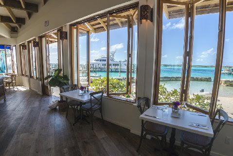
…and the original dining area is still part of the overall dining area and experience. Everything is just a little larger, so you and all your friends can enjoy breakfast, lunch, or dinner together !!

Staniel Cay is still the Bahamas quintessential “island atmosphere.”
And the Captains lounge area is still very much “Staniel Cay” charm.


Staniel Cay Yacht Club has been and remains a favorite Bahamas destination.
They are committed to making sure they can serve their loyal and new customers with the highest service standards.
We know, we’ve personally experienced their hospitality and it is indeed first class and five star !! The “laid back and enjoy” atmosphere is still very much their focus.
Staniel Cay knows how to make improvements while keeping the “main thing”…”the main thing” !!

Subject: Thank You: Airstrip Open!
Dear Staniel Cay Airport Supporters,
THANK YOU! Together, we did it! Our collective voice (and your many signatures!) encouraged action, and we are thrilled to report the re-opening of the Staniel Cay airport as of yesterday! The official notice can be seen at http://www.thebahamasweekly.com/publish/bis-news-updates/Staniel_Cay_Airport_Re-Opened_to_Air_Traffic45182.shtml
Once again, thank you so very much for your support and collective efforts. We look forward to welcoming you back to Staniel ‘“ as you land on our new and improved home airstrip!
Brooks Miller & Stephen Miller
on behalf of
Concerned Citizens of Staniel Cay & Vicinity
P.S. Our apologies for any duplication in emails as news of this exciting accomplishment spreads.

It is always nice to get good reviews and especially nice when it is on one of our SPONSORS! Jekyll Harbor Marina is one of my favorite stops – even Jimmy Buffett stops here! Jekyll Harbor Marina lies along the easterly banks of the AICW’s passage through Jekyll Creek, immediately south of the 65-foot fixed bridge.
Once safely through the shoals before the bridge, Jekyll Island Marina justifiably remains a favourite friendly stopover for boats of all shapes and sizes. Not only impeccable facilities but now they offer a courtesy golf cart enabling you to visit the brand new Beach Village stores and ogle at the huge mansions once owned by JP Morgan, Rockefeller and other “robber barons” of bygone years. Wonderful golf courses and even croquet amidst impeccable and super clean landscaping wherever you go. An onsite restaurant offers great local sea food dishes. Other amenities include a laundry, free WiFi, fish cleaning station, clean showers and fuel at competitive prices – I was able even to have Pisces pressure washed at very reasonable cost. Both staff and fellow boaters will do everything possible to make your stay pleasant and safe. During “snowbird” season, you might like to make a reservation either via VHF 16 or telephone (912) 635 3137. Undoubtedly a Five Star rating…….
Cap’n Parky
Click Here To View the Cruisers’ Net’s Georgia Marina Directory Listing For Jekyll Harbor Marina
Click Here To Open A Chart View Window, Zoomed To the Location of Jekyll Harbor Marina
Brunswick Landing Marina, a very popular facility with long term resident cruisers as well as transient cruisers sits well off the direct path of the Waterway, flanking the eastern banks of Academy Creek off Brunswick River, near the heart of downtown Brunswick, Georgia.
OK it’s around 5 miles off the ICW on the East River, but the extra mileage is well worth it. This is a first class marina at reasonably low cost. Immaculate floating slips, spotless restrooms and showers, free laundry, free to use BBQ and free beer. Diesel and Gas at competitive price. Nearby within walking distance are several restaurants including Thai, Chinese, Breakfast and goat curry. It’s a bike ride to an Autostore and a 5 mile taxi to the likes of Walmart, Publix and one of my favourites – Sonny BBQ. The marina accepts transients and liveaboards at competitive rates. You’re also likely to meet several of those intrepid Captains with tall masts who sail the world’s oceans. Contact the world’s friendliest Dockmaster on VHF 16 or Tel (912) 262 9264 AFTER you pass through 105 ft high cable bridge.. Five Star rating in my book.
Cap’n Parky
Click Here To View the Georgia Cruisers’ Net Marina Directory Listing For Brunswick Landing Marina
Click Here To Open A Chart View Window, Zoomed To the Location of Brunswick Landing Marina
Two Way Fish Camp is on the South Altamaha River, off the Waterway departing west between markers #218 and #218A. Old South charm and one of this editor’s favorite spots – well worth the trip!
Around Mile Marker 660 turn into the South Altamaha River to get a mile or so to the marina – watch the markers carefully on a “Red Right Return” basis. This super friendly marina is certainly much more than a fish camp – in fact the name reminds you that you can freshwater fish north of the marina, or saltwater fish south of the marina. Two way fishing. Floating slips are in good shape, an excellent ma and pa type restaurant on site and a haul out crane with repair yard able to fix most anything wrong. To be honest the restrooms and showers could do with a spot of modernization but the systems themselves worked well. Quite a few liveaboards here anxious to help a fellow boater get to the nearest grocery and other stores. Also a chance to make friends with Coastguard trainees who one day may come to your rescue – who knows? A Four Star rating in my book – five if they spruce up the restrooms.
Cap’n Parky
Click Here To View the Georgia Cruisers’ Net Marina Directory Listing For Two Way Fish Camp
Click Here To Open A Chart View Window, Zoomed To the Location of Two Way Fish Camp
We began hearing of extreme shallows at Hell Gate last year, see /?p=145174 and /?p=146335. Mike and Cathy wisely made this passage near high tide and had no problem. SSECN still recommends MID TO HIGH TIDE as a requirement for navigating through Hell Gate.
Just passed Hell Gate 1 hour before high tide- minimum observed depth 10 feet. Had approx 6 ft of tide
Mike & Cathy
S/V Second Flight
![]() Click Here To View the Cruisers’ Net’s “AICW Problem Stretches” Listing For Hell Gate
Click Here To View the Cruisers’ Net’s “AICW Problem Stretches” Listing For Hell Gate
![]() Click Here To Open A Chart View Window, Zoomed To This AICW Problem Stretch
Click Here To Open A Chart View Window, Zoomed To This AICW Problem Stretch
Harbortown Marina sits on the northern banks of Taylor Creek, which cuts into the Waterway’s western flank, south of unlighted daybeacon #184, just north of the Ft. Pierce Inlet.
Awesome restaurant and tiki bar at the marina! WiFi was so/so even being docked in front of the marina office! Advertisement stated that they have loaner bikes for transients’¦. they had one that was working. Different pricing for being on the wall vs. in a slip’¦. found this weird and backwards! More expensive to be exposed? Also had to listen to the bar noise and pay more? ASK to be in a slip!! Less per foot!! No grass for dogs’¦.. all area’s that were green had signs for NO DOG WALKING. Strange place, but the tiki bar was the bomb! 🙂
Still Clueless
Click Here To Open A Chart View Window, Zoomed To the Location of Harbortown Marina
They have grass for the dogs, but it is further into the parking area, closer to the pool.
Praise from Still Clueless parallels the many positive comments by other cruisers, as well as my personal experience there. Thunderbolt Marine flanks the Waterway’s southwestern shores just northwest of the small, charted square cove, south of AICW marker #35.
We cannot say enough about this marina! Easy in, easy out. FREE laundry! Awesome restaurant (Tuby’s) is just a short walk away. Immaculate shower/bathrooms. A true bargain! Will be back next summer, and every fall here out!
Still Clueless
Click Here To View the Georgia Cruisers’ Net Marina Directory Listing For Thunderbolt Marine
Click Here To Open A Chart View Window, Zoomed To the Location of Thunderbolt Marine
Completely agree… been there many times over the last few migrations… always consistently good !


Be the first to comment!