Pink Shell Beach Resort & Marina Recognized As One Of The Best in Florida
Pink Shell Beach Resort & Marina has been named to the 17 Best Resorts in Florida list by Traveluto, a rapidly growing travel blog. The resort was praised for its idyllic location, lagoon-style pool and waterfall, on-site marina, spa and tropical surroundings.
Pink Shell Beach Resort & Marina Recognized As One Of The 17 Best Resorts in Florida
FORT MYERS BEACH, Fla., July 9, 2015
Travelers heading to the Sunshine State this summer will find one more exciting reason to stay at Pink Shell Beach Resort & Marina.
One of the premier resorts on Fort Myers Beach recently made the list of 17 Best Resorts in Florida by Traveluto. A rapidly growing travel blog covering exciting destinations all over the world in addition to other travel-related topics, Traveluto searched the Sunshine State’s most popular resorts ‘“ from the Panhandle to the Florida Keys to the infamous home of Walt Disney World ‘“ to honor 17 must-visit hotel destinations in the state.
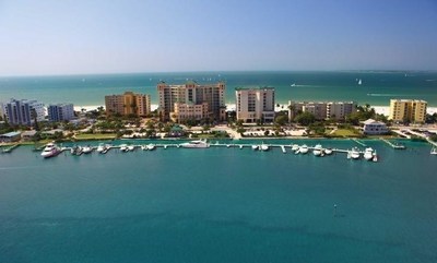
Situated on the beautiful tip of Estero Island, the full-service Fort Myers Beach hotel was praised for its lagoon-style pool and large waterfall, convenient on-site marina, spa and tropical restaurants, making it the ideal setting for spurring romance or making memories with the whole family.
In addition to the resort’s on-site amenities, the travel blog referenced its outstanding reviews on TripAdvisor, the world’s largest travel website. Pink Shell received numerous guest reviews raving about “amazing rooms with lanais,” “incredible views,” the “luxurious spa” and “friendly and accommodating staff.”
On top of making the list of 17 Best Resorts in Florida, the renowned Fort Myers Beach resort has been recognized with numerous awards including the 2014 Best of Weddings by The Knot, 2015 TripAdvisor Certificate of Excellence and Hall of Fame Award. Pink Shell also was voted the “Best Resort and Hotel of Fort Myers Beach” by Fort Myers Beach Observer and “Top 25 Best Places to Tie Up in North America” by the editors and readers of Power and Motoryacht magazine.
Starting off with a single cottage in 1953, Pink Shell has expanded across 12 lush acres and features 213 one- and two-bedroom condos, each offering sweeping ocean views from sunrise to sunset. Though it has grown, been renovated and rebranded since the original beachfront property that first sat on the sun-kissed sand, the resort celebrates the memories that were once made on Fort Myers Beach while providing all the amenities necessary for friends and families to make new ones.
About Pink Shell Beach Resort & Marina
Pink Shell Beach Resort & Marina at 275 Estero Blvd. in Fort Myers Beach, FL is on 12 lush acres of sugary white sand facing the Gulf of Mexico. The full-service destination resort features 213 one- and two-bedroom condos, all offering sweeping ocean views. Additional amenities include a 41-slip marina, full-service spa, 3 heated outdoor pools, 2 restaurants, 2 ballrooms, on-site sailing school and water sports. For information, visit www.PinkShell.com or call 1-888-222-7465. Like Pink Shell Beach Resort & Marina on Facebook, follow the resort on Twitter and add it to a circle on Google Plus.
About Boykin Management Company
Boykin Management Company, a leading hospitality management company with offices in Charlotte, NC and Fort Myers Beach, FL, is consistently recognized for excellence in delivering value-added lodging operations. Since 1958, BMC has been developing, managing and operating hotels, resorts, condominium hotels and conference centers. In addition to BMC’s long-standing relationships with the industry’s leading hotel brands including Marriott, Hilton, DoubleTree, Embassy Suites, Radisson, Crowne Plaza, Hampton Inn and Holiday Inn, BMC has operated numerous independent and resort hotels. BMC has managed more than 20,000 rooms in 23 states since its inception. For information, visit www.Boykin.com.
PRESS CONTACT
Ellis Etter
1-239-463-6181
eetter@pinkshell.com
SOURCE Pink Shell Beach Resort & Marina
Click Here To View the Western Florida Cruisers’ Net Marina Directory Listing For Pink Shell Beach Resort and Marina
Click Here To Open A Chart View Window, Zoomed To the Location of Pink Shell Beach Resort and Marina


Comments from Cruisers (1)
UPDATE: The yacht has been located, no details are currently available. BOLO (Be On the LookOut) has been canceled.