‘Time Aut’ Owner Seeks Insurance Payout for Abandoned Ship – Peter Swanson
|
When all else fails, try journalism.
 |
|
When all else fails, try journalism.
|


Charleston County Parks to host first Senior Sneaker Dance, February 22 in McClellanville
|

Key Lime Sailing Club, A CRUISERS NET SPONSOR, always has very special offers for their visitors! Key Lime Sailing Club is a unique slice of KEYS ENJOYMENT…give it a try and let us hear about your experience.
| ||||||||||||||||||||||||||||||||||||||
|

The City of Gulfport and Gulfport Municipal Marina, A CRUISERS NET SPONSOR, always have a full calendar of events for all ages. The marina and harbor, found on the northern shores of Boca Ciega Bay, are easily accessible from the Western Florida ICW, just north of Tampa Bay.
|
[Message clipped] View entire message
|
 |
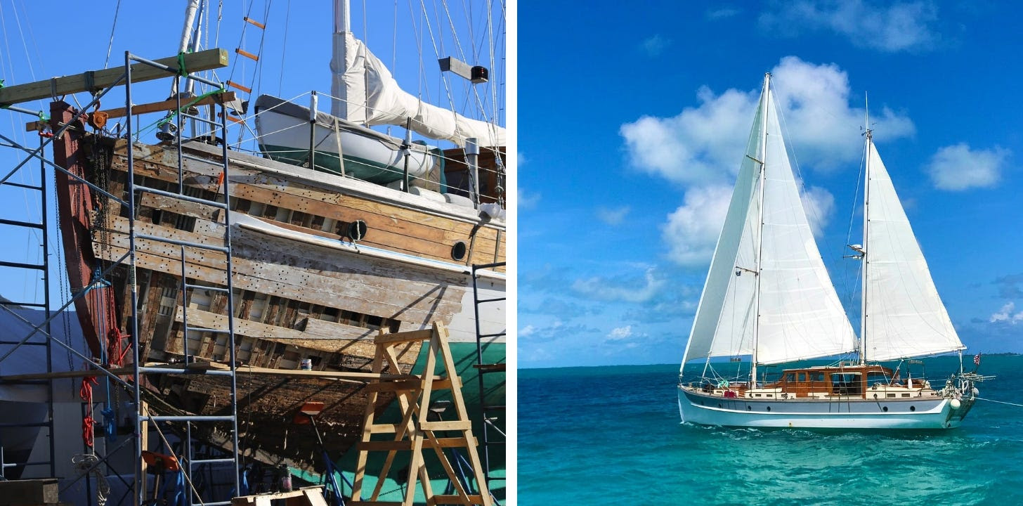
SPARRING WITH MOTHER NATURE ~~ latest addition. I’m very honored that you’re following along. Thank you from the bottom of my writer’s heart.
Ah, the life of a liveaboard Sailor…on a Classic Wooden Sailing Yacht… as of August 2024 we are undergoing extensive repair and refit for the next several months(!). In boating terms we are hauled out “on the hard” in Cambridge, Maryland.
I plan to mix Sailing Stories with the challenges and intricacies of restoring a 90-year-old boat. I’m always open to suggestions as to content….please feel free to weigh in as we manage and learn from this unexpected joust. Thank you! ~J
Share SPARRING WITH MOTHER NATURE
|
|
|

A longtime CRUISERS NET SPONSOR, historic Edenton always has an exciting calendar of events and places to visit! Edenton is at the mouth of the Chowan River on the northwest shore of Albemarle Sound.
101 W King St, Edenton, North Carolina 27932 |
Click Here To Open A Chart View Window Zoomed To the Location of Edenton Harbor City Docks

“Where the Wild Things Run” 5K and Kids Dash set for March 1 at Caw Caw Interpretive Center


|
|
|
|
| |||||||||||||||||||||||||||||||||||||||||||||||
|
 |
When all else fails, try journalism.
adrotate banner=’477′] Charleston Harbor Resort and Marina, A CRUISERS NET SPONSOR, sits on the Mount Pleasant side of Charleston Harbor, hard by Patriots Point between Horse Reach’s flashing buoys #34 and #36.
| |||||||||||||||||
| |||||||||||||||||
|
Click Here To Open A Chart View Window Zoomed To the Location of Charleston Harbor Marina
Cruisers Net is proud to be a member of the Atlantic Intracoastal Waterway Association whose lobbying work is crucial to keeping the Waterway navigable and safe. Your membership dollars directly support their vital work. Please join and encourage your boating neighbors to do likewise, regardless of their homeport.

|

BoatUS is the leading advocate for boating safety in the US and A CRUISERS NET SPONSOR.

BoatUS Foundation’s Ted Sensenbrenner Appointed to National Boating Safety Advisory Committee
![]()
Hatteras Island Oyster Roast Tickets on Sale!

Hatteras Island Oyster Roast
February 15, 2025
1 p.m. – 4 p.m.
The USCG doing what they do best!

01/05/2025 08:25 PM EST MIAMI – A Coast Guard Station Marathon boat crew rescued four people, Sunday, after their 27-foot vessel began taking on water approximately 11 miles north of Marathon, Florida. 
|
The City of Gulfport and Gulfport Municipal Marina, A CRUISERS NET SPONSOR, always have a full calendar of events for all ages. The marina and harbor, found on the northern shores of Boca Ciega Bay, are easily accessible from the Western Florida ICW, just north of Tampa Bay.
|
…
[Message clipped] View entire message
Click Here To Open A Chart View Window Zoomed To the Location of Gulfport Municipal Marina
Click Here To View the Western Florida Cruisers Net Anchorage Directory Listing For Gulfport Anchorage/Mooring Field
Click Here To Open A Chart View Window Zoomed To the Location of Gulfport Anchorage/Mooring Field
Having rebuilt the cockpit on our wooden Dickerson 35 yawl, where finding a 90 degree angle was cause for celebration, I can absolutely confirm Janice’s title!
SPARRING WITH MOTHER NATURE ~~ latest addition. I’m very honored that you’re following along. Thank you from the bottom of my writer’s heart.
Ah, the life of a liveaboard Sailor…on a Classic Wooden Sailing Yacht… as of August 2024 we are undergoing extensive repair and refit for the next several months(!). In boating terms we are hauled out “on the hard” in Cambridge, Maryland.
I plan to mix Sailing Stories with the challenges and intricacies of restoring a 90-year-old boat. I’m always open to suggestions as to content….please feel free to weigh in as we manage and learn from this unexpected joust. Thank you! ~J
The ongoing support of Cruiser's Net has been fantastic for my morale AND I have come to realize what an incredibly valuable resource this is. I share it at every opportunity and so should all of you, my fellow cruisers!
J
|
|
|
|
|
|
|
|
|
|
|
|
|
|
Our thanks to Ted Arisaka for forwarding this notice from Dec 23 on FB and on Bob423.

Click Here To Open A Chart View Window, Zoomed To the Location of Alligator River Marina


 Winter Blues? Not in the Keys!


Be the first to comment!