TowBoatUS Expands into Panama City, Strengthening Assistance for Recreational Boaters
Capt. Daimin Barth adds fourth TowBoatUS port to ownership portfolio along Florida’s Panhandle
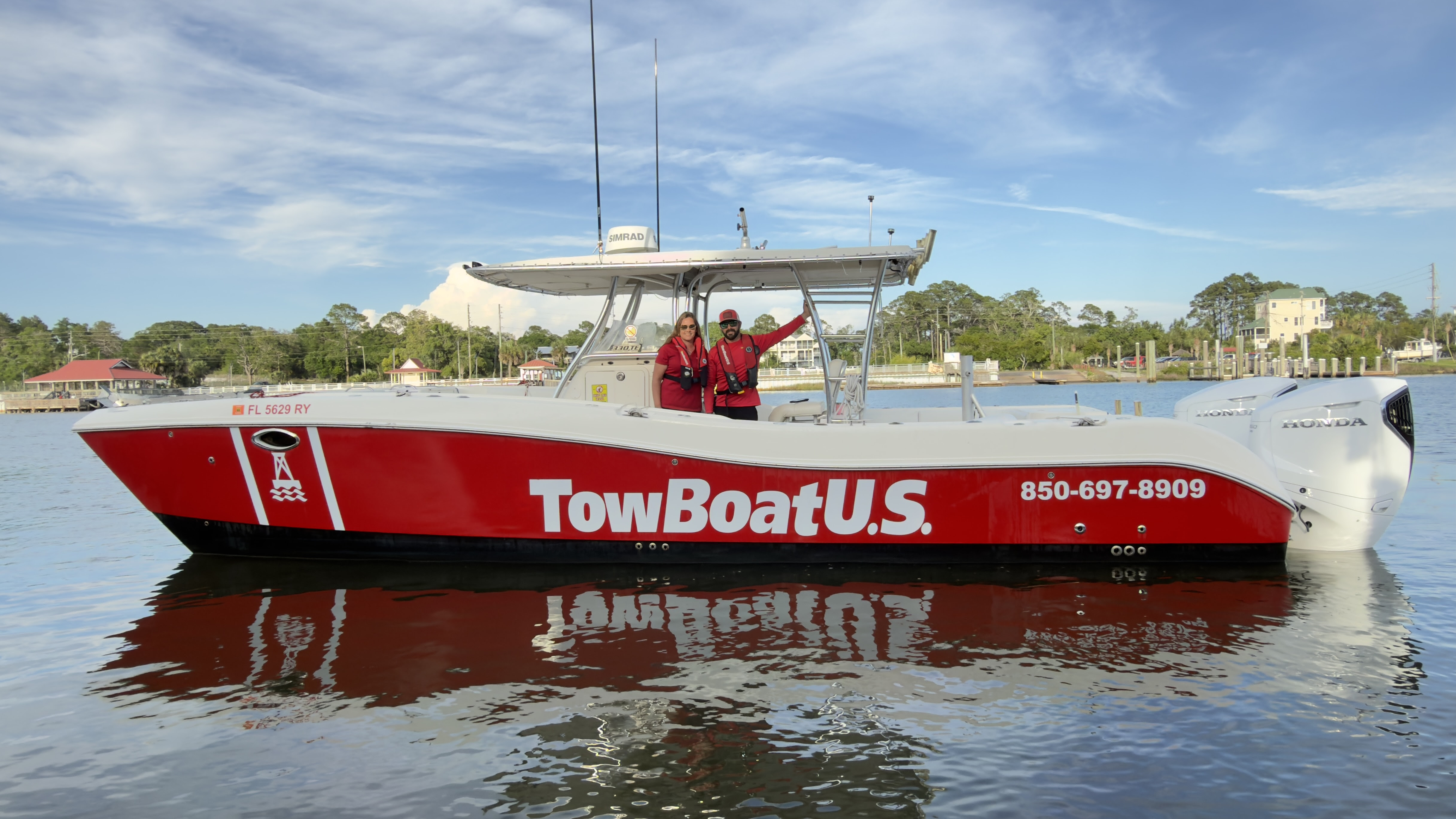
An image of Capt. Daimin Barth and his wife Amber Zigadlo
PANAMA CITY, Fla. – May 20, 2026 – TowBoatUS, North America’s largest network of on-water towing ports, announced today that U.S. Coast Guard-licensed captain Daimin Barth has opened his fourth TowBoatUS port, TowBoatUS Panama City, continuing the brand’s growth to service it’s more than 152,000 BoatUS members across the state of Florida.
Located in the heart of Panama City Beach, the port offers 24/7 on-water support to recreational boaters, including towing, fuel delivery, battery jumps, and soft ungroundings. Long-distance towing services beyond service areas listed on BoatU.S. member service locator may be available based upon conditions and availability. Separate from serving BoatUS Towing Members, the port also offers salvage, repairs, and prop disentanglement.
“As a captain-turned-port owner, I take pride in building on my experience responding to distressed boaters and know firsthand how fast response times can make all the difference,” said Barth. “With three existing locations across the Florida panhandle, we’ve strategically extended our reach geographically to better allow us to cover the region and respond to members quickly and when they need us most.”
The port will operate four TowBoatUS red response vessels crewed by U.S. Coast Guard-licensed captains, who are ready to respond to service calls. Vessels are strategically stationed at Sun Harbor Marina, Treasure Island Marina, a private dock in Parker, and on a trailer to service Deer Point Lake as well as other landlocked bodies of water. This distributed coverage allows the team to efficiently serve the entire Panama City Beach and Panama City area, reducing response times and ensuring help is always close by. The fleet ranges from 24 to 33 feet, enabling effective service in both shallow and deep-water conditions.
Much like an auto club for recreational boat owners, Boat Owners Association of The United States (BoatUS) offers on-water towing memberships for $215/year for saltwater. In addition to a BoatUS Towing Membership, members also receive more than 25 valuable BoatUS benefits including a subscription to award-winning BoatUS Magazine, free DSC-VHF radio registration and more.
To request on-water assistance, boaters can call the BoatUS toll-free 24/7 Dispatch Center at 800-391-4869, download the free BoatUS App, which connects boaters to the closest local towing captain, call TowBoatUS Panama City directly at (850) 697-8909, or hail on VHF radio Ch. 16.
###
About TowBoatUS
Boat Owners Association of The United States (BoatUS) is the nation’s leading advocacy, services and safety group for recreational boaters. We provide more than 740,000 members with a wide array of helpful services, including 24-hour on-water towing that gets boaters safely home when their boat won’t, as well as jump-starts, fuel delivery, and soft ungroundings. The TowBoatUS towing fleet is North America’s largest network of towing ports with more than 330 locations and over 630 red towboats, responding to more than 110,000 requests for assistance each year. To learn more about becoming a TowBoatUS member, visit BoatUS.com/Towing, and to find a TowBoatUS location closest to you, visit BoatUS.com/ServiceLocator.
You are receiving this email because you were included on Geico (Government Employees Insurance Company)’s media release. To unsubscribe and stop receiving emails from this organization click here.
Cruisers Net publishes Loose Cannon articles with Captain Swanson’s permission in hopes that mariners with saltwater in their veins will subscribe. $7 per month or $56 for the year; you may cancel at any time.
Aaron Hirschhorn died on March 28, 2021, while piloting his hoverboard in Biscayne Bay, Florida. He had collided with a center-console. (Instagram)
Five years ago, the owner of a Chris Craft Launch 38 collided with a guy on an electric foil hoverboard, and he was pronounced dead at the scene. Aaron Hirschhorn, a celebrity entrepreneur, was survived by his wife Karen Nissim and their three young children
Insurance companies for the Chris Craft owners denied the Hirschorn family’s claim for compensation, spawning a legal battle so epic that it would rival the upcoming summer movie Odyssey with a legion of suit-wearing attorneys instead of helmeted Greek heroes. At stake is a $66 million arbitration award.
“The insurers denied coverage for the subject accident, declined to pay any amount on the claim, and refused to defend their insureds in litigation,” Lawyers for Karen Nissim wrote. In other words, the lead insurance company tried to walk away from their own clients on the basis of a couple technicalities—a move barred under Florida law.
Florida’s so-called “anti-technical” statute is “designed to prevent the insurer from avoiding coverage on a technical omission playing no part in the loss.”
The recalcitrant insurance company is defendant Yachtinsure Services, a managing general agent and claims-management firm representing “actual insurers” Clear Blue Specialty Insurance and Aspen American Insurance Company, who each provided coverage to one of the two partners that owned Caprice.
(At this point it should be noted that one of the owners himself died a few months before the accident.)
According to the lawsuit, Yachtinsure refused to settle the claim against itself and the two companies or defend them in court.
Yachtinsure denied the claim under the dead owners’s policy because the live owner, who was operating the vessel, was supposedly an “unapproved operator.” This, even though the live owner’s separate policy—also administered by Yachtinsure— specifically listed live owner Randy Harmat as an operator.
So how did Yachtinsure deny coverage under the Harmat policy listing him as an operator? Kissim’s lawyers take up the story:
Coverage for the Harmat Policy claim was denied on the purported grounds that there was a “misrepresentation and failure to disclose material information related to a prior loss involving the Vessel.” The purported “misrepresentation” that justified its denial of the claim was the “fail[ure] to answer the question” on the insurance application whether “the vessel suffered any damage or undergone repairs in the last five years.”
Which, of course, raised the question: If this were an issue, why was the policy issued to Harmat in the first place? Especially after the answer blocks appear to have been filled in, then erased.
In May 2022, an arbitrator apportioned blame in the accident, deciding that Hirschhorn was 25 percent at fault, while the estate of the guy who died before the accident happened was 75 percent at fault. Based on Hirschhorn’s young age—he was 42 when he died—and the likelihood of future earnings, the arbitrator ruled that his family was entitled to $66 million even after factoring Hirschhorn’s own culpability.
Then in January 2024, Harmat the living owner agreed to the same settlement under the ancient legal doctrine of any party not at the table is on the menu.
Actually, it is called a Coblentz agreement, which refers to a negotiated consent judgment “entered into between an insured and a claimant in order to resolve a lawsuit in which the insurer has denied coverage and declined to defend.”
The agreement guaranteed that Hirschhorn’s survivors would not go after Harmat or his dead partner’s estate for the settlement—only the insurers.
Here’s where it gets interesting. Both insurance policies were limited to $500,000 payouts, but lawyers for the widow argued that, under Florida law. Yachtinsure’s “wrongful refusal to defend the claim” mean that those limits went out the window and the entire $66 million was at play.
Through its lawyers, Aspen Insurance argued that the arbitration award agreed to by the plaintiff and the boat owners “was not reasonable and is the result of collusion, fraud or lack of ‘good faith’.”
Aspen, which represented the dead owner, also argued that his policy died with him and that Aspen, therefore, didn’t owe Hirschhorn’s survivors a nickle.
That’s just a quick and undoubtedly incomplete summary of just one of five federal lawsuits arising from the untimely death of Aaron Hirschhorn. Some have been settled, but the central case had 284 document entries as of last week—with no sign of letting up.
Chief takeaways: Read your policy. Ask questions. Realize that Florida’s anti-technicality law may not be the case in your state.
A sistership to the Chris Craft in question.
LOOSE CANNON covers hard news, technical issues and nautical history. Every so often he tries to be funny. Subscribe for free to support the work. If you’ve been reading for a while—and you like it—consider upgrading to paid.
There is always plenty to do around Charlotte Harbor! While berthed at Fishermen’s Village Marina, A CRUISERS NET SPONSOR, you are certain to enjoy visiting Western Florida’s beautiful Charlotte Harbor/Peace River.
Fred Pickhardt’s Substack is free today. But if you enjoyed this post, you can tell Fred Pickhardt’s Substack that their writing is valuable by pledging a future subscription. You won’t be charged unless they enable payments.
The ENSO Diagnostic Discussion issued by NOAA’s Climate Prediction Center on May 14, 2026, indicates that ENSO is transitioning toward an El Niño event.
While the system is currently in an ENSO-neutral state (neither El Niño nor La Niña), there are strong signals that this will change very soon.
Key Highlights:
Emergence of El Niño: There is an 82% chance that El Niño will emerge between May and July 2026.
Long-term Outlook: The event is expected to persist through the Northern Hemisphere winter of 2026–27, with a 96% probability during the December–February period.
Oceanic Conditions: Sea surface temperatures (SSTs) in the east-central Pacific are currently near average, but subsurface temperatures have been rising for six consecutive months. This “warm pool” below the surface is a precursor to the development of El Niño at the surface.
Atmospheric Coupling: Low-level westerly wind anomalies have been observed, which helps push warm water toward South America, further fueling the El Niño development.
Strength and Impact:
Uncertainty in Intensity: While experts are confident El Niño will happen, its peak strength remains uncertain. This summer, a weak El Nino will likely become moderate during the late summer and early fall. Thereafter, there is significant uncertainty as the probability distribution is relatively evenly spread between moderate to very strong with no specific category having more than a 37% chance of occurring.
Risk Assessment
Based on the May 2026 ENSO Diagnostic Discussion, the following table provides the percentage probability for each strength level of El Niño (and Neutral conditions) for the upcoming seasons.
The strength is determined by the Niño-3.4 Index (sea surface temperature departures in the east-central Pacific).
El Niño Strength Probabilities (%)
Analysis of the Data:
Peak Intensity: The forecast suggests a steady intensification throughout the year. While the event starts as “Weak,” the probability of a “Very Strong” El Niño (≥ 2.0°C) increases significantly toward the end of the year, peaking at 37% during the November–January period.
Winter Outlook: By the Northern Hemisphere winter (DJF), there is a combined 60% chance of the event being either “Strong” or “Very Strong.”
As we move into early summer, the model uncertainties will diminish and we will be able to better predict the peak intensity.
Cruisers Net publishes Loose Cannon articles with Captain Swanson’s permission in hopes that mariners with saltwater in their veins will subscribe. $7 per month or $56 for the year; you may cancel at any time.
Rudolpho Alexander of St. Vincent & the Grenadines was gratified to learn that his boat, stolen from the anchorage at Frigate Island on Saturday, has been recovered by authorities in Venezuela.
Alexander, owner of the Famous Liquor & Smoke Shop, said the Venezuela Coast Guard had notified their St. Vincent counterparts that they have possession of the CS 40 sloop named Great Habit. And that’s about all he knows, not even her precise location in that troubled South American nation.
Today he was wondering what kind of bureaucratic hurdles and expense will face trying to recover his boat from a place that has long been a no-go for foreign sailors. Alexander does not speak Spanish.
“Well, I’m just waiting for an update from the Coast Guard. I hope it’s not going to cost me too much now,” Alexander told Loose Cannon. “I may just have to leave it, or try to sell it or something.”
Alexander said he found Great Habit on a dock in Carriacou where she lay with hurricane damage in 2024. He bought her from a man at the boatyard who had acquired the boat either from the previous Canadian owners or their insurance company. He kept the Great Habit name.
Venezuela has several Coast Guard bases a one or two day reach from St. Vincent, including at La Iguana Island, Barcelona, La Guaira (near Caracas), Carúpano, and Margarita Island.
LOOSE CANNON covers hard news, technical issues and nautical history. Every so often he tries to be funny. Subscribe for free to support the work. If you’ve been reading for a while—and you like it—consider upgrading to paid.
TowBoatUS and BoatUS Foundation Partner with Lynnhaven River NOW to Remove 10 Abandoned Boats from Virginia Waters
Effort is part of larger initiative to remove up to 100 vessels and address growing abandoned and derelict vessel (ADV) issue
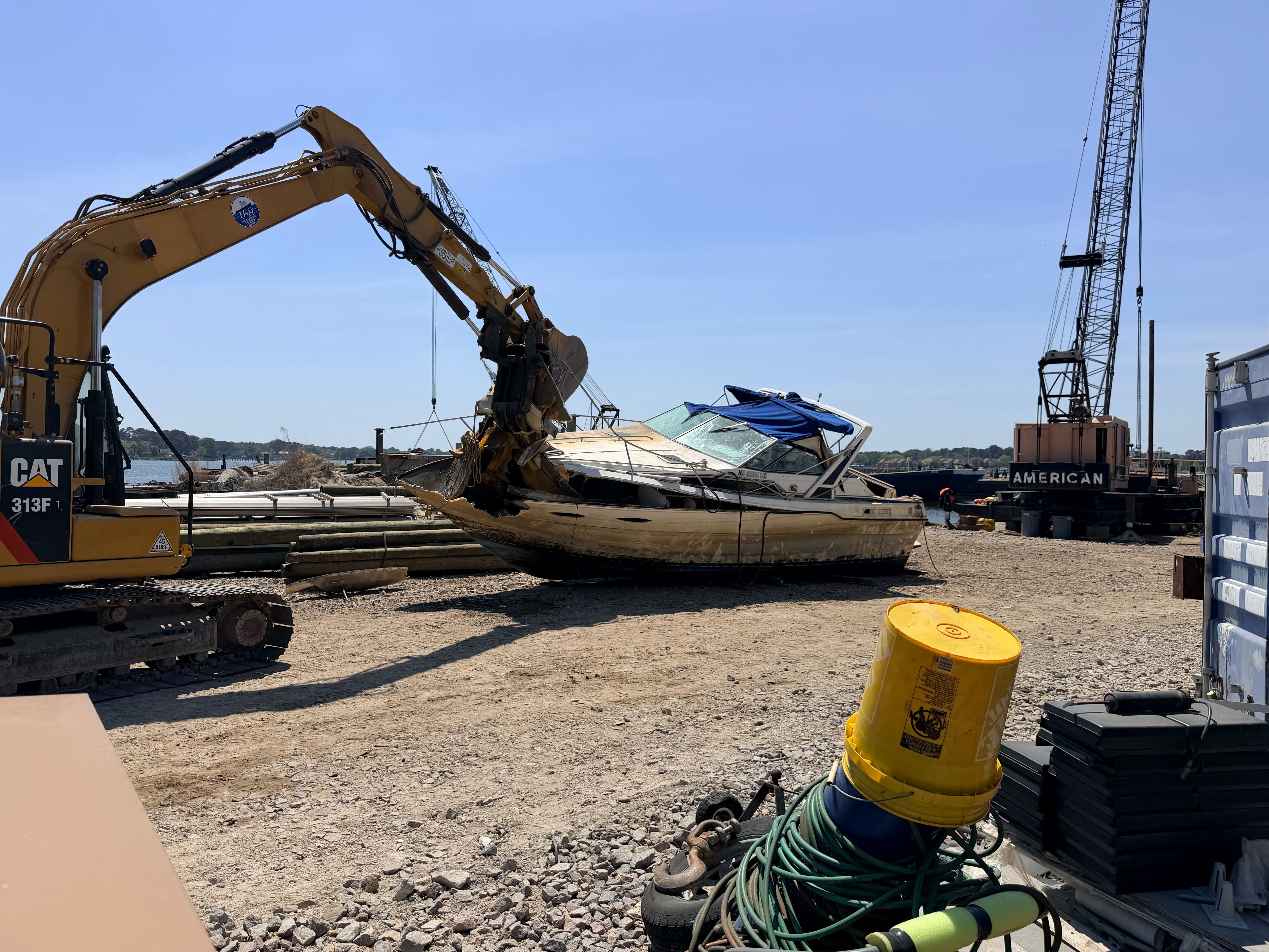
An image of an ADV removed from the Elizabeth River and crushed for disposal.
Photo Credit: BoatUS Foundation
SPRINGFIELD, Va, May 19, 2026 –The BoatUS Foundation, a national leader promoting safe, clean and responsible boating helped Lynnhaven River and TowBoatUS at ports Gwynns Island and Portsmouth, remove 10 abandoned derelict vessels (ADVs) from waterways across Gloucester and Portsmouth, Virginia. This initiative is aimed at addressing navigational hazards and environmental impacts of ADVs on coastal Virginia waterways. The removals took place April 14–16 and are part of a broader effort to remove up to 100 ADVs in the area.
Lynnhaven River NOW’s project brought together nonprofit, government and private partners to address the growing environmental and navigational risks posed by abandoned boats. This project is supported by a 2023 award from the National Oceanic and Atmospheric Administration (NOAA) Marine Debris Program.
“Abandoned boats don’t just disappear. They become a burden on communities, the environment and local economies,” said Alanna Keating, Director of Outreach at BoatUS Foundation. “By connecting trusted partners, we are addressing the issue of ADVs and making real progress toward cleaner, safer Virginia waterways.”
Removing abandoned vessels provides immediate benefits to local waterways and communities. Left unattended, these vessels can leak fuel, create navigation hazards, and harm marine ecosystems and shorelines. Their removal enhances boater safety, safeguards natural habitats, and helps prevent lasting environmental damage.
TowBoatUS operators Chris Parker of Gwynns Island and Donald Duck of Portsmouth were contracted to do the removals, volunteering significant time and resources while working through a wide range of vessel conditions.
“Every removal is different, and often more complex than people realize,” Parker said. “Some vessels can be refloated and towed, while others need to be taken apart piece by piece. It takes time and coordination, but the impact on the community and the bay is significant once removed.”
“These boats pose real risks to navigation and safety,” Duck said. “We see how they can break free, damage property, or require emergency response. Prevention through proper insurance and responsible disposal can make a big difference.”
Local leaders in attendance during the local cleanups included Gloucester County Administrator Greg Gentry, Virginia Department of Environmental Quality Coastal Zone Manager Jeff Flood, and Portsmouth Mayor Shannon Glover.
Anyone who encounters an abandoned or derelict vessel on a waterway is encouraged to report it at https://boatus.org/adv-database.
###
ABOUT THE BOATUS FOUNDATION:
BoatUS Foundation is supporting projects that were selected through their nationally competitive grant program for the removal of abandoned and derelict vessels throughout coastal and marine areas of the United States, including the Great Lakes, U.S. territories, and Freely Associated States. In an effort to help educate and prevent future ADVs, the Foundation created a national ADV database to track the scope of the challenge and measure success, document ADV prevention and removal activities to share with the public and support a national dialogue and education efforts on boating-related debris disposal. This project is supported by a 2023 award from the NOAA Marine Debris Program.
ABOUT TOWBOATUS:
TowBoatUS is the nation’s largest on-water towing and assistance service, with more than 300 locations across the United States. Captains are U.S. Coast Guard-licensed professionals who provide 24/7 on-water assistance including towing, soft ungroundings, battery jumps and fuel delivery. TowBoatUS also plays a critical role in supporting marine debris removal and response efforts in partnership with local and national organizations.
ABOUT LYNNHAVEN RIVER NOW:
Lynnhaven River works with residents, businesses, faith communities, schools, and community leaders to restore and protect Virginia Beach waterways and natural resources. LRNow believes that every community should have pure water, clean air, and access to open spaces for recreation. LRNow believes that every community should have pure water, clean air, and access to open spaces for recreation.
Hey Secret Sparring Society—we’re getting there on this project. Promise. Raised her up for final keel work. She’s looking like a sailing yacht! Whoop whoop.
If you just found our very engaging little community, please read SPARS & SPARRING, .….it introduces my wonders and my wanders. ~J
Nope—it’s not Sunday. I’m interrupting my accidental boatbuilding project (which is a whole other art form, really) with a worthy musician, a second intro of sorts. You’re receiving this week’s publication one day early for an extraordinary reason– Saturday night this writer will be up late because the keyboard aficionado protagonist of my latest work is performing as he does many times each month. This time, there is much to celebrate—a book debut and a birthday, neither of which should ever go unnoticed. If you’re local to the Chesapeake Bay (sorry you folks down under….!), join an incredibly talented group of musicians AND the debut of “WHO IS JIMMY WARREN?” at a mod little venue in Annapolis, Maryland, 49 West. Signed copies. Admiration. Secrets revealed. No better way to showcase art than energetic vibe and table service.
Jimmy Jacobs and Jimmy Warren have the same talented hands.
Thus far royalties won’t cover the cost of my next tank of gas, but the response from people, the surprise and intrigue from those who know Jimmy well and from those who will never meet him, is reward enough. That’s why writers do what we do. And when people get the jist of this particular story, they’ll buy the book, regret that they didn’t, or neither. (I assure you do NOT have to be a Grateful Dead fan.)
When Jimmy’s dad turned 80, he told his son that ‘if he had regrets about life, it was more for the things he didn’t do than the things he did.’ Throughout the extensive, very personal process of sharing stories and editing the depiction, that quote didn’t come to light and was not included in the original publication. During the revisions, I made sure it got in there.
Mother Nature gifted some of us with musical abilities. Others, such as myself, staying in tune is a hard no. I tell another’s story from their point of view; I’ve practiced, and I have a talent that, honestly, I cannot fully explain; I’m not boasting because it’s rather confounding sometimes and can give me pause. My short intrusion, the time I take as their storyteller, is a tiny percentage of that person’s life. They LIVED THEIR STORY. They CREATED THEIR STORY, whether intentionally or with a random chain of events triggered by ‘sure.’ Most tales never get told.
Me? I’M PASSIONATE ABOUT IT. Fascinated, intrigued, energized, moved by the stories people have underneath calm demeanors and outwardly ordinary lives, people who, day to day, walk by you on the street and stand behind you in the grocery store; they hear the same bad news and yet prevail with their strengths and talents that no one even realizes because they still have to eat and drive and pay their rent and no one has time to consider the past when it’s hard to contemplate a shaky future and then their talents diminish with each passing year of misuse, (or do they), and everyone comes to believe that the story is not worth telling but it probably is, whether to a meeting or a friend or an author or whoever you think might be your Higher Power, it’s worthy, I tell you. Maybe more than worthy.
Stories don’t have to be printed, they just have to be shared, reflected upon, considered, learned from and noted, remembered, respected, archived and MOST IMPORTANTLY, listened to. Do we listen? Most folks are simply looking for someone to make them feel important. While I understand, deeply, that time is a valuable commodity, it is the only cost of listening to a fellow human being who simply needs a kind audience and to feel like they matter. STEADFAST is visible and accessible enough that we have folks, boat-loving folks, strangers, wanderers, and friends drop by and simply start reminiscing, telling tales from Navy service to piano repair, fortunes lost to dreams come true. They’re looking for a commonality and an audience. Both can be hard to find.
Nine weeks ago in a moment of madness I signed up for an online class called “The Science of Happiness.” My first session is still in an open tab, stuck on the ‘pause’ icon thirty minutes into my trip down joyful lane. I should have known that there was not enough room for that this month. I wanted there to be. We all chase happiness, don’t we? What IS the science of happiness? Perhaps my warm, fuzzy, Carpenter-bee loving self was secretly a little appalled that it was a science instead of an art form. The happiness professorial team are so determined to hear from me that they send emails begging for a continuation of the education I never got and didn’t need. I’m kick-ass happy this weekend to be signing books with storied pianist Jimmy Jacobs aka Jimmy Warren aka Jimmy Johnson aka…we all get to showcase our art.
Rather late last night two folks knocked on the port hull of Miss STEADFAST just as I started editing this piece. I didn’t have time for a visit, but as I peered down, a lifetime of politeness prevailed. They requested a tour, told their story—two pilots with a newly acquired passion and 46’ Vagabond sailboat under repair (by other people). Their enthusiasm was genuine; their timeframe will be longer than they expect. We talked SPARRING WITH MOTHER NATURE, they climbed down the ladder with contact info tucked away—STEADFAST’s story, if they choose to access it, and my own. Whether they ever contact me or not, I’m glad I took the time.
Next time someone needs to be listened to, it just might be worthwhile, or it just might be you. ~J
Happy Hippies everywhere. Jimmy tickles those ivories with no sheet music in sight, ever, and very talented Birthday Man Dean Rosenthal is on the left.
***** WHO IS JIMMY WARREN? is an “All Access” back stage pass to the music scene of the 70s and 80s. It’s also a page-turning thriller with danger and heart-pounding adventure! Lon Holmberg
***** I loved the way this was told….What a life Jimmy lived. So glad he decided to tell his story. Definitely a different time…buy this book! Debby
It’s not simple or easy to put great stories into words. If you think I string them together in a worthwhile fashion, you can support my assorted writing endeavors, as some of you already do with a thumbs up, a comment, a purchase, a re-stack or an upgrade—whatever works for you works for me.
Cruisers Net publishes Loose Cannon articles with Captain Swanson’s permission in hopes that mariners with saltwater in their veins will subscribe. $7 per month or $56 for the year; you may cancel at any time.
The author is editor and publisher of the recently launched outlet Center Console Angler. This veteran fishing journalist has continuously owned at least one center-console boat since 1980, sometimes two and occasionally three at a time. He has long been a disciple of the center-console lifestyle.
I distinctly remember the first center-console boat I ever saw. It was in south Miami in the mid-1960s, and I was in elementary school. While driving along Coral Reef Drive one day, my father spotted the boat sitting on a trailer beside a gas station on U.S. l. He immediately did a highly illegal U-turn and pulled into the station.
The shiny new Aquasport, probably a 17-footer, sat on a trailer and dad repeatedly circled the boat, shaking his head, saying, “This makes so much sense.”
At that point, we owned a 22-foot aluminum DuraCraft with an enclosed bow, a windshield, and a helm to starboard. It had a pretty big cockpit, but we were light-tackle fishermen, and like all boats with enclosed bows, it left something to be desired when you had a big fish hooked up. I remember scrambling over the windshield to the bow many times while fighting a dolphin or a kingfish. We didn’t think about the inconvenience, that’s just the way it was.
But suddenly, an incredibly practical alternative had appeared. Now you didn’t have to crawl over an obstacle course while fighting a fish because you had clear passage 360 degrees around the boat. It seems like a simple thing now, and we all take it for granted, but back then it was a very big deal. It took a few years for us to get our first center console, a 22 Mako that Dad bought in 1971, but our family has owned at least one center-console boat ever since.
The center console existed long before that day in Miami, of course. Great debate centers on precisely when and where someone built the first one and who built it. In New England, dory boats served as marine workhorses for decades before the true center console appeared, and some of them had rudimentary center helms. And Chris Craft built center helm runabouts as early as the 1930s. But a centered helm does not a center console make. These boats lacked the defining feature of the true center console, namely the ability to move freely from bow to stern.
In researching this story, the name Scopinich came up repeatedly. This famous boat-building family from Long Island, New York, built a plywood 22-foot runabout in the early 1950s called the “Scop Cruiser,” powered by six-cylinder Gray 109 inboards. Early versions of the boat did not feature a center console, but an accident in the boatyard changed that.
In 1952, a huge electric screwdriver fell off a second story platform in the boat building shed and went right through the deck of a Cruiser being built below. Luckily, no one was injured, but the boat now had a huge hole right in the middle.
Being resourceful craftsmen, Fred Scopinich Sr. and Jr. went to work repairing the boat, and instead of installing the usual forward, off-center helm, they built a box out of plywood and positioned it in the center of the boat, attaching the helm to the box. They immediately recognized the innate practicality of the design and began using the boat in the waters around Long Island.
The boat instantly drew attention from admiring boaters in the area, and soon, representatives from the Douglaston Yacht Club of Great Neck darkened the doorway of the Scopinich yard and commissioned them to build six center consoles, which the club would use as tenders. The Scop Cruiser may well be the first true center console built on a semi-production basis.
The “Scop Cruiser” was the result of an accident in 1952, but became an instant success. 22-year-old Mario Scopinich is pictured at the helm. Photo courtesy of Scopinich Boat Works.
Another milestone occurred when Dick Fisher formed Boston Whaler in 1958. The first Whalers were the famous 13-footers that Fischer sawed in half in the best boat ad ever, and they weren’t center consoles. In 1961, Whaler introduced the 16-foot Nauset, with the beautiful mahogany center console that became a legendary Whaler trademark on many subsequent models. The Nauset is generally considered to be the very first production center-console boat.
Chris Craft introduced a center console lapstrake boat called the “Dory” in 1962, and Aquasport began producing fiberglass boats in ’65 or ’66. Carl Moesly built the first center console Sea Craft in 1966, putting a center console on a bow rider hull. Moesly invented the famous Sea Craft variable deadrise deep-vee hull in ’62 or ’63 and received a patent on it a few years later.
In 1967, Bob Schwebke founded Mako Marine after he couldn’t find a boat that he liked, building a 19-footer to use in the shallow waters around Flamingo in extreme south Florida. Bob Hewes began producing center console flats skiffs in the late ’60s, and although Willy Roberts had been building custom center console skiffs out of wood for years in the Florida Keys, the Hewes Bonefisher was the first fiberglass, production flats skiff. Companies that introduced center consoles in the late 1960s or very early ’70s include Pro-Line, Robalo, Formula, Bertram and others.
The center-console design became so popular that Sports Illustrated magazine ran a feature about the phenomenon in 1969.
Also in ’69, Schwebke hired a young marketing director named Bill Munro, and in 1970, Munro put on the very first Mako Owner’s Toumament. He led a small fleet of 17, 19, and 22-footers to Walkers Cay in the Bahamas, and the modern owner’s tournament was born. These owner’s events became hugely popular, helping catapult Mako to the top of the center-console market in the ’70s and ’80s, but they did something else of arguably greater importance—they helped transform the center-console boat from a practical and utilitarian fishing platform, into a lifestyle.
Today’s center consoles are a far cry from those early boats. Modern coring materials and better knowledge of fiberglass encapsulation have eliminated rot for the most part and have also made the boats much lighter. Computers now design hulls and place fuel tanks for optimal weights and balances, and the invention of the T-top allowed owners to hang Isinglass curtains and electronics boxes overhead. Consoles became more sophisticated, with large surfaces for mounting electronics, toe recesses, footrests, tackle storage, and head compartments.
Remember when all of your electronics mounted on brackets on top of the console, and you unscrewed them and brought them in the house when not in use? Now most units get permanently flush-mounted, often in lockable spaces.
“Those early boats had zero storage beneath the deck,” said Owen Maxwell of Regulator Marine, “so your coolers, tackle boxes, buckets, everything sat on deck and slid all over the place while you were running.” Maxwell says cleverly designed storage spaces have been a huge innovation. “But the biggest change was probably the invention of the head compartment,” he added, “so now the ladies would get on the boat with us.”
“I think the most notable development is the closed transom,” said Joe Neber, President of Contender Boats. “First the bracket and then the integral bracket, raised livewell designs we have today. The closed transom has allowed us to build deeper vees, add larger motors, and build bigger boats that are ultimately more seaworthy, and therefore go farther offshore in search of fish.”
All center-console boats still share the one design feature that makes them unique and so eminently practical—a centered helm with clear walking spaces on either side. It’s a design that redefined the boating industry, and as refinements keep coming our way, CenterConsoleAngler.com will be here to tell you about them.
Center consoles have evolved and grown exponentially since the early days! Photo courtesy of Valhalla Boatworks.
LOOSE CANNON covers hard news, technical issues and nautical history. Every so often he tries to be funny. Subscribe for free to support the work. If you’ve been reading for a while—and you like it—consider upgrading to paid.
TowBoatUS Steinhatchee Under New Ownership, Continuing Trusted On-Water Assistance Along Florida’s Gulf Coast
New owner-operator Carson Mullen steps in to ensure dependable service for local boaters from Cedar Key to the Econfina River
An image of Carson Mullen, Owner-Operator of TowBoatUS Steinhatchee
STEINHATCHEE, FL – May 14, 2026 – TowBoatUS, North America’s largest network of towing ports, announced today that U.S. Coast Guard-licensed captain Carson Mullen has taken the helm of TowBoatUS Steinhatchee.
With more than 152,000 BoatUS members across Florida, access to dependable on-water assistance remains an important resource for the state’s boating community. TowBoatUS Steinhatchee serves Florida’s Big Bend coastline from Cedar Key to the Econfina River, a service area extending 25 miles offshore and known for its remote access points.
Mullen brings several years of hands-on experience with TowBoatUS, having served as a captain in multiple locations before purchasing the Steinhatchee port. With peak boating season underway along Florida’s Gulf Coast, this transition ensures continuity of service for the region’s tight-knit coastal boating community while positioning the port for future growth.
A lifelong boater originally from Lake Wylie, South Carolina, Mullen grew up on the water in a family passionate about boating and water sports. After being introduced to the process of becoming a licensed captain, he quickly acted on the opportunity to build a career, eventually serving as a captain at TowBoatUS Lake Wylie before relocating to Southwest Florida.
“Boating has always been a part of my life, and being able to turn that into a career and a business is incredibly rewarding,” said Mullen, owner and operator of TowBoatUS Steinhatchee. “This is a small, close-knit boating community, and my goal is to build on the strong foundation already here while continuing to provide dependable, professional service. When Gulf Coast boaters need help, I want them to know they can count on me to get them home safely.”
TowBoatUS Steinhatchee is based at Sunset Place Marina, located at the mouth of the Steinhatchee River, where it operates a 25-foot Boston Whaler Frontier response vessel. Operated solely by Mullen, the service provides towing, fuel delivery, battery jump-starts, and assistance for boats that run aground, serving as a critical first call for recreational boaters when unexpected issues arise on the water.
Much like an auto club for recreational boat owners, Boat Owners Association of The United States (BoatUS) offers on-water towing memberships for $215/year for saltwater. In addition to a BoatUS Towing Membership, members also receive more than 25 valuable BoatUS benefits including a subscription to award-winning BoatUS Magazine, free DSC-VHF radio registration and more.
To request on-water assistance, boaters can call the BoatUS toll-free 24/7 Dispatch Center at 800-391-4869, download the free BoatUS App, which connects boaters to the closest local towing captain, call TowBoatUS Steinhatchee directly at (352) 550-3009, or hail on VHF radio Ch. 16.
About TowBoatUS
Boat Owners Association of The United States (BoatUS) is the nation’s leading advocacy, services and safety group for recreational boaters. We provide more than 740,000 members with a wide array of helpful services, including 24-hour on-water towing that gets boaters safely home when their boat won’t, as well as jump-starts, fuel delivery, and soft ungroundings. The TowBoatUS towing fleet is North America’s largest network of towing ports with more than 330 locations and over 630 red towboats, responding to more than 110,000 requests for assistance each year. To learn more about becoming a BoatUS member, visit BoatUS.com/Towing and to find a TowBoatUS location closest to you, visit BoatUS.com/ServiceLocator.
National Safe Boating Week Is May 16-22: BoatUS Foundation Reminds Boaters to Prepare for Season
BoatUS Foundation highlights critical safety tips before hitting the water
SPRINGFIELD, Va. – May 12, 2026 – This year, National Safe Boating Week begins on May 16 and runs through May 22. This week serves as an important reminder to encourage boaters to be responsible and prioritize safety ahead of the start of boating season. This observance week is the official kickoff of the Before You Boat campaign from the BoatUS Foundation.
Before You Boat … Check your fit: Take a few minutes to ensure you have enough right-sized life jackets for everyone aboard and that they are readily available in case of an emergency. While on board, wear your life jacket and ensure you are meeting your state requirement for life jacket wear by visiting https://www.boatus.org/life-jackets/state-requirements.
Before You Boat … Inspect your beacon: Confirm your emergency beacon is working and accessible, so help can find you quickly in case something unexpected happens. Pro Tip: Rent a beacon for free through the BoatUS Foundation EPIRB rental program.
Before You Boat …File a float plan: Let someone know where you’re going and when you’ll be back. This can be as simple as texting your trip details to a trusted friend or family member who is ready to act if you’re overdue.
Before You Boat … Attach your ECOS: If your helm is equipped with an engine cutoff switch and your boat is 26’ or under, attach it to your person. This will help stop your engine immediately if you’re thrown overboard.
Before You Boat … Check the weather: Use free apps like Tide Alert (NOAA) to check weather conditions and tides before heading out.
Before You Boat … Make safety a priority: Treat safety as part of the trip, not as an afterthought. BoatUS Foundation offers the only free online boating safety course, currently approved in 37states, register here and get started.
“Safe boating doesn’t require complicated gear or expert skills. It requires consistency,” said Ted Sensenbrenner, Director of Boating Safety at BoatUS Foundation. “Taking a few minutes before leaving the dock to follow these simple tips can make all the difference when conditions change unexpectedly.”
To learn more about BoatUS Foundation’s programs and courses, visit BoatUS.org.
###
About BoatUS Foundation:
The BoatUS Foundation for Boating Safety and Clean Water is a national leader promoting safe, clean and responsible boating. Funded primarily by donations from the more than 740,000 members of Boat Owners Association of The United States (BoatUS), the nonprofit provides innovative educational outreach directly to boaters and anglers with the aim of reducing accidents and fatalities, increasing stewardship of America’s waterways, and keeping boating safe for all. A range of safe and clean boating courses – including the nation’s only free online boating safety course – can be found at BoatUS.org. The BoatUS Foundation for Boating Safety and Clean Water is a four-star charity, the highest rating awarded by Charity Navigator.
Key Lime Sailing Club, A CRUISERS NET SPONSOR, always has very special offers for their visitors! Key Lime Sailing Club is a unique slice of KEYS ENJOYMENT…give it a try and let us hear about your experience.
Good Weather. Open Cottages. No Excuses.
The weather is gorgeous, the water is clear, and the best part? The crowds are few. Right now is honestly one of the best times to experience the Florida Keys the way it was meant to be enjoyed. Laid back, unhurried, and absolutely beautiful.
There’s still time to claim your slice of paradise at Key Lime Sailing Club and Cottages! We have availability from today through the end of May, with Memorial Day weekend still wide open. Book now and spend your days on the water, exploring the reefs, or simply unwinding with a cold drink in hand.
And when the sun starts to go down, you will understand why people fall in love with this place. The sunsets here are something else entirely. Reach out today and come see for yourself at Key Lime Sailing Club and Cottages.
Cottages Available Now
Come experience the Keys at their most peaceful and beautiful. Book your island getaway today.
Call or text Irene at 305-451-3438 to inquire or reserve, or simply reply to this email.
When you book one of our cottages, you get more than just a great escape. Every stay includes free access to our water amenities. Qualified sailors can take out a 22′ sailboat, or keep it easy with a kayak, paddleboard on the calm bay side waters, or snorkel the crystal-clear flats. This is what the Florida Keys are all about, and it is why guests keep coming back. Key Lime Sailing Club and Cottages is a hidden gem that captures the true spirit of the Keys, the kind Jimmy Buffett sang about and Hemingway lived.
Plus, if you’re interested in learning to sail, we have a sailing school right on-site. The American Sailing Academy offers a 2-hour Introduction to Sailing, a 2-hour refresher (for those with experience but needing a little refresher), and ASA beginner and advanced certified classes.
You can learn to sail in just 2 days with our in-house sailing endorsement class (non-certification). When you pass the endorsement class, you would have the use of one of our 22′ Catalina sailboats for FREE during the rest of your stay. (Non-guests can rent a sailboat for $300 a day but it’s free for our qualified sailor guests staying at Key Lime Sailing Club and Cottages.)
And that’s not all! We’ve got more in store for you such as sailing excursions* which include captivating sunset cruises, immersive kayaking tours, and exhilarating snorkel adventures. Departing from the KLSC docks, these fantastic outings are easily accessible to all our guests. Don’t miss out on these extraordinary sailing excursions; they’re the key to creating unforgettable memories.
*Booked through Morning Star Charters and guests staying at KLSC receive a 10% discount.
Win Stays at Key Lime Sailing Club
To our past and present guests: Here’s a chance to come back and vacation at KLSC for free! Send us pictures of your stay here and win a free 3-night stay by participating in our 15th Annual KLSC Photo Contest. Check here for details.
Got a talent for video making? Enter our 12th Annual KLSC Video Contest and get a chance to win a free 5-night stay! Check here for details.
We at Key Largo Cottages at Key Lime Sailing Club love our guests and we would love to see you back again for another fun-filled and relaxing Florida Keys vacation!
Enjoy a Snorkel or Sunset Cruise both bay side and ocean side as well as sailboat rentals from 22 foot to 40 foot through Morning Star Sailing Charters. Call us at 305-451-7057.
Cruisers Net publishes Loose Cannon articles with Captain Swanson’s permission in hopes that mariners with saltwater in their veins will subscribe. $7 per month or $56 for the year; you may cancel at any time.
West Marine is headquartered in Fort Lauderdale, where this 50,000-square-foot flagship store is also located.
Americas biggest marine supply store, West Marine filed for bankuptcy protection yesterday in Delaware as the result of run-of-the-mill corporate greed, online competition and the end of the post-Covid boat-buying bump.
A box in the filing was checked off to indicate estimated liabilities of $500 million to $1 billion. The top 30 unsecured claims against the company total more than $66 million.
The news release assured customers that West Marine would remain open for business during its reorganization, though less profitable stores are likely to be closed:
Customers will continue to have access to their favorite marine products through the Company’s approximately 200 retail locations across 34 states and Puerto Rico, online platforms, and the West Marine Pro App.
According to West Marine the restructuring will allow the company “to delever its capital structure while maximizing value and ensuring continued service to the boating community.” One assumes that means reducing debt.
Filing With Lists of Equity Holders and Claim Holders
Founded in 1968 as a “discount retailer,” West Marine hummed along right along through the new millenium, buying up 66 stores from its only national competitor, BoatU.S., in 2003. After that, the company became a national monopoly with only a few regional chains for competition.
The emphasis on “discount” waned. “We lost our compass or our altimeter when we bought BoatU.S.,” one retired executive said. “It was the beginning of the boutique West Marines, the most expensive place in town, which wasn’t our origin story.”
And in 2017, West Marine went from publicly traded to private after a $338 million leveraged buyout by private equity firm Monomoy Capital Partners, a New York firm with more than $5 billion in assets. L Catterton, the largest global consumer-focused private equity firm in the world, took a controlling stake in 2021.
One of the most knowledgable observers of this history is John Moore, editor of Powerboat News. Moore takes up the story:
In late 2023, the company completed an out-of-court debt restructuring involving approximately $800 million in debt. L Catterton injected roughly two-thirds of a reported $150 million capital infusion, subordinated some of its own debt, and Oaktree Capital Management gained joint control as part of the arrangement. The company is currently jointly controlled by Oaktree Capital Management and L Catterton.
That 2023 deal did not resolve the underlying pressures. Ongoing trading difficulties through 2025 and into 2026 have brought the company back to restructuring discussions.
The $800 million was not accumulated through years of trading losses. It was loaded onto West Marine’s balance sheet when Monomoy Capital Partners bought the company in 2017 using a leveraged buyout. In that structure, the acquiring firm borrows heavily against the target company’s assets—its stores, inventory and brand—and the debt sits on the company’s books, serviced from its own trading cash flow. West Marine effectively became responsible for financing its own acquisition.
The model works when revenue is strong and borrowing costs are low. Both conditions held through much of 2018 to 2021, including a pandemic-era surge in boating activity. When interest rates rose sharply from 2022, the cost of servicing that debt increased at the same time as consumer spending on discretionary items began to soften. The 2023 restructuring injected fresh capital and bought time, but did not reduce the overall debt load to a level the business could comfortably carry through a prolonged sales slowdown.
For a retailer with a large physical footprint, the combination is particularly punishing. Store leases are long-term fixed commitments. When sales fall, the cost base does not fall with them.
Amazon and other online sources for marine parts steadily grew. West Marine customers, who had been grumbling about store prices for years, now grumbled because shelves were not being restocked, and in the case of items normally bought in pairs or groups, often only one could be had. There was less emphasis on the nuts and bolts of boating, more on fashion accessories.
Against a backdrop of routine private-equity greed, the post-Covid boatbuilding bump ended. Consumer spending for luxury goods slackened under inflationary pressure. Consumer confidence fell to record lows as a result of the Iran War. Cheaper online options proliferated.
Suddenly, West Marine’s ambitious but fragile business model had become unsustainable.
LOOSE CANNON covers hard news, technical issues and nautical history. Every so often he tries to be funny. Subscribe for free to support the work. If you’ve been reading for a while—and you like it—consider upgrading to paid.


Be the first to comment!