FOCUS ON – Darien, Georgia
Up A Lazy River… Enjoy Darien Georgia
All along the 1,153 miles of Atlantic Intracoastal Waterway, there are many rivers and creeks that meander off the ICW, inviting those with adventurous spirits to quaint, historical, charming towns and villages. Coastal Georgia offers several. About seven miles off the ICW, westward up the Darien River, the town of Darien is nestled in these barrier islands of Georgia.

As you cruise through Georgia, take an excursion off the beaten ICW path, along the banks of the Darien River to the quaint town of Darien, Georgia. This part of the down east, Georgia low country is part of what is affectionately called the “Golden Isles”. A small bit of trivia, it is said that the term “Golden Isles” was actually coined in the town of Darien. Sitting on the banks of the Darien River in an area of Georgia that is described by some as “one of the most important tidal estuarine environments in the world.”
So, lets go…..anchors aweigh !!

Arrival at the former Port of Darien, sitting in the midst of a vast coastal tidal estuary; among winding creeks with seemingly endless panoramic views of marshlands and small islands (called hammocks), you’ll find yourself surrounded with raw nature and fresh air. Your cruise up the Darien River will provide you with some interesting waters to ply, that have been used since the earliest days of the British presence in North America.
Enjoy the warm welcoming hospitality, their rich cultural history, southern charm, yummy locally prepared foods, and fun specialty shops. It is said if you come for a day, you may want to extend your stay.
Darien River Waterfront Park and Docks, welcomes you with overnight fees of only $1.00 per foot and this includes water and electric. Call this 912-437-6659 during normal business hours to make a reservation or after hours or weekends call 912-223-6821. Nice park area, adjacent to the town, and floating concrete docks, and welcoming hospitality, all to make your stay comfortable and enjoyable.


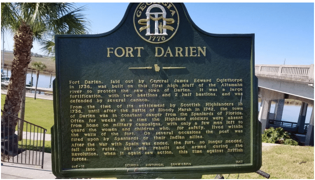
Visit the historic sites such as Fort King George (complete with reenactments), the very first fort built on Georgia’s soil by the British.

Visit Darien at certain times of the year and you’ll be treated to vibrant festivals held along Darien’s Waterfront Park and along the streets of its newly revitalized downtown area. You will want to visit the Butler Plantation and rice fields, old churches, cemeteries and monuments.
Immerse yourself in a world where flowers bloom in every season, where butterflies and birds abound, and clear, blue skies form the backdrop for ancient evergreen oaks festooned with exotic, hanging moss. In November, the Darien Fall Fest features classic car shows, street vendors, helicopter and boat tours, fun for the kids, and musical entertainment.
There’s something new to see and do around every corner.

You might even find yourself listening to or trying to understand another language. That’s right, Gullah is a unique creole language spoken along the Sea Islands and adjacent coastal areas of South Carolina and Georgia. The residents in these areas of Georgia are typically referred to as “Geechee”. Gullah language began as a simplified form of communication among people of different languages including Europeans and diverse African ethnic groups. The vocabulary and grammatical roots come from European and African languages. Gullah Geechee language is the only distinctly African creole language in the United States and has influenced traditional Southern vocabulary and speech patterns. The culture and fascinating history and lives of the Gullah Geechee folks are an important part of this area of Georgia. You can learn more here: https://gullahgeecheecorridor.org
Want to get off the boat for a few days; enjoy a long warm shower after a day of sightseeing around Darien and surrounding area; then sink into the charm and comfort of the Darien Waterfront Inn Bed and Breakfast. Enjoy sitting on the porch and let the gentle breezes soothe your soul. JoAnn Viera offers this relaxing, renewing, river front sanctuary, for your enjoyment. They also offer free shuttle service to the grocery store so you can re-supply before continuing on.
https://www.darienwaterfrontinn.com/

If you need supplies, the First Georgia Hardware and Marine Supply store is only a few hundred yards from the Darien Waterfront Docks and Park.
Fresh produce and seasonal favorites are available within a very short walk to “Turnip Greens Country Market”. You just can’t beat fresh !

Speaking of “fresh”, if you want a break from preparing meals, you are in for a treat, as there are a number of places to enjoy fresh, local dishes prepared only as these fine folks can do. Just to mention some that others have spoken favorably about are the, Waterfront Wine & Gourmet, Blue Bay Mexican, B&J’s Seafood, and Skipper’s Fish Camp.
There are floating docks at Skippers and the first 48 hours are free. No water or electric, but we did say “free” for 48 hours. Puts you right at the kitchen door, almost on their riverfront porch. Skippers Fish Camp is located just under and on the west side of the Highway-17 bridge. It is, a great place to meet and make new friends while dining in this wonderful down-east, coastal town atmosphere.

Be sure to check out the bar and table tops, fashioned from timbers that had been floated down the Altamaha River from the interior during Darien’s days as a major port for timber export in the late 1800s. These milled timbers, salvaged from Brunswick, Georgia’s Oglethorpe Hotel, were saved and used as double flooring in Skippers Seafood Company’s legendary “poker shack”. The Oglethorpe Hotel was used in the Hollywood movie, The View from Pompeii’s Head. So, when you eat in the restaurant or hoist a cool one at the bar, you will be enjoying Georgia history and Hollywood history as well!


Here’s what some of those who’ve visited by boat have said about the good times they enjoyed during their visits to Darien:
Darien is a very pleasant side trip off the AICW, located 7 miles west of the AICW between Dolby and Altamaha Sounds at about MP 651. Turn into the Darien River at AICW Red 184, keeping it to port when turning into the river. Once past this point, markers are red-right-returning. The river is generally wide and deep. Pay particular attention to Red 12 and nearly adjacent Red 14, as their position in the river looks like they should be green, but they are RED. Keep between them and the nearby south bank. The rest of the trip is straight forward. Keep to the outside on turns and watch for floating vegetation. The outside of the last dock is usually open for transients and can handle large boats, depending on room at the time. Call ahead at 912-437-6659 to check availability. Approach to the facing dock into the current is easy and if you call ahead, Dockmaster Wyn will catch your lines. If you like the lowlands, this is a beautiful and wild stretch. The town is delightful and within a few blocks of the floating docks. Plenty for cruisers to do for a couple days. Because it can take some time to get there, depending on direction of the current. Darien is best as a visit destination and not a quick stopover along the AICW, at least for us slow boats. Darien rates are a dollar a foot including water and 30 amp electric, and I was told they will soon have free bicycles for use of overnight guests. Fuel is available at a nearby service station.
Frederick B.
Found plenty of water on the Darien river. Chose to dock here to wait for tide to transit Little Mud creek.
It is 7 miles up the river, but was more than worth it. The volunteer dockmaster was very friendly and
helpful. Dinner at Skippers was great and the best Key Lime pie ever!…………. A. B.
We just spent a couple days on the town dock in Darien GA… This town is very boater friendly and the
people were welcoming. We received a complimentary glass of wine one night while visiting the
Waterfront Wine & Gourmet, who also had live entertainment and a great wine selection. We ate some of the best shrimp we’ve tasted at B&J Seafood. We visited King George Fort and the Rice Plantation.
Well worth a visit. A must do!… R & T
A quaint shrimping town N of Brunswick and well worth the stop… Floating concrete docks are
conveniently located right downtown…. Great food within walking distance – we’ve tried Skippers, B&J’s,….. all outstanding. Fort King George is an interesting historic site and the town has great bicycle trails around the perimeter of the city and within. The historic Butler rice plantation is 1 mile south,
Piggly Wiggly is 1.2 miles away, and a well-stocked Hardware/Marine Supply store is a couple of blocks away…W and R
For our boating friends, coming by water, check your charts and you will see that the Darien River offers plenty of depth most of the way. There are some skinny places as you get up river, but doable. I would recommend traveling on no less than half-tide rising. Here’s a chartlet from Cruisers Net, https://cruisersnet.net/


when turning into the river. Once past this point, markers are red-right-returning. The river is generally wide and deep. Pay particular attention to Red 12 and nearly adjacent Red 14, as their position in the river looks like they should be green, but they are RED. Keep between them and the nearby south bank. The rest of the trip is straight forward.
If you cannot come by sea, then please do so by land. Take time to enjoy a very special slice of down-east, coastal Georgia’s hospitality. Just a hop, skip, and jump off Interstate 95 and you are in the heart of Darien. Take exit 49 off I-95 onto Georgia State Highway#251 which leads you into US Hwy 17 and you are there.
Now that you know a little more about Darien, you are invited to visit and take a closer look at this very special place and enjoy some of its unique offerings. You will remember Darien as one of those towns where you had a great time and created new memories. Here’s a link to their website, take a look and plan this Fall to visit Darien.
http://www.cityofdarienga.com/en/ct-menu-item-15/ct-menu-item-21
© Salty Southeast Cruisers Net, LLC
Click Here To View the Georgia Cruisers’ Net Marina Directory Listing For Darien City Docks
Click Here To Open A Chart View Window, Zoomed To the Location of Darien City Docks


Be the first to comment!