Rediscover Wright Brothers National Memorial, Kill Devil Hills, NC

| ||||||||||||||||||||||||||||||||||||||||||||||||||||||||||||||||||
|
| ||||||||||||||||||||||||||||||||||||||||||||||||||||||||||||||||||
|

A longtime CRUISERS NET SPONSOR, historic Edenton always has an exciting calendar of events! Edenton is at the mouth of the Chowan River on the northwest shore of Albemarle Sound.
|
Our thanks to Southern Boating and Ed Tilletts for giving Cruisers Net permission to publish Ed’s excellent article on the Outer Banks.

Click here for Inside the Outer Banks by Ed Tilletts, Editor-in-Chief of Waterway Guide Media
Southern Boating

| |||||||||||||||||||||||||||
|
In Pamlico Sound early Tuesday afternoon, near Cedar Island National Wildlife Refuge in Down East Carteret County, two excavators at each end of a barge strategically placed the day’s load of 700 tons of limestone marl and crushed concrete into the water.

Excavators deploy limestone marl and concrete into the Pamlico Sound Tuesday to build the Cedar Island Oyster Sanctuary. Photo: Jennifer Allen
Click here for: Pamlico Sound oyster sanctuary network continues to grow
CoastalReview.org
Away from the bustling summer crowds, the Cape Hatteras National Seashore’s new “Kayak with a Ranger” program allows participants to get close to and appreciate nature during guided paddles of the salt marshes and waters of Pamlico Sound.

Click her for more: Ranger-guided paddles encourage ecosystem appreciation
CoastalReview.org
Construction of wind turbines off the North Carolina coast could affect birds and marine life, and while scientists and others seek more information on the extent of those effects, those who spoke during a forum last week in Wilmington said climate change is likely a greater threat.

Offshore wind turbine impacts a trade-off, panelists say
CoastalReviewOnline.org
In addition, the nucs provide power 24/7.
The article states that "The Kitty Hawk WEA and Wilmington East WEA are under lease. These areas have the combined potential to generate upwards of 4 gigawatts of power, the equivalent output of four nuclear power plants." That is not really factually accurate when comparing apples to apples.
It is true that the nameplate capacity of the wind farm and four nuclear plants are both 4 gigawatts. But the capacity factor of a nuclear power plant ( the amount of power it actually produces compared to the nameplate capacity) is 90%. So 4 nuclear plants are capable of producing 3.6 gigawatts of power 24/7, 365 days a year. The average capacity factor of an off shore wind turbine is 45%. So the off shore wind farm is capable of producing 1.8 gigawatts of power 24/7, 365 days a year. A good amount of power for sure, but only the equivalent of 2 typical nuclear plants.
Outer Banks Forever is proud to support our Outer Banks national parks in a variety of ways — large and small.


|
A new exhibit at the Graveyard of the Atlantic Museum reminds us that a vicious German U-boat campaign in the early months of World War II had once raged offshore the barrier islands, setting the sea ablaze and filling the air with explosions.

A simulated view through a submarine’s periscope is included in the new exhibit at the Graveyard of the Atlantic Museum. Photo: Catherine Kozak
U-boat artifacts, divers reveal history of Torpedo Junction by Catherine Kozak
CoastalReview.org
The Dare County Boat Builders Foundation is a non-profit, 501c3 organization dedicated to preserving Dare County’s boat building heritage by actively supporting the students and families within its community.

Click here for more on Dare County Youth Boat Builders Program
Whether you are planning to visit the Outer Banks this summer, or live here and want to get to know our islands a little better, we hope you’ll make time to appreciate and rediscover our parks.

June OBX Park News: Juneteenth Celebrations, Partnership Spotlight, Ask A BioTech, and more!
Cruisers Net has long advised navigation of Oregon Inlet only by shallow draft vessels with current local knowledge.
Oregon Inlet unnavigable by most vessels: Army Corps
CoastalReview.org
A longtime CRUISERS NET SPONSOR, historic Edenton always has an exciting calendar of events! Edenton is at the mouth of the Chowan River on the northwest shore of Albemarle Sound.
| ||||||||||||||||||||||||||||||||||||||||||||||||
|
Click Here To Open A Chart View Window Zoomed To the Location of Edenton Harbor City Docks

A longtime CRUISERS NET SPONSOR, Dowry Creek Marina is owned by the Zeltner family who want to roll out the red carpet to transients, doing whatever you might need during your visit. This highly praised and transient friendly marina lies off the AICW/Pungo River north of Belhaven, NC. This review of Dowry Creek Marina, A CRUISERS NET SPONSOR, is reprinted from Bob Sherer’s review on Bob423.


Click Here To View the Cruisers Net North Carolina Marina Directory Listing For Dowry Creek Marina
Click Here To Open A Chart View Window, Zoomed To the Location of Dowry Creek Marina
Outer Banks Forever is working with our national park staff to coordinate a beach cleanup effort on Hatteras Island in the coming days once road and weather conditions improve.

Cape Hatteras National Seashore Needs Your Help!
For more updates from the National Park Service, please visit Cape Hatteras National Seashore’s News Releases page. |
Thank you in advance for your help, |
 |
Jessica Barnes, Director |
The State Park, adjacent to the Dismal Swamp Canal Welcome Center, has completed maintenance work and is open to the public. The Dismal Swamp Canal Route departs the southbound Waterway at MM 7.2 and the northbound Waterway via the Pasquatank River. Our thanks to Sarah Hill for this report from Dismal Swamp Welcome Center, A CRUISERS NET SPONSOR!
Greetings!
Our friends and neighbors at the Dismal Swamp State Park have reopened to visitors. They have resumed their normal operating hours, which can be found on their website https://www.ncparks.gov/dismal-swamp-state-park/home . For additional information please contact the park staff at 252-771-6593.
Many thanks,
Sarah
|
| Sarah Hill, TMP Director, Dismal Swamp Canal Welcome Center Chairperson, Camden County Tourism Development Authority 2356 US Hwy 17 North, South Mills, NC 27976
|
Washington County’s story is one of isolation, success, and an eventual renewal on the banks of the Roanoke River.
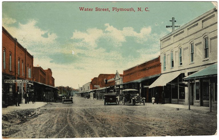
Plymouth Postcard. Source: UNC Libraries
Quiet Washington County rich in coastal NC history by Eric Medlin
CoastalReview.org
The Dismal Swamp Route departs the southbound Waterway at MM 7.2. Your southbound alternate is the Virginia Cut through Great Bridge, VA. Our thanks to Sarah Hill for this report from Dismal Swamp Welcome Center, A CRUISERS NET SPONSOR!
To our Boating Community:
The 17th annual Paddle for the Border event will be held on Saturday, May 7th, beginning near mm28 at the Dismal Swamp State Park paddle launch on the historic Dismal Swamp Canal. We will host about 375 canoes and kayaks launching approximately 8:30am and travel 7.5 miles north to the Ballahack Boat Ramp, in Chesapeake, VA. This event encourages recognition of the historical waterway and its importance to our area. The Dismal Swamp State Park, City of Chesapeake Parks, Rec and Tourism, Camden County, Dismal Swamp Welcome Center, and USACE all collaborate to promote this shared asset between two states.
We love our boaters and know this can be an inconvenience in their attempt to travel the waterway, but this event occurs for a few hours once a year. We’d like to suggest a compromise. Our set up starts early in the morning with traffic crossing the State Park pedestrian bridge for preparations, breakfast and registration at around 6:30am. If you are tied up at the Welcome Center dock, we invite you to join us for a light breakfast at 7:30am and enjoy the view. The launch will begin and paddlers will have cleared out of MM 28 location by 10:30am, heading north. Paddlers have usually made their destination at Ballahack Road by 1 pm.
We want this experience to be enjoyable for all of our waterway travelers. Pulling out early from our dock will also lead you on your way, without any encounters with paddlers. If you are staying at our Welcome Center dock the evening before, we will remind you of the upcoming events in the morning, to assist in your choices.
I hope this message will provide the ability to plan a great day on the Dismal Swamp Canal for all of our guests, paddlers and boaters, alike. On behalf of the Paddle for the Border Committee, thank you for sharing this with your boating partners and please let us know if you have any questions.
Many thanks,
|
| Sarah Hill, TMP Director, Dismal Swamp Canal Welcome Center Chairperson, Camden County Tourism Development Authority 2356 US Hwy 17 North, South Mills, NC 27976
|
For decades, organizations and groups across the country and worldwide have hosted festivals, celebrations and activities as part of Earth Day in an effort to educate the public on the importance of protecting our planet.
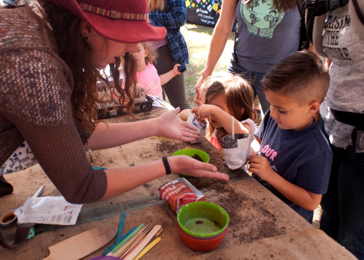
Children enjoy getting their hands dirty during Wilmington Earth Day in 2018. This year’s event will be from noon to 5 p.m. Saturday at Long Leaf Park in Wilmington. Photo: Alan Cradick
Earth Day celebrations abound along NC coast by Jennifer Allen
CoastalReview.org

Bald Head Island is home to Bald Head Island Marina, A CRUISERS NET SPONSOR, found hard by the seaward mouth of the Cape Fear River within sight of “Old Baldy” lighthouse!

Plan Your Spring Get-Away to Bald Head Island
Click Here To Open A Chart View Window, Zoomed To the Location of Bald Head Island Marina


 We’re excited to introduce you to our friends at
 Thank you to everyone who has adopted a sea turtle nest this summer!


Be the first to comment!