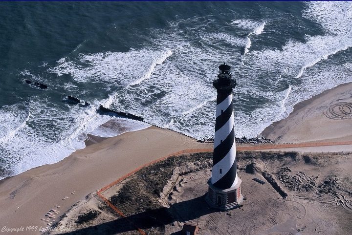
Author, researcher and contributor Kevin Duffus shares his findings that depict the the story of what he calls “America’s lighthouse” and the people connected to it. See also Restoration.
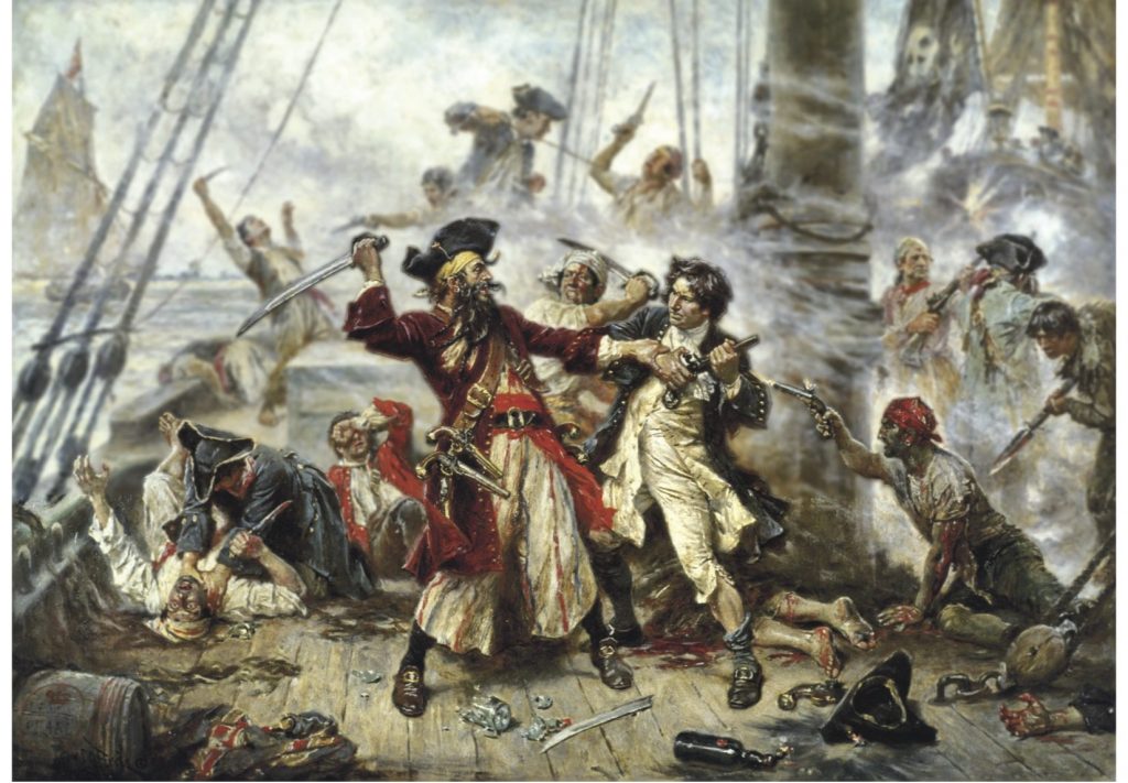
The truth about Blackbeard’s Battle at Ocracoke conflicts with popular interpretations and numerous published accounts, according to author Kevin Duffus.
“Battle at Ocracoke,” painting by American artist Jean Leon Gerome Ferris, 1920.
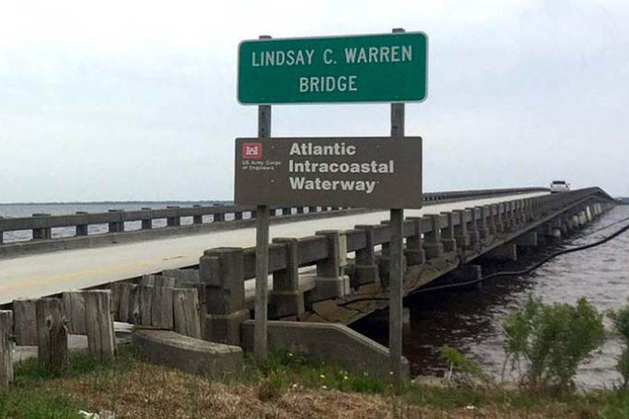
My wife and I once spent a very pleasant three days in Elizabeth City waiting for the winds to drop allowing the long swing bridge to open. The 2.8-mile bridge across the Alligator River has closed several times in recent years to undergo repairs.
This excellent facility and CRUISERS NET SPONSOR, Southport Marina, was severely damaged by Isaias. See Hurricane Damage. As of November 6, they have resumed selling gasoline and diesel fuel.
We’re excited to announce that Southport Marina has resumed gasoline and diesel sales daily, from 8am-5pm. We are monitoring VHF ch. 16, phone 910-457-9900, and email info@southport-marina.com for any questions or needs. Although it will still be some time before we are able to accommodate overnight dockage for transiting guests, we would love to sell you the best quality marine fuel available while you’re in our town. Thank you for your patience while we continue to rebuild our facility! We’re looking forward to the opportunity to serve our customers again soon!
Our thanks to Phil and Karen for sharing their AGLCA Forum posting with our readers. Many of you will travel through Snows Cut at some point in your cruising lifetime. Mile long Snows Cut departs the coastal Waterway at the entrance to Carolina Beach and intersects Cape Fear River at Mile 296.
Living on the ICW, it’s amazing the number of boats we see every day heading south for the winter. 20, 30 a day perhaps, and we only see some of them. Trawlers, sailboats, large yachts and other craft, a few with looper flags but mostly snowbirds. Most loopers know Snow’s Cut, a few miles south of us, as a tricky waterway that connects the Cape Fear River with the ICW at Carolina Beach.
Though interesting, few good photos of this area exist. It’s difficult to get decent photos as you’re transiting it as you’re busy navigating a narrow, tricky channels with a 2 or 3 knot current. On a recent bike ride over the Snow’s Cut bridge, I took a few photos that might give our captains a good overview of the mile-long man-made cut.
Phil & Karen Barbalace
Helms Port
Wilmington,NC
Gold Loopers
Phil Kent and Karen Barbalace
Phil Kent and Karen Barbalace
Phil Kent and Karen Barbalace
Share:
Comments from Cruisers (1)
Winston Fowler- November 6, 2020 - 3:39 pm
Thanks for the great photos… Pictures are certainly worth a thousand words.
An important reminder for our North Carolina locals and for off-shore cruisers. Local knowledge is recommended for most for these inlets.
NC – HAZARDS OF NORTH CAROLINA COASTAL INLETS Hazardous inlets. To heighten public awareness about the hazards that exist in and around the North Carolina coast, this information is provided to mariners. Shoaling conditions exist at following North Carolina coastal inlets: Oregon Inlet Hatteras Inlet Ocracoke Inlet Barden Inlet Beaufort Inlet Bogue Inlet New River Inlet Topsail Inlet Masonboro Inlet Carolina Beach Inlet Lockwoods Folly Inlet Shallotte Inlet Shoaling conditions increase the potential for groundings. These inlets are subject to continual and sometimes rapid environmental changes. Mariners are highly encouraged to obtain the most recent U.S. Army Corps of Engineers Wilmington, North Carolina District hydrographic survey information, centerline waypoints and controlling depth at: http://www.saw.usace.army.mil/Missions/Navigation/HydrographicSurveys.aspx Mariners should use caution when navigating in these areas and passage through the inlets is not recommended without local knowledge of the area. The aids to navigation in these inlets may not be charted and may not be marking best water due to continually shifting shoals. Consult Local Notice to Mariners, 5th Coast Guard District for the latest positions and status of aids to navigation: https://www.navcen.uscg.gov/?pageName=lnmDistrict®ion=5 To report any aids to navigation discrepancies (missing, damaged, off station, extinguished lights), shoaling, hazards to navigation, or discrepancies on bridge lighting, please contact Sector North Carolina Command Center (910) 343-2200.
The North Carolina Estuarium in Washington, A CRUISERS NET SPONSOR, is exploring an essential element — water — with the Water/Ways traveling exhibition, a part of Smithsonian’s Museum on Main Street program.
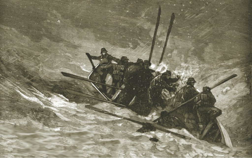
For two days and nights in October 1878, the 11th hurricane of the season thrashed the North Carolina coast and ships offshore, with dramatic ocean rescues and loss of life.
Until his recent untimely death, Robert Peek served as Lockmaster of Deep Creek Lock on the Dismal Swamp Canal for 24 years. See In Memorium Robert Peek. Our thanks to Donna Steward, Director of Dismal Swamp Welcome Center and longtime friend, for sharing this 2012 Facebook article on a typical day in Robert’s life.
The stories of Robert Peek’s “customer relations” are indeed legendary throughout the cruising community. Here is a man who loved his job and did not hesitate to share that love with boaters locking through Deep Creek Lock. Our thanks to Donna Stewart of Dismal Swamp Welcome Center for this notice and to Kim Russo of AGLCA for sharing Robert’s obituary.
Our hearts are heavy, as we mourn the loss of our dear friend and colleague, Deep Creek Lockmaster Robert Peek. Please keep his beloved wife Jackie and family, friends and co-workers in your thoughts in this time of loss. No one will ever fill his shoes.
Robert of Deep Creek Lock squeezed 18 boats in the lock yesterday – we were like sardines in a can. I found the whole thing quite hilarious! Arnold Parkinson
Robert smiling.
Robert getting ready to play his conch shell, for which he was famous. Phil and Karen Barbalace
I am sending this email to inform you Robert Peek who has been the lockmaster at the Deep Creek Locks in Deep Creek Va on the Dismal Swamp Canal died October 1, 2020.
Robert was an icon with the boaters for years. His caring personality and dedication will always be remember. If you could info the boating community through your publication this would be greatly appreciated.
I am Penny Leary Smith (retired) former Director of the Dismal Swamp Canal. Please feel free to contact me for any further information. Thanks.
We first met Robert in 2013 as M/V Yinzer passed through his lock. As we departed the lock, he saw that our Homeport was Pearl Harbor, HI. He picked up one of his conchs and yelled “I bet you know what this is” as he blew it. In Hawaii, in bygone years, the blowing of a conch signaled the coming of royalty. Several years later we took two of our younger grandchildren (ages 8 & 10) on the Albemarle Sound loop and as we returned to the Chesapeake stopped for the night at the free dock located between the Great Bridge bridge and his lock. I told Robert via channel 13 that we were spending the night there and that I had two apprentice conch shell blowers onboard. He naturalling inviting us over for coffee and pastries the next morning. The children took our shells with them. He said that the “blow hole” was too big for the children lips so he picked up a couple of smaller shells and promptly made ones sized for them. We will always remember and cherish the moment.
If you met Robert once, you were a friend. For life. We met, chatted with and were invited to breakfast several times. He was generous with his time, his knowledge and, of course, coffee and danish. Because of storms, dredging and lock repairs we were unable to take the Dismal for couple of years. We were looking forward to seeing Robert this year. Shocked and saddened by this news. It is a terrible loss for the entire boating/cruising community. Our best wishes and condolences to Jackie and his entire family.
You all are in the boating world and know the giant shoes Robert Peek wore for our beloved Dismal Swamp Canal. He was lockmaster, host, grounds keeper, maintenance man, historian, ambassador, entertainer, and most importantly, genuinely caring of his boaters. Everyone was a friend, and he wins a trophy for Hospitality. Everyone knows Robert, and if you didn’t, you wanted to meet him.
So you all know how devastated we are in sharing the news of his sudden death yesterday morning. I like to picture him laughing with God, having a cup of coffee and sweet breakfast treat, debating a few matters and having a good laugh while enjoying the heavenly companionship. I’m sure he has reeled in a few angels who could not stay away from the engaging conversations. Robert is just that way. He was a dear friend, and he will never be replaced.
Please remember his beloved wife Jackie and their family in this time of shock and loss. Also his co-workers at US Facilities and the Norfolk District USACE. If you would like to send any form of condolences please send them to:
Jackie Peek and Family
c/o US Facilities, Inc.
2509 Reservation Road
Chesapeake, VA 23322-5217
We have been assured they will be given to Robert’s family. Jackie has given me permission to tag her on our Facebook page, although we are working out those wrinkles. So anything you share from our page she will have knowledge of. Please feel free to tag us with comments. There are already thousands of people who have seen the post late yesterday afternoon.
Our sympathy goes out to you, as well. We know Robert had many friends in the boating community who are feeling the loss, too. Please feel free to share this message with anyone you feel would care to know. On a personal note, I took this image of Robert when he was assisting with Paddle for the Border, and my husband, daughter and grandson are on the boat with him. His genuine laughter is just contagious, and his conch is front and center. One of my favorites.
A longtime CRUISERS NET SPONSOR, Edenton always has an exciting calendar of events including safe activities during the coronavirus pandemic. Edenton is at the mouth of the Chowan River on the northwest shore of Albemarle Sound.
The popular Cape Lookout Bight anchorage is practically in the shadow of Cape Lookout Lighthouse. In rough offshore weather, cruisers with shallow draft may choose to access the anchorage via Taylor Creek and Barden Inlet which separates Shackleford Banks and Core Banks. These shallow, sparsely marked waters require a constant eye on the depth finder.
Cruisers Net is proud to be a member of the Atlantic Intracoastal Waterway Association whose lobbying work is crucial to keeping the Waterway navigable. Your membership dollars directly support their vital work. Please join and encourage your boating neighbors to do likewise, regardless of their homeport.
AIWA Virtual Annual Meeting ~ November 19, 2020
The Atlantic Intracoastal Waterway Association will hold our Annual Meeting on Thursday, November 19, 2020. We are pleased to present this virtual collaborative event to bring together our members and stakeholders and connect them with federal and state agencies who have leadership roles in managing the waterway.
This one-day schedule format will feature several sessions led by our industry’s leaders and practitioners offering vital information while covering a series of topics for all waterway users. Sessions will include:
State of the Waterway – Management & Maintenance Project Updates from USACE Districts
Updates from our Recreational Boating Community – Boat US, NMMA, MRAA, and others
Beneficial Use of Dredge Materials – New Applications and Directions
Updates to Charting and Mapping efforts along the AIWW from NOAA
Marine Industry and Commercial Operators, Port Authority, Contracting Corporations, and Engineering Design
Shifting to an online virtual platform has its advantages. Even though we all would like to see one another in person, we have the opportunity for increased participation and invite you to share this meeting with your colleagues! This is our annual opportunity to learn more together! If there is a topic or speaker you would like us to consider for inclusion on the agenda, please email AIWA Executive Director Brad Pickel.
Registration is available here for only a $75 investment and we thank you for your continued support, active participation, and look forward to seeing you on November 19th!
Sponsorships and group rates are available. Please email us for more information.
USCG Seeks Feedback on Shallow Draft Waterways
The U.S. Coast Guard is conducting an important assessment of the Shallow Draft Waterways System (SDWS), the fourth in a series of studies to determine the navigation requirements for mariners in the U.S. Marine Transportation System (MTS). The Waterways Analysis and Management System (WAMS) study will help the Coast Guard to determine the Aids to Navigation (ATON) requirements in the SDWS which includes all navigable waterways of the United States less than 12 feet.
AQUA MAP is partnering with the AIWA to offer 20% off their software bundles. We highly recommend the Aqua Map App 🏼 and hope our AIWA members will take advantage of this opportunity. Learn more from Aqua Map by clicking here.
AIWA The Unified Voice of the Waterway ~ Over 20 Years of Advocacy and Education
The AIWA is a national non-profit organization with the mission of securing funding and support for the maintenance of the Atlantic Intracoastal Waterway. We are the only organization dedicated to ensuring the future of the AIWW and proudly represent all stakeholders of the waterway.
Contact: 5A Market, Beaufort, South Carolina 29906 (843) 379-1151
The second in a two-part series by author Kevin Duffus takes readers along with the Cape Fear lifesavers to save the crew from the wreckage of the Charles C. Dame on Frying Pan Shoals.
Author Kevin Duffus takes readers to the 1890s in this two-part series that looks at the U.S. Life-Saving Service and the daring rescues during dangerous storms by its crews on the North Carolina coast.
Oyster lovers will tell you that Carolina oysters are extra special. It is great that these oyster beds in Pamlico Sound are being regrown. The North Carolina Coastal Federation is partnering with the state Division of Marine Fisheries to add 15 acres of new oyster reef habitat in Pamlico Sound.
The beautiful Oak Island area is also home to three CRUISERS NET SPONSORS: Southport Marina, Deep Point Marina and Bald Head Island Marina – three more reasons to visit Oak Island. See Annual Oak Island Lighthouse Run for a rescheduled fall event.
All of these relocated buoys are in the shallow waters near Hatteras Inlet.
CCGD5 BNM 492-20 NC CAPE HATTERAS – HATTERAS INLET (CHART 11555) 1. THE FOLLOWING AID TO NAVIGATION HAS BEEN RELOCATED. A. BARNEY SLOUGH CHANNEL BUOY 3A (LLNR 28721.6 [35°13.4891N / 075°47.2234W, 35.224819 / -75.787057]) HAS BEEN RELOCATED TO APPROX. POSITION 35-13.391N 075-47-14.176W (35°13.3910N / 075°47.2363W, 35.223183 / -75.787271)
CCGD5 BNM 493-20 NC CAPE HATTERAS – HATTERAS INLET (CHART 11555) 1. THE FOLLOWING AID TO NAVIGATION HAS BEEN RELOCATED. A. HATTERAS INLET BUOY 12B (LLNR 28733.1 [35°12.2021N / 075°43.9067W, 35.203369 / -75.731778]) HAS BEEN RELOCATED TO APPROX. POSITION 35-12-11.824N, 075-43-55.492W (35°12.1970N / 075°43.9249W, 35.203284 / -75.732081)
CCGD5 BNM 491-20 NC CAPE HATTERAS – HATTERAS INLET (CHART 11555) 1. THE FOLLOWING AID TO NAVIGATION HAS BEEN RELOCATED. A. HATTERAS INLET CHANNEL LIGHT 19A (LLNR 28765 [35°12.2594N / 075°43.2737W, 35.204323 / -75.721228].1) HAS BEEN RELOCATED TO APPROX. POSITION 35-12-22.182N, 075-43-15.216W (35°12.3697N / 075°43.2536W, 35.206162 / -75.720893) . B. HATTERAS INLET CHANNEL LIGHTED BUOY 12A (LLNR 28732 [35°12.6338N / 075°43.9497W, 35.210563 / -75.732495].1) HAS BEEN RELOCATED TO APPROX. POSITION 35-12-19.060N, 075-43-54.971W (35°12.3176N / 075°43.9162W, 35.205294 / -75.731936) . C. HATTERAS INLET CHANNEL LIGHT 19 (LLNR 28765 [35°12.2594N / 075°43.2737W, 35.204323 / -75.721228]) HAS BEEN RELOCATED TO APPROX. POSITION 35-12-14.587N, 075-43-16.377W (35°12.2431N / 075°43.2730W, 35.204052 / -75.721216) . D. HATTERAS INLET CHANNEL LIGHTED BUOY 12 (LLNR 28732 [35°12.6338N / 075°43.9497W, 35.210563 / -75.732495]) HAS BEEN RELOCATED TO APPROX. POSITION 35-12-36.785N, 075-43-55.362W (35°12.6131N / 075°43.9227W, 35.210218 / -75.732045) .


Be the first to comment!