LNM: Off AIWW, Oregon Inlet Lighted Buoy 13 Relocated
SAFETY/NC – OREGON INLET/ATON/CGD-E BNM 0050-26
1. THE FOLLOWING AIDS TO NAVIGATION HAVE BEEN RELOCATED DUE TO SHOALING. BT |
SAFETY/NC – OREGON INLET/ATON/CGD-E BNM 0050-26
1. THE FOLLOWING AIDS TO NAVIGATION HAVE BEEN RELOCATED DUE TO SHOALING. BT |
Fred Pickhardt’s Substack is free today. But if you enjoyed this post, you can tell Fred Pickhardt’s Substack that their writing is valuable by pledging a future subscription. You won’t be charged unless they enable payments.
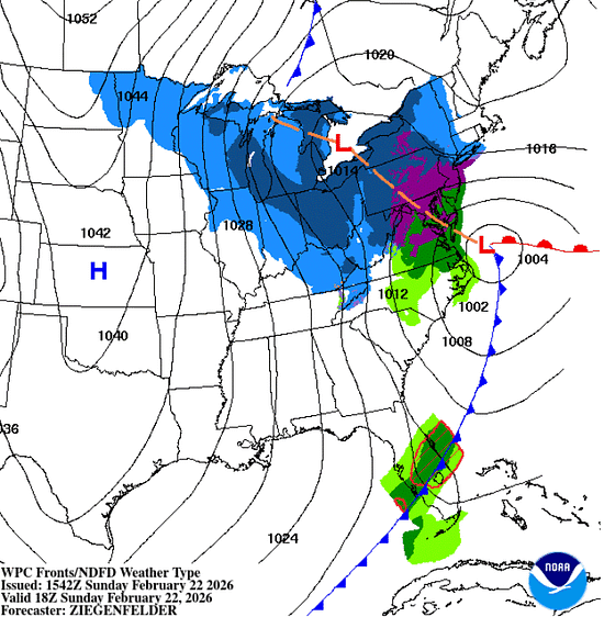
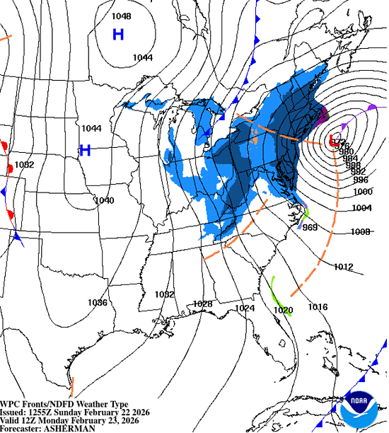
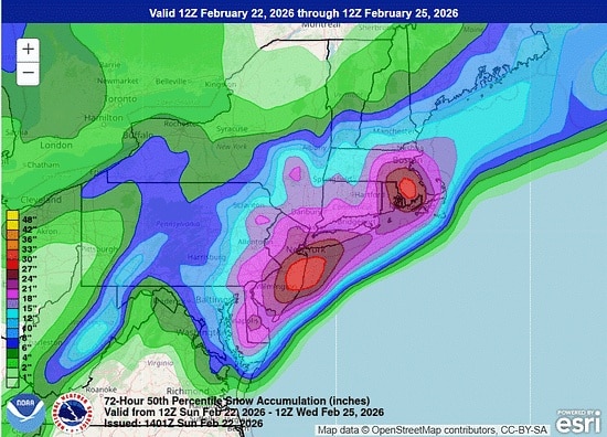
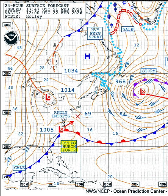
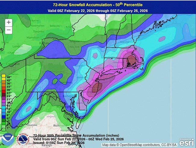
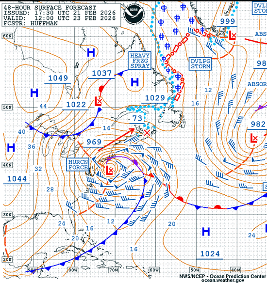
A powerful winter storm, forecast to intensify into a “bomb cyclone,” is expected to create dangerous marine conditions along the US East Coast and Western Atlantic from Saturday through Monday… ![]() Continue reading this post for free in the Substack app© 2026 Fred Pickhardt |
| |||||||||||
Weather Alert – January 29, 2026 | |||||||||||
Snowstorm This WeekendKey Points:
It’s gonna snow this weekend, y’all, with impacts from the storm lingering into early next week. The only questions are how much, and who gets the heaviest. In the meantime:
Uncertainty remains in the forecast, but there is more confidence than before. We can provide you with an accumulation forecast now; here’s what the National Weather Service (NWS) is calling for:
The current questions are about where the heaviest snow falls and how much we all see. The heaviest snow may fall over tomato-and-vinegar country instead of here, though it’s most likely that some of the heavy snow will affect the northern part of the state. The greatest uncertainty for snow amounts is over the Grand Strand and lower Pee Dee region; the ceiling is pretty high there, but the most likely scenario is relatively low. I just did a quick check before sending this out; it looks like the NWS is in the process of increasing the forecast snow for the Pee Dee region, so don’t be surprised to see the forecast for that area being bumped up. Storms like these sometimes cause oddities, such as a large difference in snowfall over a relatively short distance, due to small bands of heavy snow that often form. Don’t be surprised if what falls in your backyard varies a lot from what a buddy of yours 15 miles away sees. The primary impact will be slippery travel, since it’s going to be mainly dry, fluffy snow (parts of the coastal Plain might see a brief period of freezing rain that would make elevated roads slick like a muddy pig). Snow-covered roads will be a problem Saturday through Monday morning, and it’s going to remain cold behind this storm, so the roads could remain slick for a while. How hard it will become to get around and how long the roads remain bad will depend on how much snow falls. If you’re in an area that could see over three inches, start planning to avoid travel from Saturday through at least Monday. Areas to the south are likely to see lower impacts, but travel will be hazardous at least through Saturday and Sunday morning. Bundle up if you go out to play in the snow or if you must be out for work or an emergency; this is among the coldest snow events we’ve seen. The frigid winds will bring a bite, so layer up! Do check your pipes if you didn’t before the last storm to ensure that they’re properly insulated, because it will be at least as cold behind this storm as it was after the last one. What else can you do now? Check out SCEMD’s SC Winter Weather Guide and ready.gov for tips, and go from there. Frank Strait | |||||||||||
|
| |||||||||||
Weather Alert – January 28, 2026 | |||||||||||
Snow Likely This WeekendKey Points:
Another winter storm now looks likely for most or all of the state Saturday into Sunday. There is good computer model agreement that the storm will bring mainly snow, but they disagree on the amounts. Some show a major event with parts of the state seeing over six inches, while others show a peak of only a few inches. In the meantime:
Uncertainties remain because of the complexity of the weather pattern over North America. The primary weather feature is moving southward from Hudson Bay today. It will cross the Great Lakes on Friday and reach the Tennessee Valley on Saturday. It will then move through the Carolinas and depart to the northeast on Saturday night into Sunday. Pacific disturbances now south of Alaska and west of Baja California may join with the storm and add moisture. However, the computer models could be off on the timing of those Pacific disturbances, and they may end up not becoming involved. More available moisture would lead to more snowfall.
This annotated infrared satellite image shows the complexity of our current weather pattern that leads to the uncertainties with this weekend’s potential winter storm:
Image Source: University of Wisconsin RealEarth However, the range of scenarios points to at least a little snow falling over some or all of South Carolina as early as Friday night. Some scenarios would lead to less moisture available, and some would result in the storm not really getting its act together until it’s moving away from us. Others show the storm intensifying by the time it gets here, bringing a major snowstorm that affects most of the state. The truth is somewhere in between, but the model trend over the last day has been toward more snow. You can expect different impacts from this storm than from this past weekend’s, since it’s likely to bring snow rather than thick ice. Also, the snow will be dry and fluffy because it will be so cold, and it won’t adhere well to trees or power lines, so the risk for power outages will be low. Slick roads will be a problem, and it’s going to remain cold behind this storm, so the roads could remain slick for a while. How hard it will become to get around and how long the roads remain bad will depend on how much snow falls. It’s too early to give specific accumulation numbers (that’s coming tomorrow), but the area east of I-77 and north of U.S. 378 has the best chance of heavy snow. If you’re in that area, start planning to avoid travel Saturday through at least Monday. The rest of the state is likely to see lower impacts, but travel will be hazardous at least on Saturday and Sunday. What else do you do now? Check out SCEMD’s SC Winter Weather Guide and ready.gov for tips, and go from there.
Frank Strait | |||||||||||
|
|
A longtime CRUISERS NET SPONSOR, historic Edenton always has an exciting calendar of events and places to visit! Edenton is at the mouth of the Chowan River on the northwest shore of Albemarle Sound.
|
Click Here To Open A Chart View Window Zoomed To the Location of Edenton Harbor City Docks
| |||||||||||
Weather Alert – January 21, 2026 | |||||||||||
Weekend Winter Storm UpdateKey Points:
A map showing the counties under a Winter Storm Watch, highlighted in blue
Good afternoon. A northward shift in the computer model guidance on the track of a winter storm for much of the nation changes the potential impacts here in South Carolina. The forecast for now through Friday night remains unchanged:
Our next storm, currently approaching California, will reach us on Saturday. It has become unlikely that any significant snow will fall in the state (a little at the onset maybe), but sleet and freezing rain are likely to affect much of the state. The computer models continue to show a range of possibilities, but the trend has been our friend, showing less of the state experiencing significant impacts. It would be best to start your preparations soon if you’re in an area that still may be hit by a damaging ice storm and slippery travel. How do you deal with it? SCEMD’s SC Winter Weather Guide is a good starting point, and you can get more tips on winter storm preparedness at ready.gov. Pay close attention to the generator safety and kerosene and propane heater safety tips; carbon monoxide is quite the villain. The picture should get increasingly clearer over the next couple of days as we get closer to the event. Another update is coming on Thursday!
Frank Strait | |||||||||||
|
| |||
|
| |||
A longtime CRUISERS NET SPONSOR, historic Edenton always has an exciting calendar of events and places to visit! Edenton is at the mouth of the Chowan River on the northwest shore of Albemarle Sound.
|
Click Here To Open A Chart View Window Zoomed To the Location of Edenton Harbor City Docks
Keep your calendar clear: Every season in Washington, NC brings something new and exciting. Enjoy local festivals, area concerts, or waterfront adventure.
Click here for the complete calendar: https://visitwashingtonnc.com/events/#/
| |||||||||||
Weather Alert – January 9, 2026 | |||||||||||
Thunderstorms Saturday, Then ColderFor a change, there is a little weather excitement to outline today. A cold front now over the Mississippi and Ohio Valleys is moving our way, bringing rain and thunderstorms, mainly to the Upstate. The front will usher in colder air starting Sunday into Monday. An area of rain and thunderstorms will reach the Upstate this afternoon, primarily affecting the I-85 Corridor and points to the northwest. The rain could become heavy enough to cause isolated flooding in the far northwest, despite the ongoing drought in the area.
The risk for isolated flooding continues through most of Saturday before the rain and thunderstorms shift southeastward.
Thanks to the unseasonably warm air mass in place ahead of the front, we’ll also have a low-end, level 1 of 5 risk of severe thunderstorms in the Upstate and vicinity.
The stronger storms moving through Saturday might cause locally damaging winds, and there is a risk of an isolated tornado or two. In addition, it looks like winds will pick up early Saturday and remain gusty through the day, especially over the northern half of the state, with peak gusts around 35 mph. Motorists and pickleballers beware! Look for a wind shift late Saturday behind the front, and it remains breezy through Sunday. While the severe storm threat drops to near zero as the front reaches the I-20 Corridor during the evening, that area and points south will see a scattering of showers as the front moves through Saturday night. Colder air will move in behind the front Saturday night into Sunday. We will return to the reality of midwinter by Monday as temperatures running around 20° above average through Saturday shift to 4-8° below average on Monday. High pressure keeps us tranquil and seasonable for Tuesday, then another cold front moves in on Wednesday. It is at this point that our forecast becomes complicated. We’ll enter a weather pattern that permits a winter storm to occur in South Carolina late next week. It will be the ol’ western North America upper ridge, eastern North America upper trough; the negative NAO, positive PNA combo that geeky snow lovers rave about. One model (the GFS, the one whose output you take with the biggest grain of salt) has suddenly jumped on the idea that a storm blows up on our coast Thursday as fresh cold air blasts in, and the model throws down snow over nearly the whole state. Sus, as the young folks say these days. Other models show not much happening other than a solid blast of cold arriving Wednesday night and maybe a few showers. However, the cold could still be entrenched when the next storm in line arrives around next Sunday. No promises, snow lovers, but I think our odds are better next weekend than later next week. New Year, New (Old?) Weather AlertI need to pass along a quick programming note. A couple of years ago, we decided to shift from issuing this regularly on Fridays only during hurricane season to year-round. The side effects of doing this made it more like a blog and less like an alert product, and it also forced us to ‘alert’ for several Fridays in a row when nothing truly alert-worthy was happening. So, we’ve decided to revert to the original schedule, where I only create these alerts each week during hurricane season and then send them on an as-needed basis during the rest of the year. So, today’s issuance will be the last regular Friday report until May 29, the Friday before hurricane season begins. That said, there’s a good chance you’ll hear from me next week, since it looks like we’ll have at least one winter storm opportunity in the middle of the month. It may be warm now, but winter’s not over! Frank Strait | |||||||||||
|
| |||
Keep your calendar clear: Every season in Washington, NC brings something new and exciting. Enjoy local festivals, area concerts, or waterfront adventure.
Click here for the complete calendar: https://visitwashingtonnc.com/events/#/
Be the first to comment!