An Update from New Bern Grand Marina, New Bern, NC, off the Neuse River
All,
Millissa here,
I wanted to take a moment to thank everyone for their rock-solid and uplifting feedback regarding how the entire team (staff and or marina community) pooled together to secure the marina for Florence. I’m nothing less than amazed by the support of the local and extended boating community and their genuine concern. Jeremy and team have been tasked with an extensive list of tasks that would frazzle the minds of most, but are relentlessly pushing the marina forward to the next phase of updates an repairs and will assume an aggressive round of replacements and updates in the upcoming months. They are exhausted so please be patient. Not a single one of us would enjoy most of the things they are doing.
Since my client acquired the property, a progressive list of updates and repairs have been made to the marina on a planned schedule, however this next round of updates and repairs may prove to be a bit more extensive as we must seek the counsel of marine contractors. As most would agree, this next phase will ensure our beloved marina continues to be one of the best and most affordable destination marinas in eastern North Carolina, so again, please be patient as we move forward.
Also, all ramps to the docks have now been repaired. All docks are accessible and now also have water.
Remember, through the miry mud of weary tired souls, the best efforts of many will make us grand.
Thank you again for being who you are!
(Please see an important message from Jeremy below)
Millissa
—————————————————————————————————————————————-
Important Message – Hurricane Florence Aftermath Preparation & Instructions
As you come back to the marina please take into account all the work vehicles and trucks in the area. Note-be aware of tripping hazards on the docks as repairs are being made.
Entrance: to the marina and docks: the entry point to the marina will be at the Craven Street walkway. The hotel will be blocked off and there will be a walkway to the marina. This will be the main and only entrance.
ID’s: everyone needs to have IDs to walk around town. The NB police and National Guard will be checking IDs and your reason to be downtown. It’s also recommended to have a document from your boat. I am providing the Police and Hotel staff a list of those in the marina to verify their entry. I will have it to them by tomorrow.
Ramps: I am working on the ramps for F and D dock. I hope to have them up in the next couple days.
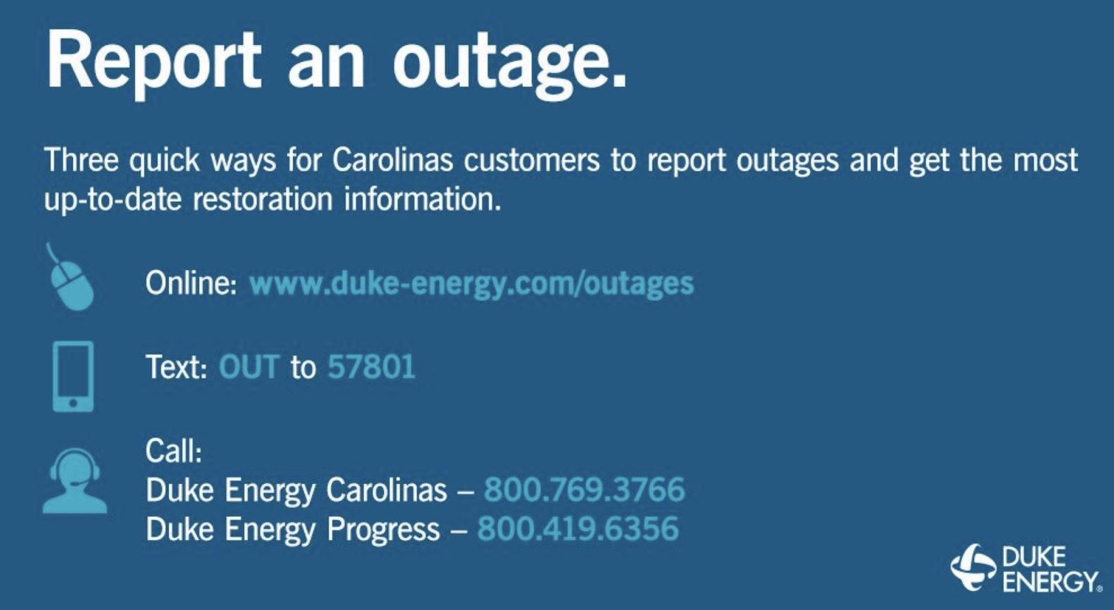
Power: expect power to be off for the next month. I have spoke to the city and we are on the list. All transformers for each dock have been damaged.
Water: I was working on finding the water main today and will continue tomorrow. The main has been covered up by sand, dirt and debris. Unfortunately it’s been a bear to find. I hope to find it soon to assess any damage and effect repair quickly.
Mail/ Packages: all mail and packages will come to the sales office for now. I have advised the postal service and will advised UPS and FEDEX.
We will be here everyday to try and assist with limited hours at the Administrative Office, but will be on the docks and about the marina so please call the cell number posted on the door for assistance. Contractors and adjusters will be around. Please give them room to evaluate, repair, and do their jobs.
Thank you all for your effort, patience, and resiliency. We will do our best to answer any calls, texts, and emails as they come. A current time, we do not have phone or internet service at either office, so please give us time to respond by cell.
Thank you,
Jeremy McConnell

Click Here To View the Cruisers’ Net’s North Carolina Marina Directory Listing For New Bern Grand Marina
Click Here To Open A Chart View Window, Zoomed To the Location of New Bern Grand Marina


Be the first to comment!