Ushering in a New Year on the coast – NC Coastal Federation
|
|

A longtime CRUISERS NET SPONSOR, historic Edenton always has an exciting calendar of events and places to visit! Edenton is at the mouth of the Chowan River on the northwest shore of Albemarle Sound.
101 W King St, Edenton, North Carolina 27932 |
Click Here To Open A Chart View Window Zoomed To the Location of Edenton Harbor City Docks
![]()
Hatteras Island Oyster Roast Tickets on Sale!

Hatteras Island Oyster Roast
February 15, 2025
1 p.m. – 4 p.m.
Our thanks to Ted Arisaka for forwarding this notice from Dec 23 on FB and on Bob423.

Click Here To Open A Chart View Window, Zoomed To the Location of Alligator River Marina
A longtime CRUISERS NET SPONSOR, historic Edenton always has an exciting calendar of events and places to visit! Edenton is at the mouth of the Chowan River on the northwest shore of Albemarle Sound.
 |
| Happy New Year! 2024 was an incredible year in Edenton, and we hope you had the chance to join us sometime throughout the year. From hosting Stage 5 of the Bass Pro Tour to celebrating the 250th Anniversary of the Edenton Tea Party, Edenton’s calendar was packed full of events and activities for all ages! And 2025 is promising to be another incredible year in Edenton. Here are some of the highlights that we hope you’ll join us for during this next year.
This is only a taste of all of the exciting events we have planned during 2025. Check out our Calendar of Events as more events are added regularly. You can also check out our new 2025 Visitor Guide that includes an overview of special events, maps of Edenton and parking, and information on dining and lodging. It’s all the information you’ll need to plan the perfect trip to Edenton! As always, our Bed and Breakfasts are ready to welcome you to Edenton in 2025, and if you haven’t experienced their comfort, convenience, and charm, you’ll want to try their hospitality in this new year. We hope to see you in 2025! |
Erienne Mizell,
Tourism Director
| Visit our website! |
101 W King St, Edenton, North Carolina 27932
Click Here To Open A Chart View Window Zoomed To the Location of Edenton Harbor City Docks
 ON DECEMBER 31ST, A SAFETY ZONE WILL BE IN EFFECT FOR A FIREWORKS DISPLAY ON THE BEAUFORT RIVER ADJACENT TO THE BEAUFORT WATERFRONT. THE SAFETY ZONE INCLUDES ALL WATERS WITHIN A 150-YARD RADIUS OF THE FIREWORKS BARGE FROM 8PM TO 10PM. NO VESSELS OR PERSONS MAY ENTER, TRANSIT THROUGH, ANCHOR WITHIN, OR REMAIN WITHIN THE DESIGNATED AREA UNLESS AUTHORIZED BY ON-SCENE OFFICIAL PATROL. |
Cruisers Net is proud to be a member of the Atlantic Intracoastal Waterway Association whose lobbying work is crucial to keeping the Waterway navigable and safe. Your membership dollars directly support their vital work. Please join and encourage your boating neighbors to do likewise, regardless of their homeport.
| ||||||||||||||||||||||||||||||||
| ||||||||||||||||||||||||||||||||
|
|

|
| Sarah Hill, TMP Director, Dismal Swamp Canal Welcome CenterChairperson, Camden County Tourism Development Authority 2356 US Hwy 17 North, South Mills, NC 27976
|

Every season in Washington, NC, A CRUISERS NET SPONSOR, brings something new and exciting. Enjoy local festivals, area concerts, or waterfront adventure.

A fishing skiff anchored at the North River Bridge in Otway, in Carteret County, is nearly silhouetted at dawn recently. Photo: Doug Waters, coastalreview.org.

Click here for Whales that use echolocation mistake plastic for prey: study
11/08/2024 by Jennifer Allen
CoastalReview,org
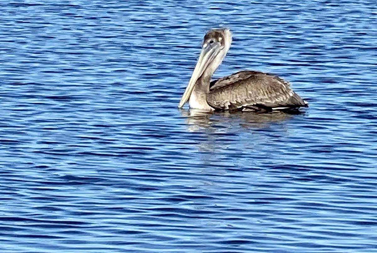
Behold the pelican, its beak can hold more than its belly can. Photo: Gordon Churchill Read more at Coastal Review, coastalreview.org.
Click here for Fishing is for the birds, and they can show you how, where
by Capt. Gordon Churchill
CoastalReview.org

Click here for ICW Follies: Outside We Go to Manteo. Cut That Mark!
NOTE: Unless you have recent and very specific local knowledge, Cruisers Net does not recommend Oregon Inlet.
The Dismal Swamp Route departs the southbound Waterway at MM 7.2 and northbound via the Pasquatank River. Our thanks to Sarah Hill for this invitation from Dismal Swamp Welcome Center, A CRUISERS NET SPONSOR!
Good Morning!
Hope all is well! Passing along some fall images from the Dismal Swamp Canal & Dismal Swamp State Park- we’re starting to see some autumn colors pop up.
Happy to report from recent boaters, very little to no duckweed- no issues. Locks & drawbridges operating on normal schedule.
We’ve put together a few “Know before you go” DSC Boating tips on our website:
https://www.dismalswampwelcomecenter.com/boating-paddling
Please feel free to share.
Many thanks to everyone cruising the historic waterway ~ we look forward to seeing you soon!
Sarah
|
| Sarah Hill, TMP Director, Dismal Swamp Canal Welcome Center Chairperson, Camden County Tourism Development Authority 2356 US Hwy 17 North, South Mills, NC 27976
|


Just pass the canal on 10/29-30 /24. 6 feet of water and wonderful stop at the visitor center. A beautiful trip in a serein environment. No rag weeds. A first for us and I am glad we did it.
Cruisers Net is proud to be a member of the Atlantic Intracoastal Waterway Association whose lobbying work is crucial to keeping the Waterway navigable and safe. Your membership dollars directly support their vital work. Please join and encourage your boating neighbors to do likewise, regardless of their homeport.
|
|

Click here for A Forgotten People: Bohemian oyster shuckers on NC coast
CoastalReview.org

Oriental is home to longtime CRUISERS NET SPONSOR, Oriental Marina and Inn, lying on the eastern banks of inner Oriental Harbor. Our thanks to Bob423 for this information.

Click Here To View the Cruisers Net North Carolina Marina Directory Listing For Oriental Marina
Click Here To Open A Chart View Window, Zoomed To the Location of Oriental Marina

Guests at the Bayview Hotel flock to the sandy bank of the Pamlico River during the establishment’s heyday. Photo courtesy Historic Port of Washington Project Read more at Coastal Review, coastalreview.org.
Click here for Lost riverfront destination, Bayview Hotel nearly forgotten
CoastalReview.org
The Dismal Swamp Route departs the southbound Waterway at MM 7.2 and northbound via the Pasquatank River. Our thanks to Sarah Hill for this invitation from Dismal Swamp Welcome Center, A CRUISERS NET SPONSOR!
Good Morning!
Please save the dates! We’ve got several fall community events planned in Camden County, home of Dismal Swamp State Park, and we hope you will join us to celebrate our local heritage and nature.

*Our Camden Heritage Festival is scheduled for Saturday, September 21st, 2024 from 10am-3pm at Camden Community Park (125 Noblitt Dr., Camden, NC 27921). We are super excited to kick off the day with a performance from the award winning Camden County Bands along with local live entertainment throughout the day. This year’s festivities will include living history re-enactors from the 1st NC Regiment of the Continental Line from Tryon Palace, as we commemorate America 250 NC. We hope you’ll join us for a great community day filled with craft vendors, petting zoo, local business displays, K9 demos, carriage rides, classic cars, food trucks, antique tractors, axe throwing & so much more!

*The Dismal Swamp State Park (2294 US Hwy 17 N, South Mills, NC 27976) will host their 10th Annual Dismal Day event, October 12, highlighting the swamp’s rich natural & cultural history from 10am-2pm. The day kicks off with a 5K Fun Run/Walk along the Dismal Swamp Canal Trail. Don’t miss delicious food, music, wagon rides through the swamp, paddling on the canal, OBX Lizard Land reptiles, craft & activities celebrating the “Year of the Bear”, and educational exhibits.
If you are interested in being a vendor – please let us know. (Camden Heritage Festival Registration ends 8/30/24)
Additional event information coming soon. Please feel free to share, post & print.
Thank you for your continued support and we hope you will be able to join us!
Many thanks,
|
| Sarah Hill, TMP Director, Dismal Swamp Canal Welcome CenterChairperson, Camden County Tourism Development Authority 2356 US Hwy 17 North, South Mills, NC 27976
|


Be the first to comment!