Until his recent untimely death, Robert Peek served as Lockmaster of Deep Creek Lock on the Dismal Swamp Canal for 24 years. See In Memorium Robert Peek. Our thanks to Donna Steward, Director of Dismal Swamp Welcome Center and longtime friend, for sharing this 2012 Facebook article on a typical day in Robert’s life.
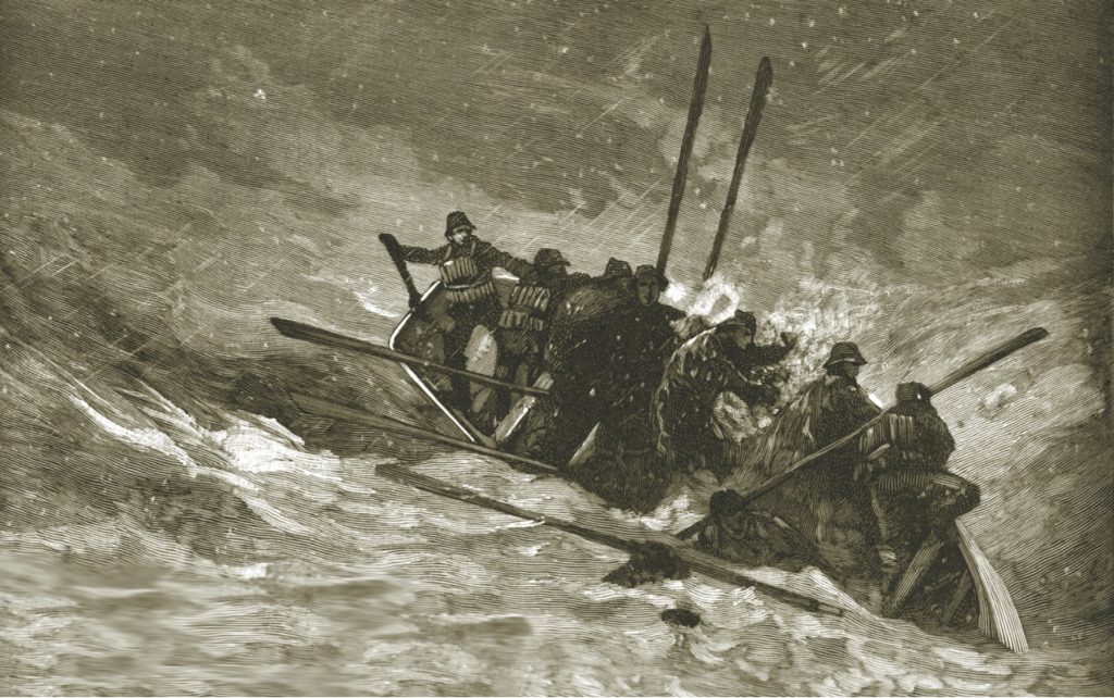
The second in a two-part series by author Kevin Duffus takes readers along with the Cape Fear lifesavers to save the crew from the wreckage of the Charles C. Dame on Frying Pan Shoals.
Author Kevin Duffus takes readers to the 1890s in this two-part series that looks at the U.S. Life-Saving Service and the daring rescues during dangerous storms by its crews on the North Carolina coast.
As steady as the great western rivers of the United States that roll toward the Gulf of Mexico is the Gulf Intracoastal Waterway (GIWW), the nation’s No. 1 energy highway, which follows the coast from Brownsville, Texas, eastward to Carrabelle, Fla. See also History Essay on the Gulf Intracoastal Waterway.
Once the United States entered World War II, the battles fought in the Atlantic off the North Carolina coast changed the way of life for those that called the Outer Banks home.
Yes Bob we know that story. What a period in time. Thanks for reminding us as there are so many who visit and may miss that special resting place for the lads from Britain.
When you have the opportunity to have a meaningful conversation with a skipper who has cruised extensively for over 25 years, who is very familiar with all types of vessels, sail and power, and who created and launched a successful cruising magazine which is still serving the boating and cruising communities… you count your lucky stars. Bill Parlatore is that skipper and the following article addresses some of the things we’ve all faced, and as Bill states, based on attitude at a particular time. Bill has a niche for taking somewhat complex subjects and breaking them down for clearer understanding. The following article addresses the various aspects of preparation for a day, week or months of cruising. It addresses today’s far reaching services driven by technological advances and how to leverage them for simplicity. Our thanks to Bill for sharing his thoughts.
The Florida Fish and Wildlife Conservation Commission (FWC) is reminding the public that it’s waterbird nesting season. Many Floridians and guests are returning to the state’s beaches to celebrate Memorial Day weekend but this is also a critical time for Florida’s vulnerable wading birds, shorebird and seabird populations. By respectfully sharing our beaches and waterways with these birds, people can help ensure their survival.
Least tern chick by Carol Rizkalla/FWC.
Help us conserve beach nesting birds
The Florida Fish and Wildlife Conservation Commission (FWC) is reminding the public that it’s waterbird nesting season. Many Floridians and guests are returning to the state’s beaches to celebrate Memorial Day weekend but this is also a critical time for Florida’s vulnerable wading birds, shorebird and seabird populations. By respectfully sharing our beaches and waterways with these birds, people can help ensure their survival.
Shorebirds and seabirds, such as snowy plovers and black skimmers, build shallow nests on the ground. Their eggs and chicks are well camouflaged and can easily be missed and even stepped on. Wading birds, such as herons, egrets and pelicans, are also nesting now. They typically nest in mangroves and on tree islands around the state. When people come too close to their nests, they can cause birds to abandon their nesting sites, leaving eggs and chicks vulnerable.
“Startling birds might not seem like a big deal, but disturbing shorebirds and seabirds can actually be deadly,” said FWC Florida Shorebird Alliance Coordinator, Shea Armstrong. “If a mother bird is forced to leave her nest, her eggs or chicks are left behind where they can be eaten by predators, exposed to the hot sun, or trampled by unsuspecting beachgoers.”
Boaters and beachgoers can make a big difference for Florida’s vulnerable nesting shorebirds and seabirds by following these simple guidelines:
Keep your distance from birds, on the beach and on the water. If birds become agitated or leave their nests, you are too close. Birds calling out loudly and dive-bombing are signals to back off.
Respect posted areas. When possible, stay at least 300 feet from a posted nesting area. Avoid entering areas marked with signs for nesting birds and use designated walkways.
Do not enter Critical Wildlife Areas. CWAs are established to give wildlife the space needed for nesting, roosting and foraging, and they are clearly marked with signs or buoys to alert boaters to areas that are closed to public access.
Avoid intentionally forcing birds to fly or run. This causes them to use energy needed for nesting, and eggs and chicks may be left vulnerable to the sun’s heat or predators. Teach children to let shorebirds and seabirds rest instead of chasing them, and encourage friends and family to do the same. Shorebirds and seabirds outside of posted areas may be feeding or resting and need to do so without disturbance.
It is best to leave pets at home but if you bring them to the beach, keep them leashed and avoid shorebird and seabird nesting areas. Pets are not permitted on most beaches, including state parks, so always check and be respectful of local rules when preparing for a day at the beach.
Keep the beach clean and do not feed wildlife. Food scraps attract predators, such as raccoons and crows, which can prey on shorebird eggs and chicks. Litter on beaches can entangle birds and other wildlife.
Spread the word. Let your friends and family know how important it is to give shorebirds space and share the message on social media!
Report disturbance of nesting birds to the FWC’s Wildlife Alert Hotline at 888-404-FWCC (3922) or by texting Tip@MyFWC.com. You can also report nests that are not posted to our Wildlife Alert Program.
Once again Greg Allard graciously shares his photographic skills and descriptive writing to help lift our spirits during the pandemic. Thank you Greg.
Rum Cay, a magical place in the southern Bahamas, has always been one of our favorite cruising destinations. Sadly, this is a photo of the dock (and a marina) which are no longer there, damaged by a couple of hurricanes and destroyed by some serious island troubles. (Much too long a story for here.)
Off to the left in the distance, you can see the ocean breaking on the reef which runs along the southern side of the cay; when the marina was open, it was quite a challenge to work your boat through that reef to reach the marina.
NOAA’s National Geodetic Survey (NGS) used the Shoreline Update Expedite (SUE) process to respond quickly to the US Coast Guard’s request to chart an area around the car carrier Golden Ray that overturned in September south of St. Simons Island.
April 24, 2020
Quarterly Newsletter
NOAA certifies San Francisco Bay shipping channel with top survey rating, increasing confidence for deep draft vessel navigation
There is a risk factor when navigating in and out of our nation’s busiest ports, particularly at the helm of some of the world’s largest deep draft vessels. Mariners rely on tide and water level information, wind and weather data, but perhaps most importantly, they rely on electronic navigational charts and the quality of depth measurements that comprise them. Recently, NOAA certified the U.S. Army Corps of Engineers hydrographic surveys for the Pinole Shoal Channel in San Francisco Bay — a critical waterway for bulk carriers and tankers to reach the ports of Sacramento, Stockton, Martinez, and Benicia — the highest possible data quality rating, Category Zone of Confidence (CATZOC) A1, for two years. This is the first USACE federally-maintained channel to receive the highest-level certification. NOAA anticipates the increased CATZOC rating will dramatically increase shipping efficiency.
NOAA works with partners to expand Tampa Bay Physical Oceanographic Real-Time System
NOAA recently expanded the Tampa Bay Physical Oceanographic Real-Time System (PORTS®), working with local partners from the greater Tampa Bay Marine Advisory Council PORTS, Inc. and the University of South Florida. This critical system provides real-time information to mariners about ocean conditions, water levels, currents, and winds. Tampa Bay PORTS has added a new current meter in the main ship channel and a new air gap sensor on the Sunshine Skyway Bridge to help mariners combat strong currents in the area and clear the bridge more safely. The Physical Oceanographic Real Time System (PORTS) is a successful public-private partnership with one or more local partners to install, maintain, and distribute data from real-time tide, current, meteorological, and air gap sensors in areas in or outside seaports that need this information for navigation safety. There are currently 33 systems in place across the U.S. Next year, the PORTS program will be celebrating its 30th anniversary.
Real-time tide predictions and observations for NWLON and PORTS® stations in various seaports are utilized for strict guidance on transit times for deep draft vessels– depending on the tide levels. This data is critical for determining available under keel clearance… a challenge in many seaports. In fact, pilot operating procedure manuals in many areas refer to data and predictions from specific NOAA tide stations, operating in many of our PORTS®.
For example, due to ongoing dredging activities in two ranges in the Delaware River, the Pilots’ Association of the Delaware River and Bay issued temporary and restrictive guidelines that specifically utilize short windows tied to the timing of tide predictions and observations at thePhiladelphia, PA NWLON andMarcus Hook, PA PORTS® stations. This area sees a large daily tide range and the guidance pertains to arrivals and departures for vessels of a certain draft at various pier facilities in PA, NJ and DE.
NOAA announces new progress report on mapping U.S. ocean, coastal, and Great Lakes waters
NOAA collects critical data to aid in hurricane resilience
In the wake of the severe hurricane seasons the past several years, Congress appropriated disaster relief funds to NOAA for the support of “flood mitigation, disaster relief, long-term recovery, and restoration of infrastructure.” With these funds, NOAA has been collecting critical data in areas impacted by each hurricane. Over the next three years, more than one hundred temporary water level gauges will be installed to create decision support tools. NOAA will establish benchmarks at each location creating verified points of reference for assessment. Water level products and tidal datums will be calculated to support accurate tide predictions and safe navigation of coastal waterways marred by the hurricanes. These observations will enhance the network of tidal datums foundational to theVertical Datum Transformation tool (VDatum).
Follow along with NOAA’s chart improvements using new web map service
NOAA released a new and improved web map service featuring the status of NOAA Electronic Navigational Charts (NOAA ENC®) as they undergo major improvements. The current ENC scheme is based on the extents of the paper nautical charts from which ENCs were originally digitized. Improvements to the ENC suite involve replacing this puzzle-piece layout with a rectangular grid of ENCs (referred to as rescheming), often providing larger scale and more detailed coverage than the existing paper charts. The public can now view ENC project status from the planning and creation stages all the way to completion, keeping them better informed of when these enhanced navigational charts will be available. This process was first announced in the National Charting Plan and explained in more detail in the Transforming the NOAA ENC®.
NY Harbor to get updated tidal current predictions
NOAA has recently completed a current survey for the New York Harbor area. Many tidal current predictions in this area date back to the middle of last century to as early as 1885. Updated tidal current predictions are imperative for safe marine navigation throughout a waterway. Each year NOAA measures tidal currents at different coastal and estuarine locations by deploying dozens of temporary instruments, this survey included 36 separate locations. Currents are observed at depths throughout the water column and are measured over a period from one to four months. A statistical process called harmonic analysis determines the part of the current caused by the tides. This “tidal current” can then be predicted at that location for many years into the future. Other factors that influence the current such as wind cannot be forecast for more than a few days and are not included in the prediction. The updated information will be available for mariners to use in 2020. All tidal current predictions can be accessed here.
NOAA helps USCG chart capsized cargo ship along Georgia coast using SUE expedited process
NOAA’s National Geodetic Survey (NGS) used the Shoreline Update Expedite (SUE) process to respond quickly to the US Coast Guard’s request to chart an area around the car carrier Golden Ray that overturned September 5 soon after leaving the Port of Brunswick, about 70 miles south of Savannah. The ship’s 24 crew members were all successfully rescued.
SUE is a process created by NGS to respond to quickly to a high priority navigation issue. This request was one of 84 requests since SUE’s inception in 2018. This request was received at NGS on January 21, 2020 through Coast Survey’s Nautical Data Branch (NDB) via the Southeast Navigation Manager and was completed by NGS in under two hours. The wreck is shown below and is located in Brunswick Harbor, GA at: 31°07’40.80″N, 081°24’10.80″W. NGS provided a shapefile to Coast Survey to overlay on NOAA Nautical Chart 11506.
During the SUE process, NGS acquires existing high resolution imagery from a variety of sources, analyzes and improves the georeferencing accuracy of the imagery if necessary, then quickly creates a shapefile depicting the new/changed feature(s) using NGS’ standard C-COAST attribution scheme, and delivers a shapefile to NDB for immediate application to the nautical charts. The port of Georgia (Savannah and Brunswick) is the fourth largest by total volume and Brunswick is considered the busiest seaport for automobile imports in the US. Thus, this request is considered a high priority. For previous articles on SUE please see Coast Surveys’ 2018 blog.
In mid-April, NOAA co-hosted the first entirely virtual Texas Coastal Ocean Observing Network Meeting (TCOON) along with our partners, the Galveston District US Army Corps of Engineers (USACE). This was the first time this meeting was held virtually due to the COVID-19 Pandemic. NOAA partners with the USACE and the state of Texas (Texas General Land Office (TGLO) and the Texas Water Development Board) to manage and operate a coastal ocean observing network that considers federal, state and local observation requirements for a variety of coastal projects and products and leverages the partnerships capabilities and resources toward meeting them. It’s an impressive collaborative network made up of 6 NOAA National Water Level Observation System stations, 28 TCOON stations, 2 NOAA current meter stations, and four NOAA Physical Oceanographic Real-Time Systems that provide the Texas coast with integrated data to support navigation, emergency response, coastal inundation, marine boundaries and resilience planning. This annual meeting is a venue for marine navigation stakeholders in the Texas region to convene and discuss critical regional issues, opportunities for collaboration and implementation success stories.
New Great Lakes water level information available on NOAA Tides and Currents website
Great Lakes partners and stakeholders will now have access to the record high and low water level for each NOAA Great Lakes National Water Level Observation Network station on the NOAA Tides and Currents website.and can use this information as a reference during this spring and summer season which is forecast to continue with high water conditions. NOAA has analyzed historical data for each of its Great Lakes water level stations and provided this information on each station’s homepage, like this onefrom Ludington, Michigan. The overwhelming majority of these stations reached their highest levels on record in 2019.
The activism ignited by the 1969 spill off the coast of Santa Barbara, California, helped spur the first Earth Day, celebrated by 20 million Americans across the country.
Earth Day and Our Sanctuaries
On January 28, 1969, a blowout on an oil drilling platform six miles off the coast of Santa Barbara, California, spilled an estimated 3 million gallons of crude oil into the ocean. The massive spill shut down commercial fishing, fouled beaches, and killed a great number of dolphins, sea lions, seals, and more than 3,600 seabirds. At the time, the disaster was the largest oil spill in U.S. history. Americans witnessed the oil-coated animals’ suffering on live television and reacted with a new intensity of environmental concern and activism. The event, horrific as it was, marked a turning point in the nation’s conservation history. The activism ignited by the spill helped spur the first Earth Day, celebrated by 20 million Americans across the country. It also built bipartisan support for landmark laws to protect our ocean and Great Lakes. One of those laws was the Marine Protection, Research, and Sanctuaries Act passed in 1972.
The 1969 Santa Barbara oil spill. Photo credit: USGS
The breadth of life in our ocean and Great Lakes is truly astounding. A healthy planet is essential to our health, well-being, and economic livelihood. Nature provides the clean air we breathe, the fresh water we drink, the food we eat, the medicines we take, and the raw materials we use. It mitigates carbon emissions that cause global climate change. Globally, scientists estimate that nature provides services worth $125 trillion per year. The ocean contains a multitude of wonders yet to be discovered, including potentially life-saving cures. The possibilities of new vaccines and medical therapies underscore the importance of conserving biodiversity in these largely unexplored ecosystems.
Safeguarding biodiversity and building a sustainable global economy that protects our blue planet is critical to people’s health and well-being. This year, Capitol Hill Ocean Week will focus on protecting the amazing biodiversity of our ocean and Great Lakes. Throughout the world, we are losing species diversity, with harmful consequences for humans, economies, and the environment. But there are solutions if we work together as stewards of these places. Scientists, managers, and governments are calling for countries to work together to protect nature and to reduce the loss of diversity, slow climate change, and increase our ability to adapt to it.
Our current sanctuaries and monuments are an essential part of this global effort to protect nature. However, there is more we can do. With jurisdiction over almost 4.5 million square miles of ocean – an area 23 percent larger than our nation’s landmass – the U.S. plays a critical role in protecting our global ocean. These waters span ecosystems from the icy cold, gray waters of the Arctic to the warm, tropical blue waters of the Caribbean Sea. By designating new national marine sanctuaries and marine national monuments in areas that represent unique marine and freshwater ecosystems and expanding existing ones with strengthened protections for biodiversity, we can do our part in the global effort to maintain the health of our ocean and Great Lakes.
Blue whales in Channel Islands National Marine Sanctuary. Photo credit: NOAA
Today, nearby the site of the Santa Barbara oil spill is Channel Islands National Marine Sanctuary, where massive forests of kelp shelter a diversity of marine life. Private entities, local communities, the state of California, and the Chumash Tribe are working in partnership with the Office of National Marine Sanctuaries to manage this protected area. Their work is local; its impacts are global.
I hope you will join us virtually on June 9, 2020 for Capitol Hill Ocean Week to learn more about how we can all contribute to protecting our ocean and Great Lakes. Your partnership and financial support are critical to solving some of our most pressing issues, both above and below the waves. This Earth Day, please consider making a donation to the National Marine Sanctuary Foundation in honor of our national marine sanctuaries and monuments, and be part of the solutions to come.
If you have not read and viewed Greg and Barbara Allard’s wonderful photo journals, then let this latest “Letter” be a primer, to be continued by exploring the beautiful “Letters from the Bahamas.” Simply enter “letters” in the search window of our Homepage. During this time of lock-down and social distancing, these letters are sure to help cure your cabin fever! As usual, Cruisers Net is so grateful to the Allards for sharing their experiences with us.
Hi Everyone – We had planned to make our annual voyage to the Bahamas. We provisioned the boat, and headed east across the state of Florida in February, using the Okeechobee Waterway. The Waterway saves about 150 miles; otherwise we would have to travel down the entire west coast of Florida, cross through the Keys, and then back north, up the east coast.
The Okeechobee Waterway has several parts: two rivers, the (Caloosahatchee and the St. Lucie), plus several stretches of man-made canals, five locks, and the huge Lake Okeechobee itself, which is in the center of Florida. The Lake is usually about 12+ feet above sea level, hence the need for locks to raise boats up to the Lake level, and then down again on the other side.
We have made the crossing dozens of time, and find it always a fascinating and intriguing passage. It’s often been described as a time-warp into old Florida.
Once we reached the east coast of Florida in Stuart, the news about the corona virus had intensified, and we decided to forego the trip to the Bahamas this year. That ultimately was a good decision, because as of now the entire Bahamas is locked down, there are significant restrictions on visiting boats, and travel is not permitted from one island to another. We support what the Bahamian government has done to keep their country safe.
After deciding that this was not a good time to leave the U.S., we turned around to head home; this meant we would complete two Okeechobee crossings in one month. So instead of a Letter from the Bahamas, this will be a Letter from Lake Okeechobee, showing you some of what makes us enjoy this old-world part of Florida. We also hope that in your isolation, this will serve as a distraction, however brief, from world events. Yes, we’ll miss the Bahamas, and the water isn’t as beautiful, but that’s just one of many concessions we’ve all had to make to fit in with our changed world.
We sincerely hope that you, your families and your friends are safe and well during these troubled times.
Warmest regards
Greg and Barbara
For those of you unfamiliar with the Okeechobee Waterway, this map is helpful, showing how it cuts through the middle of Florida. You can see the starting and ending points, the distances involved, and well as the location of the locks. Wikipedia reports that Lake Okeechobee is the “second largest natural freshwater lake contained entirely within the contiguous 48 states”.
We’ve done dozens of Okeechobee crossings, but rarely see deer, especially the water’s edge. Her left front leg remained in that position through several photos. I don’t know if she was getting ready to run, or whether she was just posing for the photo. The calm water helped make a fine reflection.
The railway lift bridge is just east of the Port Myacca lock. In this photo it was coming down slowly, so we had to stop and wait for the train. Most things along the Okeechobee Waterway happen slowly. It takes about five minutes for the bridge to come down, the train doesn’t arrive for ten minutes, and once the train crosses (sometimes a long freight train), then there’s a wait for another 10 minutes for bridge operator to decide to raise it. Life is not in a hurry along the Okeechobee.
For those with mechanical interests, in its fully open position, the bridge (lift) section is all the way at the top of the structure; here, it is about two-thirds of the way down. On the left and right sides of the structure, the two rectangular boxes hanging down from cables are the counterweights. They are designed to weigh just about the same as the bridge itself, so that it only takes a relatively small electric motor to raise and lower the bridge since the counterweights have made it essentially weightless.
Fishing along the St. Lucie river. On these two trips, we saw no signs of any algae bloom which on occasion has been evident in the lake and rivers.
Sugar cane is a major crop around Lake Okeechobee, and sometimes the farmers burn the sugar cane remnants to clear the fields and prepare for the next crop. On occasion, the ash from the fires lands on boats, in this case on our deck, surrounding one of our fuel fills.
It’s rare not to see alligators. On this trip we counted over three dozen, including this big guy who is enjoying the sun. Happy that the hull of our boat is thick.
The majestic “Lone Cypress” at Moore Haven; this tree has served as a navigational aid since the mid 1800’s.
These four trees at Belle Glade, draped with Spanish Moss, stand sentinel to the morning sun.
“Resting on her Bones.” This wooden fishing boat has sat on the bottom, at the edge of the Caloosahatchee river, for at least a decade, slowly deteriorating. There’s a story there, for sure.
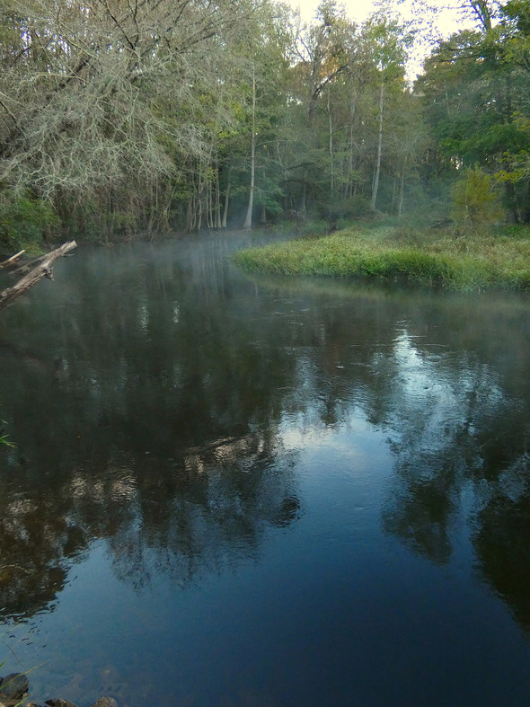
Morning fog on the Caloosahatchee River. (Photo by Barbara Allard)
Goodbye for now. Again, stay safe and healthy.
Greg and Barbara
Copyright 2020, Greg and Barbara Allard
Share:
5 Facebook Likes, 8 Facebook Reactions
Comments from Cruisers (2)
Winston Fowler- April 19, 2020 - 7:09 pm
Greg and Barbara have presented the Okeechobee Waterway in such great detail. There is so much to see and experience on this one-of-a-kind waterway but they have captured the core essence. Well done – thank you.
They have really shown the true essence of this waterway. we have crossed this route dozens of times over the last 11 years and love it. Sadly we have had to sell our boat so all we have left are these sort of memories. Thank You.
From the National Council for Aging Care, the link below lists services ranging from government services, not-for-profit organizations and medical resources.
Bahamas Chatter is produced by Explorer Chartbooks, A CRUISERS NET PARTNER, which has long been the standard navigational supplement for enjoyable, informative, and safe cruising through the beautiful Bahamian waters and island visits.
Bahamas Chatter: New Chart for Bimini Harbour Entrance
The shoal at the entrance to Bimini Harbour continues to move south and has necessitated moving the approach waypoint. Above is the updated section of the approach chart. The channel entrance is still continuing to change and will probably require more updates. Vessels exiting the Bahamas via Bimini should use visual piloting and disregard older charts negotiating the bar here. Buoys are shown in their current positions but it should not be expected that they will remain there or even properly mark the the best approach to Bimini in the future.
The progress made in mapping U.S. waters through 2019 represents the cumulative work of federal and state agencies, nongovernmental organizations, private contracting partners, and crowd-sourced contributions.
NOAA announces new progress report on mapping
U.S. ocean, coastal, and Great Lakes waters
NOAA released the first annual report on the progress made in mapping U.S. ocean, coastal, and Great Lakes waters. Knowledge of the depth, shape, and composition of the seafloor are foundational data elements necessary to explore, sustainably develop, understand, conserve, and manage our coastal and offshore natural resources. The 2019 Presidential Memorandum on Ocean Mapping of the United States Exclusive Economic Zone and the Shoreline and Nearshore of Alaska and the global Seabed 2030 initiative make comprehensive ocean mapping a priority for the coming decade. The Unmapped U.S. Waters report tracks progress toward these important goals.
“The progress made in mapping U.S. waters through 2019 represents the cumulative work of federal and state agencies, nongovernmental organizations, private contracting partners, and crowdsourced contributions,” said Rear Adm. Shepard Smith, director of NOAA’s Office of Coast Survey. “Partnerships and advances in technology are key to making significant progress toward our common goal of completely mapping U.S. waters.”
Pulling from an analysis of publicly available bathymetry, the report presents the percentage of unmapped U.S. waters by region and shows our progress towards filling these basic bathymetry data gaps with each passing year. At the end of 2019, the latest analysis yielded the following results:
Percent of U.S. waters that remain unmapped in 2019:
U.S. total – 54% of 3,592,000 square nautical miles (snm)
Atlantic and Gulf of Mexico – 43% of 472,200 snm
Great Lakes – 95% of 46,600 snm
Caribbean – 42% of 61,600 snm
Alaska – 72% of 1,080,200 snm
Pacific (California, Oregon, Washington) – 24% of 239,700 snm
Pacific Remote Islands and Hawaii – 50% of 1,691,700 snm
Multibeam and lidar surveys are the two primary sources of bathymetry needed to fill these gaps. In support of the integrated ocean and coastal mapping goal to “map once, use many times,” all of the data collected in this effort are publicly available to benefit numerous user communities. For the latest status on these efforts and how you can contribute, visit http://iocm.noaa.gov/seabed-2030.html.
NOAA Office of Coast Survey is the nation’s nautical chartmaker. Originally formed by President Thomas Jefferson in 1807, Coast Survey updates charts, surveys the coastal seafloor, responds to maritime emergencies, and searches for underwater obstructions that pose a danger to navigation.


Comments from Cruisers (1)
It was a very nice person we enjoyed this lock and it is parts of our best lock souvenir. Rest in peace