Safe Harbor City Boatyard, formerly Charleston City Boatyard, a subsidiary of Safe Harbor Marinas, A CRUISERS NET SPONSOR, is found on the northern reaches of the Wando River north of red marker #40.
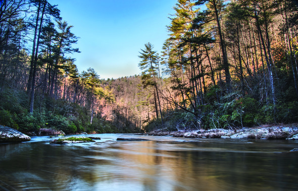
As you can tell from the comments of Charlie and Jackie, Church Creek is a long-time favorite anchorage. Church Creek anchorage lies 18 miles south of Charleston. Church Creek, with 13-22 ft. depths, indents the eastern flank of the AICW’s hard by marker #77.
3-27-2020- back in one of our favorite anchorages- Church Crk, about mm 486.8. We always go farther into crk than most- quieter! Anchor held first time- never dragged here before. Great Verizon, 19 over air TV, normal tidal current, no shopping or dog walking. Plenty of swing room for many large boats. Beautiful view is worth the stop. Some protection from southerly wind- more of a moderate weather anchorage. This is in top 5 of our favorites- been here well over 12 times- and will be back in future. Charlie and Jackie on Traveler.
Dataw Island Marina, a former Cruisers Net sponsor, was completely destroyed by Hurricane Matthew, but has now rebuilt and is open for business (temporarily restricted to day-time only transients and outside dining.) The marina is located just a short distance south off the Waterway via Parrot Creek, then Morgan River, west of marker #6, along the southern banks of the Morgan River. A wonderful, intimate marina and a great stopover!
We are happy to report that the Dataw Island Marina is once again fully operational with fuel, wet slips, dry stack, a restaurant, and a full-service boatyard. The Dataw Island Marina has rebuilt their wetslips and has a fuel once again. Gone are the days of being limited to dry stack. Hooray!!! Laura McCarthy
Windmill Harbour Marina, A CRUISERS NET SPONSOR, is located on Skull Creek, on the shores of Hilton Head Island. As of 5/6 transients are welcome.
EFFECTIVE 5/6/20
MARINA LOCK HOURS OF OPERATION BACK TO NORMAL!
Daylight Savings time hours: 8am – 7pm every day
As usual, Fuel Dock closes 1 hour before the Lock.
Marina office will remain closed until further notice.
Please note the Lock will be closed tomorrow 5/6/20 from 2pm to 3pm for pressure washing and routine maintenance.
Dear Boaters,
I hope this email finds everyone happy and healthy. We have had lots of folks out enjoying these beautiful spring days on the water. Let’s hope this weather continues for a while before the humidity and temperature goes up.
According to the latest updates given by Governor McMaster, he has lifted the “stay at home or work” order. We now feel that it is safe to switch back to normal working hours and start allowing transients back, taking into account the most recent health and safety precautions. We will utilize electronic document signing and take payments over the telephone to continue social distancing guidelines. We are still encouraging self service at the fuel dock for fuel and pump outs. PPE (Personal Protection Equipment) will be utilized by our staff, and we will increase the sanitation of our common areas such as bathrooms and Lock controls. We look forward to serving all of our regular slip owners, slip renters, and transients who love Windmill Harbour as much as we do.
We are hopeful that we have “flattened the curve” as they say, but we should still remain vigilant and abide by proper social distancing measures.
Please do not hesitate to contact me if you have any questions.
Please be advised that there may be a substantial wait time to be Locked back in on each afternoon. Please have patience and understand we are doing our best to get you safely in within a timely manner.
One of a number of Safe Harbor Marinas along the Intracoastal Waterway, Safe Harbor Charleston City Marina, A CRUISERS NET SPONSOR, is located along the Ashley River’s northeastern banks, northeast of marker #5.
South Carolina Department of Natural Resources will keep some properties and facilities closed during SC’s initial easing of restrictions.
—- NEWS RELEASE —-
For Immediate Release
SCDNR to keep some properties, facilities closed
COLUMBIA, S.C. (April 21, 2020) — The South Carolina Department of Natural Resources (SCDNR) will continue to keep several properties and facilities closed until further notice.Those closures include piers at SCDNR’s 13 state lakes, Capers Island, St. Helena Sound Heritage Preserve islands, Fenwick Island, and Botany Bay beach access, as well as Bald Rock Heritage Preserve and Sassafras Mountain Observation Tower.
SCDNR continues to monitor the novel coronavirus (COVID-19) pandemic will make decisions regarding the opening or closing of SCDNR-managed properties with the goal of ensuring the health and safety of staff and visitors as our first priority.
SCDNR remains committed to coordinating a strategic approach to safely reopening these properties and facilities.
South Carolina Department of Natural Resources – Rembert C. Dennis Building 1000 Assembly Street, Columbia, SC 29201
Charleston Harbor Resort and Marina, A CRUISERS NET SPONSOR, sits on the Mount Pleasant side of Charleston Harbor, hard by Patriots Point between Horse Reach flashing buoys #34 and #36.
Charleston Harbor Resort Marina COVID-19 UPDATE
We appreciate your understanding with the following update as we do our best to manage operations through these unchartered waters. Charleston Harbor Resort and Marina will be temporarily suspending service at the Fish House, Reel Bar, Tiki Bar, Estuary Spa, Marina Store, In-Room dining, Guest Transportation, Fitness Center and Harborside beginning March 20, 2020. The Beach Club and Marina remains open for business, (and very limited to-go food service for hotel guests only) and the well-being of our guests remains top priority at Charleston Harbor Resort and Marina. We are always focused on the health and safety of our guests and associates, as well as your experience when visiting the resort. We are closely monitoring the Centers for Disease Control and Prevention and World Health Organization’s statements regarding COVID-19 cases and following guidelines from these agencies as well as local health authorities. In response, we have increased the frequency of our already stringent practices of food and environmental hygiene at our resort. Efforts include increased hand hygiene training, resort-wide sanitization, continuous disinfection and cleaning of high-touch items, general awareness training for all staff members, and more.
In addition to these measures, we encourage you to learn more about what you can do to travel safer. The World Health Organization has several recommendations to reduce exposure to a range of illnesses, including hand and respiratory hygiene as well as safe food practices and check local and federal resources to stay up to date with current affairs.
We are committed to complying with the stringent health standards recommended by local health authorities during this public health situation. Thank you for your understanding and cooperation. At the same time, we are committed to providing a memorable resort experience at the Charleston Harbor Resort and Marina.
For your Upcoming travel to Charleston
Existing Reservations. All reservations that are scheduled for arrival before April 15, 2020 can be changed (you will only be charged the applicable room rate difference) or cancelled at no charge up to 24 hours before your scheduled arrival.
New Reservations. Any reservations that are booked between today and April 15, 2020 for any future arrival date before September 1, 2020, can be changed or cancelled at no charge up to 24 hours before your scheduled arrival.
If you need to adjust reservations made via the Resort website or Reservations Center, please contact the Resort Team directly at 843.856.0028 and select the Resort Reservation option. If your reservation was made through a third party and you need to modify your upcoming reservation, please contact them directly for assistance. As we are responding to the continuously changing state of affairs, please understand that we may make changes to our regularly offered services and we will make every attempt to have all information updated here on our website and on Facebook as soon as possible.
Please contact the resort at 843.856.0028 for the most up to date information pertaining to your stay.
Located on the western shore of the Stono River just south of the Waterway’s passage through Wappoo Creek – Elliot Cut and only a very short cruise from Charleston Harbor, St. Johns Yacht Harbor is A CRUISERS NET SPONSOR!
St. Johns Yacht Harbor is open with reduced hours and manpower. Management office is manned by reduced staff. The store is closed for walk-in sales until further notice. The fuel dock is open from 10AM-4PM daily. Transient and long term slips are still available. For reservations, call 843-557-1027, use Contact/Reservation page on our newly revised website (www.sjyh.com).
This is welcome news for South Carolina residents who often rely on fishing for food rather than sport. This news release clarifies earlier Closures and Cancellations.
—- NEWS RELEASE —-
For Immediate Release
SCDNR’s State Lakes reopening
for bank fishing
COLUMBIA, S.C. (April 2, 2020) — Thirteen of the small impoundments that are in the S.C. Department of Natural Resources’ (SCDNR) State Lakes program are reopening to allow bank fishing. The boat ramps and fishing piers associated with these small impoundments will continue to be closed to comply with Governor McMaster’s Executive Order 2020-16 relating to COVID-19.The 13 small impoundments reopening to allow bank fishing are:
Draper WMA State Lakes (York County)
Jonesville Reservoir (Union County)
Lake Cherokee (Cherokee County)
Lake Edgar Brown (Barnwell County)
Lake Edwin Johnson (Spartanburg County)
Lake George Warren (Hampton County)
Lake John D. Long (Union County)
Lake Oliphant (Chester County)
Lake Paul Wallace (Marlboro County)
Lake Thicketty (Cherokee County)
Lancaster Reservoir (Lancaster County)
Mountain Lakes 1 and 2 (Chester County)
Sunrise (Lancaster County)
Lake Ashwood (Lee County) and Dargan’s Pond (Darlington County) had previously been closed for restocking or repairs and remain closed. Star Fort Pond in Ninety-Six (Greenwood County) is owned by the National Park Service and will remain closed under National Park authority.
The SCDNR’s State Lakes program offers fishing access to the public in areas where public fishing is often not easily available. A list and map of the small impoundments in the State Lakes program is available at: http://www.dnr.sc.gov/lakes/state/index.html.
Members of the public accessing the SCDNR’s properties for bank fishing, hunting, hiking or other recreation are reminded of the need to follow the current recommendations on social distancing and to comply with Governor McMaster’s Executive Order 2020-13 dealing with social distancing and limiting group size or any subsequent orders that may be issued.
South Carolina Department of Natural Resources – Rembert C. Dennis Building 1000 Assembly Street, Columbia, SC 29201
In accordance with directives issued by Gov. Henry McMaster, the Department of Health and Environmental Control and the Center for Disease Control and Prevention, SCDNR has canceled, postponed or closed several programs and events.
Updated Wednesday, April 1, 2020
*New items are bolded
Cancellations & Closures
SCDNR continues to monitor COVID-19. In accordance with directives issued by Gov. Henry McMaster, the Department of Health and Environmental Control and the Center for Disease Control and Prevention, SCDNR has canceled, postponed or closed several programs and events.
2020 Turkey Lottery Hunts – all dates all SCDNR Lottery hunts on WMA properties have been canceled. Sandhills National Wildlife Refuge hunts remain open unless a “Stay Home” order is declared. See: https://www.fws.gov/home/state-by-state-closures.html
Coyote Management Workshop – Webb Wildlife Center (April 2-3)
Fish Brosnan Forest Fishing Rodeo (April 4)
Table Rock State Park Fishing Clinics (April 4 & April 18)
Diversity Outreach Program – Congaree Creek Heritage Preserve Nature Walk (April 11)
Diversity Outreach Program – Volunteer Lab Day at Parker Annex Archaeology Center (April 13)
SC Envirothon Competition (April 24) – Postponed
Blue Hole Recreation Area Fishing Rodeo (April 25) – Postponed
Historic Camden, Kershaw County Fishing Rodeo (April 25)
8 Oaks Park, Georgetown County Fishing Rodeo (April 25)
Charles Town Landing, Charleston County Fishing Rodeo (April 25)
Blue Heron, Jasper County Fishing Rodeo (April 25)
Diversity Outreach Program – Horry County Fishing Clinic (May 1)
Union County Fishing Rodeo (May 2)
Star Fort Fishing Rodeo (May 2)
Croft State Park Fishing Rodeo (May 2)
Darlington County Fishing Rodeo (May 2)
Barnwell Hatchery Fishing Rodeo (May 2)
Peachtree, Horry County Fishing Rodeo (May 2)
Hardeeville, Jasper County Fishing Rodeo (May 2)
Goose Creek, Berkeley County Fishing Rodeo (May 2)
Lake Thicketty Fishing Rodeo (May 9)
Lick Fork Fishing Rodeo (May 9)
Marlboro County Fishing Rodeo (May 9)
Burton Wells, Beaufort County Fishing Rodeo (May 9)
Forrest Hills, Colleton County Fishing Rodeo (May 9)
Black Swamp, Hampton County Fishing Rodeo (May 9)
Academy First Responders Rodeo at Lake Cooley (May 9)
Diversity Outreach Program – Margaret H. Lloyd (Camden) Nature Hike (May 23)
Sun City Grandparents Park Fishing Clinics (May 16, June 20, July 18)
Bat netting is canceled until further notice.
All volunteer lab days at Parker Annex Archaeology Center are canceled until further notice.
All Trailer and Take One Make One (TOMO) events are canceled until further notice.
Following are SCDNR-related closures:
All public access points to the state’s beaches, as well as closure of all public boat ramps, landings and other access points on the state’s lakes, rivers and waterways.
Sunrise Lake, Star Fort Pond, Mountain Lake 1 & 2, Lancaster Reservoir, Lake Thicketty, Lake Paul Wallace, Lake Oliphant, Lake John D. Long, Lake George Warren, Lake Edwin Johnson, Lake Edgar Brown, Lake Cherokee, Lake Ashwood, Jonesville Reservoir, Dargan’s Pond, and Draper WMA State Lakes
All SCDNR freshwater fish hatcheries (still operational, but closed to public)
All SCDNR-managed shooting ranges
U.S. Department of Energy has closed Crackerneck Wildlife Management Area and Ecological Reserve in Aiken County until further notice.
Duke Energy has closed Bad Creek Hydro Project and Musterground Road in Oconee. The Oconee County access to the Jocassee Gorges is closed to vehicles. The gates will be locked until further notice. This also closes some vehicle access points to the Foothills Trail.
At this time, COVID-19 has not impacted season dates or regulations of upcoming hunting or fishing seasons.
South Carolina Department of Natural Resources, Rembert C. Dennis Building
Harbour Town Yacht Basin, A CRUISERS NET SPONSOR, is taking steps to continue serving cruisers and at the same time preventing the spread of COVID-19.
“Harbour Town Yacht Basin is taking transient and monthly dockage reservations. The fuel dock is open with Valvtect gas and diesel, pumpout also available. Restaurants are closed for dine-in, but have take out and will deliver to your boat. Please make a reservation (843) 363-8335 or email: htyb@seapines.com.”
In accordance with directives issued by Gov. Henry McMaster, the Department of Health and Environmental Control and the Center for Disease Control and Prevention, SCDNR has canceled, postponed or closed several programs and events.
Updated Tuesday March 24, 2020
*New items are bolded
Cancellations & Closures
SCDNR continues to monitor COVID-19. In accordance with directives issued by Gov. Henry McMaster, the Department of Health and Environmental Control and the Center for Disease Control and Prevention, SCDNR has canceled, postponed or closed several programs and events.
All SCDNR freshwater fish hatcheries (still operational, but closed to public)
All SCDNR-managed shooting ranges
U.S. Department of Energy has closed Crackerneck Wildlife Management Area and Ecological Reserve in Aiken County until further notice.
Duke Energy has closed Bad Creek Hydro Project and Musterground Road in Oconee. The Oconee County access to the Jocassee Gorges is closed to vehicles. The gates will be locked until further notice. This also closes some vehicle access points to the Foothills Trail.
At this time, COVID-19 has not impacted season dates or regulations of upcoming hunting or fishing seasons.
Wildlife Management Areas, except Crackerneck, are open in accordance with their regular schedule.
South Carolina Department of Natural Resources, Rembert C. Dennis Building
Windmill Harbour Marina, A CRUISERS NET SPONSOR, is located on Skull Creek, on the shores of Hilton Head Island.
WINDMILL HARBOUR MARINA
Hilton Head Island, South Carolina
Okay, you are planning your cruise and you want to really enjoy the beauty of the coastal Carolinas. Checking around you find Hilton Head Island popping up on your radar. In the words of the master Jimmy Buffett, there is this “One Particular Harbor” and this one is Windmill Harbour Marina on Hilton Head Island, South Carolina, one of only three privately locked marina harbors along the east coast of the USA. The best port in a storm or at any other time! Located along the Atlantic ICW at mile marker 558. Need a little more detail? Well, Windmill Harbour Marina is one-half mile south of the Pinckney Island Bridge; 500 yards south of Green #27 channel marker and one-half mile north of Green #29 in the Calibogue Sound.
GPS Latitude: 32° 12′ 54.49″ N GPS Longitude: 80° 46′ 59.57″ W
Windmill Harbour is the South Carolina Lowcountry’s best-kept secret as one of the most gorgeous waterside communities around. With its direct access to the Atlantic ICW, Windmill Harbour is the natural home to a variety of different boaters, from small center console fishing boats to larger cruising and sportfishing boats. There is also a significant fleet of Harbor 20s participating in class racing. In fact, there are numerous cruising and sailing activities including the Calibogue Cup, Harbour Town Cup, and Ocean Challenge.
Each year in May, Windmill Harbour Marina hosts Hilton Head Island Boat Show with over 80 boats on display, equipment demonstrations, seminars, live music, and plenty of friendly folks to chat with, supplemented with delicious food and beverages.
There will be over 80 boats on display, equipment demonstrations, seminars, live music, and plenty of friendly folks to chat with, supplemented with delicious food and beverages.
Windmill Harbour welcomes transient boaters cruising along the Intracoastal Waterway. This marina’s lock system is one of its biggest attractions since it offers protection from tides, strong currents, and storms. The marina’s boats are in deep water all day, every day, without an 8-foot rising or falling tide. At Windmill Harbour, there are no half-hour or longer trips in “no-wake zones” to enter or exit the harbor, and you can experience “tide free” docking. The Harbour staff are onsite seven days a week and will welcome you with easy instructions to enter the lock. It will accommodate vessels up to 70-feet long with a beam of up to 19ft. Visitors from cooperating Yacht Clubs can ask for a guest membership for dining at the on-site South Carolina Yacht Club.
Windmill Harbour Marina has all the facilities and amenities to make you feel as “at home” as possible.
High Speed Fueling
Wifi from OnSpot Wifi
Ships’ store
Pump out facility
Easy access to Hilton Head and Savannah Airports
Harborside restrooms and showers
Laundry facilities
Current and tide free docking
Constant 8′ depth
258 slips from 25′ to 70′
15.5-acre harbor
Direct access to Intracoastal Waterway and Calibogue Sound
24 hr security
Yacht sales and brokerage
Transients welcome
Pet-Friendly neighborhood with dog park
Boat slip sales and rentals
Reasonable rates
On-call maintenance includes boat cleaning, engine repair, electronics, and canvas
Home of the elegant South Carolina Yacht Club with fine dining, swimming, tennis, sauna, hot tub, showers, and locker room
Close to supermarkets, restaurants, shopping, lodging, and golf
Upon your arrival you will find yourself nestled in a unique residential environment of southern charm and old Charleston style homes; where you will be greeted and treated with all the warmth of South Carolina hospitality. Windmill Harbour is South Carolina’s Lowcountry’s best-kept secret.
The unique history, breathtaking beauty, and meticulous planning surrounding this unique harbor have made Windmill Harbour a premier marina community in the South Carolina Lowcountry. Its vibrancy and growth are a testament to its founders and its residents.
So, as you start charting your course north this spring, be sure to enjoy all that Hilton Head Island has to entertain you. Set a course that includes some time at Windmill Harbour Marina to enjoy true southern maritime hospitality.
Give them a call now and reserve your spot. Watch springtime in the South burst forth in all its splendor.
Contact Jake McMillan, the Harbourmaster, on VHF Channel 14 or by phone at 843-681-9235 for transient or long term Boat Slip rentals. Or email at windmillharbourmaster@gmail.com
With a closed vertical clearance of 31ft, Ben Sawyer Bridge is the last bridge before Charleston Harbor when southbound. Opened in 1945, the Ben Sawyer Bridge serves as the connection from Mount Pleasant to Sullivan’s Island.
A number of years ago, we were passing through the bridge. I called the bridge operator and asked if she knew she had been voted the best bridge operator by an ICW user group. She was tickled pink, and I told her it was deserved. We have only passed through the bridge a half dozen times or so on our spring-fall migrations, and it was always a pleasant experience (even when I just missed it a couple of times).
Safe Harbor City Boatyard, formerly Charleston City Boatyard, a subsidiary of Safe Harbor Marinas, A CRUISERS NET SPONSOR, is found on the northern reaches of the Wando River north of red marker #40.
The Lowcountry of South Carolina is not only a place, but also a way of life. The next time you travel the South Carolina Intracoastal waterway, take the time to pull into Beaufort, home of Downtown Marina of Beaufort, A CRUISERS NET SPONSOR!
Wounded Nature-Working Veterans is a group of veterans, non-veterans and active duty military personnel run by Captain Rudy Socha, a former Marine turned conservationist. The non-profit volunteer organization is working to cleanup, preserve and protect our coastal environment, particularly from derelict vessels.
Please take a few minutes to support our efforts by buying a $3.99 Sea Turtle beach/boat bag to support our coastal cleanup efforts. Better yet if you can buy 3 or 4 and give them to friends and family as an after the holidays thank you gift. After making your purchase, please share the link. Yes. there is a S&H charge but it will help us continue making a REAL difference. https://www.partycity.com/wounded-nature-sea-turtle-tote-bag-895011.html
Your support for what we do is greatly appreciated.
Your editor’s personal experience with tax officials in Charleston during the five years we lived aboard was very positive. Tax officials were boaters themselves and took every route to keep our taxes correct, especially after having received incorrect tax bills. Let’s hope these new changes will not affect how taxes are calculated.
Changes to county property tax collections will impact SC boat owners beginning in 2020
Columbia, S.C. (Nov. 25, 2019) — As a result of legislation changing the way that counties collect property taxes on boats, in January of 2020, boat owners and buyers in South Carolina will begin to see changes in the way that boat registrations are issued by the S.C. Department of Natural Resources (SCDNR). The changes to the registration process will be phased in over the next three years as current registrations expire and will result in an annual registration process for boats that more closely mirrors the system used for automobiles. The most visible and immediate change for boat owners will be that boat registration renewals will be done on an annual basis, rather than every three years as they are currently. The fee for the new annual registration will be $10 (1/3 the cost of the old three-year fee of $30). Once fully implemented, the annual registration fee will be included on and paid via the boat owner’s county property tax bill, just like SCDMV vehicle registration fees are paid, which should be more convenient for boat owners than getting a separate bill.
Another change is that under the new law, property taxes for boats will be collected by counties in advance (or “prospectively”) for the coming year. Under the old system, property taxes for boats were collected “in arrears,” or for the previous year. Once the property taxes and registration renewal fee for the coming year have been paid by the owner, the county will notify SCDNR to issue a new set of annual registration numbers for that vessel.
These changes to state law were requested by counties to aid them in accurately collecting the property taxes due on boats. SCDNR is currently working with tax collection officials in all 46 counties to help implement the new requirements and ensure that boat registrations are integrated into the new, annual system. It’s important to note that for boat owners with current registrations, those registrations (and the decal and “numbers” issued by SCDNR for their hulls) will continue to be valid until they expire. The new system should also benefit the prospective buyers of used boats, by making it easier to determine if the property taxes on a potential used purchase are current. Buying a boat on which back property taxes are due can cause major headaches when the new owner attempts to title and register the vessel.
Key things for current/prospective boat owners to keep in mind Currently Registered Boats: Current numbers & decals will remain valid until they expire. Counties won’t begin billing current owners for the annual registration until January of 2021, and only then once their current registration is due to expire. So, for a registration renewed in 2019, that owner’s tax bill should not reflect a charge for annual registration until 2022.
Tax Questions: The change to annual registrations may change the look of your yearly tax notice from your county of residence. Counties will begin issuing the new, prospective, tax notices for boats registered within the county beginning in 2020. Individual counties will determine and implement changes to their tax collection processes as directed by the new law. Please note that questions about a boat owners’ individual tax bills MUST be directed to that county’s Auditor or Treasurer’s Office. SCDNR Boating Office assistants will NOT be able to assist owners with questions about their individual tax bills/notices.
Month of Expiration for New Registrations (new boats or used boats coming from out-of-state): New registrations will be based on the DATE OF SALE. For example: Upon registration, a boat purchased in January will receive a title and registration decal valid through the following January, regardless of when the owner applies for the registration (late fees will apply to registrations initiated more than 30 days after the date of purchase). A tax bill for the year covered by the registration will then be mailed by the county, and in subsequent years the county will mail a bill that includes the annual registration renewal.
In-State Changes of Ownership (transfer of an already-registered boat from one SC owner to another): After purchase, the new owner will need to visit their county tax office FIRST to pay the taxes due for the coming year. The new owner can then apply for title & registration in their name using the paid tax receipt and other required documents. (They will need to apply within 30 days of purchase to avoid late fees.)
Current Owners: The expiration month on the vessel’s current decal will continue to be the month that property taxes are due on that boat. For example, if the boat registration expires in June, then both property taxes and annual registration fees for the coming year will be due in June. (Again, current three-year registrations will be valid until the year of their expiration).
Non-taxable Boats Titled and Registered in S.C.: SCDNR will continue to mail renewal notices for boats that are non-taxable (boats that a county has determined have reached the end of their taxable life or dollar threshold). Their expiration month will not change, and the renewal notices will become annual.
Purchasing a Used Boat: SCDNR strongly recommends that prospective buyers research the registration and tax status and any potential recorded liens of any S.C.-registered boat BEFORE purchasing it, using our free online look-up service. Get the facts before you buy! at: http://www.dnr.sc.gov/boating.html. General information and commonly asked questions regarding S.C. boating laws, titling and registration can also be found at this location.
Shopping for boats at the Palmetto Sportsmen’s Classic Springtime is prime time for South Carolinians attending the Palmetto Sportsmen’s Classic and other outdoor expos to shop for good deals on new boats. Both aspiring and current boat owners need to be aware of changes to how boat taxes and registration renewal fees are collected in the Palmetto State that will be implemented beginning in 2020.
South Carolina Department of Natural Resources – Rembert C. Dennis Building 1000 Assembly Street, Columbia, SC 29201
Share:
Comments from Cruisers (2)
James- November 27, 2019 - 5:43 pm
A transient vessel is just that,,,,,,,,,transient. You pull into port, stay a few days, off-load or load cargo, then depart. If you want to live there and avail yourself of government services, then register with the State/County.
What about documented vessels? Do documented vessels have to also be state registered? Documented vessels don't have titles. Is that a problem? What about people who do not own property in SC? What about people who live out of state but have vessel in SC? How long may a vessel be in SC before it is required to register in SC? What is considered a transient vessel?
Cruisers Net is delighted to welcome aboard a new participating sponsor, Shelter Cove Harbour and Marina, on Hilton Head Island. Shelter Cove Marina sits in the center of Hilton Head Island, South Carolina and the marina’s state-of-the-art facilities and comprehensive amenities are complemented by the lowcountry charm of the island. All kinds of water sports and activities may be enjoyed at Shelter Cove Marina, from inshore and offshore fishing charters to sport crabbing, sailing and dolphin tours, sightseeing and nature excursions. The skilled professional staff work hard to ensure that your visit will be most enjoyable.


Be the first to comment!