As manatees return to their summer haunts along the coast, South Carolina Department of Natural Resources (SCDNR) and U.S. Fish and Wildlife Service (USFWS) biologists are reminding residents and visitors to boat carefully and report sightings of these gentle giants online.
— NEWS RELEASE —
For Immediate Release
Boat carefully and report sightings as manatees return to South Carolina
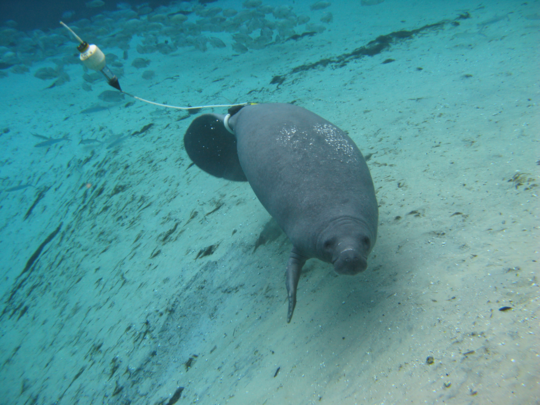
This manatee wears a satellite tag to help researchers track its movements (Photo: Clearwater Marine Aquarium Research Institute)
CHARLESTON COUNTY, S.C. (May 24, 2021) – As manatees return to their summer haunts along the coast, South Carolina Department of Natural Resources (SCDNR) and U.S. Fish and Wildlife Service (USFWS) biologists are reminding residents and visitors to boat carefully and report sightings of these gentle giants online.
Manatees are large marine mammals that reach around 10 feet in length and weigh up to a ton. They’re warm weather visitors in South Carolina, typically arriving in May and leaving by November when water temperatures drop below 68 degrees Fahrenheit. Because of the difficulty of counting them in murky waters, South Carolina’s manatee population is currently unknown – but it’s a small fraction of the United States’ estimated 6,600 animals, most of which live in Florida. Due to federal and state protections, it’s illegal to hunt, play with or harass manatees, which includes touching, providing water to or attempting to feed them.
Biologists with the Clearwater Marine Aquarium Research Institute have been tagging rescued manatees in an effort to study their migration habits outside the state of Florida. A number of tagged animals have already made their way to our waters, including ones bearing satellite transmitters. Tagged manatees wear a “belt” around the base of their tails and trail a floating satellite transmitter that collects and sends information about the animal’s location (see photo). The tags are harmless to the animal and designed to break free in case of entanglement. Officials ask that members of the public do not pull or tamper with these tags – they’re providing valuable information to help wildlife researchers better understand and protect these mammals.
There are several ways members of the public can help South Carolina’s manatees. SCDNR staff encourage anyone to report sightings and provide photographs (if possible) of live manatees online. Photographs of scars on manatees’ backs and tails are particularly useful, because they can often be used to identify previously known individuals. However, manatees should never be approached to obtain pictures.
Injured or dead manatees should be reported immediately to the SCDNR wildlife hotline at 1-800-922-5431. If a boat accidentally collides with a manatee, SCDNR biologists ask that the boater stand by and immediately contact SCDNR or the U.S. Coast Guard on VHF Channel 16. Doing so provides biologists the best chance to help the animal and gather valuable scientific data.
In addition to reporting sightings, coastal residents and visitors can help manatees by staying alert while on the water and avoiding harmful interactions with the animals.
“Feeding and watering manatees encourages the animals to spend time at docks and marinas, making them more susceptible to boat strikes. In addition to being one of the main causes of mortality for manatees, it is also illegal,” said USFWS biologist Melanie Olds. The manatee is protected under federal law by the Marine Mammal Protection Act of 1972 and by the Endangered Species Act of 1973, which makes it illegal to harass, hunt, capture or kill any marine mammal. Conviction at the federal level is punishable by fine of up to $50,000 and/or one year in prison.
Collisions between boaters and manatees are more likely to occur in shallow waters, particularly around docks and at the edge of marshes where manatees feed. Staying alert, following safe boating practices and maintaining lower speeds in these areas can reduce the risk of a collision. Boaters should also watch for manatee backs, tails, snouts and “footprints” – a series of round swirls on the surface caused by a swimming manatee’s tail.
For 44 years, the Florida manatee was protected as “endangered” under the federal Endangered Species Act. In March of 2017, as a result of increasing numbers and improving habitat, USFWS reclassified their status as “threatened.” Manatees are still protected under federal and South Carolina law and face a number of threats on their continued path to recovery. The greatest dangers to the species include boat strikes, entanglement in fishing gear and harmful algal blooms known as red tides.
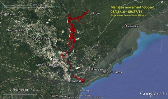
This map shows an example of the location data collected by the Clearwater Marine Aquarium Research Institute from satellite-tagged manatees.
Tips for Being Manatee Friendly in South Carolina:
Dock owners should never feed manatees or give them fresh water. This could teach the animals to approach docks, putting them at greater risk of a boat strike, and it is illegal.
Never pursue, harass or play with manatees. It is bad for the manatees and is illegal.
Boaters should look around for manatees before cranking your boat’s motor and watch for large swirls in the water, or “footprints,” that may be caused by manatees diving away from the boat.
Heed “slow speed,” “no wake” and manatee warning signs, especially around docks. Use caution when navigating in shallow water and along the edge of a marsh. Manatees cannot dive away from boats in these areas.
Wear polarized sunglasses to reduce glare, making it easier to spot manatees below the surface.
To help prepare for the Memorial Day holiday weekend, SCDNR will be holding courtesy boat inspections across the state.
—- NEWS RELEASE —-
For Immediate Release
SCDNR to hold courtesy boat inspections during Memorial Day holiday weekend
COLUMBIA, S.C. (May 24, 2021) — To help prepare for the Memorial Day holiday weekend, the South Carolina Department of Natural Resources (SCDNR) Law Enforcement Division will be holding courtesy boat inspections at public boat landings across the state.
SCDNR officers will perform a quick, but thorough, inspection of your boat to make sure you have the required safety equipment and proper boat and motor registration for your watercraft before you launch. These inspections are completely voluntary and are not required before launching.
Boaters who take advantage of the inspection and are found to not be in compliance with safety regulations or registration requirements will not be ticketed during the complimentary inspections. Instead, boaters will be given an opportunity to correct the problem before they launch their boat.
SCDNR officers will also be available to answer questions and give boaters tips on how to stay safe on the water.
Date
Landing
Time
County
5/29
Johnnie Causey Landing – ICW
10 a.m. to noon
Horry
5/29
Lake Murray Dam
10 a.m. to noon
Lexington
5/30
River Forks Boat Ramp – Lake Hartwell
2 to 4 p.m.
Anderson
5/30
Battery Creek Landing – Battery Creek
10 a.m. to noon
Beaufort
5/30
Easterling Landing – Lake Robinson
11 a.m. to 1 p.m.
Darlington
5/30
Dreher Island Landing
10 a.m. to noon
Lexington
5/30
Ebenezer Park – Lake Wylie
12 to 2 p.m.
York
5/31
Wapoo Cut Landing – ICW
10 a.m. to noon
Charleston
5/31
Alex Harvin Landing – Lake Marion
10 a.m. to noon
Clarendon
5/31
Greenwood State Park – Lake Greenwood
10 a.m. to noon
Greenwood
5/31
Clearwater Cove – Lake Wateree
12 to 2 p.m.
Kershaw
5/31
Dorn Landing – Lake Thurmond
10 a.m. to noon
McCormick
5/31
Twelve Mile Landing – Lake Hartwell
10 a.m. to noon
Pickens
South Carolina Department of Natural Resources – Rembert C. Dennis Building 1000 Assembly Street, Columbia, SC 29201
Our thanks to Ted Arisaka for these reports from SC journalists. See Oyster Farming Dispute.
As you know, in Georgia, the “approved” shellfish harvest areas greatly impinged upon anchorages. Here is an investigative report on alleged conflict of interest in neighboring South Carolina. Ted Arisaka
As much as we might wish to participate, we can’t always put on our gloves and boots and wade into the fray. So here is your opportunity to contribute to the efforts of this fine volunteer group to clean up Charleston’s waterways on our behalf. Please give what you can!
Wounded Nature – Working Veterans needs your help! We clean and rehabilitate critical coastal areas that others cannot reach: Trash/Debris, Treated Wood/Tires, Abandoned/Derelict Vessels.
We make a Real Coastal Difference but doing this requires the right equipment. 2021 is our year to grow and upgrade our 20+ year old boats with two proper workboats. With the right equipment, we will increase our capacity and reach to do more by going after the really tough to get stuff – big treated wood (dock pilings/telephone poles), buried tires, and all the stuff we’ve been seeing but unable to remove to date.
Sharing this fundraiser with your network is just as impactful so please SHARE away to help Wounded Nature – Working Veterans continue to MAKE A REAL COASTAL DIFFERENCE in 2021 and for years to come!
At 90 meters (295 feet) in length, Eagle is the largest tall ship flying the stars and stripes and the only active square-rigger in United States government service.
CHARLESTON, S.C. — The Coast Guard tall ship Eagle, “America’s tall ship,” is scheduled to arrive Friday at the Charleston Cruise Ship Terminal.
WHO: The Coast Guard tall ship Eagle
WHAT: The Barque Eagle is scheduled to arrive in Charleston. Free pier-side exhibits and discussion with officer candidates and members of Eagle’s crew.
HOW: During this time, there will be opportunities to enjoy free pier-side exhibits and discussions with officer candidates and members of Eagle’s crew. Due to COVID safety protocols, public tours onboard the ship are not available at this time.
Barque Eagle will be open for free public tours on the following dates and times:
Friday, March 12
1 p.m. – 4 p.m.
Saturday, March 13
9 a.m. – 4 p.m.
Sunday, March 14
9 a.m. – 4 p.m.
At 90 meters (295 feet) in length, Eagle is the largest tall ship flying the stars and stripes and the only active square-rigger in United States government service. Constructed in 1936 by the Blohm and Voss Shipyard in Hamburg, Germany, and originally commissioned as the Horst Wessel by the German Navy, Eagle was a war reparation for the United States following World War II. Eagle is a three-masted barque with more than 6,797 square meters (22,300 square feet) of sail and 9.7 kilometers (6 miles) of rigging, Eagle has served as a classroom at sea to future Coast Guard officers since 1946, offering an at-sea leadership and professional development experience as part of the Coast Guard Academy and Officer Candidate School curriculum.
Additional information about the Eagle can be found here. The Eagle’s design dimensions can be found here.
The Eagle’s navigator, Lt. Will Singletary, is a native of Charleston and a 2013 graduate of The Citadel.
For a continuous stream of information about Coast Guard Tall Ship Eagle, including port cities, tour schedules, current events, as well as cadet and active duty crewmember photographs, follow the “United States Coast Guard Barque EAGLE” Facebook page.
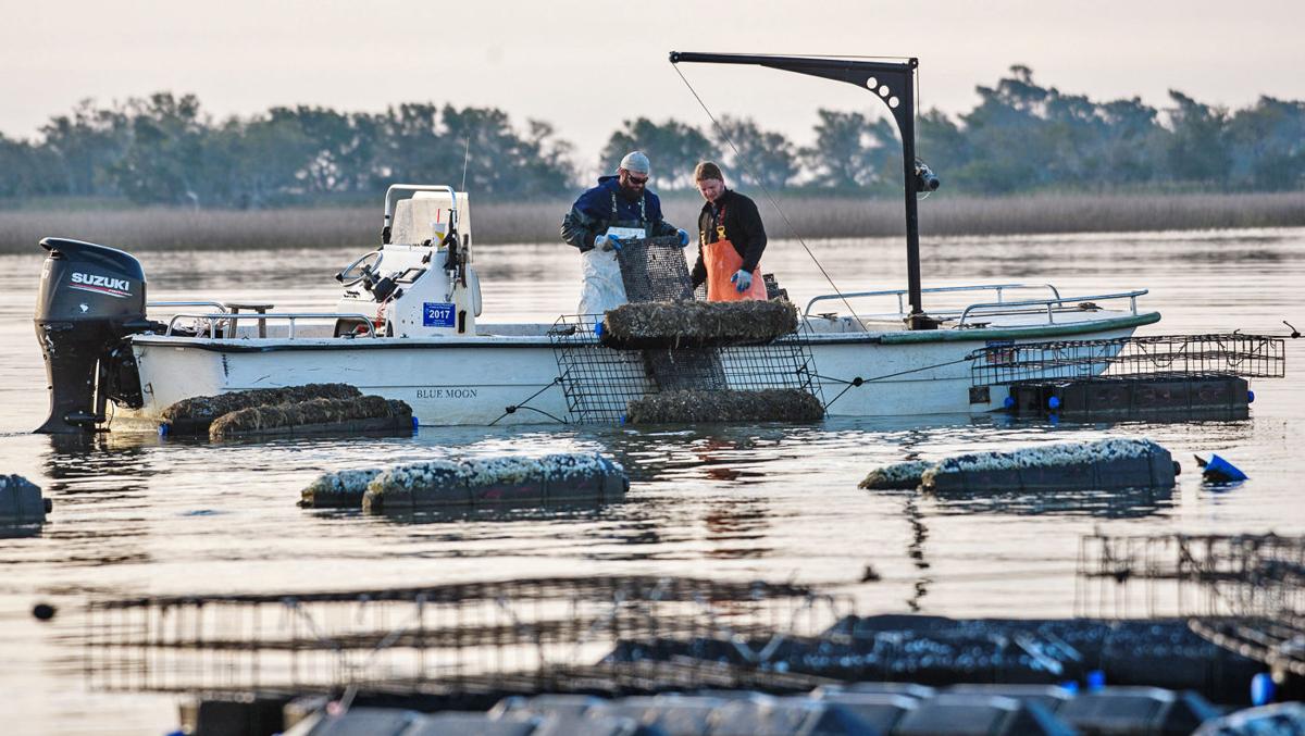
In the recent past, there have been local objections from boaters about these floating oyster beds and their implementation. Many boaters consider the floating beds to be a danger to navigation and a reduction of anchoring space. See Oyster Beds.
Lowcountry Oyster Co. operates one of South Carolina’s five floating-cage oyster farms in the region. Growers say it’s the most reliable way to farm oysters, but some boaters and waterfront property owners are opposed to them. File/Provided
On the fence about Charleston Race Week or the Melges 24 Gold Cup? Are you attending and want to know what to expect and how to stay safe? Join Charleston Race Week and Quantum Sails Monday for a webinar with Regatta Organizer Randy Draftz and Quantum Pro Scott Nixon to get the lowdown and ask your questions. Race Week is April 8-11, 2021, see link below.
On the fence about Charleston Race Week or the Melges 24 Gold Cup? Are you attending and want to know what to expect and how to stay safe?
Join Charleston Race Week and Quantum Sails Monday, March 8 at 4 PM ET / 1 PM PT for a webinar with Regatta Organizer Randy Draftz and Quantum Pro Scott Nixon to get the lowdown and ask your questions.
Still need to register for the Charleston Race Week regatta? CLICK HERE >> Stay tuned for more details on the Melges 24 Gold Cup, formerly the Worlds!
KNOWLEDGE IS POWERRegatta Organizer, Randy Draftz, has spent the last year in close contact with local health officials and the local university to stay on top of the latest info and best practices to ensure when 2021’s Charleston Race Week rolled around, he would be able to give sailors around the country a much needed safe, fun, and exciting regatta.
SAFETY & SOCIAL PLAN DETAILS
As you can image, this event won’t look like Charleston Race Weeks of the past, but that doesn’t mean there won’t be expert knowledge, epic racing, and fun to be had. Randy Draftz and Scott Nixon will discuss the current plans for the regatta including the social scene, debriefs and dock talks, even weather and what to expect in general.
TIPS FOR A SAFE REAGATTA
Quantum’s Scott Nixon and his team have slowly begun campaigning this winter. He will talk through how they and other teams have been able to hit the water safely and share some tips that they’ve learned along the way.
Q&A
There will definitely be questions and Randy and Scott are ready for them. They want to make sure you’re comfortable and confident to head to Charleston and enjoy some time on the racecourse.
Our thanks to Ted Arisaka of Save Georgia’s Anchorages for this information. Such stringent restrictions are almost always passed by officials who are not boaters and do not understand the mechanics of and safety requirements for anchoring. There are 3 recommended anchorages near the Folly River launch ramp, a heavily trafficked ramp with walking distance of downtown Folly Beach. Open Chartview and click the anchor symbol to show the anchorages locations.
Last year Folly Beach passed an ordinance requiring:
1) an anchoring permit for even one night
2) a 1 mile setback from any public boat ramp
3) a 1 mile setback from any bridge
4) other more reasonable setbacks from docks, marinas
#2 and #3 seem excessive. I was able to download the list of boat ramps from SC DNR and map them. You can draw a one mile radius circle around each of these placemarks to see what the impact would be if this were implemented statewide. (and this does not include the bridge setback).
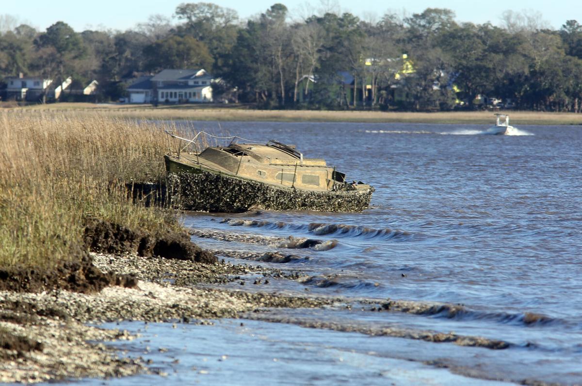
Boaters have long used South Carolina’s public waterways to store or abandon their derelict vessels. If a new bill passes in the General Assembly, they may soon have to take responsibility for them.
An abandoned sailboat rests in the pluff mud of the Ashley River near the Interstate 526 Westmoreland Bridge on Tuesday, February 16, 2021. Brad Nettles/Staff
Between the Winyah Bay Entrance south of the AICW from Georgetown, SC and the Charleston, SC harbor entrance, there is really no safe inlet and Dewees Inlet carries this emphatic warning from Claiborne: WARN ANYONE OFF FROM USING THIS INLET. THERE IS NO CHANNEL TO SPEAK OF AND TO SAY IT’S TREACHEROUS IS AN UNDERSTATEMENT. IT COULD BE DEADLY!!!
We are headed back off-shore to the south – Charleston, but would prefer Isle of Palms as it takes about two hours off the trip… if we can get in through Dewees Inlet. Charts show no marked channel to the outside but inside the water is charted deep (no channel markers), tides run 5+ feet and there are some tempting areas that may not be shoaled up. Does anyone know if this passage can be made safely with a ~6 ft. draw at HT? Thanks Captain Ric
I know this is 10 years after the original post, but stay away from Dewees Inlet! Navionics had me take the outside route from McClellanville to Isle of Palms this morning because of low tide along the ICW. Well, I can tell you first hand that Dewees Inlet made me soil my shorts and need a few beers once inside. The approach consisted of many turns and following that magenta line to the "T". However, there was a northeast wind with swell coming from the northeast and the south. Everything was going fine, I was on the line and then my depth sounder started screaming low water. I draw 4'9" on my 37' Gulf Star and at 6' on the sounder with the swell, I kissed the bottom with the keel twice before finding deep water 100' to starboard (off the magenta line) on the edge of breaking waves. Halfway in I saw two large 40+' sport fishing boats turn around and say "Nope, not today". Water depth went from 30' to 6' in a matter of 100 yards and then back to 30+'. Once in calmer water, there was 40' depths the rest of the way. What a way to test the nerves of a new Captain. Next time, I'll take my chances running aground in the ICW. On a calm day, you might be able to get in or out of here, but I seriously don't suggest trying it.
Shelter Cove Harbour and Marina sits in the center of Hilton Head Island, South Carolina and the marina’s state-of-the-art facilities and comprehensive amenities are complemented by the lowcountry charm of the island.
*Due to COVID-19 protocols, Shelter Cove Harbour & Marina is taking extra precautionary measures to ensure the safety of guests and staff. Boats and equipment are being cleaned with soap and bleach at or above the CDC recommended mixing ratios. The marina Ship’s Store is regularly cleaned with disinfectants while focusing on key areas. Employees are regularly cleaning their hands with soap and hot water to keep them as well as customers safe.
Shelter Cove Harbour & Marina — Hilton Head Island, South Carolina
Hilton Head Island’s award-winning Shelter Cove Harbour & Marina, A CRUISERS NET SPONSOR, is the ideal place on Hilton Head for island fun, shopping and a bite to eat. Situated just off the Intracoastal Waterway — Latitude 32* 10’ 92” N Longitude 80* 43’ 56” W — in the middle of Hilton Head Island across from the renowned Palmetto Dunes Oceanfront Resort, Shelter Cove Harbour & Marina offers year-round waterfront dining, shopping and entertainment, along with water sports, activities and tours — all highlighted by Shelter Cove’s spectacular harbour and sunset views.
With 178 slip rentals, the Mediterranean-style Shelter Cove Harbour & Marina is Hilton Head Island’s largest deep-water marina. Shelter Cove’s state-of-the-art facilities and comprehensive amenities are complemented by the island’s Lowcountry charm. The skilled professional staff work hard to ensure that Shelter Cove maintains its stature as one of the East Coast’s premier boating destinations. Shelter Cove recently received the “South Carolina Clean Marina Certification.”
All kinds of water activities may be enjoyed here, from inshore and offshore fishing charters to sport crabbing, sailing and dolphin tours, sightseeing and nature excursions and more. One of the finest ports of call along the East Coast, Shelter Cove Harbour & Marina is your No. 1 Hilton Head Island destination.
When it comes to water adventure, Shelter Cove is the place to be. Rent a boat, kayak or paddleboard — or try out the popular two-person catamarans. Party-cyle with friends or fish for crabs, Shelter Cove has got it all, from nature & dolphin tours to dinner and fireworks cruises. There’s so much to do on the water at Shelter Cove. Inshore, nearshore and offshore fishing in Hilton Head Island provides some of the world’s ultimate fishing experiences.
Hilton Head is widely considered America’s favorite island, serving up 12 miles of pristine beaches and everything anyone needs for an ultimate coastal retreat. Hilton Head was voted “No. 1 Island in the Continental United States” for the fourth consecutive year in Travel + Leisure Magazine’s 2019 World’s Best Awards. In addition, readers of Condé Nast Traveler have voted Hilton Head Island 2019’s “Best Island in the United States” for the third year in a row.
Hilton Head Island’s weather is ideal for those wanting to explore the outdoors and soak up the sunshine. The Lowcountry region features a mild, subtropical climate all year round. Enjoy easy days relaxing in the sun, sand and surf on some of the best beaches in the country. Hilton Head offers a laid-back and welcoming vibe that makes it a perfect vacation destination. There’s something marvelously different about the warm and welcoming feeling found on Hilton Head Island.
Shelter Cove Harbour & Marina is one of Hilton Head’s most popular attractions, because it hosts impressive local and world-traveled boats and yachts, has many fine restaurants and shops, and is the site of some of the island’s signature annual festivals. These events include HarbourFest, an annual summer-long celebration known for its fabulous fireworks displays on select Tuesday nights from mid-June to mid-August.
**ALL 2020 EVENTS ARE SUBJECT TO CHANGE OR CANCELLATION DUE TO COVID-19 GUIDELINES AND CROWD RESTRICTIONS DETERMINED BY THE TOWN OF HILTON HEAD ISLAND AND OUR SOUTH CAROLINA GOVERNOR. ** Visit ShelterCoveHarbourFest.com for current updates.
Centrally located on William Hilton Parkway (Route 278) East at Mile Marker 8, Shelter Cove’s mid-island location on Broad Creek also makes it a perfect launching spot for other island excursions. But with fireworks during HarbourFest all summer long, there’s no better place to have fun than Shelter Cove. For the weekend or the summer — for locals and visitors alike — there’s plenty to enjoy.
Palmetto Dunes Oceanfront Resort has been a favorite vacation destination for decades, providing one of the richest vacation experiences in the country with more award-winning activities than any other resort in the Southeast. Ranked the No. 1 family resort in the United States and Canada and one of the “Top 25 World’s Best Family Getaways” by Travel + Leisure magazine, Palmetto Dunes features activities and experiences for every member of the family. Visitors and guests can explore Shelter Cove Harbour & Marina, enjoy one of the 2,000-acre resort’s three award-winning championship golf courses, bike along the beach, or kayak the 11-mile inland lagoon system.
GOLF Palmetto Dunes Oceanfront Resort is one of the premier golfing destinations in the Southeast. Each of the three superb layouts are distinctively different, yet challenging. The Arthur Hills Course at Palmetto Dunes, designed by famed golf course architect Arthur Hills, was built on a series of rolling dunes and was named the state’s 2009 Course of the Year. The scenic Robert Trent Jones Oceanfront Course, home to one of the most stunning oceanfront holes in the Southeast, was honored as the South Carolina Course of the Year in 2003 and is a “Certified Audubon Cooperative Sanctuary” for its commitment to providing a sanctuary for wildlife. The George Fazio Course, Hilton Head Island’s only par-70 layout, presents a challenge to any accomplished golfer: a series of long par 4’s guarded by bunkers and water hazards. Veteran golfers regard the Fazio course as Hilton Head Island’s true championship course.
TENNIS AND PICKLEBALL Tennis lovers are able to book their ultimate tennis vacation at Palmetto Dunes Oceanfront Resort on Hilton Head Island, South Carolina, and enjoy tennis court time, lessons, clinics and more daily at the award-winning Palmetto Dunes Tennis & Pickleball Center. Palmetto Dunes offers 19 clay tennis courts, four of which are lighted for night play, and a beautifully well-stocked, 1,800-square-foot tennis pro shop — Hilton Head Island’s largest. Palmetto Dunes also offers 24 pickleball courts, all of which are lighted for night play. The Palmetto Dunes Tennis & Pickleball Center has been named the island’s top tennis resort.
OUTDOOR ADVENTURE Guests may use their complimentary bike rental to explore miles of paved pathways beneath towering live oak trees and three miles of pristine beaches. Hilton Head Outfitters is available for bike rentals, canoes, kayaks, fishing and much more. Fishermen may select a fly rod or light tackle to go after large redfish, trout, bluefish, flounder and black drum. The calm waters of the 11-mile inland lagoon system that runs through Palmetto Dunes present countless opportunities for fishing, bird watching and enjoying the beauty of nature. Guided paddling trips led by trained interpretative naturalists provide an introduction to the habitat of herons, osprey, dolphins and fiddler crabs. Outfitters guides also provide kayak lessons for beginners, and more.
BIKING Palmetto Dunes and the surrounding area of Hilton Head Island offer more than 50 miles of paved bike paths that are ideal for exploring. There is even an underpass for crossing busy Highway 278 to access Shelter Cove Harbour and Marina from the resort. Guests may rent bikes, accessories and more at Hilton Head Outfitters to explore the island and to cycle along the beach. Hilton Head Outfitters delivers bikes for free for guests staying at the resort – or anywhere on the island – making bike rentals easy and convenient.
THE PALMETTO DUNES BUGGY (seasonal) Getting around Shelter Cove Harbour and Marina and Palmetto Dunes Resort is easy, thanks to the Palmetto Dunes Buggy. This free, on-demand service enables guests to skip the traffic and visit the beach, golf courses, Tennis & Pickleball Center, restaurants and shops at Shelter Cove Harbour from mid-April through September.
BEACH FUN Palmetto Dunes features three miles of pristine beachfront, the ideal locale for surfing, boogie boarding, swimming, walking, lounging and collecting shells. The wide, sandy beaches that front the Atlantic Ocean were reinforced using tons of sand dredged from the resort’s 11-mile lagoon system and Shelter Cove Marina. The sand was positioned to form the resort’s characteristic dunes.
DINING From Shelter Cove Harbour & Marina, guests can bike — or take the free Dunes Buggy shuttle from April through September — to the Dunes House, a laid-back beach bar and restaurant where guests enjoy food, drinks and fun with spectacular views of the Atlantic Ocean. Big Jim’s BBQ, Burgers and Pizza at the Robert Trent Jones clubhouse is popular for a cold drink and relaxing meal. For more upscale dining, Alexander’s Restaurant & Wine Bar is located in Palmetto Dunes, at 76 Queens Folly Road. Alexander’s is an upscale seafood restaurant and wine bar, featuring seasonally inspired cuisine, locally caught seafood and many locally-sourced ingredients. The menu pays tribute to many classic Lowcountry and Alexander’s favorites such as Baked Flounder Imperial, Shrimp and Grits, and Wiener Schnitzel.
ENTERTAINMENT For over thirty years, Shelter Cove Harbour has hosted HarbourFest, one of Hilton Head Island’s most popular entertainment events, from Memorial Day through Labor Day. HarbourFest features fireworks on select Tuesday nights as well as street vendors, musicians, arts and crafts and more. Popular troubadour Shannon Tanner presents seasonal entertainment at Shelter Cove with his beanie hat and trademark blend of original music, popular ballads and kid favorites. Plus, many restaurants at Shelter Cove Harbour offer live music seven nights a week all summer long. HarbourFest is free and open to the public.
KIDS’ ACTIVITIES Palmetto Dunes packs more excitement into a day than most children can handle. From three miles of beach to biking, fishing, canoeing, boating, sport crabbing, exploring, nature tours, water skiing, surfing, paddle boarding or kayaking, kids love visiting Palmetto Dunes.
Considered by many to be one of the best anchorages south of Charleston, Tom Point Creek cuts the western shores of North Edisto River, well south, southwest of flashing daybeacon #102. Our thanks to Jackie and Charlie for this report.
9-11-20. (Looks like we’re only ones using this great anchorage!) Anchored in Tom Point creek (and 3 nights ago also) – about mm 495.5. Came in pretty far (2nd anchor ) to escape threatened storms. Very good protection. About 5-6 times here. A favorite bad weather anchorage. Anchored in about 13-14′ at 80% hi tide. 33# claw 50′ chain 34′ boat. Anchor not move – came up almost clean. Easy in/out- keep middle channel. No place to take dog. Current normal tidal flow. Beautiful and serene!! Charlie and Jackie on Traveler
Shelter Cove Harbor and Marina, A CRUISERS NET SPONSOR, sits in the center of Hilton Head Island, South Carolina and the marina’s state-of-the-art facilities and comprehensive amenities are complemented by the lowcountry charm of the island. Our thanks to Loopers, Jan and Lee Rychel, for these kind words as posted on AGLCA’s Forum.
A stop at Shelter Cove Marina is a great break. If they [restaurants] are open, several very nice restaurants in the harbor. It’s a quick loaner bike ride to the beach. Jason is one of our all time favorite Harbormasters. We weathered Mathew in Shelter Cove. Jason is a true professional. Never go by without a stop. Jan and Lee Rychel
I second that! Jason and crew and very attentive, I have been staying there for four winters and each year they get better. . I'll b e back next month!
Charleston’s city council voted Thursday night to require people wear masks in public places beginning July 1. Enforcement will be difficult in a state that values individual freedom over community welfare.
What makes the author believe that "enforcement will be difficult"? I think most citizens of SC will think it is no big deal to wear masks if only for the benefit of their neighbors
This high water has prompted the USCG to declare a strict no-wake zone from statute miles 375-366. See Strict No-Wake Zone. Our thanks to Jim Healy for this notice.
The Coast Guard has declared a “HIGH WATER EVENT” for the Upper Waccamaw River in South Carolina. Officially, the affected zone starts an Wacca Wacha Marina and runs through Myrtle Beach, and includes the Upper Waccamaw to Conway, SC. But is fact, it will affect everyone from Georgetown through Myrtle Beach.
The ICW is above flood stage. The fixed docks at Buicksport Marina (Bucksport sausage) are under water. Because of the flooding, there isn’t much tide in this area, but there is a nasty 3-1/2 to 4 knot current on the Waccamaw that has a big effect on slower boats. We normally make 8-1/2 StM/Hr through still water; yesterday in places, 5-1/2 StM./Hr at higher engine RPM than usual. The marina folks here are saying the crest of the flooding is expected this coming Saturday (6/6/2020).
We have not traveled farther than Socastee, SC (Osprey Marina), but immediately North of Osprey is an area where houses are flooded by the high water. Some bridges (RR, not on the ICW) are locked closed. The USCG LNM is reminding boaters that they are responsible for their wakes, as water is into home is some places. And, I should make honorable mention, there is large flotsam in the water. Watch for logs. Sailboats, make sure you can clear the fixed bridges on the Waccamaw and the ICW through Myrtle Beach. There is one sailboat at Osprey that cannot make the bridges, so he’ll be stuck for a while.
For years and long before extreme ICW flooding, Cruisers Net has pleaded with boaters to reduce wakes as they pass through the low country of Socastee, one of those picturesque Waterway portions.
South Carolina Department of Natural Resources continues to monitor COVID-19. In accordance with directives issued by Gov. Henry McMaster, the Department of Health and Environmental Control and the Center for Disease Control and Prevention, SCDNR has canceled, postponed or closed several programs and events.
Updated Wednesday, June 3, 2020
*New items are bolded
Cancellations & Closures
SCDNR continues to monitor COVID-19. In accordance with directives issued by Gov. Henry McMaster, the Department of Health and Environmental Control and the Center for Disease Control and Prevention, SCDNR has canceled, postponed or closed several programs and events.
All in-person hunter and boater education classes are canceled through June 15.
Sun City Grandparents Park Fishing Clinics (June 20, July 18)
Volunteer Lab days at SCDNR’s Parker Annex Archaeology Center are canceled until further notice.
Bat netting is canceled until further notice.
All Trailer and Take One Make One (TOMO) events are canceled until further notice.
Following are SCDNR-related closures:
All secondary roads on Jocassee Gorges were closed May 11 in accordance with the normal road management schedule. Secondary roads will reopen Sept. 15.
While operations resume at full capacity within the office, in-person transactions are not taking place at this time.
—- NEWS RELEASE —-
For Immediate Release
West Columbia SCDNR office fully operational, public access remains restricted
COLUMBIA, S.C. (May 18, 2020) — The South Carolina Department of Natural Resources’ Licensing and Boat Titling Office, located at the State Farmer’s Market in West Columbia, is now fully staffed.While operations resume at full capacity within the office, in-person transactions are not taking place at this time. Please note that ALLservices can be completed by phone, online, or by U.S. Mail.
With a full staff, SCDNR will now be able to process paperwork, answer questions, and complete transactions in a more efficient and faster manner.
Please allow 4-6 weeks for us to process your application. Historically, this is one of the busiest times of the year for boat registrations, and South Carolina continues to rank in the top 10 states for boat registrations. Since all transactions are being done by mail, volumes have increased significantly. Our staff is working as quickly as possible to process and return your documents.
To purchase hunting & fishing licenses, permits, or tags, customers may visit www.dnr.sc.gov/purchase.
Boat titling and registration transactions can be made via U.S. mail. Send applications and paperwork to:
In addition, SCDNR has answered many commonly asked questions about the required boat registration paperwork. If possible, please review the information provided at this link before placing a call to our offices to help reduce wait times.


 From Windmill Harbour Marina, A CRUISERS NET SPONSOR, Hilton Head, SC


Be the first to comment!