Visit Logged
  • Select Region
    • All Regions
    • VA to NC Line
    • North Carolina
    • South Carolina
    • Georgia
    • Eastern Florida
    • Western Florida
    • Florida Keys
    • Okeechobee Waterway
    • Northern Gulf
    • Bahamas
    • New York
    • Ohio
    • Pennsylvania
    • Washington
    • Puerto Rico
    • Minnesota
    • Maryland
    • Tennessee
    Order by:
    • Depth Report from Ashepoo-Coosaw Cutoff, AICW Problem Stretch Mile 517


      Our thanks to Captain Hospodar for this report which is good news for all 5ft+ keels through this Problem Stretch. However, last year, depths of less than 5ft were reported via ARGUS readings at the south end of the Cut. Tidal range is 5-7ft here and is certainly a factor in deciding to take the Cutoff or use the longer alternate route, see /?p=141157. Be sure to click the ARGUS option at the top of the ChartView page.

      My wife Pat and I traveled through the Ashepoo Coosaw Cutoff into the Coosaw River on 10/25/16 one hour and 40 minutes after low water, staying wide of G “177” then traveling through the middle of the waterway and then slightly favoring the northwestern side of the channel between R “184” and G “185”, we found no less than 7 ½ feet of water throughout the area.
      Captain George Hospodar

      Click Here To View the Cruisers’ Net’s “AICW Problem Stretches” Listing For the AICW/Ashepoo Coosaw Cutoff Problem Stretch

      Click Here To Open A Chart View Window, Zoomed To This AICW Problem Stretch

      Be the first to comment!

    • Post Matthew AICW Report: Traffic Light and Debris Sparse

      Carmen and Cathy Salemno traveling south through SC and GA report that traffic is very light and that visible debris is sparse. They also report that most marinas look good, but that many private docks, especially the ones with longer walkouts, have suffered damage. The dock houses appear to be undamaged, but the walkouts are gone.

      Be the first to comment!

    • Debris Reported, Wadmalaw River, East of Yonges Island, AICW Statute Mile 490.5


      This 10/17 9:00 AM report of a lot of debris in the vicinity of ICW Marker #92 in the Wadmalaw River comes from our friends, Carmen and Cathy Salemno, traveling south from Charleston. The debris consists of a large tree and many pieces of floating lumber. Slow and a sharp watch are called for! Also reported are lots of private dock damage.

      Click Here To Open A Chart View Window, Zoomed To the Location of Marker #92

      Be the first to comment!

    • Harbour Town Yacht Basin is Closed, Hilton Head, SC, AICW Statute Mile 565


      Harbor Town Yacht Basin, A SALTY SOUTHEAST CRUISERS’ NET SPONSOR, lies just off the Atlantic Intracoastal Waterway on Calibogue Sound, below Statute Mile 565 at Marker 32, right in the heart of The Sea Pines Resort. Many of the activities listed in their October (/159623) and November (/160023)calendars will be cancelled.

      Just spoke with Leslie and she said they are completely CLOSED for the Fall season. Going to rebuild, be better than before, and turning lemons into lemonade.
      Winston Fowler

      10/17 They can pump fuel, but need to be given notice.

      Click Here To View the South Carolina Cruisers’ Net Marina Directory Listing For Harbor Town Yacht Basin  HURRICANE DAMAGE AND CLOSED UNTIL FURTHER NOTICE

      Click Here To Open A Chart View Window, Zoomed To the Location of Harbor Town Yacht Basin

      Be the first to comment!

    • South Carolina Orders Coastal Evacuation, 10/4

      10/4,  3:00 PM, SC has ordered the evacuation of all coastal communities and has closed coastal schools in all the coastal counties. The Governor’s office has asked that evacuees move at least 100 miles inland.

      Be the first to comment!

    • Charleston City Marina Wins 2016 Charleston’s Choice Awards, AICW Statute Mile 469


      Charleston City Marina, A SALTY SOUTHEAST CRUISERS’ NET SPONSOR, is located along the Ashley River’s northeastern banks, northeast of marker #5, and only a hop, skip and jump from the path of the AICW!

      The City Marina was the winner in the Marina category of the Post & Courier’s 2016 Charleston’s Choice Awards. It is a well-deserved honor.

      choice
      choice3

      Click Here To View the South Carolina Cruisers’ Net Marina Directory Listing For Charleston City Marina

      Click Here To Open A Chart View Window, Zoomed To the Location of Charleston City Marina

      Be the first to comment!

    • Height Restriction at Non ICW Bridge, Pee Dee River, Georgetown, SC, off AICW Statute Mile 401


      Jericho Creek exits the Waterway to the west, north of Georgetown at Statute Mile 395. There are 5 recommended anchorages in those waters. The fixed 20ft bridge John Winter describes is just north of the Pee Dee River/Waterway intersection at Georgetown Landing Marina. Thank you John!

      The 20′ bridge on the Pee Dee just north of Georgetown, SC just off the ICW which is the route many boaters take to connect back to the ICW through Jericho Creek is being worked on. It has chain link fencing draped under it to catch falling debris. Clearance is maybe 16′.
      John Winter.

      Click Here To Open A Chart View Window, Zoomed To the Location of Pee Dee River Bridge

      Be the first to comment!

    • Shallow Water in Minim Creek Canal, AICW Statute Mile 415, 8/31/2016


      This area of shallow water is at the south end of the Estherville Minim Creek Canal which begins at the Waterway’s exit southward from Winyah Bay.

      SOUTH CAROLINA – AICW – MYRTLE GROVE SOUND AND CAPE FEAR RIVER TO CASINO CREEK – WINYAH BAY – CHARLESTON HARBOR: Depth of Channel.
      The U.S. Coast Guard has found at low-tide depths of less than 5ft of water in the middle of the channel between Winyah Bay-Charleston Harbor Channel Light 4 (LLNR 34120 [33°11.7192N / 079°16.3300W, 33.195320 / -79.272167]) and Winyah Bay-Charleston Harbor Daybeacon 5 (LLNR 34125 [33°11.4410N / 079°16.5012W, 33.190683 / -79.275020]). Mariners are advised to use caution while transiting the area. Chart 11532, 11534 LNM 35/16

      Click Here To Open A Chart View Window, Zoomed To A “Navigation Alert” Position at Minim Creek Canal

      Be the first to comment!

    • Cook with Cruising Kiss, available at Bucksport Marina, AICW Statute Mile 377


      Author Corinne Kanter has these suggestions to make your culinary summer delightful and delicious! Bucksport Marina, A SALTY SOUTHEAST CRUISERS NET SPONSOR!, lies south of Waterway marker #36, along the western shores of the beautiful Waccamaw River. As well as making sausage, Bucksport is hosting one more drag boat race this summer in September, as well as a reduced dockage rate for SSECN readers.

      If you are inside and near Bucksport Marina, pickup Bucksport Sausage.
      Need more helpful hints, you should carry the cookbook CRUISING KISS, keep it simple Sailor? Stupid? or really SYSTEM.
      Have a great race. Cook with KISS.
      PS. If you would like a autograph copy order direct or get it on Amazon. Corinne had the column in Multihull Magazine out of Quicy, Mass. titled Corinne’s Culinary Corner.

      Cook With K.I.S.S.
      Corinne Kanter, author of The Cruising KISS Cookbook
      www.sailcopress.com
      The Rooster Crows but the HEN delivers the goods
      corinnekanter@gmail.com

      Click Here To View the Cruisers’ Net’s South Carolina Directory Listing For Bucksport Marina

      Click Here To Open A Chart View Window, Zoomed To the Location of Bucksport Marina

      Be the first to comment!

    • High Praise for Harbour Town Yacht Basin, AICW Statute Mile 565


      Harbor Town Yacht Basin, A SALTY SOUTHEAST CRUISERS’ NET SPONSOR, lies just off the Atlantic Intracoastal Waterway on Calibogue Sound, below Statute Mile 565 at Marker 32, right in the heart of The Sea Pines Resort.

      8/5/16- Marina has been dredged. Nothing less than 8 feet throughout. This is by far one of the premier resort marinas on the East coast. Very professionally run and staffed. That free bottle of wine is a classy touch. Outstanding restaurants and shopping all over HH Island. Miles of bike trails and great beaches and swimming pool.
      Rick Sorrenti

      Click Here To View the South Carolina Cruisers’ Net Marina Directory Listing For Harbor Town Yacht Basin

      Click Here To Open A Chart View Window, Zoomed To the Location of Harbor Town Yacht Basin

      Be the first to comment!

    • Travel and Leisure Names Charleston Best City in the World

      This Post and Courier article on Charleston was proudly – and justifiably so – submitted by David Rogers of City Marina, A SALTY SOUTHEAST CRUISERS’ NET SPONSOR. Charleston is also home to another SSECN SPONSOR, Charleston Harbor Marina at Patriots Point.

      unnamed (8)

      CHARLESTON, SOUTH CAROLINA NAMED WORLD’S BEST CITY AND NO. 1 CITY IN THE U.S. AND CANADA BY THE TRAVEL + LEISURE 2016 WORLD’S BEST AWARDS

      Rankings’ Effect on Tourism Continues to Positively Impact the Charleston Economy
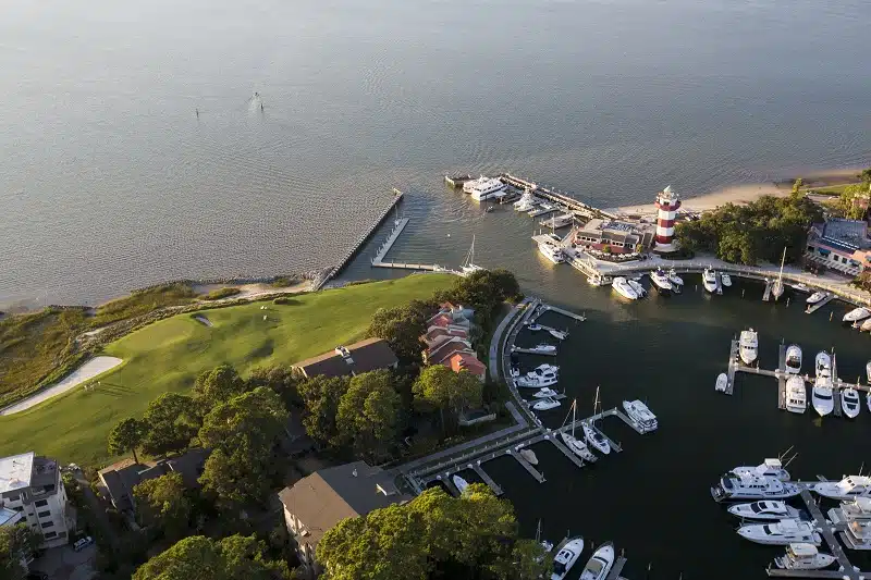
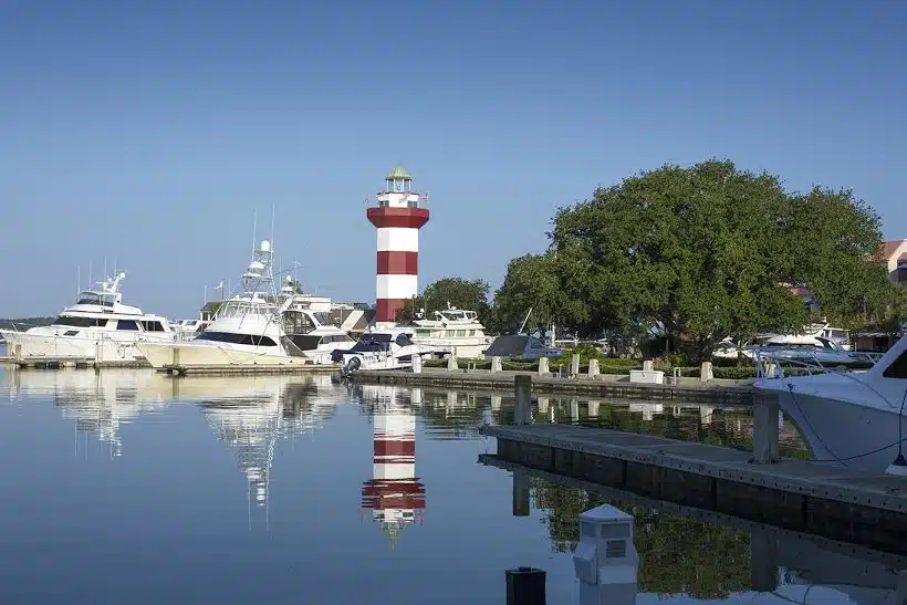
      CHARLESTON, SOUTH CAROLINA (July 6, 2016) – For the first time, readers of Travel + Leisure magazine have voted Charleston, South Carolina the World’s Best City in the 2016 World’s Best Awards. Charleston is the first domestic destination to earn the coveted World’s Best City ranking, and for the fourth consecutive year, the readers of Travel + Leisure ranked the Charleston area the No. 1 City in the U.S. and Canada. The news was shared by Jacqui Gifford, Senior Editor of Travel + Leisure, on the TODAY Show on July 6.

      Charleston exceeded other destinations in the categories of sights/landmarks, culture/arts, restaurants/food, people/friendliness, shopping and value to earn the World’s Best City and the No. 1 City in the U.S. and Canada designation, scoring 91.66 overall. The complete results of the 2016 World’s Best Awards Survey are featured on TravelandLeisure.com/WorldsBest and in the August issue of the magazine, on newsstands July 15.

      Travel + Leisure Editor Nathan Lump said, “Charleston is a remarkably dynamic place, so it’s no surprise that it has achieved its highest ranking ever in our survey as this year’s best city in the world. The city has managed to preserve all the qualities for which it is widely known—a prime coastal setting, historic architecture, friendly locals—while also nurturing a creative culture that is making it one of the most notable destinations for those who seek out interesting restaurants, bars, and shops that highlight a dedication to distinctive craft.”

      The No. 1 rankings continue to positively impact tourism, the number one economic driver to the Charleston area. Since 2012, the first year Charleston was awarded the No. 1 City in the U.S. and Canada ranking in the Travel + LeisureWorld’s Best Awards, the total economic impact of tourism has increased 14% to $3.68 billion in 2015 according the Office of Tourism Analysis at the College of Charleston. Additionally, the average expenditure per adult and the total labor earnings has increased.

      Dan Blumenstock, Chairman of the Charleston Area Convention & Visitors Bureau and Director of Hotel Operations of Fennell Holdings remarked, “Readers of Travel + Leisure continue to recognize our destination for its friendly people, renowned cuisine, historic landmarks, flourishing arts community, and celebrated shopping scene. This award is a testament to the vitality of Charleston as a world class destination.” Blumenstock added, “The area’s tourism and hospitality community has enjoyed positive growth over the past four years, due in part to the numerous awards bestowed on the Charleston area. We look forward to continued and responsible economic impact as a result of the No. 1 City in the World ranking.”

      In addition to the No. 1 City rankings, The Spectator Hotel, located in historic Charleston, was recognized as the No. 1 Top City Hotel in the U.S.

      Michael Tall, President & Chief Operating Officer of Charlestowne Hotels stated, “The Spectator was designed, and is operated, with our discerning guests’ needs and desires for a unique, curated experience. With the hotel only having opened less than a year ago, we are truly honored to be recognized by the readers of Travel + Leisure as the No. 1 Top City Hotel in the 2016 World’s Best Awards in the categories of rooms and facilities, service, location, value, and design.”  

      Travel + Leisure readers voted on their favorite hotels, cities, islands, spas, cruise lines, airlines, tour outfitters, and car-rental agencies. The 2016 World’s Best Awards readers’ survey results (listed by overall and regional rankings) and survey methodology are featured in the August issue of Travel + Leisure magazine, online at: www.TravelandLeisure.com/WorldsBest, and in the World’s Best Awards 2016.

      Click Here To View the South Carolina Cruisers’ Net Marina Directory Listing For Charleston City Marina

      Click Here To Open A Chart View Window, Zoomed To the Location of Charleston City Marina

      Click Here To View the South Carolina Cruisers’ Net Marina Directory Listing For Charleston Harbor Marina

      Click Here To Open A Chart View Window, Zoomed To the Location of Charleston Harbor Marina

      Be the first to comment!

    • Captain Jim Healy Discusses the Waterway from Charleston to St. Augustine

      Longtime cruiser and SSECN Contributing Editor, Captain Jim Healy, shares his knowledge and experience in these observations on this portion of the Atlantic Intracoastal Waterway. Thank you Jim!

      The entire region from Charleston to St. Augustine has high tidal ranges, ranging from 5′ at St. Augustine to as much as 9′ in Savannah/Beaufort/Charleston.  Those high tidal ranges create swift tidal currents, and especially for first-times, docking is easiest in the 1/2 hour before and after slack.
      There are many areas of shallow water in the region.  The very best resource for current data on low water and caution areas is available via www.activecaptain.com.  Two other  websites that all ICW travelers should know about are www.waterwayguide.com and www.cruisersnet.net.  I’m sure you are familiar with the Waterway Guide book series.  The “Salty Southeast Cruiser’s Net” (SSECN) is  really a boating group.  It was founded by Claiborne Young.  After Claiborne’s untimely loss, the group continued in operation.  The Cruiser’s Net website specializes on the US Southeast.  There is some duplication of material between the WWG site and the SSECN site, but there is unique value to both.  Both are excellent resources for fuel prices, marinas and anchorages.  These websites would make a good sidebar for any ICW article.  Two of these websites require registration – SSECN does not – and all three are free, and all are very useful to ICW boaters.  Both WWG and SSECN also have smart phone apps that duplicate and augment website information and are very useful on small-format devices.
      There are some generalizations that apply to the region, including the stretch from Georgetown, SC all the way south to below Fernandina Beach.  In some of those areas, boats drawing more than 4′ will want to consider not traveling at low tide; especially celestial low tides.  The Army Corp of Engineers (USACE) is responsible for dredging the ICW.  USACE is funded by state congressional delegations.  In recent years, the money congress allocates to dredging has been diverted to “more pressing needs,” and so many areas of the ICW are shoaling, and in fact, the ICW resource is slowly being lost; well, allowed to die, really, by congress.  There is a not-for-profit called the Atlantic Intracoastal Waterway Association.  The Executive Director is Brad Pickel; bpickel@seahavenconsulting.com.  That would make another sidebar for any article on the ICW.  There are some local knowledge bypasses around some shoal areas.  All of the cruising sites above can provide additional detail.
      Renting a car in any of these venues greatly expands what a boating visitor can see and do.  Some, but not all, marinas have courtesy cars.  Generally they can’t be used for long periods, but they are useful for re-provisioning when needed.
      Hope this helps.
      Jim
      Peg and Jim Healy aboard Sanctuary, currently at Ft. Myers, FL

      Be the first to comment!

    • A Good Visit to Shelter Cove Marina, Hilton Head, SC, AICW Statute Mile 564


      Shelter Cove is located in a man-made cove on the southeastern shores of Broad Creek in Hilton Head Island near creek markers #22 and #23. Broad Creek departs the Waterway on the eastern shore of Calibogue Sound just as the Waterway turns west into the Copper River. Our thanks to Dick Lawson for this review.

      Spent 4 nights here this past month. This is a beautiful and very well run marina. It is large and slips can be either close to the “action” or close to the marina office/store and showers. Regardless, one of the dock boys will show up in a golf cart to deliver you to your destination. Within walking distance there are several very nice restaurants and other shops. Transportation is also provided to the supermarket, or to the beach. Location is several miles off the ICW, up Broad Creek, and, as the name implies, it is very sheltered. Look forward to a return trip.
      Dick Lawson

      Click Here To View the South Carolina Cruisers’ Net Marina Directory Listing For Shelter Cove Marina

      Click Here To Open A Chart View Window, Zoomed To the Location of Shelter Cove Marina

      Be the first to comment!

    • Captain Jim Healy on Charleston and Beaufort, SC and Savannah, GA

      Contributing Editor, Captain Jim Healy, shares his perspective on Charleston and Beaufort, SC and Savannah, GA where several SALTY SOUTHEAST CRUISERS’ NET SPONSORs are located. Thank you Jim!

      Charleston_city_marina_130x130_2

      Charleston, SC and Savannah, GA: magnificent old southern cities with many points-of- charleston-harbor interest and fine restaurants; our strategy is to take a tour bus around the city.  Look for a tour company that has same-day on-and-off privileges.  (We do this every time we arrive somewhere we’ve not been before, including Canada).  We take the entire tour circuit first, then go back to places that we think we’d like to know more about.  At Charleston, start at the Welcome Center.  Or, take the tour boat to Fort Sumter; nice stjohns aquarium near the Ft. Sumter ferry docks.  In Charleston, there is a water taxi from the Charleston Maritime Center that goes back and forth to Patriot Point, which is savanahhyattdocks where the USS Yorktown is located.  In Savannah, there is a nice stage theater within walking distance of the downtown waterfront (http://www.savannahtheatre.com).  The Savannah waterfront is very interesting, with a large riverwalk, wonderful park overlooking the River, and large shipping and commercial traffic as well as every kind of small-isleofhopeboat and pleasure craft.  There are several architecture tours in both cities, and both have lots of weekly and seasonal activity for visitors.  From Savannah (there are marina options in downtown Savannah on the Savannah River or at Thunderbolt and Isle of Hope), boaters can also visit Tybee Island (light house and Fort Pulaski).

      beaufort-sc-marina

      Beaufort, SC: from the Beaufort Downtown Marina, take a carriage tour through the historic ante-bellum homes in the area.  The downtown is friendly with many shoppes and good restaurant options.

      Jim Healy

      Be the first to comment!

    • Report from Hague Marina, Myrtle Beach, SC, AICW Statute Mile 368.5


      Hague Marina is located in a sheltered loop on the Waterway’s southern shore some 2.4 nautical miles southwest of the Myrtle Beach high-rise and railroad bridge.

      They had a fantastic ships store but it burned. Owner is making do right now with small office building.
      Fabrication shop and tools were not damaged in fire, so they can still do anything you need. Not fancy, but gets job done. My brother worked there from 1972-2013. He quit to be a Restaurant Chef.
      Frederick

      Click Here To View the Cruisers’ Net’s South Carolina Marina Directory Listing For Hague Marina

      Click Here To Open A Chart View Window, Zoomed To the Location of Hague Marina

      Comments from Cruisers (2)

      1. Capt. Don -  June 3, 2016 - 9:05 pm

        The Hague is a dump. Don’t get on the docks or you risk injury. Avoid at all cost. Unreliable power and water you shouldn’t drink. The owner is not concerned about “customer service” and is only interested in an offer for the property. The previous poster obviously had a misplaced loyalty to the owner…

        Reply to Capt.
        • Melissa -  May 15, 2018 - 1:24 pm

          Could you please respond in more detail about your experience with Hague Marina, and especially why you say, “don’t drink the water.”

          Reply to Melissa
    • Little River Swing Bridge Stuck in Open Position, AICW Statute Mile 347


      harbourgatemarina

      Bad news for motorists, good news for boaters – at least until inevitable repairs begin. With a closed vertical clearance of 7ft, Little River Swing Bridge crosses the ICW just south of SALTY SOUTHEAST CRUISERS’ NET SPONSOR Harbougate Marina. This Associate Press report comes from The Daily Reporter, Greenfield, Indiana (!!).

      A swinging bridge over the Intracoastal Waterway near North Myrtle Beach has been closed after the gearbox that moves the bridge broke.
      THE ASSOCIATED PRESS
      First Posted: June 02, 2016 – 5:48 pm
      Last Updated: June 02, 2016 – 5:48 pm

      CLICK HERE for the full report.

      Click Here To View the Eastern Florida Cruisers’ Net Anchorage Directory Listing For Little River Swing Bridge

      Click Here To Open A Chart View Window, Zoomed To the Location of Little River Swing Bridge

      Click Here To View the Cruisers’ Net’s South Carolina Marina Directory Listing For Harbourgate Marina

      Click Here To Open A Chart View Window, Zoomed To the Location of Harbourgate Marina

      Be the first to comment!

    • Good Words for Little River Swing Bridge Tender, AICW Statute Mile 347


      A Marina That's As Luxurious As It Is Convenient Close to Myrtle Beach with clear sailing to the Atlantic. The Harbourgate Marina Village is your gateway in North Myrtle Beach to all the excitement a
      We most often receive complaints about bridge tenders, so it’s nice to hear good words for an oft maligned bridge. With a closed vertical clearance of 7ft, Little River Swing Bridge crosses the Waterway at Statute Mile 347 just south of SALTY SOUTHEAST CRUISERS’ NET SPONSOR, Harbourgate Marina.

      Very attentive and efficient bridge tender.
      Traveling under 5/23/16 mid day.
      Carolyn Hackett

      Click Here To View the South Carolina Cruisers’ Net Bridge Directory Listing For Little River Swing Bridge

      Click Here To Open A Chart View Window, Zoomed To the Location of Little River Swing Bridge

      Click Here To View the Cruisers’ Net’s South Carolina Marina Directory Listing For Harbourgate Marina

      Click Here To Open A Chart View Window, Zoomed To the Location of Harbourgate Marina

      Comments from Cruisers (3)

      1. David Boxmeyer -  May 28, 2016 - 3:41 pm

        I agree this is one of the easiest bridges on the ICW to get through. The Alligator River Bridge is another one who has their act together.

        Reply to David
      2. Capt. Don -  May 27, 2016 - 2:09 pm

        I’ll second that. Just a couple of years ago the comments were negative. Now, however, the bridge tenders are very courteous and attentive. It’s been a welcomed change…kudos to them!

        Reply to Capt.
      3. John Winter -  May 27, 2016 - 1:45 pm

        Yep, he is a good one. This is our home port, so we travel under this bridge a lot. He will accommodate boaters nicely

        Reply to John
    • Ridley Report: Bull Creek Anchorage, AICW Statute Mile 565.5


      Charlie and Jackie continue their journey north with a report on these two anchorages, southern and northern upstream, on the waters of Bull Creek, south of Calibogue Sound and Hilton Head Island, east of the Waterway’s flashing daybeacon #34.

      5-2-16 Now anchored in one of our favorites– Bull Crk east off ICW just south of MM565. Anchored in front of house where water not so deep. Good holding and usual tidal current. Good verizon. Look out over Calibogue Sound and Hilton Head island. Nice.
      Charlie and Jackie on Traveler

      Click Here To View the Cruisers’ Net’s South Carolina Anchorage Directory Listing For Bull Creek Anchorages

      Click Here To Open A Chart View Window, Zoomed To the Location of Bull Creek

      Be the first to comment!

    • Ridley Report from Tom Point Anchorage, AICW Statute Mile 495.5


      Skippers Charlie and Jackie Ridley have submitted several reports documenting their voyage north on the Waterway, beginning with Tom Point Creek anchorage, one of the best south of Charleston, as a number of you have commented.

      5-1-16 Anchored in Tom Point Creek just past MM 495. Easy in and out. In about 8′, good holding and plenty room for other boats, but were none. 3-4 bars on Verizon–great views!! Tide current usual.
      Charlie and Jackie on Traveler.

      5-14-16 Anchored in Big Tom Creek about ½ mile in from MM613, Wide channel and easy in and out of creek. Anchor set first try. Decent Verizon. Beautiful sunset!! will stop here again.
      Charlie and Jackie on Traveler.

      Click Here To View the Cruisers’ Net’s South Carolina Anchorage Directory Listing For Tom Point Creek Anchorages

      Click Here To Open A Chart View Window, Zoomed To the Location of Tom Point Creek

      Be the first to comment!

    • FOCUS ON Harbour Town Yacht Basin, Hilton Head Island, SC, AICW Statute Mile 565


      Harbour Town at Hilton Head, with its familiar red-and-white-striped lighthouse, is a fine resort marina with an enormous number of amenities.

      Harbor Town Yacht Basin, A SALTY SOUTHEAST CRUISERS’ NET SPONSOR, lies just off the Atlantic Intracoastal Waterway on Calibogue Sound, below Statute Mile 565 at Marker 32, right in the heart of The Sea Pines Resort.

      Recently voted the 2015 “Marina of the Year” by Marina Dock Age magazine, the Harbour Town Yacht Basin has been a place for visitors and guests to enjoy world-class accommodations for over 40 years. Located in the heart of The Sea Pines Resort and on the Calibogue Sound, this full-service marina offers everything: shopping, dining, entertainment, watersports, fishing charters, cruises, and much more. Irrefutably Hilton Head Island’s most famous and visited marina, our amiable and experienced staff and Harbourmaster are dedicated to providing each visitor and guest with lifelong memories all amidst the spectacular backdrop of the iconic Harbour Town Lighthouse.
      C30A8407 (1)
      The Harbour Town Yacht Basin was built in 1969 by legendary founder, Charles Fraser. Modeled after a famous harbor in Portofino, Italy, Harbour Town Yacht Basin was designed to attract visitors while preserving the natural beauty of the landscape. This included preserving the Liberty Oak, which was incorporated into the layout of the marina in lieu of building more slips. Centuries old, the Liberty Oak has stood as a symbolic landmark for wedding venues and concerts, but the most iconic image of the yacht basin is the Harbour Town Lighthouse. Constructed the same year as the marina, the lighthouse has welcomed visitors to one of the most beautiful and unique places on earth while offering one-of-a-kind views.
      tower
      Harbour Town Yacht Basin is an intimate marina that offers over 100 docking slips where visitors can dock nightly, monthly, or even for a lifetime. Modern facilities and exceptional service continue to contribute to the world-class resort experience that keeps guests coming back year after year. Guests and visitors at the yacht basin can enjoy world-class facilities throughout The Sea Pines Resort, such as the Harbour Town Clubhouse, the Sea Pines Beach Club, the Plantation Golf Club, and the luxurious Inn & Club at Harbour Town.
      rockers
      Guests can enjoy charter fishing, cruises and sightseeing tours, as well as watersports at Harbour Town. Explore fertile fishing grounds with the island’s most experienced captains on a three-hour or overnight excursion aboard a fishing charter, observe various marine life from aboard a multi-passenger yacht during a sightseeing tour of Calibogue Sound and Daufuskie Island, or close up on a waverunner, kayak, or paddleboard.

      Click Here To View the Eastern Florida Cruisers’ Net Marina Directory Listing For Harbor Town Yacht Basin

      Click Here To Open A Chart View Window, Zoomed To the Location of Harbor Town Yacht Basin

      Be the first to comment!


    Social Media Auto Publish Powered By : XYZScripts.com