All Charleston County Park & Recreation Commission parks and facilities will close at 3 p.m. today and remain closed on Tuesday, August 6 and Wednesday, August 7.
All Charleston County Parks programs and camps have been canceled through Thursday, August 8.
Here’s your perfect excuse to cut out early and head to our parks — June is National Great Outdoors Month! Fly a kite in the meadow, build a sandcastle on the beach, hike a trail, go fishin’ from the pier, watch for birds on the marsh boardwalk, or splash around the waterpark!
Cool ‘n’ Fit
When you need to hit the gym but really want to go to the pool, dive into our aquatic fitness classes for the best of both! Enjoy a wellness-boosting workout in the water when you register for the July session of H2O Moves 4.5 or H2O Balance & Flexibility.
#LifeguardGoals
Give your young swimmer a sneak peek at lifeguarding in our Junior Lifeguard Program. Kids will get hands-on experience in first aid, training, environmental awareness, rescue equipment and more. Spots are filling quickly, so nab yours today!
Your Holidays Start Here
Escape for a cozy holiday weekend – right in our backyard. Enter to win a magical 2-night stay at a cottage in James Island County Park on the opening weekend of the 2024 Holiday Festival of Lights. The winner will be drawn on June 20.
Go Skate Day
This Friday, grab your board and head to SK8 Charleston for a local celebration of international Go Skate Day. Newbies are welcome, and more experienced skaters can show off their skills – and win sweet swag – in our Mini-Quarter and Euro Gap contests.
PaddleSUP
Ease back on the throttle this summer when you sign up for our paddlesport essentials classes. Cruising local waterways in a kayak or on a SUP offers a fresh, relaxing perspective on coastal living. Plus our instructors have that whole “fun teacher” thing going for them, so it’s a whole chill vibe.
This is one of 161 derelict boats that the non-profit Wounded Nature-Working Veterans has helped remove from South Carolina waters. The group’s leader thinks a new kind of insurance would solve the problem.
Wounded Nature-Working Veterans is a group of veterans, non-veterans and active duty military personnel run locally by Captain Rudy Socha, a former Marine turned conservationist. The non-profit volunteer organization is working to cleanup, preserve and protect our coastal environment, particularly from derelict vessels.
Spice up your Spring! The Lowcountry Cajun Festival is bringing Louisiana to the Lowcountry with a full day of Zydeco music, Cajun and Creole foods, kids activities, and all-around ragin’ Cajun fun!
Moonlight Mixers are back at the Folly Beach Pier!
Enjoy 5 nights of dancing and music this summer
[FOLLY BEACH] – The Moonlight Mixer series on the Folly Beach Pier is back once again! The pier’s Mixers series will kick off on Friday, May 3.
All ages are invited to celebrate summertime with some dancing on the Folly Beach Pier. On five Friday evenings this summer, dancers will enjoy music from a DJ or live band. On May 3, July 26 and Sept. 20, DJ Bill Shelton will spin the hottest oldies and beach music. And on June 14 and Aug. 16, the Dave Landeo Trio will perform a variety of upbeat, energetic covers and originals.
Advance tickets are $10 per person. If the event has not sold out, on-site tickets will be $15 per person. Tickets are limited and the events are expected to sell out, so advance purchase is recommended. Event hours are 7 – 10 p.m.
Beverages will be available for purchase on site. No outside food or drink is allowed, and pets are not permitted at the event. Food and snacks will be available for purchase at the Pier 101 Restaurant and the Gangplank Gift & Tackle Shop, both located at the entrance to the pier. Food, beverages and parking fees are not included with ticket purchase. Chairs are welcome as seating is limited.
The Folly Beach Pier opened to the public on Dec. 26, 2022. The 1049-foot-long pier is 25 feet wide and features concrete pilings and substructure, with a wooden walkway and railings. Amenities at the Folly Beach Pier include restrooms, the Pier 101 Restaurant and Bar, beach access, showers, and the Gangplank Gift & Tackle Shop (which sells gifts, sundry items, refreshments and tackle/bait, and offers rod rentals). The iconic Folly Beach Pier is the perfect location for saltwater fishing, walking, birding and breathtaking views of the Atlantic Ocean and the “Edge of America.”
Moonlight Mixers offer accessible parking, restrooms, and water fountains, as well as an accessible ramp to the pier and an accessible route to the event area at the end of the pier. KultureCity Sensory Bags are available for checkout on a first-come, first-served basis during the event. Visit the event gate for more information on accessibility in your parks. For additional information on the Folly Beach Pier, visit ccprc.com/follypier.
For details or to purchase tickets, call 843-795-4386 or visit CharlestonCountyParks.com (direct link). This event is brought to you by Dasani and your Charleston County Parks.
Owned and operated by the Charleston County Park & Recreation Commission (CCPRC), the Folly Beach Fishing Pier is located at 101 East Arctic Avenue on Folly Beach. The mission of CCPRC is to improve the quality of life in Charleston County by offering a diverse system of park facilities, programs and services. The large park system features over 11,000 acres of property and includes six regional parks, three beach parks, three dog parks, two landmark fishing piers, a skate park, three waterparks, a historic plantation site, 19 boat landings, a climbing wall, a challenge course, an interpretive center, an equestrian center, cottages, a campground, a marina, as well as wedding, meeting and event facilities.The park system also offers a wide variety of recreational services – festivals, camps, classes, programs, volunteer opportunities, and more. For more information, call 843-795-4386, or visit www.charlestoncountyparks.com.
Photos courtesy Charleston County Parks. High resolution photos available upon request
Wounded Nature-Working Veterans is a group of veterans, non-veterans and active duty military personnel run locally by Captain Rudy Socha, a former Marine turned conservationist. The non-profit volunteer organization is working to cleanup, preserve and protect our coastal environment, particularly from derelict vessels.
Charleston Harbor Resort and Marina, A CRUISERS NET SPONSOR, sits on the Mount Pleasant side of Charleston Harbor, hard by Patriots Point between Horse Reach’s flashing buoys #34 and #36.
Join us for Oysters on the Point in 2024 with Thomas Champagne & Friends!
Wounded Nature-Working Veterans is a group of veterans, non-veterans and active duty military personnel run locally by Captain Rudy Socha, a former Marine turned conservationist. The non-profit volunteer organization is working to cleanup, preserve and protect our coastal environment, particularly from derelict vessels.
Harbour Town Yacht Basin, A CRUISERS NET SPONSOR, is ready for your reservation with newly renovated docks, upgraded electrical service and onSpot WiFi, also a CRUISERS NET SPONSOR. And, as always, numerous year round activities at the Sea Pines Resort are offered for your enjoyment. Hilton Head Island is absolutely marvelous any time of year.
Harbour Town Yacht Basin Earns Prestigious South Carolina
Clean Marina Program Certification
HILTON HEAD ISLAND, S.C. (November 9, 2023) – Harbour Town Yacht Basin has been awarded South Carolina Clean Marina Program certification, recognizing its commitment to preserving the environment and enhancing the water quality for recreational boaters throughout the state of South Carolina. This voluntary certification program is a testament to Harbour Town Yacht Basin’s dedication to implementing best management practices that reduce pollution and protect the marine environment.
“Harbour Town Yacht Basin is honored to be acknowledged by the South Carolina Clean Marina Program for our commitment to preserving our beautiful coastal environment,” said Rob Bender, Director of Recreation and Marine Operations. “This certification demonstrates our ongoing dedication to environmentally responsible practices and creating a safe and enjoyable experience for boaters.”
The Clean Marina designation is awarded to marinas that exhibit outstanding characteristics, including design considerations, effective marina management, emergency planning, fuel control, proper sewage and waste disposal, stormwater control, habitat protection, and boater education. Beyond the environmental benefits, these practices also lead to reduced waste disposal costs, attract responsible boaters, and open potential new sources of revenue for certified marinas.
Harbour Town Yacht Basin is part of the national Clean Marina Program, which consists of 38 state programs, united under the common goal of promoting environmentally responsible working and maintenance procedures in marinas. This voluntary program encourages marina operators to collaborate with regulatory agencies and the boating community to ensure sustainable practices.
For more information about Sea Pines Resort and Harbour Town Yacht Basin, visit www.seapines.com.
About The Sea Pines Resort
Situated on the southernmost tip of Hilton Head Island, the legendary Lowcountry destination features five miles of unspoiled beaches, 20 clay tennis courts, 14 miles of bike and walking trails, horseback riding, Eco-Adventures, water sports, and the 605-acre Sea Pines Forest Preserve filled with wildflowers, wetlands, and more than 130 species of birds. As the first eco-planned destination in the U.S., The Sea Pines Resort has become the blueprint for numerous beach developments around the country. Guests can choose from an array of accommodations, including 300 villas, 100 rental homes, and the luxurious 60-room Inn & Club at Harbour Town, a Forbes Four-Star boutique hotel and Preferred Hotel Group member. The resort’s best-in-class collection of golf courses, amenities, meeting facilities, and accommodations makes Sea Pines one of the most sought-after leisure and group destinations in America.
Harborwalk Marina, A CRUISERS NET SPONSORS, is only a boardwalk stroll away from Georgetown’s Historic District for history, entertainment, great food and shopping. Harborwalk Marina is the third marina on your starboard side as you enter the protected waters of Georgetown.
Palmetto Park Jam is your ticket to an afternoon of rhythm, soul, and unforgettable memories by the marsh at Palmetto Islands County Park this Sunday, October 15th! Immerse yourself in the legendary sounds of the Allman Brothers while discovering unique crafts from local vendors along with food and drinks. Gold Pass members get in free!
Harvest Festival
Clear your calendar for a bumper crop of fall fun! On November 4, our annual Harvest Festival will serve up a foot-stompin’, finger-licking, pumpkin-decorating, hayride-taking, kid-crafting afternoon that’s perfect for the entire family.
Be a Magic Maker!
Are you ready to sprinkle some extra holiday cheer this season?Join our team at the Holiday Festival of Lights. You can be a seasonal force behind a jolly good time for thousands of festival-goers! Come be a part of something tree-mendous.
Monarch Migration
Did you know? South Carolina is on the flight path for the annual monarch butterfly migration! On October 20, join a naturalist to learn more about these winged wonders, their extraordinary journey, and how you can play a part in important monarch tag and release research.
Last call!
Time to reel it in: October 21 marks the final Cast Off Fishing Tournament of 2023…and your last chance to catch the Big One! Grab your rod and tackle and head to the Mount Pleasant Pier to drop a line and claim your prize.
Tickets, please
You say: It’s not even Halloween! We say: It’s never too early to plan your visit to the Holiday Festival of Lights! Tickets for this year’s event are now available on our website, so you and your merry band of revelers can begin planning your annual evening under the lights!
Heads Up!
Palmetto Islands County Park will be closed until 4:30 p.m. on Sunday, October 15 so that we may host the Palmetto Park Jam. For ticketed guests, the park gates open at 11 a.m.
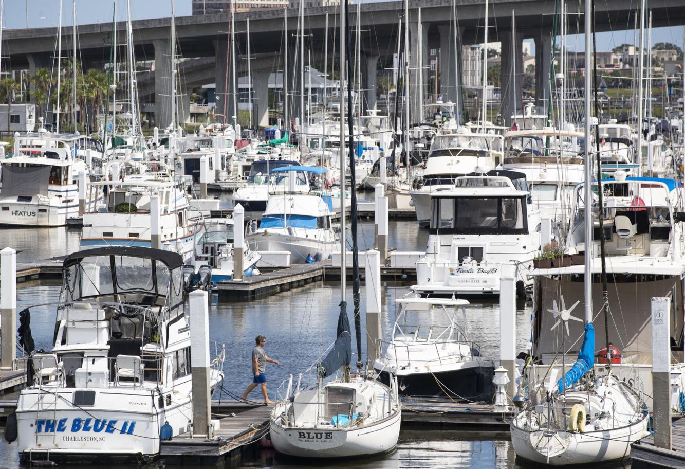
Slip rentals in the Lowcountry are expensive, ranging between about $500 and $1,000 a month for people with boats up to 45 feet long. Transient slips are even more.
A man walks down the dock at the Harborage at Ashley Marina in Charleston on Sept. 10, 2023. Henry Taylor/Staff By Henry Taylor htaylor@postandcourier.com
Many boat owners in the Charleston area have a love/hate relationship with their marinas. Mostly they love the access to year-round wet slips, fuel docks, pump-outs, dock hands, marina toilets, fish cleaning stations and a degree of security.
They hate it when the bill arrives, though.
Slip rentals in the Lowcountry are expensive, ranging between about $500 and $1,000 a month for people with boats up to 45 feet long. (The biggest motor and sailing yachts can pay much more than that, and transient boats pay a premium rate per foot for access to outside docks.)
Perhaps you’ve noticed that the marinas in the area are full, or nearly so. A few of them are expanding. The opportunities are ripe, and some with deep pockets are investing in Charleston’s marine sector, joining a broader consolidation trend.
A sign in reference to dock expansions underway at the Safe Harbor Charleston City Marina on Sept. 10, 2023. Henry Taylor/Staff
By Henry Taylor htaylor@postandcourier.com
The supply clearly is not keeping up with the demand. Part of the reason is population growth. As the region welcomes more residents, some with plenty of disposable income, the number of boats increases, too. Another part of the reason is that waters in the Charleston area are particularly inviting to boaters.
“Boating here is still fantastic on Charleston Harbor,” noted Chuck Laughlin, president of St. Bart’s Yachts, a Beneteau dealer based at the City Marina on the Ashley River. “On any given day you can be one of a few boats out there. It’s still not crowded like Lake Norman outside of Charlotte, where you feel you’re taking your life in your hands.”
And, he said, boaters here can visit nearby destinations: Hilton Head Island, Georgetown, Little River. They can venture south to Florida. They can plan short crossings to the Bahamas, which is relatively easy to reach.
And if they are sailboat operators, they can race. The Charleston Ocean Racing Association has registered 30 boats for its annual October “Alice Cup” race between the harbor and Rockville. That’s a big number, much more than in recent years, and it suggests a surging interest in offshore sailing, said Ray Spellerberg, co-owner of the sailboat Celedon. It wasn’t long ago that CORA struggled to generate interest in its offshore races, Spellerberg said.
All these boats — those regularly used and those merely left to languish by absentee owners — need to rest somewhere. The area has 11 marinas with wet slips. Not all accommodate sailboats. All of them house a number of boats that rarely get taken out.
“It just breaks my heart,” said Rand Pratt, director of operations for Charleston Harbor Marina.
The least expensive is the Cooper River Marina, operated by the Charleston County Parks. The owner of a 30-foot boat who keeps the vessel there long-term will pay a little more than $500 a month.
A dog walker on the docks of the Safe Harbor Charleston City Marina on Sept. 10, 2023. Henry Taylor/Staff
By Henry Taylor htaylor@postandcourier.com
Spellerberg keeps his boat at Hobcaw Creek Community Docks which, with just 18 slips, is perhaps the smallest marina in the area. If you define “marina” as a place that includes not just slips but services, too, then maybe Hobcaw would not qualify. All it provides is a power pedestal so boats can charge their batteries while at rest.
“We like where we’re at,” Spellerberg said. He and his co-owner live nearby. “We’re grateful we don’t have to go into a larger marina setting. It can get cost prohibitive.”
He pointed out that marina costs represent only a portion of money boat owners spend each year. Merely keeping a boat in good working order requires significant investment.
And that presents another challenge: More boats mean more boat repairs and maintenance, which mean longer wait times at the boatyards. It can take months to get even a small job scheduled, Spellerberg observed. The high demand for space and services is driving costs up, he said.
The marina operators know the power they wield. And they recognize an opportunity when they see one. In recent years, Safe Harbor Marinas has purchased the City Marina, the Bristol Marina nearby and the City Boatyard on the Wando River. The Dallas-based company also owns marinas in Beaufort, Hilton Head, Port Royal (two) and Pawley’s Island. Overall, it owns 130 marinas, boatyards and other facilities, located in 24 states and Puerto Rico.
Charleston area marinas try to catch up with demand as more and more boaters use local waterways. (Source: Esri)Brandon Lockett/Staf
Safe Harbor was purchased by Sun Communities in 2020 for $2 billion.
The City Marina is located on public land, owned by the city of Charleston, and leased to Safe Harbor. And guess what? It’s expanding.
Famous for its Megadock, where the mega yachts tie down when in town, the City Marina is adding dockage space that extends toward the middle of the Ashley River.
“We have almost completed the north Megadock,” General Manager David Isom said. “After that, we will start to attach these 100-foot-long concrete finger piers, then start rebuilding the north basin of the marina.”
Some old concrete walls, remnants of the original marina design that can disrupt the current flow, soon will be removed, he added. That will make it easier and safer to tie up to the new floating docks, which don’t hinder the current, and perhaps help minimize silting.
The new slips are meant for longer and wider boats, Isom said.
A worker walks along a dock addition at Seabreeze Marina in Charleston on Sept. 11, 2023. Henry Taylor/Staff
By Henry Taylor htaylor@postandcourier.com
When all is said and done, the City Marina will be among the largest in the country. Add up the space on both sides of the new Megadock and you get the equivalent of one mile of linear dockage, he said.
Other marinas are getting bigger, too.
Seabreeze, located on the Charleston peninsula in the shadow of the Ravenel Bridge, just added dozens of powerboat slips. And Shuler now is hoping to build a yacht club on that end of Johns Island, near Bohicket Marina.
Charleston Harbor Marina, too, is planning an expansion that will add dozens of slips on the south side of the site, according to Pratt. It’s already installed new breakwaters that are wider, deeper and offer better protection from westerly weather.
“We’re primarily trying to protect our investment,” he said. Though the added revenue certainly is another reason.
The future could see more linear dockage on the north side of the marina, meant to accommodate a growing number of catamarans, Pratt said. Plus College of Charleston Sailing, which is based in the marina, is looking to grow, he said.
An intense sunset viewed from Charleston Harbor Marina earlier this year. Adam Parker/Staff
Adam Parker aparker@postandcourier.com
Demand is high for space, and the marina maintains a wait list, though the wait period isn’t crazy yet, Pratt said.
A big challenge is updating the marina to keep pace with changes in boating behavior and design. Boats are bigger now. A marina designed 35 years ago might not be sufficiently equipped to accommodate all of today’s boaters.
Not all marinas are built alike. Most rely on long wooden pilings along which the docks float up and down according to the tides. At City Marina, the water must rise 17 feet before the docks slip off the top of the pilings and float away.
A view from Charleston Harbor Marina at sunset on a calm evening. Adam Parker/Staff
Adam Parker aparker@postandcourier.com
Charleston Harbor Marina instead relies on a Swedish design developed to manage the big tidal swings of the North Sea. The docks are held in place not by pilings but by crisscrossed chains anchored to the harbor floor. The marina’s only pilings are support structures for powerboat lifts. Some were recently added to bring the total number of mechanical lifts to 42.
Needless to say, upgrades are expensive. So is regular maintenance, especially in an area with a soft bottom that sometimes needs dredging and the annual threat of tropical storms. Pratt wouldn’t name a figure saying only that his annual operating costs were “astronomical.”
It doesn’t cost that much to maintain a mooring field. There’s a new one in the Wando River, 1 River Landing, near the Daniel Island Yacht Club. For a 30-foot boat, you pay $275 a week, $475 a month or $4,320 a year. (Bigger boats pay more.)
A lot of boats
Laughlin said business is good. The demand for his Beneteau sailboats and powerboats remains pretty high. There was an uptick in sales during the pandemic, despite a manufacturing shortage because of COVID’s impacts on factories trying to keep their employees safe.
When he started out 36 years ago, a big Beneteau cost perhaps $150,000, he said. Today it’s approaching $7 million.
It’s worth noting that many boat companies have manufacturing operations here in South Carolina. The state Department of Commerce recognizes 28 boat makers headquartered here, including a few big ones: Scout, Sportsman and Key West. (Beneteau had a factory in Marion, but closed it in 2020. The facility was purchased by a Canadian swimming pool company which, like boat manufacturers, molds fiberglass.)
A small boat drives past others docked in their slips on the Ashley River in Charleston on Sept. 10, 2023. Henry Taylor/Staff
By Henry Taylor htaylor@postandcourier.com
As of the beginning of 2023, the total number of registered recreational boats in South Carolina was about 360,000, according to the Department of Natural Resources. A little more than 317,000 are powerboats; 2,000 are sailboats.
Many powerboats are kept in dry stack marinas, of which there are several in the area. Perhaps the majority of powerboats are trailered and kept in driveways. Owners ease them in and out of the water at designated boat ramps.
Boats can be seen through a decorative gate at the Safe Harbor Charleston City Marina on Sept. 10, 2023. Henry Taylor/Staff
By Henry Taylor htaylor@postandcourier.com
A recent trend affords recreational boaters the chance to get on the water without owning a vessel. Boat clubs are on the rise. Pay a membership fee and get access to a fleet of small powerboats. The City Marina is home to two such clubs. Seabreeze has one, too. Fortunately for them, the powerboat market is strong. The pandemic inspired some people to invest in new boats. Now that the worst of COVID is past and the market is leveling off again, there’s some excess inventory, noted Isom. What will happen to those vessels?
“The boat clubs are going to start buying them up,” he said.
Which means we’ll see even more people on the water, many with little boating experience. And that means an increase in the “danger level,” as Spellerberg has warned.
South Carolina is currently one of only four US states with no boater education requirements. The new bill will add South Carolina to the majority of states that require boating safety courses for some or all boaters.
As the article points out, South Carolina is one of only 4 states that did not have a similar training requirement. Whether the boater training is actually adequate or not is open for discussion. IMHO, in person classes done by the Power Squadron or USCG Auxiliary are probably pretty good – the states that only require on-line computer classes that comply with the content standard not so much.
I lived in the Midwest until the mid-90's. My state already had a law back then. And like the South Carolina law, the requirement is for everyone whose birthday is prior to a certain date. Anyone younger than about 45 from my former home has to have had the training by now, or to get it if they acquire a boat.
Since most fatal boat accidents involve excess alcohol, I suspect that you are right that younger boaters in their 20's and 30's are probably involved in a disproportionate share of accidents. Rigorous enforcement of BWI laws would probably have a larger impact on safety than training of young people, but that doesn't make the training requirement a bad idea.
BTW, the USCG publishes statistical data on boating accidents and events like boat fires every year. Look on the Coast Guard website if you want to find it.
As a follow up on my comment last month how about a breakdown on boating accidents by age responsible? Without that data, we're just blowing smoke and can't be sure we're actually addressing the problem. Anyone?
I would like to see some STATISTICS on boating accidents/fatalities from states that have these laws and those that don't. And do these laws make a difference? 16 years old or younger? Like driving a car, I suspect many if not most boating accidents are caused by older teenagers and those in their 20s.


Be the first to comment!