SCDNR Intertidal Oyster Reef Mapping

South Carolina Intertidal Oyster Reef Mapping
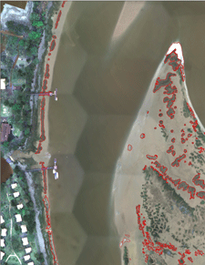 This dataset contains mapped boundaries of intertidal oyster reefs and washed shell deposits found along the SC coast. Reefs were mapped through a combination of automated and manual techniques using 4-band (blue, green, red, near-infrared) digital orthophotos with a theoretical ground resolution of 0.25 meters. These photos were taken from 2003-2006 and can be downloaded. The project area covered those sections of the SC coastal zone where oysters had historically been mapped by the SC Department of Natural Resources (SCDNR) in the 1980’s. The area spans 122 USGS quarter quadrangles (DOQQs).
Sixty of the mapped DOQQs were ground-truthed by boat to assess accuracy. The initial mapping process met the overall minimum accuracy requirements of the project (80% correct classification) and was completed through a joint effort between Photo Science Inc. and SCDNR. Since 2006, low-altitude helicopter photography (see photo below) has been used to edit and update the initial data product. In 2016, 18.5% of the mapped oysters had been updated using helicopter photography. Edits and improvements to this data product are ongoing, and this dataset will be periodically updated.
A link is included below for a table that lists initial accuracy and editing status data by DOQQ. Accuracy scores listed were calculated for the initial product and do not reflect the results of low-altitude helicopter photography editing, so these scores should be considered to be the minimum level of accuracy for the edited areas. Areas covered and analyzed by low-altitude helicopter photographs can be considered to have the highest degree of accuracy. DOQQs that have not been edited by SCDNR should be used with caution. Due to variations in image quality and visibility of oysters, some localized areas may not be as accurate as reported values. In particular, some of the oyster flats with sparse or patchy oyster coverage were difficult to map. Instructions and links are provided below for access to the data and associated metadata.
Project Partners include:
Viewing Oyster Reef Data

SC Intertidal Oyster Reefs Map Application
Download GIS Data
SCDNR_Oyster2015.zip (33mb) ESRI ArcGIS v10.3 File Geodatabase
| Layer Description: | Layer Names: | Layer Metadata: |
|---|---|---|
| SC Intertidal Oyster Reefs | Oyster2015Live | SCDNR_Oyster2015Live.html |
| SC Oyster Shell Deposits | Oyster2015Wash | SCDNR_Oyster2015Wash.html |
Accuracy and Editing Status
Available data set is subject to change and will be updated periodically.
Metadata about the editing status: SCDNR_Oyster2015_metadata_table.pdf
DOQQQ imagery is available at the following link, DOQQQ Imagery


Be the first to comment!