SC Governor orders Saturday evacuations of some barrier islands
McMaster orders Saturday evacuations of some barrier islands
| ||||||||||||||
|
McMaster orders Saturday evacuations of some barrier islands
| ||||||||||||||
|
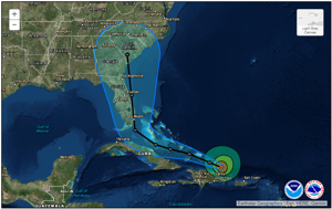
Record surge, ‘major’ storm conditions expected in South Carolina from Hurricane Irma
Surf will start to pick up Thursday, winds and rain by Saturday night. Hurricane Irma is due to make landfall in or near South Carolina late Monday or early Tuesday.
from Post and Courier, Charleston, SC
| ||||||||
|
For several years Cruisers’ Net has had reports of shallow water encountered near the eastern end of the Waterway’s passage through South Carolina’s Dawho River between the North and South Edisto Rivers. Our thanks to authors Bob and Ann Sherer for sharing their observations on the erroneous magenta line in this section. The Sherers have just released the 2017 edition of their ICW Cruising Guide, see /166170.
Hi Larry,
I wrote an article about a 5.5 MLW route through the shallows of the east entrance into the Dawho River, a notoriously shallow area of the ICW south of Charleston. It’s also where the magenta line can lead you astray as far as finding the deepest water. The article might be of interest to your readers so I’ve included a link if you think that’s the best way of presenting the information.
Here’s the link to the article:
http://fleetwing.blogspot.com/2017/08/dawho-river-beware-magenta-line.html
Thanks, Bob Sherer
aka Bob423
Click Here To Open A Chart View Window, Zoomed To the Location of Dawho River

Our thanks to Harbourmaster Nancy Cappelmann for keeping us all updated on post-Matthew conditions at one of everyone’s favorite Waterway stops. And, of course, Harbour Town Yacht Basin on Hilton Head’s Sea Pines Resort is A SALTY SOUTHEAST CRUISERS’ NET SPONSOR!
We are excited to announce that Harbour Town Yacht Basin has restored electrical service to approximately 50% of the slips. WiFi will not be available until the electrical installation is complete, however all of the amenities of The Sea Pines Resort are in fabulous condition and available to our visiting boaters.
Thank you for all your assistance as we have worked our way through the rebuilding process. I will continue to keep you updated on our progress.
And thank you for the nice letters and stickers. We have proudly displayed them on our front door!
| Nancy Cappelmann Harbourmaster, Harbour Town Yacht Basin 149 Lighthouse Road Hilton Head Island, SC 29928 Office 843.363.8335 Fax 843.671.0433 NCappelmann@seapines.com |
Click Here To Open A Chart View Window, Zoomed To the Location of Harbor Town Yacht Basin
Like earlier reports, this discussion implies a higher than normal 2017 storm season.
The Madden-Julian Oscillation is an oscillation is a fluctuation in tropical weather that stirs thunderstorms. If the water’s hot enough, those storms can strengthen into tropical cyclones.
CLICK HERE FOR THE FULL REPORT from Charleston’s Post and Courier
The waterway passing McClellanville all the way to the Ben Sawyer Bridge has been shoaling for years. And, as Phillip Mullins advises, SSECN still recommends mid to high tide for passage through this section.
Good water up to Jeremy Creek, then you have to wait at least 1 hr. after low tide. Stayed on magenta line all the way to red day mark 42. I draw 5 ft and came through 2 spots that were 4.8 ft but was able to plow through. Rest of the time had 6.0 ft or better. If you are not comfortable with this, I suggest you wait until 2 hrs after low tide.
![]() Click Here To View the Cruisers’ Net’s “AICW Problem Stretches” Listing For McClellanville
Click Here To View the Cruisers’ Net’s “AICW Problem Stretches” Listing For McClellanville
![]() Click Here To Open A Chart View Window, Zoomed To The Northern Portion of This AICW Problem Stretch
Click Here To Open A Chart View Window, Zoomed To The Northern Portion of This AICW Problem Stretch
Myrtle Beach Yacht Club on Coquina Harbor has been a great stopping place and a friend to cruisers for years. Naturally, they are A SALTY SOUTHEAST CRUISERS’ NET SPONSOR! The entrance to Coquina Harbor lies on the north side of the Waterway opposite Marker #13. Our thanks to Charles Ridley for this report.
7-5-17. Left Harbor Village at 6:15am. Beautiful day all day. Changed plans when realize get into Southport way too early and changed to MBYC at mm346. Fueled up– 80 gal/stb. And 62.2 in port -total 141.6. With Boat US dockage was $34!!! (my boat is 34″) $5 for electricity- 30 amp. Gene was as competent as cute helping us dock and take on fuel. Have a pass to get in the club’s grill- taco and tequila sunrises on very special! Shower secure, clean and even the soap dispensers had soap. Wifi strong on A-10. Easy to take dog out. No current and maybe a foot tide fall. Docks in great shape. We are here for only 1 night but may be a very good place for several days since so much going on around here. We will be back – most definitely.
Charles Ridley
Click Here To Open A Chart View Window, Zoomed To the Location of Myrtle Beach Yacht Club

Georgetown and Harborwalk Marina, both SOUTHEAST CRUISERS’ NET SPONSORS, continue to do everything possible to make your visit a special one. Located on the Sampit River, Harborwalk Marina is only a boardwalk away from Georgetown’s Historic District for history, entertainment, great food and shopping.
Enjoy Georgetown – a great stop. As with any cruising along the GA, SC and NC coasts, be mindful of tides and follow markers carefully. We strongly recommend Harbor Walk Marina in Georgetown – pet friendly for sure and immaculate restrooms/showers. Be sure to tell Chris, the owner/dockmaster, hello from Midas Touch.
Mike and Marian Warlic, on AGLCA’s Forum
Click Here To View the Cruisers’ Net’s South Carolina Marina Directory Listing For Harborwalk Marina
Click Here To Open A Chart View Window, Zoomed To the Location of Harborwalk Marina
We have spent MONTHS at Harbor Walk and love both Georgetown and the team at the marina. Be sure to visit Radar and crew at Coffee Break Cafe and enjoy their superior omelets. Shrimp & Grits are excellent at the River Room, Aunnie’s Country Kitchen has excellent eats. Be sure to see the SC Champion Oak next to the Indigo Society Hall. Our dogs loved the place and had great fun on many extended walks. For 5 years we spent one month going south and another month going north in this excellent town.
Cap & Linda
S/V Zydeco, B473
I would agree 100%!!!!
I would also agree 100%!!!!
Windmill Harbour Marina, A SALTY SOUTHEAST CRUISERS’ NET SPONSOR, is located on Skull Creek, on the shores of Hilton Head Island. Our thanks to David and Jacquelyn for sharing these beautiful sunset photos from their delightful blog.
CLICK HERE for The Voyage of Elske on America’s Great Loop
Click Here To Open A Chart View Window, Zoomed To the Location of Windmill Harbour Marina
Pierside Boatworks is now Charleston Boatyard Marina!
Pierside Boatworks has sold and is now operating as Charleston Boatyard Marina, LLC. New owners and boat enthusiasts Andy Oberdier and Peter Ulber are ready to transform it into Charleston’s modern and easy to use Boatyard. We are excited to keep you up to date on all the latest developments and plans.
If you are interested in contacting us for service, questions, or just to say hi, please contact us!
Call us at the same number: 843-554-7775
Email us for service: service@charlestonboatyard.com
VIsit us on the web: www.charlestonboatyard.com
We will be revamping our website and Facebook page shortly. Also look for promotions and discounts arriving soon.
Paige Haines
READ MORE
Click Here To Open A Chart View Window, Zoomed To the Location of Charleston Boatyard
The information is incorrect. Pierside closed its operations. Charleston Boatyard operates at the location that Pierside used to operate. Charleston Boatyard is not Pierside.
Be sure to see FOCUS ON Windmill Harbour Marina, A SALTY SOUTHEAST CRUISERS’ NET SPONSOR, which is located on Skull Creek, on the shores of Hilton Head Island. Our thanks to David and Jacquelyn for sharing their delightful blog.
After successfully navigating the challenging Fields Cut, we enjoyed immensely our first day on South Carolina rivers.
Elske is now berthed at Windmill Harbour, Hilton Head, South Carolina. She will reside here for the month of June.
Windmill Harbour is a lock-controlled harbour which means it is about as safe a boat could be. There are no tides or current. Barnacles don’t grow in this harbour. Elske is very happy here.
We are looking forward to exploring Hilton Head Island during our sojourn here.
David and Jacquelyn
CLICK HERE for The Voyage of Elske on America’s Great Loop
Click Here To Open A Chart View Window, Zoomed To the Location of Windmill Harbour Marina
Welcome to Windmill Harbor and the best marina staff around!
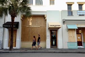
The Harborage at Ashley Marina lies along the northeastern shores of Ashley River (on the Charleston peninsula) between the charted 56 foot fixed bridge and the 18-foot Highway 17 bascule bridge. Initial findings indicate that this fire was related to fueling.
CHARLESTON, SC (WCSC) –
Authorities are working to figure out what caused a boat to explode and catch fire at the Harborage at Ashley Marina Monday morning.
CLICK HERE FOR REPORT AND VIDEO from live5 news.com
Click Here To Open A Chart View Window, Zoomed To the Location of The Harborage at Ashley Marina
Not good but at least is was close to face dock. Hope no one was aboard.
Good thoughts on safe boating from SCDNR.
Back to Basics . . .
by David Lucas
Boating Safety should be the business of everyone that plans to spend time on the water.

You might guess that someone who’s spent as many years as I have working for the S.C Department of Natural Resources would be an expert boater, but you’d be wrong. Growing up, my family didn’t own a boat, and when we’d got the chance to go out fishing or riding on the lake, it was generally with someone else — friends or extended family. Later in life, even though boating held some interest for me, there was always something else that was more of a priority to spend the time and money on. So, boating experiences were fairly few and far between, and almost always involved someone else at the controls. That’s actually the case for many adults who take up boating later in life, and for those folks in particular, a solid grounding in the basics of safe boating is key to enjoying their new hobby. READ MORE
Georgetown and Harborwalk Marina, both SOUTHEAST CRUISERS’ NET SPONSORS, continue to do everything possible to make your visit a special one. Located on the Sampit River, Harborwalk Marina is only a boardwalk away from Georgetown’s Historic District for history, entertainment, great food and shopping.
HARBORWALK MARINA
525 Front Street ! Georgetown, 29440 ! PO Box 274 ! Phone: 843-546-4250
E-Mail: stay@harborwalkmarina.com Web: www.harborwalkmarina.com
May 9, 2017
Harborwalk Marina Expansion/Renovation
Georgetown SC
Harborwalk Marina of Georgetown, SC, will double its capacity to serve transient boaters on the Intracoastal
Waterway with an expansion expected to be completed by September. [expand title =”Read More!”]
The marina, an affiliate of Evening Post Industries located on the Sampit River at the foot of Queen Street in
Georgetown, broke ground May 1 on the project that will add 825 linear feet of new floating dock that includes a
new 100-foot fuel dock with new high-flow dispensers for gasoline and diesel.
Improvements will also include a fuel hut on the dock for more convenient transactions, including ice and pump-out
service, over 385 feet of new bulkhead and drainage allowing the marina to be dredged to 8 feet MLW, and
improvements to parking and the marina building that will follow.
“Harborwalk Marina accommodates over 1,600 individual boats a year,” said manager Chris Carroll. “This brings a
major economic boost to the downtown Georgetown area. We are the closest marina to the downtown, and many of
our customers shop and dine on Front Street.
The marina, formerly known as Gulf Auto Docks, has been a Georgetown boating landmark for years. It was
purchased by Evening Post Industries in 1989. It was renamed Harborwalk Marina in the mid-1990s. A major
renovation in 2008 provided travelers with a new building offering climate-controlled showers, restrooms and
laundry facilities, 725 linear feet of floating transient overnight dockage with WiFi, cable TV and clean municipal
water seven days a week. With 7 to 12 feet of depth, the marina can accommodate vessels up to 200 feet. The
building provides space to sell ice, batteries, oils, soaps, shirts, hats and boat supplies along with a wide porch and
rocking chairs for travelers to enjoy the sunsets over Winyah Bay. Hours of operation are 8:30 a.m. to 6 p.m. daily.
“We like to think, we are not the biggest marina on the ICW,” Carroll said, “but we are one of the best.”
Click Here To View the Cruisers’ Net’s South Carolina Marina Directory Listing For Harborwalk Marina
Click Here To Open A Chart View Window, Zoomed To the Location of Harborwalk Marina
Harbour Town Yacht Basin, A SALTY SOUTHEAST CRUISERS’ NET SPONSOR, is now essentially open, offering fuel sales and transients slips with water, but no electricity. As stated below, full service is expected to be restored in June. This definitely good news for Spring cruisers! Our thanks to Harbourmaster Nancy Cappelmann for this update.
The marina is now open to transient guests, however, we are still under construction and have limited amenities on the docks. In other words, we have running water.
Our electrical contractor is on site and is working on the new electrical installation, and we should have power restored to some docks in the next 30-45 days. The full marina may not be restored till fall.
Our commercial dock is in place and all of our charter operators are in full swing.
Our fuel dock is open and fully operational.
The Sea Pines Resort is fully operational and all of the restaurants, golf courses, tennis courts, fitness center, beach…all of the amenities are in fantastic condition. [See /164092 and /164507]
While we still have construction ahead, we are very grateful to all of our contractors for their commitment to this project and to all of our returning guests for their patience and understanding. We look forward to the day we are running on all cylinders.
Please let me know if you have any questions.
We appreciate your support!
Nancy
Nancy Cappelmann
Harbourmaster, Harbour Town Yacht Basin
149 Lighthouse Road
Hilton Head Island, SC 29928
Office 843.363.8335
Fax 843.671.0433
NCappelmann@seapines.com
This incident confirms the wisdom of advice always given by the USCG to stand clear of dredge equipment. Dredging in the southern Waterway has become so common that boaters often ignore published warnings of less easily seen dredge equipment in support of the clearly visible dredge vessel.

News Release
April 9, 2017
U.S. Coast Guard 7th District PA Detachment Jacksonville
Contact: Coast Guard PA Detachment Jacksonville
Office: (904) 714-7606/7607
After Hours: (305) 318-1864
Coast Guard rescues 3 boaters after accident near Ravenel Bridge
CHARLESTON, S.C. — The Coast Guard rescued three boaters Sunday after their vessel struck a dredge near the Ravenel Bridge.
Coast Guard Sector Charleston Command Center watch standers received a notification of a boater whose vessel struck a dredge ejecting two boaters into the water at 12:24 a.m.
A Coast Guard Station Charleston 29-foot Response Boat–Small boatcrew launched and an MH-65 Dolphin helicopter crew in the area diverted to assist. Two Charleston County Sheriff marine units also responded.
The RB–S boatcrew arrived on scene at 12:47 a.m. and recovered one boater who was sitting on top of the dredge. A Charleston County Sheriff marine unit recovered the other two boaters.
The three boaters were transported to the Charleston Maritime Center where EMS were waiting.
The condition of the boaters is unknown at this time and South Carolina Department of Natural Resources is conducting an investigation.
And from Charleston’s Post and Courier:
Three rescued after boat crashes into dredge pipe near Ravenel Bridge
By Angie Jackson ajackson@postandcourier.com Apr 9, 2017 Updated 12 hrs ago (0)
Three boaters were rescued early Sunday after their vessel struck a dredge pipe in the Cooper River near the Arthur Ravenel Jr. Bridge, according to the U.S. Coast Guard.
CLICK HERE FOR THE FULL REPORT
Click Here To Open A Chart View Window, Zoomed To the Location of Ravenel Bridge
Click Here To Open A Chart View Window, Zoomed To the Location of Charleston Harbor Marina
Wounded Nature-Working Veterans organizes cleanups to address the many wildlife critical coastal areas that have never been cleaned. If you would like to volunteer and if you have a suitable boat (see below), the next scheduled cleanup is April 22.
Public beach and roadside cleanups benefit the travel & tourism Industry. Our coastal cleanups benefit wildlife. 
Improving South Carolina’s Seafood Population and Production!
On March 25th, 2017, Boeing, Bosch, Charleston Southern University Women’s Volleyball Team, SC Department of Natural Resources, Fish and Wildlife Service and the general public worked with Wounded Nature – Working Veterans to make a real coastal difference.
Trash and debris that poison, entangle and injures marine wildlife was removed from Charleston Harbor. In place of the trash and debris, an oyster bed that we started laying last year, was extended and has begun filtering the water around this island.
Getting wet, dirty, smelling like pluff mud, feeding the mosquitoes, gnats and flies, acquiring some scratches, scrapes and cuts is just a small part of what these volunteers endured to make a real coastal difference.
Cleanup news
Coastal Cleanup April 22nd, 2017
Capers Island
Low tide is 11:23. Wounded Nature boats should leave the ramp around 8:30 and spend several hours removing trash and debris from the high tide line area.
Meeting location:
We will be launching from the Buck’s Hall Boat Ramp. We will be performing this coastal cleanup in conjunction with the Power Boat Squadron.
Currently, we cannot take on any additional volunteers for this project unless they have a boat and are willing to return with some trash and debris in their boat.
Overnight primitive camping on the beach will be available with a permit from SC DNR. Permits available at: http://www.dnr.sc.gov/mlands/specregshp.html
At Wounded Nature-Working Veterans we organize cleanups to address the many wildlife critical coastal areas that have never been cleaned. Most areas can only be accessed by boat. For us, there is no need to further study the problem, we are focused on remedial action and getting tons of trash and debris removed from our coastal areas. We do make a real difference! Our work results in increased fish and shellfish populations and reduced debris deaths for dolphins, manatees, sea turtles and endangered coastal wildlife.
Small personal donations allow us to carry out our greatly needed mission!
Harbour Town Yacht Basin at Sea Pines Resort has been closed due to damage from Hurricane Matthew. They now can offer fuel sales and a few transient slips with water, but no electricity. Harbour Town Yacht Basin hopes to return to full service in June. Our thanks to George Williams for this report which has been confirmed by phone call.
This marina is up and running bought gas with boat/us discount for 3.30.9/gal yesterday.
George Williams
Click Here To Open A Chart View Window, Zoomed To the Location of Harbor Town Yacht Basin
This extension of the Wappoo Creek wake zone is between the HWY 30 Connector Bridge at Mile 470 and the Wappoo Creek Bridge at Mile 471, an open stretch of water bordered by a number of homes and docks. Wappoo Creek joins Elliott Cut to connect the Ashley River and the Stono River south of Charleston. See History of Wappoo Creek for more on this area.

Wappoo wake zone to be extended
Wappoo ICW

Wappoo Creek looking north from HWY 17 Bridge
Due to increased boating traffic, the South Carolina Department of Natural Resources (SCDNR) is extending the Wappoo wake zone of the Intracoastal Waterway in Charleston County.
The seasonal wake zone will be extended north to about 200 yards south of the James Island connector bridge, and south to the entrance of Coburg Creek. The extension will be in effect April 15, 2017, through Sept. 15, 2017. The normal wake zone will remain in effect until April 15 and will start again after Sept. 15.
This is one of the busiest stretches of water within the entire state, and law enforcement wants to minimize the risk for accidents.
“This is a popular area because there are two public boat landings within one mile of each other,” SCDNR Cpt. Donnie Pritcher stated. “The traffic has grown tremendously over the years and we want to keep people safe.”
For questions regarding the wake zone extension, contact the SCDNR law enforcement investigations office at 843-953-9378.
Click Here To View the South Carolina Cruisers’ Net Bridge Directory Listing For Wappoo Creek Bridge
Click Here To Open A Chart View Window, Zoomed To the Location of Wappoo Creek Bridge
Northern Fields Cut is always an area to approach cautiously and at mid to high tide. Our thanks to Mike Cam for this marker warning.
Sat. 4 March 17 Fields Cut just into SC. At 0850 about 1h 50m after mlw and 1.5ft above mlw northbound N48A LOOKS like it’s out of place, too close to the SE shore. It is not! Honor it but hug it. Saw 7ft. Our catamaran was very close to shore to starboard [northbound].
![]() Click Here To View the Cruisers’ Net’s “AICW Problem Stretches” Listing For Northern Fields Cut
Click Here To View the Cruisers’ Net’s “AICW Problem Stretches” Listing For Northern Fields Cut
![]() Click Here To Open A Chart View Window, Zoomed To This AICW Problem Stretch
Click Here To Open A Chart View Window, Zoomed To This AICW Problem Stretch


Be the first to comment!