Boats are Being Abandoned on SC’s Shores
Our thanks to Ted Ariska for posting this article in Save South Carolina’s Anchorages.

Boats are being abandoned on SC’s shores. Why? And what’s being done about them?
Island Packet
Our thanks to Ted Ariska for posting this article in Save South Carolina’s Anchorages.
Boats are being abandoned on SC’s shores. Why? And what’s being done about them?
Island Packet
A spooky South Carolina legend for Halloween!
South Carolina’s ghostly Gray Man legend offers lessons in hurricanes and shared stories
Post and Courier
Wounded Nature-Working Veterans, a nonprofit group, organized Wednesday’s cleanup, working with the Coast Guard and DNR crews to clear five vessels from the Intracoastal Waterway. About 15 derelicts still remain in Horry County’s ICW.
Wounded Nature-Working Veterans is a group of veterans, non-veterans and active duty military personnel run by Captain Rudy Socha in the Charleston area. The non-profit volunteer organization is working to cleanup, preserve and protect our coastal environment, particularly from derelict vessels.
Hunt the owners down and force them to pay all fees required to clean up "their mess".
Perhaps allow a community group to assist and make it like a treasure hunt.
Elba Island Cut is a maintained channel on the Georgia side of Savannah River across from Fields Cut in South Carolina.
GEORGIA – SAVANNAH RIVER AND WASSAW SOUND – SAVANNAH RIVER/AICW: Dredging operations.
On or about October 5, 2021 Goodloe Marine will begin dredging operations in the Atlantic Intracoastal Waterway (AICW) at Elba Island Cut just south of the intersection of the AICW and the Savannah River in Georgia. The cutter dredge EXEL will be removing shoal material from the AICW and pumping the material thru a 20” submerged pipeline across the Savannah River to an upland spoil area on the north side of the Savannah River. Mariners are cautioned to pass dredge at an idle speed and be mindful of numerous buoys and floating pipelines in and near the navigation channel. The dredge can be contacted on channel 16 and 68 for passing instructions. Additional information can be obtained by contacting Ben Goodloe 813-355-7494. Dredging operations are expected to be complete by Nov 15, 2021. For further information, please contact the United States Coast Guard at (912) 247-0073. Chart 11512 LNM 39/21

Wounded Nature-Working Veterans is a group of veterans, non-veterans and active duty military personnel run by Captain Rudy Socha, a former Marine turned conservationist. The non-profit volunteer organization is working to cleanup, preserve and protect our coastal environment, particularly from derelict vessels.
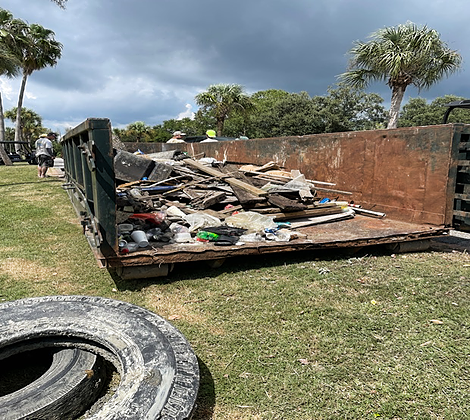
Results from the cleanup!
Wounded Nature-Working Veterans

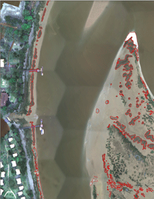 This dataset contains mapped boundaries of intertidal oyster reefs and washed shell deposits found along the SC coast. Reefs were mapped through a combination of automated and manual techniques using 4-band (blue, green, red, near-infrared) digital orthophotos with a theoretical ground resolution of 0.25 meters. These photos were taken from 2003-2006 and can be downloaded. The project area covered those sections of the SC coastal zone where oysters had historically been mapped by the SC Department of Natural Resources (SCDNR) in the 1980’s. The area spans 122 USGS quarter quadrangles (DOQQs).
Sixty of the mapped DOQQs were ground-truthed by boat to assess accuracy. The initial mapping process met the overall minimum accuracy requirements of the project (80% correct classification) and was completed through a joint effort between Photo Science Inc. and SCDNR. Since 2006, low-altitude helicopter photography (see photo below) has been used to edit and update the initial data product. In 2016, 18.5% of the mapped oysters had been updated using helicopter photography. Edits and improvements to this data product are ongoing, and this dataset will be periodically updated.
A link is included below for a table that lists initial accuracy and editing status data by DOQQ. Accuracy scores listed were calculated for the initial product and do not reflect the results of low-altitude helicopter photography editing, so these scores should be considered to be the minimum level of accuracy for the edited areas. Areas covered and analyzed by low-altitude helicopter photographs can be considered to have the highest degree of accuracy. DOQQs that have not been edited by SCDNR should be used with caution. Due to variations in image quality and visibility of oysters, some localized areas may not be as accurate as reported values. In particular, some of the oyster flats with sparse or patchy oyster coverage were difficult to map. Instructions and links are provided below for access to the data and associated metadata.

SC Intertidal Oyster Reefs Map Application
SCDNR_Oyster2015.zip (33mb) ESRI ArcGIS v10.3 File Geodatabase
| Layer Description: | Layer Names: | Layer Metadata: |
|---|---|---|
| SC Intertidal Oyster Reefs | Oyster2015Live | SCDNR_Oyster2015Live.html |
| SC Oyster Shell Deposits | Oyster2015Wash | SCDNR_Oyster2015Wash.html |
Available data set is subject to change and will be updated periodically.
Metadata about the editing status: SCDNR_Oyster2015_metadata_table.pdf
DOQQQ imagery is available at the following link, DOQQQ Imagery
|
More watercraft were involved in crashes along the Intracoastal Waterway in Myrtle Beach than anywhere else in the state last year, according to a 2020 report from the South Carolina Department of Natural Resources.
Intracoastal Waterway in Myrtle Beach leading state in boat crashes, data shows
WBTV.com/news
Safety concerns increase as more boaters enjoy the Intracoastal Waterway | WPDE
wpde.com
We made the mistake, while traveling north on the ICW, of passing through the Myrtle Beach section on a Sunday in April. It was awful. We are in a 36foot sailboat. There were many many jet skis buzzing past, swerving in and out. Power boats passing us very closely! It was the most dangerous part of our trip.
Susan Woods Bamonto don’t forget the over loaded boats and some towing people on tubes…and the day started so beautifully.
I'm not surprised the Myrtle Beach area ICW leads in boat crashes. We see all kinds of craziness whenever we travel through there and I have a photo that says it all.
The Lowcountry Maritime School of Charleston, SC was organized to promote and support their primary mission: educating youth through boatbuilding and maritime skills.

Click here for LMS August 2021 Newsletter
This photo of reckless boating on the ICW in Myrtle Beach was submitted in support of comments made by Phil Barbalace regarding Myrtle Beach Leads State in Intracoastal Waterway Boat Crashes. Thank you for sharing Phil! One picture says more than a thousand words.
.

Our thanks to Ted Arisaka for this report on a continuing debate over oyster farming and anchoring rights. See LNM: Oyster Beds to be Installed, Steamboat Creek and Oyster Farming Dispute Again in the News.
About 6 months ago, I made a request to Kyle Ward of NOAA, to consider charting the mariculture area in Steamboat Creek (south of Charleston) as establish in the USCG Local Notice to Mariners District 7 Week 49 of 2020.

Click Here To View the Cruisers Net South Carolina Anchorage Directory Listing For Steamboat Creek
Click Here To Open A Chart View Window, Zoomed To the Location of Steamboat Creek
|
|

Intracoastal Yacht Sales, a long-time CRUISERS NET SPONSOR, offers full service brokerage representation from three locations: Wrightsville Beach, NC, Little River, SC and Charleston, SC. You will want to see this exceptional cruising vessel! Click link below for full details,


Carolina Breeze – 2002 44′ CARVER 444 Cockpit Motor Yacht
Folly Beach South Carolina United States
$224,900 USD
My wife and I purchased this Carver444 in 2002. Took delivery in Wilmington, NC in June. We cruised her until 2012 when family situations caused us to sell her . She has had only two owners in her 19 years… and two owners who cared very much for her. It is our hope that she finds a new owner who will enjoy her and care for her as the past two owners have. She will bring you many happy times and wonderful lifetime memories.
Her first name was "WinSue" and now she is "Carolina Breeze"….
Intracoastal Yachts knows this boat well and will be looking for her new owner. Bobby Gregory was involved when we sold her and has her in his care again.
Above-normal tropical activity, new ‘normals’ in the Atlantic and steering robotic surfboards into hurricanes.

Sponsored by Lowcountry Foundation Repair

Good morning, readers.
Hurricane Wire is back and ready to bring you details of everything brewing in the Atlantic basin this season.
Experts believe we could be in for another busy tropical season but nothing quite as bad as what was experienced in 2020. Last year was a record-breaking one with 30 named storms, 13 hurricanes and six major hurricanes. The National Oceanic and Atmospheric Administration does not believe this hurricane season will be as active as the last.
In a 2021 Atlantic hurricane outlook released last month, NOAA’s acting administrator Ben Friedman said the agency projects a 70% probability of 13 to 20 named storms, six to 10 hurricanes and three to five major hurricanes.
This may seem like quite a bit of projected tropical activity, but the baseline of “normal” changed in 2021 when meteorologists updated the 30-year period they use to determine average weather benchmarks. Moving forward, an average Atlantic hurricane season will have 14 named storms, seven hurricanes and three major hurricanes.
So technically, NOAA’s predictions for this season are considered normal. Our Chloe Johnson reports that new weather benchmarks are reflecting a more active Atlantic season. However, scientists still disagree on whether climate change will lead to more hurricanes over the long term. Read more about that here.
Researchers with the Tropical Meteorology Project at Colorado State University predict there will be 35 days in which a hurricane is active this season, and nine days in which a major hurricane is active. Their forecast for the 2021 hurricane season nearly mirrors the Project’s early prediction for the 2020 season. But last year exceeded expectations in many ways.
Only time will tell what is in store for the Atlantic this year. So for now, let’s just stay vigilant.

Conditions: Nothing is spinning in the Atlantic, but the National Hurricane Center has issued advisories on tropical depression Blanca located in the eastern Pacific. This is not a concern for South Carolina as the depression is several hundred miles south-southwest of the southern tip of the Baja California peninsula.
Computer models: The Carolinas are expected to remain clear of threats for the foreseeable future.
Outlook: Tropical cyclone formation is not expected in the Atlantic basin during the next five days.

From 1981 to 2010, there were, on average, 12.1 named storms, 6.4 hurricanes and 2.7 major hurricanes of Category 3 or above each year.
In the new period, 1991 to 2020, there were an average of 14.4 named storms, 7.2 hurricanes and 3.2 major hurricanes each year, according to data analyzed by Brian McNoldy, a senior researcher at the University of Miami.

On May 7, 2015, surf powered by a tropical depression lured a stand-up paddle boarder into the water on Isle of Palms. The storm would become Tropical Storm Ana, with wind gusts reaching 60 mph near Little River and Cherry Grove Beach. (File/Staff)

Have a question about how hurricanes work, how we cover them or any other storm-related questions? Reply to this email and we may feature your question in an upcoming newsletter!
Like what we’re doing with Hurricane Wire? Forward this email to a friend!
If you haven’t signed up for Hurricane Wire, you can sign up for this weekly email here.
Visit our Hurricane Wire Hub for more storm coverage throughout the week.
Hurricane Wire is a collaborative project produced by a team of Post and Courier journalists. Shamira McCray is its lead writer. Data visualizations are created by Bryan Brussee. “Hurricane in history” photos are curated by Matthew Fortner. The newsletter is produced and edited by Emily Daily and Matt Clough.
Recommended for You

Keep up with the latest climate change and environmental issues impacting the Lowcountry and the rest of South Carolina. In your inbox, every Monday.
SC House Bill 3865 was passed and signed into law May 17 and will take effect July 1, 2021. Our thanks to Ted Arisaka for alerting us to this legislation.
A local government may adopt an ordinance requiring a permit for a watercraft or floating structure to remain moored, anchored, or otherwise located in any one five-mile radius on public waters within its local jurisdiction for more than fourteen consecutive days. The cost of a permit required by a local government may not exceed fifteen dollars. An ordinance adopted pursuant to this subsection must not apply to watercraft:
South Carolina House Bill 3865
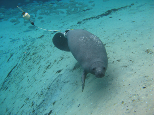
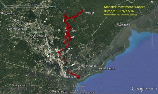
As manatees return to their summer haunts along the coast, South Carolina Department of Natural Resources (SCDNR) and U.S. Fish and Wildlife Service (USFWS) biologists are reminding residents and visitors to boat carefully and report sightings of these gentle giants online.
|
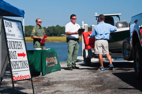
To help prepare for the Memorial Day holiday weekend, SCDNR will be holding courtesy boat inspections across the state.
|
Our thanks to Ted Arisaka for these reports from SC journalists. See Oyster Farming Dispute.
As you know, in Georgia, the “approved” shellfish harvest areas greatly impinged upon anchorages. Here is an investigative report on alleged conflict of interest in neighboring South Carolina.
Ted Arisaka
Shell game: Conflict, secrecy cloud battle over SC oyster farming permit
Charleston Post Courier
Uncovered: Conflict, secrecy cloud battle over SC oyster farming permit
Index-Journal
As much as we might wish to participate, we can’t always put on our gloves and boots and wade into the fray. So here is your opportunity to contribute to the efforts of this fine volunteer group to clean up Charleston’s waterways on our behalf. Please give what you can!

Wounded Nature – Working Veterans needs your help! We clean and rehabilitate critical coastal areas that others cannot reach: Trash/Debris, Treated Wood/Tires, Abandoned/Derelict Vessels.
We make a Real Coastal Difference but doing this requires the right equipment. 2021 is our year to grow and upgrade our 20+ year old boats with two proper workboats. With the right equipment, we will increase our capacity and reach to do more by going after the really tough to get stuff – big treated wood (dock pilings/telephone poles), buried tires, and all the stuff we’ve been seeing but unable to remove to date.
Please consider donating. We have three levels of “perks” so check out the link. https://igg.me/at/WoundedNature/
Sharing this fundraiser with your network is just as impactful so please SHARE away to help Wounded Nature – Working Veterans continue to MAKE A REAL COASTAL DIFFERENCE in 2021 and for years to come!
Thank you all for your support!
Whit Jones
Wounded Nature – Working Veterans
843-737-1088


Comments from Cruisers (1)
The problem is NOT owners abandoning their boats. The problem is typical government bureaucracy unable to take charge, FINE the most recent owners of these boats AND make THEM pay for removal. Just complaining about abandoned boats does not effect a solution.