


Navigating Gulf Weather during November – Fred Pickhardt
Fred Pickhardt’s Substack is free today. But if you enjoyed this post, you can tell Fred Pickhardt’s Substack that their writing is valuable by pledging a future subscription. You won’t be charged unless they enable payments.
Navigating Gulf Weather during NovemberA Mariner’s Guide to Gulf Weather, Waves, and “Northers”
November brings a massive relief to Gulf mariners as tropical threats plunge—but it also ushers in a notorious structural hazard: the “Norther.” As late autumn settles across the US Gulf Coast, routing strategies completely shift from avoiding hurricanes to surviving punishing cross-sea conditions. Whether you are hugging the Texas coastline or making a crossing toward the Yucatan, here is what you need to know about routing, sea states, and the arrival of the classic Gulf cold front.
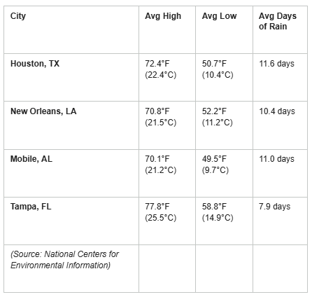
Gulf Port WeatherCoastal cities stretch across the region with relatively consistent rainfall (averaging 8 to 12 days of rain) and daytime highs resting comfortably in the 70s F (23-25 C).
Weather at SeaTemperatureTemperatures remain favorable for autumn sailing, with a noticeable warming as you travel south:
Source: PUB 106: Atlas of Pilot Charts North Atlantic Ocean (November)
Unlock the rest of this post, including our actionable checklists and complete data breakdown, by joining our community of paid subscribers today. … Keep reading with a 7-day free trialSubscribe to Fred Pickhardt’s Substack to keep reading this post and get 7 days of free access to the full post archives. |







Be the first to comment!