Visit Logged
  • Select Region
    • All Regions
    • VA to NC Line
    • North Carolina
    • South Carolina
    • Georgia
    • Eastern Florida
    • Western Florida
    • Florida Keys
    • Okeechobee Waterway
    • Northern Gulf
    • Bahamas
    • New York
    • Ohio
    • Pennsylvania
    • Washington
    • Puerto Rico
    • Minnesota
    • Maryland
    • Tennessee
    Order by:
    • Good Advice from Royal Marsh Harbour Yacht Club, Abacos, Bahamas

      Royal Marsh Harbour Yacht Club

      Royal Marsh Harbour Yacht Club is a premier yacht club in the Abacos and A CRUISERS NET SPONSOR! If you cruise to Abacos and Marsh Harbour area, you should consider joining this great group of like minded cruisers. 


      Did you know……if you are flying out for the holidays you should bring your cruising permit with you to avoid issues when you return to your boat here in the Bahamas.
      .
      Congratulations, you’ve arrived in the Bahamas on your own boat!  The holidays are fast approaching, and you might be flying home to be with family and friends or have another reason to fly out. When you are returning by air, the immigration agent will want to make sure you have a way to leave the Bahamas.  Your cruising permit is proof that you will be leaving on your own boat.  Without that proof you could be held up at the airport or refused entry.

       
      So, along with your passport make sure to pack your cruising permit.
       
      Safe travels!
      Until next time,
       
      Mary
       
      Be sure to join the RMHYC Facebook group for the most up to date information
      about our club and what’s going on in Abaco.

      Be the first to comment!

    • Introducing the New NAVCEN Maritime Safety Information Application!

      united states coast guard

      Dear Users of the Marine Transportation System,

      We’re excited to announce the launch of the U.S. Coast Guard Navigation Center’s new Maritime Safety Information (MSI) Application! This enhanced platform is designed to improve your access to critical navigation safety information, including Local Notices to Mariners (LNM) and Light Lists.

      Key Features of the New MSI Application:
      • Near-Real-Time Updates: Stay informed with the latest changes and updates.
      • GIS Display: Visualize navigation information directly on an interactive map.
      • Customizable Searches: Narrow your searches to focus on specific waterways or regions of interest.

      The application is available now and ready to support safer, more efficient maritime operations.

      Access the New MSI Application:
      Click HERE to explore the platform and take advantage of its features.

      We’re committed to ensuring mariners have the tools and information they need to navigate safely and effectively. If you have any questions or feedback, please don’t hesitate to reach out.

      Be the first to comment!

    • Merry Christmas! from the Dismal Swamp Canal Welcome Center


      Set in beautiful Camden Count, NC, the Dismal Swamp Canal Welcome Center provides free dockage for cruisers' on the Dismal Swamp AICW Alternate Route

      A SEASON’S GREETINGS from Dismal Swamp Welcome Center, A CRUISERS NET SPONSOR!  The Dismal Swamp Route departs the southbound Waterway at MM 7.2. Your southbound alternate is the Virginia Cut through Great Bridge, VA. 


       Sarah Hill, TMP
      Director, Dismal Swamp Canal Welcome CenterChairperson, Camden County Tourism Development Authority

      2356 US Hwy 17 North, South Mills, NC 27976

      252-771-8333 | shill@camdencountync.gov
      www.DismalSwampWelcomeCenter.com

      www.VisitCamdenCountync.com  

      Click Here To View the North Carolina Cruisers Net Marina Directory Listing For the Camden TDA/Dismal Swamp Canal Welcome Center

      Click Here To Open A Chart View Window, Zoomed To the Location of the Dismal Swamp Canal Welcome Center

      Be the first to comment!

    • Menorah Lighting at Fishermen’s Village, 7:00 PM, Saturday, December 28th


      Fisherman's Village Marina and Resort, Punta Gorda, FL

      There is always plenty to do around Charlotte Harbor, especially during the holidays. While berthed at Fishermen’s Village Marina, A CRUISERS NET SPONSOR, you are certain to enjoy visiting Western Florida’s beautiful Charlotte Harbor/Peace River.


      Click here for  Menorah Lighting press release 2024
       

      Click Here To View the Western Florida Cruisers Net Marina Directory Listing For Fishermen’s Village

      Click Here To Open A Chart View Window, Zoomed To the Location of Fishermen’s Village

      Be the first to comment!

    • High Cotton – Janice Anne Wheeler

      SPARRING WITH MOTHER NATURE ~~ latest addition. I’m very honored that you’re following along. Thank you from the bottom of my writer’s heart.

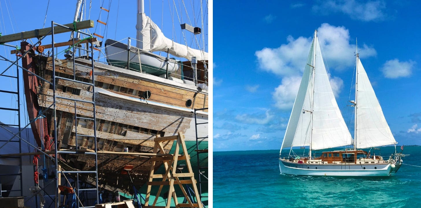
      Ah, the life of a liveaboard Sailor…on a Classic Wooden Sailing Yacht… as of August 2024 we are undergoing extensive repair and refit for the next several months(!). In boating terms we are hauled out “on the hard” in Cambridge, Maryland.

      I plan to mix Sailing Stories with the challenges and intricacies of restoring a 90-year-old boat. I’m always open to suggestions as to content….please feel free to weigh in as we manage and learn from this unexpected joust. Thank you! ~J

      A Wooden Boat is a strong, intricate entity constructed of Mother Nature’s finest materials.

      Share SPARRING WITH MOTHER NATURE

      Leave a comment


      HIGH COTTON

      Advantageous to All


      Be the first to comment!

    • Newest edition of Coastlines Georgia now available, Georgia DNR

      CRD Header May 2019 -2
      CRD Latest News
      Coastlines Georgia - December 2024 cover

      The winter 2024 edition of CRD’s quarterly magazine, Coastlines Georgia, is now available!

      Click here to visit the edition’s website for total access.


      In this edition:

      Navigating the Waters of Fishery Management

      CobiaThree important players in Georgia’s marine fishery management are the Georgia Department of Natural Resources’ Coastal Resources Division (CRD), the South Atlantic Fishery Management Council (SAFMC), and the Atlantic States Marine Fisheries Commission (ASMFC).

      These organizations may seem like they’re doing the same job, but each has a unique role, focus, and jurisdiction that shapes how they manage fisheries in Georgia and beyond.

      Let’s explore what each of these groups does, how they work together, and why their collaboration is critical for the future of South Atlantic fisheries.

      Read the article here.


      Regional Red Drum Stock Assessment Results Are In

      Photo by David CannonKey findings revealed a concerning trend: red drum in Georgia’s waters are both overfished (not enough fish in the population to reproduce at sustainable levels) and experiencing overfishing (too many fish being caught).

      Overfishing was determined based on a spawning potential ratio (SPR), which measures the reproductive capacity of the stock.

      The target SPR for sustainability is 40 percent, with a threshold of 30 percent defining overfishing. Recent estimates show SPR below the threshold, indicating overfishing is occurring. Similarly, spawning stock biomass (SSB), which measures the total reproductive stock, has declined, placing the population in the overfished category.

      Read the article here.


      Also inside:


      PDF Icon Click here if you prefer to read a PDF version of the magazine.
       
       
      Learn more about CRD on our YouTube Channel

      YouTube

      Support marine habitats by upgrading your license plate!

      tag


      Be the first to comment!

    • History of Currituck Beach Lighthouse, Outer Banks, NC – Kevin Spencer

      December 1st
       
      ON THIS DAY in North Carolina history…
       
      1875:
       
      ON THIS DAY, the last of the four Outer Bank Lights, the Currituck Beach Lighthouse, is lit. It fills in the dark hole from Bodie Island to Cape Henry, Virginia. It is virtually identical to its three sister lighthouses (Bodie, Lookout, Hatteras) in construction. The 162-foot tall tower is constructed of approximately one million bricks. Its foundation extends seven feet below ground, with walls that begin at 5.5′ thick at the base of its tower, then tapering to 3′ thick at the top. It took one and a half years to build, beginning in 1874, and cost around $178,000 to construct.
       
      For its outer appearance, Currituck is left with its natural red brick. The thought by experts is this was the best way to distinguish it from the barber swirls of Hatteras, the diamonds of Lookout, and the horizontal stripes of Bodie Island.
       
      Initially, the beacon is fueled by a mineral oil lamp with five concentric wicks, the largest of which was four inches in diameter. The light is fixed white with a red flash, which occurred every ninety seconds and had a five-second duration. A clockwork mechanism rotates the light. Directly underneath the light, it is powered by weights and has to be hand-cranked every 2 1/2 hours.
       
      Today the light is automated and has been since 1939. The light has a flash pattern of three seconds on, and seventeen seconds off. It can be seen for almost 19 miles out to sea. As part of the automation, the lighthouse also has an automated bulb changer that holds a backup bulb. The Currituck Lighthouse comes on at dusk and turns off at dawn.
       
      ~Kevin Spencer, Author, North Carolina Expatriates

      Be the first to comment!


    Social Media Auto Publish Powered By : XYZScripts.com