In addition to recent news of a fully operational pumpout boat, see /?p=119532, Capt.Hyde adds these perks to anchoring in Punta Gorda, A SALTY SOUTHEAST CRUISERS’ NET SPONSOR! on Western Florida’s Charlotte Harbor/Peace River.
To add to the amenities of anchoring off the Punta Gorda waterfront, new floating dinghy docks are now available in the recently dredged `lagoon’ behind the Punta Gorda Boat Club, just north of Fisherman’s Village. Noel Hyde
The Dismal Swamp Canal Welcome Center, A SALTY SOUTHEAST CRUISERS’ NET SPONSOR!, is located on the east shore of the Canal at Statute Mile 28. For the Center’s winter hours, see /?p=128131
I have now been retired 3 years, after 23 years as Director of the Dismal Swamp Welcome Center. I want to thank each and everyone who choose to travel the Dismal Swamp Canal. I realize the dockage is small but most the time it will meet your needs. It is the only place where you can witness nature at its best and learn of its history. Bike rides are available, clean restrooms and grounds. Try it once and I promise you will return’¦’¦..’Happy Cruising’ Penny Leary-Smith
The Welcome Center has provided so much needed respite over the years while cruising. The staff certainly are always very informative, and encouraging no matter what time of the day we have visited. Its great to have ‘˜the Dismal Swamp’ available to us; such a blessful experience ‘“ its like riding down a country lane viewing nature in its natural sitting. For me its a ‘˜slice’ of America, kinda like Yellowstone (a piece of history that I wish everyone could experience). My husband as well as fellow cruisers we know, are praying that tax dollars don’t ever allow it to go away. We encourage everyone to try it ‘“ along with a stop by to talk with Robert Peak & say `Hello’ to his pal, `U-Turn’; since he’s an extremely sweet pet, you might wish to have a doggie treat ready. Ginger Thompson
Penny, Thank you for all you have done. This applies to all your staff as well. It has always been one of our favorite stops. Jim and Sandy Davis S/V Isa Lei
Our good friends, and SSECN strategic partners, Captains Mark and Diana Doyle, founders and owners of “On The Water ChartGuides” (http://www.onthewaterchartguides.com/), give us an updated, graphic report below, relaying what they discovered as they navigated through the AICW – Little Mud River Problem Stretch on 11/20/13! Note that the Doyle’s soundings were taken near mid-tide, so to calculate MLW depths, you must subtract 4.8 feet from their figures. Applying this correction, Diana and Mark noted multiple MLW corrected 4-foot soundings along this perennial AICW Problem stretch. And, as Mark and Diana note, there are almost certainly even shallower spots. Our cruising duo are also quite right in noting that, “the reigning champion of this year’s ICW Trouble Spots is Georgia’s Little Mud River.” I might also add that very dubious distinction has been true of Little Mud River for many years now. If and until this AICW Problem Stretch is fully dredged, I would be hesitant to navigate anything bigger than a canoe through this portion of the Waterway at low tide!
Hi Claiborne, As I’m sure you’ll agree, the reigning champion of this year’s ICW Trouble Spots is Georgia’s Little Mud River. With depths as low as 4 FEET MLLW, Diana and I wanted SSECN readers to have this printable graphic of our November 20th survey report and depth-annotated track: Best wishes on this Thanksgiving holiday, Captains Mark & Diana Doyle m/v Semi-Local http://www.OnTheWaterChartGuides.com
Departing the Waterway at statute mile 375, four miles south of the Socastee Bridge, this “off-road” venture on the lovely, upper section of the Waccamaw River to the city of Conway, SC has pleased many cruisers and has proven to be a worthy side trip. And now Captain Thomason adds knowledge of a quiet, safe anchorage between Conway and the Waterway. This is very good news indeed, as, prior to this posting, we knew of no other place to spend the evening once the confines of the AICW were left behind, than to continue upstream to the city Marina at Conway. Now, there is a FREE alternative! Unfortunately, this upper section of the Waccamaw is not covered on any NOAA chart, so we must relay on Captain Thomason’s description below to find this anchor down spot. However, using the magic of “Google Earth,” we have isolated a satellite image of this body of water, which you will see on the upper, right corner of this posting! Has anyone else anchored on Cox Lake??? If so, we want to hear from you. Please share your experiences by making use of the “Comment” function at the end of this posting. We can’t wait to hear from you!
Dear Claiborne, Cox Lake is a body of water north east of R marker 16 (approximate location N33 47 683, W 079 03 102). Depart the marked route just south of R 16, proceed through the obvious opening to the lake. Depths going in are in the 7-9 ft range. We like to anchor directly across from the opening at the mouth of a wide cove, past a large dock to starboard in 12 to 14 ft of water or deeper in to the cove for shallower depths (10 ft or less). The deepest into the cove we have anchored is N33 47 856, W 079 03 102. Cox Lake is known to locals who sometimes anchor here to party but that’s only happened once for us (and they left at night). Other than the one dock, the shores are natural cypress. At one point there were a couple of very small homemade “houseboats” on the north side of the lake but they have been gone the last two times we anchored. The anchorage is not affected by wakes from boats on the river. A nice spot to pass a quiet night. Hope this helps! Cox Lake is approximately two and a half miles from Conway City Marina. Jean Thomason
The following restaurant review was posted by Captain Skip Gundlach in the St. Augustine Cruisers Net. The American Legion Post 37 is located at 1 Anderson Circle just north of the Bridge of Lions and within easy walking distance of the City Marina.
The Admiral and I just returned from a well-kept (well, we didn’t learn about it until this weekend, and we’ve been here 5 weeks) secret: The American Legion Post 37, on the corner at the circle just north of the bridge, is open to the public, with delicious food and drink, all of which are dirt cheap. We tried the leftover prime rib, which had been cut up and put into potato soup. Big bowl, $3, a meal in itself. Pig that I am, however, it was so good I had two. 3 bowls of soup, two beers and a coke ($1, keeps it filled, in an iced glass “glass”) came to $15 with tax. A $5 tip forced it to $20. Easily the best adult-beveraged dinner we’ve eaten here for value, and we loved it as well. Highly recommended. You ask, why were you eating out? The stove is on the saloon sole, and I’m having to CUT out 2 of the 3 burners we’re replacing. So far I’ve broken 6 bits for the Roto-Zip – gonna have to walk to Home Depot tomorrow… Still loving St. Augustine! Skip
You are ABSOLUTELY right about this being a best kept secret. I was a little leery of the article before reading it because I was afraid you were going to recommend the Santa Maria. The Santa Maria is responsible for more people getting sick on the food they serve than any other restaurant known in this area. There is a reason they advertise `You can feed the fish from your table.’ Even the fish won’t eat their food. Capt. Perry
We have enjoyed the legion on several occasions’¦.and you meet some really neat people there, too. Mark and Gwyn aboard sailing cat ALA
Hmmm’¦I’ll admit I don’t eat often at the Santa Maria in St. Augustine however, I’ve enjoyed the ravenous display by the fish eating the scraps dropped from our table. So I haven’t shared Captain Perry’s dining experience or illness from dining at the Santa Maria’¦ I HAVE enjoyed the hospitality of the Legion Post and admit that I have shared the `secret’ with our close friends but now that the word is out to the entire cruising community, everyone can enjoy this `under the radar’ secret. David Burnham
The alternate route discussed below by Captain Byron is the Umbrella Cut Route which takes you northbound from Mile 696 in Cumberland River through Floyd Creek, across the Satilla River and into the Little Satilla to rejoin the AICW at Mile 686 in Jekyll Sound. This is often considered the route of choice when the primary Waterway route through St. Andrew Sound is kicking up. If southbound, do NOT confuse Umbrella Cut with Umbrella Creek where severe shoaling has occurred.
11/25/13 Six years ago when we were headed south we used the Umbrella Cut successfully to avoid crossing St. Andrews Sound when the seas were running high. This year the winds were 20 knots from the northeast and we wanted to try it again but were surprised that there was no recent info. We checked with locals and decided to try it on a mid and rising tide. We found it is still a viable alternative. We timed our approach for 2 1/2 hours before high tide. Our boat is a 34 foot trawler with a 4 ft draft. There was a strong following sea and as we made the turn into the cut we were pushed out of the channel where we saw 7 ft. That gave us pause but we kept going and found nothing less than 9 or 10 all the way through. We stayed midchannel away from the markers and kept to the outside on unmarked curves. We transited the alternative route all the way through Fields Creek without incident. As we exited and rejoined the ICW shortly behind us came a 45 foot boat out of the channel as well. I hope this observation is helpful. Connie Bryon
We also took the umbrella cut October 14, 2012 due to seas being up. We went through at low tide and had only 1 depth alarm at 3 feet which I cleared immediately and the depth went back to 6 feet. Most of the passage we had depths of 5 to 8 feet. We stayed in the middle of the waterway when there were no markers. I was concerned about using the cut with the horror stories out there. We stoped at Jekyll Harbor Marina to ask the locals about the cut. They said they use it all the time and I would have no problem. We also had a 40+ foot sport fishing boat follow us through at low tide. Richard Clagett
Thank you all for the great post up, as we say on the big river. Am planning on going north on the AICW this coming spring and it has been very helpful hearing from light draft vessel operators! Capt. Jerry Robbins
Huckins Boat Yard is located on the northern shores of the Ortega River off the St. Johns River, just upstream of the Roosevelt Boulevard Bridge with a 45ft vertical clearance.
If you are going to be in the Jacksonville area on the Ortega River and need boat yard services, give Huckins Yacht Corporation a good look. We just finished a week of annual underwater hull maintenance and would have to proclaim this was the best boat yard experience we have had in over 15 years of boating. The yard hauled us out on the day scheduled, and then splashed us on the day promised, with everything on the original list completed plus adding another large amount of work that was unseen so not anticipated. The quoted costs on those things we could estimate were honored and the additional work was quoted as we went and that was honored. Then, to top it off, the yard spent 3 hours washing our boat before casting us off. This is a job I always hate to do when first leaving a yard with the usual dirty decks and Huckins included it in the packaged bottom job. As not having any incentive from Huckins except a very happy customer, I do highly recommend them. Call Deb Grant, one of the service managers, and tell her that we sent you. Stay safe, Tom
Huckins builds one of the best boats on the water too. Timeless classics with incredible quality. Brad Hines
Ditto this positive review of the Huckins Yard. They are a longtime custom boat builder with extensive facilities and equipment. They have weathered the down market in custom new-builds by cultivating their service operation. The workers are high-skill and conscientious, and management is on-site and responsive. Huckins has a reputation for being pricey, but their hourly rates are in-line with many yards, they go the extra mile to serve a customer, and their quality is such that you get full value for every dollar. They have worked on my boat several times, and I always leave satisfied.
The recent closure of the Great Bridge Lock, which temporarily made the Dismal Swamp Canal AICW Alternate Route the only inland option, prompted this discussion of the Dismal Swamp versus the North Carolina – Virginia Cut (a. k. a. the Albemarle and Chesapeake Canal) on the AGLCA Forum.
Obviously each boater makes their own decisions but the Dismal is my absolute preference over the Va Cut. that said I am a shallow draft boat (3′) and have keel protected props. I have found that there are different risks for both routes depending upon your individual boat. We always thump something coming thru the Dismal but so far no damage, and also the Pungo for that matter. The Va Cut bridges are difficult for us to time, as we are a slow boat so we are often waked badly by inconsiderate captains on large yachts transiting the Va. Cut making a schedule. There is commercial traffic on the cut as well and the long narrow channel reach across the Carrituck Sound in weather can be a real bear. I also find that the approaches to the bridges on the upper end of the Virginia Cut has it’s dangers with the stumps lining that narrow channel. Often not visible until they poke out from a wake trough. So for us the very protected easy relaxing transit of the Dismal is the attraction and it has many more anchoring/docking options than the cut. When weather blocks the crossing of the Albemarle we often hang out at Elizabeth’s (sometimes referred to as Robert’s) Dock between the Swing bridge and the deep creek lock chamber. Deep water extremely protected free dock with easy walking to the town that has everything the cruiser could require in the adjacent shopping Center. No electric and sometimes you can get water if the tap is on. We prefer this spot to trying to jam into Elizabeth City among a backlog of boats trying to wait a weather window. Again the decision is of course dependent upon your situation and boat. cruise safe, stay warm but have fun
We agree whole heartedly in preferring the Dismal Swamp route over the Dreadful Currituck Sound route. In our dozen cruises along the east coast we’ve visited the canal 10 times (leaving 2 for the Dreadful route). Same reasons mentioned in the above article, plus the canal and the river leading to it from Elizabeth City is beautiful and unhurried. We’ve never had an issue with our four foot draft. The new nature center is worth a visit. Bob McLeran/Judy Young
Absolutely agree with the comments above. Add that a visit with Robert Peak, lockmaster at Deep Creek is one of the pleasures of the trip. For a small adventure, take the dinghy, canoe or kayak up the feeder ditch, use the marine railway to get it to lake level and enjoy the almost perfect roundness and natural beauty of Lake Drummond (just be sure to note a landmark so you can find your way back off the lake). If you visit the state park and walk or bicycle on the trails, take seriously the warning about Lyme disease carrying deer ticks. We didn’t and had multiple tick bites resulting in a round of antibiotics when we reached home a few days later. Jean Thomason
Southport, NC, which plays to three SSECN sponsors, Southport Marina, Zimmerman Marine and Carolina Yacht Care, is a delightful riverside community with which I have long lasting, personal ties. It was on the banks of the “Old Basin” that I had the good fortune to live aboard my parents 48-foot wooden sportsfishermen during the summer months, between the ages of 10 and 15. Talk about an idyllic existence. My father had a good friend and local skipper here, Captain Sonny Potter. If Captain Sonny couldn’t find where the fish were biting, it was time to return to the dock. We had many a rare day fishing off the Frying Pan Shoals at the mouth of the Cape Fear River. While today, Southport is far more frequented by visitors than was true during my boyhood days, this delightful community’s charms remain very much intact, and it is one of my very favorite personal ports of call. And so, when SSECN strategic partners, Captains Susan Landry and Chuck Baier, filed their delightful article below, it was with much pleasure that I set their account up to be published here on our web site. We are once again greatly indebted to Captains Susan Landry and Chuck Baier, owners of Beach House Publications, publishers of “The Great Book of Anchorages,” (http://www.tgboa.com) for providing the superb, in-depth article and copious photographs, set below! THANKS CHUCK AND SUSAN!
Southport Town Dock - on the Old Dockage Basin
Southport, NC by Chuck Baier and Susan Landry Southbound from Wrightsville Beach, it can be an easy run down the AICW and the Cape Fear River if you have the right wind and tide conditions. On the day we made the trip, it could not have been better. It was anchor up at 0730 in Wrightsville and we were tied to the town dock in Southport at 1045. Light winds and the outgoing tide made for a fast, comfortable trip and as we entered the basin at Southport, it was like seeing an old friend once again. The basin is just off the AICW channel as you make the turn off the Cape Fear River. This is a small basin with room to anchor a few boats, and several free docks available at some of the restaurants: The Provisioning Company, Fishy Fishy Cafe and The Yacht Basin Eatery. They allow overnight dockage if you eat at their establishments. There is no power or water at the docks and these are floating docks. The tidal range here is about 5 feet.
Southport Visitor's Center
At the end of a long dock at the west end of the basin is the town dock where you can tie up for free for 48 hours. There is water on the dock and a 20-amp power outlet if you can make it work for the boat. Depths at the town dock can be 4 feet at low tide and with the tidal range, climbing onto the dock at low tide can be a challenge. Boaters do offer to allow others to raft up at the dock and it is much deeper even just a boat width off. Don’t be surprised if you get a visit from Bob and Kay Creech, a very nice couple that lives across the street from the town dock and offers to provide any service you might need. Bob and Kay are Port Captains for MTOA (Marine Trawler Owners Association) and have their boat docked inside the basin. They are very knowledgeable about the area and are also very experienced boaters.
We have eaten at many of the restaurants that surround the basin at one time or another, including the newer Frying Pan, and found them to be excellent. The atmosphere ranges from funky outdoors to the magnificent view at The Frying Pan. The menus are typical fresh seafood, burgers and sandwiches to steak and salad dishes. One important establishment is Flava’s Ice Cream Shop. We never miss it when we stop here. They were, however, about to close for the season on November 1st and had a limited number of flavors. They will open again in the spring.
Southport Shops Along Howe Street
Just a couple of blocks walk from the waterfront is downtown Southport. You will find another typical historic Carolina waterfront community with many shops, restaurants, galleries, antique shops and boutiques. From the town dock or anchorage, walk down Yacht Basin Drive to either Bay or Moore streets, and then head east. You may want to make your first stop at the Fort Johnston/Southport Visitors Center to pick up information before you set out on foot to explore. The friendly ladies at the center will assess your needs and provide you with brochures and pamphlets to guide you on your exploration of Southport. The beautiful building that now houses the Visitor’s Center, built in 1810, provided living quarters for military officers and belonged to the U.S. Army until 2006.
One of the pamphlets provided allows you to take a self-guided tour of historic Southport. The Visitor’s Guide points you toward major historic sites and the innumerable shops and restaurants along Howe, Moore and Nash streets. It also lists the many events that occur annually in the seaside village including the Southport Spring Festival held every Easter weekend on the Friday and Saturday before Easter Sunday. Also, the Waterfront Farmers Market is held every Wednesday from 8:00 a.m. to 1:00 p.m. (between May and September) on the grounds of the Visitor’s Center on the Garrison Lawn at Fort Johnston. Southport holds 3rd Fridays between May and August from 5:00 – 7:00 p.m. with music and food. Stores also stay open during those hours and the atmosphere is quite festive. Other local events include a wooden boat show in late September, tours of historic homes, fishing tournaments and a Christmas boat parade. A recent claim to fame for Southport is being the location for the filming of the popular television series “Under the Dome,” based on a Stephen King novel.
Fishy Fishy Cafe and Docks
If the anchorage and docks in the basin are full, Southport has a couple of great marinas available. Southport Marina is just to the west of the town basin in its own protected basin. It only takes one a few minutes longer to walk from there to the downtown area. They also have a service yard if you are in need of repairs. A bit farther down the waterway is South Harbour Village Marina, where we have stayed on occasion. We have always been offered a ride to the store or a vehicle to use while there. They also have a couple of eateries on site if you don’t feel like cooking. Unfortunately, downtown is not walking distance from South Harbour Village. Other than major provisioning, which will likely require a cab, loaner car or long bike ride, Southport is truly a walking town. We enjoy our visit each time we stop here and have difficulty passing it by.
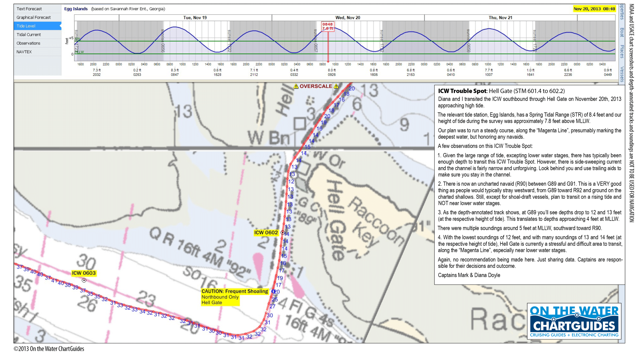
Our good friends, and SSECN strategic partners, Captains Mark and Diana Doyle, founders and owners of “On The Water ChartGuides” (http://www.onthewaterchartguides.com/), give us an updated, graphic report below, relaying what they discovered as they navigated through the AICW Hell Gate Problem Stretch on 11/20/13! Note that the Doyle’s soundings were taken near high tide, so to calculate MLW depths, you must subtract 7.8 feet from their figures. Applying this correction, Diana and Mark noted “multiple soundings around 5 feet at MLLW, southward toward R90.” PERHAPS THE MOST USEFUL PART OF THE DOYLE’S REPORT, IS THEIR DISCOVERY OF A NEW, UNCHARTED MARKER, #90, LOCATED BETWEEN CHARTED MARKERS #89 AND #91! Be sure to observe the new #90 marker as you cruise through! Incidentally, Diana and Mark have recently published a new edition of their immensely popular “ICW CruiseGuide.” Click on the book graphic to the above left for more details, and to place an order!
Hi Claiborne, For those transiting Georgia, Hell Gate has a new, uncharted navaid that should help passage through the shallower sections of this perennial ICW Trouble Spot. I’ve attached a printable high-resolution file of our November 20th survey report and depth-annotated track. Hopefully, SSECN readers cruising this area will find the report useful. Best and hope to see some of the Cruisers’ Net gang at this year’s St. Marys Cruisers Thanksgiving! Captains Mark & Diana Doyle m/v Semi-Local http://www.OnTheWaterChartGuides.com
Just transited Hell’s Gate on 11DEC2013. Delivery of 58′ power vessel with 5’4’³ draft. Passed through at 0620, with tide at approx +2.2. Minimum depth noted was approx. 2.5′ under under running gear. Captain Rob Welling
Our thanks to Captain Mary Dixon, for sending us this good news for cruisers visiting SALTY SOUTHEAST CRUISERS’ NET SPONSOR, Punta Gorda, on Western Florida’s Charlotte Harbor/Peace River.
11/20/2013: The pumpout boat is now operational. To see the schedule and locations, go to: http://www.ci.punta-gorda.fl.us/leis/boating.html Would be a good idea to check with the marina since the schedule may be adjusted based on demand. Mary Dixon
Little Shark River Outer Anchorage - Click for Chartview
Little Shark River is an interesting, but sometimes very buggy anchorage that lies well south of Everglades City and a short hop north of Cape Sable. It is one of the most backwater cruising possibilities in all of Florida. The SSECN recommends three Little Shark River anchorages in our Western Florida Anchorage Directory, but there are actually several dozen spots you might choose to drop the hook. As beautifully described below, Captain Libby chose the Little Shark River Outer Anchorage.
Recently enjoyed a wonderful 2-week cruise from Cape Coral, FL to Boot Key Harbor, Marathon, FL late Oct/early Nov. 2013. Anchored in Little Shark River off Red “4” and it was an incredible experience! Unbelievable fishing, dolphin feeding frenzy, and manatees everywhere enjoying the tidal feast! Offered the most incredible sunsets, brilliant star gazing and sunrises I have ever experienced. Winds were N so I can only guess they blew the mosquitoes away as we were prepared for them and only a few show up on our screens. Tidal swing is strong but a solid holding. Happiest thought I have had in a long time and I look forward to visiting and exploring the area when we have more time. Excellent anchorage if you can bear to be without electronic communication devices! Happy thought for me! Glenda Libby
Anclote Key, Anclote River and the charming community of Tarpon Springs lies astride the northern terminus of the Western Florida ICW. So, this is either the jumping off point when headed north across the waterwayless Big Bend region of Western Florida, or the first possible stop when cruising south from Carrabelle, Dog Island or Apalachicola. Turtle Cove is one of the newest marinas in Tarpon Springs. We had occasion to visit here in February of 2012, and were favorably impressed. Most of the dockage for transient craft is located on an artificial island jutting out into the creek, and connected to the mainland by a narrow, but auto accessible neck. Neat concept! I might also add that all the downtown Tarpon Springs attractions, including the MANY superb Greek style restaurants are within easy walking distance, and there is a fresh seafood market literally next door to Turtle Cove. Yummmmmm! These excellent reports come from our good friends on the Great Loop Forum.
We stayed at Turtle Cove in Tarpon Springs, just after our crossing last January. We agree with every nice thing that’s been said about that marina. I would add that there’s a nice bike path, the Pinellas trail, that you can access not particularly far from the marina, and it goes all the way to Clearwater if I remember correctly (but be REALLY careful about riding in front of a stopped car–it might suddenly decide to take off!!!!!) Also, try Hellas Greek restaurant, and order flaming “oopa” cheese! Tarpon Springs was a fun stop, and the marina handy to all it has to offer. Anita & Don “Limelight”
Let me chime in on Turtle Cove. I found it in a cruising magazine while we were sitting in Steinhatchee. We had been to Tarpon Springs twice before by car and knew that we did not want to stay at the city dock area. There was always too much traffic on the water there so we jumped at the chance to get in a more secluded spot. You have to be careful getting back to it and should holler at a local as you move down the canal off the Anclote River to ask about which side the locals hug. Turtle Cove was a treasure. They have this unique circular island with slips all around. I don’t know if it is manmade or not. We could walk or ride our bikes about two blocks and we were at our all time favorite restaurant “Mama’s Greek Restaurant” where they let us bring our bikes inside because they were worried someone might bother them. Mama’s is on the street behind the main drag. We spent several days at Turtle Cove, ate three times at Mama’s and if I could revisit any marina on the Loop it would be Turtle Cove. Rusty Carlisle


Be the first to comment!