The entrance channel leading to Amelia Island Yacht Basin, A SALTY SOUTHEAST CRUISERS’ NET SPONSOR, cuts into the AICW’s eastern flank, immediately north of the Kingsley Creek Railway Bridge, and just south of Waterway marker #13. Skipper Herl’s report relates a visit before dredging was completed, see /?p=139385
Amelia Island Yacht Basin The crew there is great and the restaurant `The Galley Pub’ was very good. Just stopped in to get a snack but ended up with a huge juicy hamburger and all the fixins. Yum-yum. They are in the process of dredging [now completed] the canal and basin to improve the depth but did not know what the time line would be for completion.
Acosta Creek Marina lies on the east side of the St. Johns River between markers #41 and 42A, south of Seminole Grove, FL. Congratulations to the Simons and we wish them the very best with all their plans.
Recently, Bob and Jane Simons acquired Acosta Creek Marina (formerly Acosta Creek Harbor) in Satsuma Fl. from previous owners James and Cathy Towles. Eager to bring more business into the marina, Jane & Bob have been working hard planning big improvements and repairing facilities that already exist. For those not familiar with the area, Acosta Creek Marina sits approximately an hour and a half south of Jacksonville, two hours north of Orlando, fifty minutes southeast of St Augustine and an hour east of Gainesville all by car. Those of you traveling by water the Acosta Creek Marina is located within close proximity to channel marker 42. The new owners of Acosta Creek Marina have very big plans for their new purchase including expanding many of the marina’s services, as well adding to the goods carried by the ship’s store and improving the grounds about Acosta Creek Marina. Their ultimate goal is to make Acosta Creek Marina not just a stop over or place to store your vessel but a destination on this scenic part of the St. Johns River. They currently offer very affordable dockage at only $7.00 a foot per month with electric on a metered basis and have removed the previous length requirement in order to bring in new customers. Transient dockage is $1.00 a foot daily plus $6.50 for electric. Although Acosta Creek Marina is located in a rural setting, the new owners can arrange transportation for you into town to purchase supplies or check out many of the excellent restaurants in the area. One of their personal favorite dining establishments is Hawg Wash BBQ, with authentic excellent smoked barbecue. The marina is equipped with a 25 ton travel lift and a boat yard where you can do-it-yourself or have one of the many skilled contractors work on your vessel for you. The marina features fixed wood piers with finger slips, showers, a laundry facility and a ship’s store that Jane is working hard to improve.
Other amenities on site encompass a full gambit of recreational activities, with cabins, RV spots, picnic tables, and the soon to be installed horseshoe pits and grills. Some of the best bass fishing in the world is located within in a couple minutes of Acosta Creek Marina and the beautiful crystal clear freshwater springs are located only a short beautiful cruise away.
Georgetown Marina and Lodge lies north of marker #72, a short hop north of the St. Johns River’s northerly intersection with Lake George.Our thanks to Skipper Herl for this report.
Georgetown Marina, Lake George, Florida Georgetown Marina, located at the very north end of Lake George. We originally thought about getting fuel there but they were having trouble with their pumps and they were running really slow. George Town is a nice quiet little fish camp type of marina. The people are very friendly and helpful. Since it is at the very north end of the lake, it can be a bit lumpy if the wind is out of the south. There are not a lot of stores or restaurants within walking distance, so it is probably only for one night stops. We wanted to stop in Lake George and take the dingy into Silver Glen Springs, but the weather did not cooperate. If your ever in the area Silver Glen Springs is one place you should put on the to do list. On weekends it can get really crowded, especially holidays. Phil Herl
Every other year we venture up the St Johns. We always spend one night tied up at Georgetown Marina. Limited dock space and amenities, but the friendliness of the staff make up for that. Their fuel prices are always some of the lowest on the river.
Cocoa Village Marina occupies the mainland side of the Waterway, just north of the Cocoa bridge and only a few quick steps from the downtown Cocoa business district! Our thanks to Skipper Herl for these photos!
Coco Village Marina, Coco, Florida Nice place to stop. Only spent one night. So did not get to do much. A place we would like to spend some time at on the way back home.
When southbound, the Waterway turns southwest into Esterville Minim Creek Canal exiting Winyah Bay at Mile 410.5. The cable operated ferry crossing is now a floating swing bridge crossing at Mile 411.5. Folks who remember Sunset Beach floating bridge fondly (!) will look forward to seeing this apparatus first hand. Our thanks to Skipper Murdoch for these photos.
At St M 411 in place of the Esterville Ferry is new “Floating Swing Bridge” somewhat like the old Sunset Beach Bridge. Here are some pictures taken yesterday. Bill Murdoch
Share:
Comments from Cruisers (2)
Dave Boxmeyer- June 6, 2015 - 10:35 am
Just what we need, a new swing bridge. I remember the Sunset Beach bridge very well. We all held our breath every time they had to open or close it. I had mixed emotions when it was replaced. The Sunset Beach was a piece of history that I thought was lost, now I see it has been reincarnated and the ferry has faded away.
Not to worry… this will never be like the old Sunset Beach pontoon bridge, which opened just once an hour (and took forever!). I talked to the Director at the Tom Yawkey Wildlife Refuge, who told me that they are the only ones who use it, and maybe just a couple times a day at the most. They actually use skiffs to get across most of the time and only use the new bridge if they need to get vehicles or equipment across. So…the bridge will stay pinned to the bank and open to marine traffic almost all of the time. He says they can get the bridge in place and vehicles across in just 4 or 5 minutes, so even if you need to stop, you’ll get to see the pontoon bridge in action without too much delay. A much bigger hazard is the boat ramp next to it…it can get really busy! Mike Ahart Editor, Waterway Guide
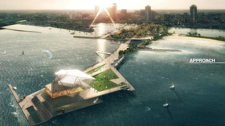
Anyone who has visited St. Petersburg by land or by sea knows this impressive structure jutting into Tampa Bay from downtown St. Pete. It is also adjacent to St. Petersburg Municipal Marina, A SALTY SOUTHEAST CRUISERS’ NET SPONSOR!
St. Petersburg council makes pier pick May 7, 2015, 4:26pm EDT Updated May 7, 2015, 4:36pm EDT Ashley Gurbal Kritzer Tampa Bay Business Journal ROGERS PARTNERS ARCHITECTS+URBAN DESIGNERS; KEN SMITH The Pier Park
At long last, the St. Petersburg Pier is moving toward a new look. The city council voted Thursday to approve the Pier Park design, authorizing Mayor Rick Kriseman to enter negotiations with the design team, ASD/Rogers and Partners/KSLA. Negotiations are slated to take 45 to 60 days.
The Pier Park
The public chose a different concept, known as Destination St. Pier, in an online poll. The city will again seek public input as it works with the design team toward final design, permits and construction. The beleaguered pier has the potential to be an economic driver for St. Pete, the city’s business community says, by creating an attractive gathering spot on the water and creating more foot traffic ‘” and a bigger customer base ‘” for downtown businesses.
Inlet Marina, A SALTY SOUTHEAST CRUISERS’ NET SPONSOR, borders the eastern banks of the Waterway, immediately south of the Vilano Beach high-rise bridge. Skipper Herl adds to the many good things we continue to hear about Inlet Marina and their personal service.
Inlet Marina, Florida Inlet Marina, the friendliest place we have stopped at yet. We talked to Jay about fuel earlier and he told us to come in late PM and we could stay on the dock for the night. So we did. Jay made sure we ate at the restaurant by giving a discount on our meal. The meals were very good. This is a great stop for fuel and grub. We were able to top off with fuel, walk to Publics for groceries. All set for another 500 miles. The tide in that area can be strong, but don’t worry, Jay will let you know the direction and speed when you call for the approach. Like I said up front, Jay is very helpful. Phil Herl
Sailfish Marina of Stuart on Manatee Pocket (not to be confused with Sailfish Marina near Palm Beach and Lake Worth Inlet), is the first facility encountered after entering the Pocket entry passage. Thanks to Skipper Herl for the photos of the popular fishing grounds.
Sailfish Marina, Stuart, Florida Very nice and clean. Because of the spring break we were put on the fuel dock. That was no problem. Everyone was very friendly and helpful. It is a big fishing area so lots of fishing boats in and out. The area is also a no wake zone and everyone pays attention, so it was a pleasant night even on the fuel dock. Phil Herl
SSECN is delighted to let our readers know that the crowd sourced bathometry, ARGUS, accessible on any of our Full Sized ChartView pages, has been updated. Our thanks to engineer John Hersey for supplying this valuable tool to SSECN chart users with just the click of the button found in the top menu of every chart. Try it on the attached chart.
Hi Larry,
Happy spring!!
Just a note to let you know we’ve updated the ARGUS ICW solution set based on about 7 million new soundings processed since the fall update. SSECN readers will benefit from lots of activity in the Florida panhandle between Orange Beach and Cape San Blas, the Florida Keys, the Caribbean, Lake Okeechobee, and the AICW-proper from Norfolk to Florida to include several off-waterway excursions. Look for updates throughout the ICW to include the latest from Hell Gate, Jekyll Creek, the Ashepoo-Coosaw Cutoff, Fields Cut, and the rest of the classic trouble spots. We expect lots of data in the coming months from the dedicated fleet of ARGUS vessels and will be sure to post these updates as well.
Regards, John Hersey SURVICE Engineering 29.82912104147681,-81.30384018787203
Share:
Comments from Cruisers (1)
Bill Hitchcock- July 19, 2015 - 2:17 pm
What lake level are the soundings in Lake okeechobee corrected to, or what lake level were they observed? Since there is no “MLLW” the lake level at observation or correction to the standard lake level is essential. Thanks, Bill
Have you seen one of these? Somehow I think we will not be seeing this vessel on any portion of the Waterway!
Seeing Double?
DYT Loads $350 Million Worth of Superyachts Headed for Med
PORT EVERGLADES, FLA. (May 29, 2015) ‘“ In a rare occurrence last week, DYT Yacht Transport‘s two semi-submersible ships pulled into Port Everglades (Ft. Lauderdale, Fla.) simultaneously to load $350 million worth of yachts bound for the Mediterranean Sea. With busy sailing schedules to worldwide destinations, it is unusual for the 556-foot M/V Super Servant 4 and the 686-foot M/V Yacht Express to be seen in close proximity to each other, much less in the same port doubling up on the fascinating process by which they float private luxury yachts into their cargo bays.
`Fort Lauderdale has been the western hemisphere’s home base for operations in the yachting industry for decades,’ said DYT’s Jeff Last,’ and it is here where yachts, small and large, spend time between busy charter seasons. April thru June are the prime time for yachts to take the journey across the pond in order to reach the Mediterranean’s cruising grounds in time for peak season.’
Photo credit: Joseph Hoyt
This special DYT double shipment includes a total of 39 yachts with lengths ranging from 30-200 feet. The two fully-loaded ships left Port Everglades on May 22nd and are scheduled for drop-offs in Genoa, Italy, Taranto, Italy, and Palma De Mallorca, Spain during the second week of June.
M/V Super Servant 4 and M/V Yacht Express are the only semi-submersible vessels in the world specifically engineered for yacht transportation. These unique vessels submerge, transforming into a marina where professional yacht captains and crew are able to dock their owners’ prized possessions safely and with no hassle. DYT then de-ballasts the vessel to have the yachts rest on secured supports, effectively allowing for transportation of the yachts while on a floating dry-dock complete with power and water hookups. The `float-on’ process is then reversed for an equally safe `float-off’ delivery of the yachts at their desired destinations.
Since 1987, DYT Yacht Transport, based in Fort Lauderdale and a member of the Dutch shipping company Spliethoff Group, has delivered over 13,150 motor and sailing yachts to various destinations around the globe.
For an up-to-date sailing schedule and to request a quote, please visit www.yacht-transport.com.


Be the first to comment!