There is always plenty to do around Charlotte Harbor! While berthed at Fishermen’s Village Marina, A CRUISERS NET SPONSOR, you are certain to enjoy visiting Western Florida’s beautiful Charlotte Harbor/Peace River.
Harbour Town Yacht Basin, A CRUISERS NET SPONSOR, is ready for your reservation with newly renovated docks, upgraded electrical service and onSpot WiFi, also a CRUISERS NET SPONSOR. And, as always, numerous activities at the Sea Pines Resort are offered for your enjoyment, as you will see in the Event Schedule below. Hilton Head Island is absolutely marvelous any time of year.
June is the beginning of the summer season in South Carolina with the summer solstice happening on June 21st. The summer solstice marks the longest day, or hours of sunlight during a day, that the Northern Hemisphere will receive in the year. The exact number of hours experienced will depend on the viewer’s exact location, but if you are located within South Carolina you should expect to have just over 14 hours of daylight from sunup to sundown.
We will get to observe some thrilling and exciting changes in wildlife activity this month. Aves, or birds, are active during this time of year. Along the coast, shorebirds may be seen sitting on nests. In places like Botany Bay Heritage Preserve, it may be possible to spot an American oystercatcher in the distance by scanning the dunes for its bright orange beak. Nesting areas may be marked by similarly-colored bright orange tape. Observing shorebirds from a distance, especially during nesting season, is encouraged. This time of year, species like brown pelicans, royal terns, sandwich terns, least terns, black skimmers, and American oystercatchers are settling down atop their nests. These nesting colonies will often be behind some type of barrier where they are being protected as well as monitored by scientists. To get a closer look, I would recommend a good pair of 10 x 42 binoculars or your favorite camera, or even phone with a zoom lens attached. Report your findings to iNaturalist or eBird as well to contribute valuable citizen science data! Maybe if you find a passion in reporting birds you can become one of the famous “listers” — a person who meticulously reports and seeks out different species of birds, or maybe you might find a new “lifer” — or a bird seen by you for the first time in your life.
Nature photography day is June 15th! This day was created by the North American Nature Photography association and highlights the importance of photos in telling a conservation story and in research, as well as the value of it as a nature-based activity that can be enjoyed but all people, equipment and skill level aside. Get outside and explore a new public land, with a camera of any type in hand.
Red-winged blackbird, Photo by Allison DeVore
A note from Allison DeVore SCDNR Photographer and Videographer. “Every shoot brings something new, whether that’s a species I’ve never encountered or a person I’ve never met, and that’s what keeps it interesting. I love getting to tell the stories of SCDNR.” The photo of the red-winged blackbird was taken at Donnelley WMA and is one of Allison’s favorite photos that she has taken.
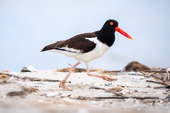
American Oystercatcher
American Oystercatcher, Photo by Kaitlyn Hackathorn
The American Oystercatcher (Haematopus palliatus), found in South Carolina, is a shorebird species with a remarkable conservation success story. In 2008, the U.S. Atlantic and Gulf coast’s population estimate was 10,000 individuals. Surveys in 2023 counted 14,000 oystercatchers, an increase of 43 percent! As its name suggests, the American oystercatcher primarily feeds on oysters, mussels, clams and other marine invertebrates. Its bill, that is shaped like an oyster knife, allows it to access food sources unavailable to many other shorebirds that lack this specialized oyster opening adaptation. Habitat loss and alteration have long been major challenges for the species. American oystercatchers show strong site fidelity, often returning to the same nesting beach season after season, despite changes to those habitats over time. Conservation efforts that have contributed to the species’ recovery include habitat management for invasive species, restrictions on disturbance from domestic pets, protective buffers around nesting sites, and the creation and restoration of oyster reefs. This recovery effort has been a collaborative initiative involving state agencies, nonprofit organizations, and individuals along the Atlantic and Gulf coasts. Although the population has increased, the species still faces ongoing threats such as storms, nest disturbance, and beach erosion and loss. The story of the American oystercatcher, like that of South Carolina’s wildlife as a whole, remains an ongoing one that requires continued attention, collaboration, and support from both environmental institutions and the public.
Looking for a fun activity geared toward kids or a school group? Learn how to make a pinhole camera!
Deveaux Bank Seabird Sanctuary
Deveaux Bank, Photo by Kaitlyn Hackathorn
Please be aware that The S.C. Department of Natural Resources’ (SCDNR) Deveaux Bank Seabird Sanctuary is completely closed March 15-October 15 to protect coastal birds during the nesting season.
Deveaux Bank Seabird Sanctuary was established to protect significant nesting habitat of sea and shorebirds. Located at the mouth of the North Edisto River in Charleston County, Deveaux Bank Seabird Sanctuary encompasses approximately 215 acres of sandy beaches, vegetated dunes, broad marshes and intertidal shoals. The size of this sanctuary varies, and it may sometimes disappear entirely. The location of Deveaux Bank as an estuarine island was first documented in 1921, and it was documented as a seabird rookery in the 1930s. During World War II, nesting was temporarily interrupted due to the island’s use as a bombing range. Deveaux Bank is part of a dynamic system; it completely subsided in 1980 due to erosion from Hurricane David and then slowly reemerged to provide seabird nesting habitat again in 1983.
Deveaux Bank’s maritime grassland community lives on unstable sand dunes elevated above the highest flood mark. The grassland community is dominated by Russian thistle and marsh hay, which grow along with camphorweed, beach elder, beach tea and dog fennel.
Deveaux Bank supports colonies of nesting waterbirds because of its isolated nature and lack of mammalian predators. Although all species may not nest on the island each year, examples of species that have used the island include brown pelican, least tern, royal tern, black skimmer, gull-billed tern, sandwich tern, common tern, laughing gull, Wilson’s plover, American oystercatcher, willet, great egret, snowy egret, tricolored heron and white ibis.
The colonial nesting behavior of these birds makes them very susceptible to disturbance. Birds are densely packed into breeding sites during the nesting season, rendering the entire rookery susceptible to disruption or destruction. In addition, migratory and wintering shorebirds and seabirds need periods of rest and foraging free from disturbance to survive long journeys and inclement weather. The sand flats and mud flats located in the interior of the island provide feeding and loafing habitat for numerous shorebird species including red knot (federally threatened), piping plover (federally threatened), sanderling, dunlin, short-billed dowitcher, marbled godwits and many others.
In recent years, Deveaux Bank made national headlines as SCDNR biologists discovered the largest known concentration of Hudsonian whimbrels, a rare curlew species, using the site as a nocturnal roost on their spring migration. Due to its critical importance for whimbrels, as well as other migrating shorebirds, Deveaux Bank was designated as a Western Hemisphere Shorebird Reserve Network site of international importance in 2024.
SCDNR events often require pre-registration to attend. Please click on the respective links and ensure you are signed up before attending.
Saltwater Fishing Clinics
Many dates and locations are available this month!
These clinics will teach you how to tie knots, rig your rod, how to cast, what bait to use, and what fish you can catch in saltwater! Find all dates and other events at the SCDNR Fishing Outreach Eventbrite.
Freshwater Fishing Clinics
Many dates and locations are available this month!
These clinics will teach you how to tie knots, rig your rod, how to cast, what bait to use, and what fish you can catch in freshwater! Find all dates and other events at the SCDNR Aquatic Education Eventbrite.
Ironclad Anglers Fishing Rodeo, Colonial Lake, Charleston County
Saturday, June 6th, 8:30 a.m. to 11:30 a.m.
Come join SCDNR and the City of Charleston for a hero-themed saltwater fishing rodeo at Colonial Lake. Youth 15 and under. Register here
Hikes with a Naturalist, Ashmore HP & WMA, Greenville County
Saturday, June 20th, 8:00 a.m. to 11:00 a.m.
Hikes with a Naturalist are introductory explorations into the natural world around us. These hikes will cover topics ranging from local wildlife and fishes to best hiking practices and land management. Register here
Red Snapper 101- Charleston County
Monday, June 29th, 6:00 p.m. to 8:00 p.m.
Red Snapper 101 will be taught by SCDNR staff, fishing professionals, and Shimano staff. We will go over the new updates, fish ID, and more.
The Red Snapper class goes over the new regulations, reporting system, season, fishing techniques, and fish ID. This class will teach you everything you would want to know about red snapper. Kids from ages 6 to adults are welcome, so come out to Shimano’s classroom and enjoy the class! Register here
About Us:
Conservation Education is a section within SCDNR’s Office of Education, Outreach, and Information. Our goal is to connect South Carolinians and visitors to public lands to help them live life outdoors. Our educational programs offer lessons on wildlife, fisheries, forestry, land management, watersheds, and environmental history.
This swim event will be north of the Waterway’s path through Charleston Harbor. More information about the event can be found at https://lowcountrysplash.com/.
Good afternoon Charleston HSC,
Please find attached the MSIB for the upcoming Lowcountry Splash. The event information is as follows:
The annual Lowcountry Splash open water swim event will take place in Charleston Harbor on Saturday, June 13, 2026, from 7:30 a.m. until 10 a.m. The 6-mile swim will start under the Wando River Bridge on Daniel Island, cross the Wando River near Hobcaw Yacht Club, and will finish at the Charleston Harbor Resort & Marina. The 2.4-mile swim will start at Hobcaw Yacht Club, continue along the Mount Pleasant side of the Wando River and finish at the Charleston Harbor Resort & Marina.
A special local regulation, established in 33 CFR 100.704, Table 1, Item No. 4, will be in effect for a moving safety zone. This safety zone will encompass all waters surrounding event participants and safety vessels extending 50-yards in front and behind, and 100-yards on either side. No one shall enter, transit, moor, anchor, or remain within the safety zone unless specifically authorized by official event patrol. Mariners can anticipate the swimmers crossing the channel on the Wando River between 7:45 a.m. and 8:45 a.m. All mariners are urged to use caution while transiting the area and should coordinate with on-scene safety boats via VHF channels 16. When hailed or signaled by on-scene safety boats, all vessels in the immediate vicinity of these racing zones shall comply with directions given.
Very respectfully,
LT Nicholas Jones WWM Division Chief USCG Sector Charleston Nicholas.J.Jones@uscg.mil O: 843-740-3184 C: 843-323-7761
Along with boatowners who are diligent about SPARRING WITH MOTHER NATURE and her amazing ability to deteriorate, there are dozens of derelict, abandoned vessels in this particular boatyard, one of thousands worldwide. If you wander about and contemplate the peeling coatings, rusted metal, sunken jackstands, and tattered coverings, you can feel the neglect, black mold covers interior surfaces and the exterior cracks and dries in penetrating sun, you know they will never again touch the water. We call it DEATH ROW.
The bright green one in the middle may launch again…others? Well, no.
All shapes & sizes to be pondered, revered and pitied.
Here at Yacht Maintenance Company, Cambridge, Maryland, the most notable and most fascinating, are in the row closest to the boatyard entrance, farthest from the water, appropriately enough. They sit perched on the highest point of land around, six now-decrepit vessels who, in their glory days, were glorious indeed. Places of celebration and joy, rest and recuperation, indulgence and intrigue, prestige and prosperity. Well-tended and well-loved, for certain. How, I ask myself, did all these souls end up here, on a long, winding river off the swampy eastern side of the Chesapeake Bay? A boat is internationally required to have both a name and a Hailing Port conspicuously posted to indicate where she originated, and if cleverly captured, what she personified. Sometimes you can then guess at a tiny part of her history, and the imagination can run quite wild. This gold-embossed, hand-carved name plate, though faded, catches the eye.
I had to look this one up…BACCHANTE(Google) “‘a woman who completely lets loose and enjoys partying with wild abandon.’ Some luxuries still intact…
MAESTRA of Washinton, DC really makes you wonder. This vessel is a Baglietto, “…historic and highly prestigious Italian luxury shipyard opened in 1854…” This is a 16M, they now start at 26M and go to 80+. *
UNSUSTAINED DREAMS. Or shall I say UNSUSTAINABLE, or UNTENABLE? Except to a very small percentage of individuals who have the means and the desire. These vessels have a life span; we’ve talked about the biodegradability of wood, the rusting of iron, the insidious leaks that start anywhere and then catch sailors dangerously unaware, the corrosive nature of aluminum when it touches salt water. The volatility.
There are an assortment of reasons, of course, that these vessels were simply abandoned. We never want to underestimate the pure power of money or how it is spent, but let’s face it, many probably come down to finances. the bigger your hobby the more of a commitment it becomes; financially, emotionally, personally, and time, oh, that bandit time. Time and Mother Nature are allies, hand-in-hand, skipping down the slippery-ass boat ramp of life encrusted with the ordinary and the unexpected, the soft and the slicing. Hard to defeat. Harder to estimate. The leaving behind happens on the water, too, and has caused a ruckus about anchoring and timing and living aboard in places that liveaboard Cruisers used to be welcome. One bad apple…
This society is far from perfect and we all make our choices. Some of those choices are most certainly what we leave behind.
In a perfect world, our piece of history named STEADFAST would be welcome and revered rather than devalued. I understand how disheartening it can be to keep investing in something that does not gain value except to oneself. I love my old wooden girl, but there is always something else that needs investment of time and resources. To possess something that other people cannot relate to, insurance companies won’t insure and fancy new marinas won’t let dock is a difficult thing indeed. If and when one does take the resisted path, it can be messy. I’ve wandered down a fun and shit-strewn trail for years and it made me better, frankly. Stronger, faster, smarter (like a superhero but NOT AT ALL like a superhero).
How you dispose of what you no longer want, in that ideal scenario, should not become someone else’s problem.
MIST OF AVALON, a unique blue-water wooden schooner from Nova Scotia, Canada, was a well-recognized tall ship at Canadian and US festivals as recently as 2018. She was undergoing refit during COVID and when the crew was finally allowed to leave, the story goes that they never returned. Her two massive steel spars were removed just a few weeks ago, the pile of lines and rigging amounting to almost a dump truck load in itself. There is a sadness that emanates now, from that hull. Occasionally, she sinks beneath the surface of her slip and, uncompensated, the boatyard crew pumps her out yet again, wary to spend the resources to dispose of her properly. Boats that are cleaned and become underwater reefs are most certainly a brilliant idea, but that, too, takes resources, permissions, and time.
31M MIST OF AVALON of Nova Scotia met her demise here when she was abandoned in 2021. Our innovative and fearless Boatyard Manager (on lift) overcomes another challenge as her masts are removed; hull, interior remain afloat.
Have you been forced to or chosen to leave something behind that became someone else’s burden? We probably all have. Let’s hope our dreams don’t end up on DEATH ROW. Until next week I plan to dream big regardless. — ~J
Substack keeps me up past my bedtime every Saturday night and it’s a mission that I love, to create something that you can enjoy, learn from and consider. If you think it’s share-able, please pass it along via traditional methods or the re-stack button. THX!
Perhaps we are secretly (or not) at the helm of something similar to this working girl?
We remain in a tranquil weather pattern across the Atlantic tropics for now. We have a disturbance in the Gulf that won’t develop before moving into Louisiana, but will bring some rain to the lower and middle Mississippi Valley this weekend. We also have four tropical waves to track. One is over the Caribbean Sea and Colombia (along 75° west), one is near the Lesser Antilles (at 60° west), and the other two are over the tropical Atlantic (near 53° west and near 27° west).
A loop of visible satellite imagery showing the features of interest across the Atlantic tropics. A storm centered northeast of Bermuda will not turn into a tropical cyclone as it moves eastward across the Atlantic.
Image Source: University of Wisconsin RealEarth
The Madden-Julian Oscillation is favorable for tropical cyclone formation over the Atlantic. However, other factors, such as widespread strong vertical wind shear (blame the developing El Niño in the Pacific for that), make further development in the Atlantic unlikely over the next seven days.
Starting about a week from now, the shear may relax enough over the western Caribbean Sea and Gulf that one of the waves now drifting westward over the tropical Atlantic has a chance to develop further once it reaches the area. It’s also possible that a Central American Gyre forms, and we get a development from that, or that the gyre and a tropical wave come together and spawn a tropical cyclone. Everyone’s favorite computer model, “The Euro”, has jumped on the bandwagon of showing a possible development around mid-month. However, it can only be said at this time that development is a reasonable possibility in a week or so. Until a storm develops or we’re sure one is imminent, we can’t say whether South Carolina will be affected.
This is output from the ECMWF Ensemble model indicating the percent chance for a tropical cyclone to be within 300 kilometers (about 186 miles) of a point on the map through the 15-day model run (starting at 8 p.m. Thursday EDT). It gives a user an idea of where tropical cyclones could form and track over the next 15 days. It does not indicate how strong a potential storm could be.
Image Source: WeatherBELL
An alternate scenario is that one of the storms we’ll see develop in the far East Pacific might cross Central America into the Atlantic in a week or so. That’s rare but not unheard of.
The bottom line is that you should be sure you’re ready for anything the hurricane season might throw at you. There’s a chance we’ll have to deal with a storm sooner rather than later. So, get those hurricane kits stocked and have your plan ready. As always, your best source for preparedness information is hurricane.sc.
South Carolina weather highlights for the next week:
High pressure currently overhead keeps us warm to hot and rain-free through this weekend. Humidity will increase as the high shifts eastward and the wind becomes southeasterly. Highs will be mainly in the upper 80s to lower 90s on Saturday, then mainly in the low- to-mid 90s on Sunday.
Along comes a ‘backdoor front’ (moving in from the northeast) on Monday, which will likely become stationary over South Carolina into Tuesday. That will generate mainly afternoon and evening showers and thunderstorms, which could be spotty. That will ease the heat somewhat, with highs mainly in the upper 80s to lower 90s on Monday, then mid-to-upper 80s on Tuesday.
The front retreats northward after that, putting us in a hot and humid air mass for the end of next week. Afternoon thunderstorms can’t be ruled out, but will be isolated and mainly confined to the Upstate and Coastal Plain. Highs trend up to the low 90s for most of the state by Thursday.
Early signs suggest it could be quite hot next Friday and next weekend, with some 95°+ temperatures possible for our state’s usual hot spots.
Frank Strait Severe Weather Liaison S.C. State Climate Office
South Carolina Department of Natural Resources 260 D. Epting Lane West Columbia, SC, 29172
Atlantic Yacht Basin, A LONG-TIME CRUISERS NET SPONSOR, is located just south of the Great Bridge lock and bridge at Mile Marker 12 in Great Bridge, VA. If you have wood damage or need a few modifications with the interior or exterior of your boat, Atlantic Yacht Basin has the team to fix it right.
I have used them many times for both repairs and short-term storage during my ICW trips. AYB has a great location and is capable of performing any repairs you may require.


 American Oystercatcher, Photo by Kaitlyn Hackathorn
 Looking for a fun activity geared toward kids or a school group? Learn how to

 SCDNR events often require pre-registration to attend. Please click on the respective links and ensure you are signed up before attending.


Be the first to comment!