CRUISERS NET
Cruisers Helping Cruisers
Comprehensive cruising resource for the Intracoastal Waterways
from Norfolk to the Northern Gulf and Bahamas.
from Norfolk to the Northern Gulf and Bahamas.
FREE to use due to the generosity of our sponsors - please patronize them
Is the Atlantic Shifting Gears? – Fred Pickhardt
Fred Pickhardt’s Substack is free today. But if you enjoyed this post, you can tell Fred Pickhardt’s Substack that their writing is valuable by pledging a future subscription. You won’t be charged unless they enable payments.
 Forwarded this email? Subscribe here for more
For the first time in over 30 years, we are seeing evidence that the Atlantic Multidecadal Oscillation (AMO) might be heading into its negative (cool) phase. If this shift is real, it could fundamentally change our weather patterns for the next two decades.
The “Horseshoe” Emerges
The hallmark of a negative AMO is a distinct “C-shaped” or horseshoe pattern of cool water stretching across the North Atlantic. Looking at current sea surface temperature (SST) anomalies, we are seeing exactly that: a crescent of cooler water running from the UK down to the Canary Islands, paired with a persistent cold pool south of Greenland.
The cold “blob” south of Greenland is particularly telling. It’s often noted as a byproduct of a slowing AMOC (the ocean’s “conveyor belt”) and is also closely linked to a negative phase of the Atlantic Multidecadal Oscillation (AMO).
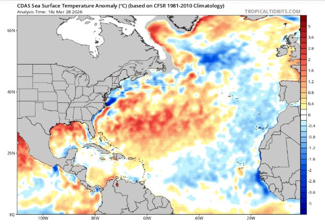
North Atlantic SST Anomaly (topicaltidbits.com)
A Cooling Tropical Atlantic
The biggest hurdle for a negative AMO phase recently has been the Atlantic Main Development Region (MDR). In recent years, the tropics have remained stubbornly warm. However, as of March 2026, we are seeing widespread neutral to cool anomalies in the MDR. This makes the case for a phase shift significantly stronger than it was just twelve months ago.
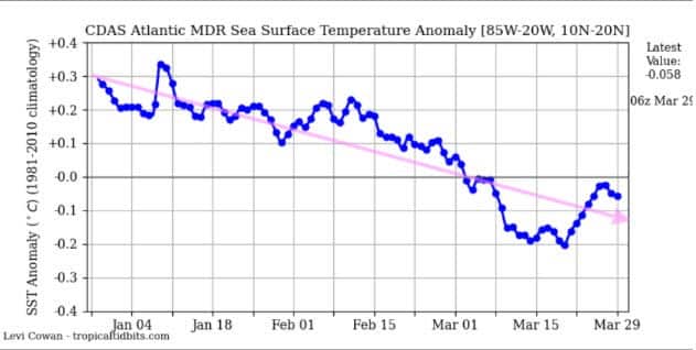
Atlantic MDR SST Anomaly (Tropicaltidbits.com)
Real Shift or False Start?
The AMO is a marathon, not a sprint. History is full of “false starts” where the ocean cools for a year or two before the warm cycle resumes. Current cooling in the eastern Atlantic could simply be a temporary reaction to atmospheric triggers, like a strong Positive North Atlantic Oscillation (NAO) phase. To confirm a true regime shift, these cool anomalies need to persist and expand for several consecutive years. We aren’t ready to declare the “Warm Era” over just yet, but the needle is moving.
What This Means for the Future
If this pattern holds through the 2026 hurricane season and into 2027, the implications are significant. A sustained negative AMO phase typically brings:
- Quieter Hurricane Seasons: Cooler water in the MDR means less fuel for storms and generally higher wind shear, which rips systems apart.
- Rainfall Shifts: We could see a return to drier conditions in the African Sahel.
- European Weather: A shifting jet stream often translates to cooler, wetter summers for parts of Europe.
We are watching the Atlantic closely. If the 1995–2025 warm cycle is indeed ending, the next 20 years of weather will look different from the last.
You’re currently a free subscriber to Fred Pickhardt’s Substack. For the full experience, upgrade your subscription.


© 2026 Fred Pickhardt
548 Market Street PMB 72296, San Francisco, CA 94104
Unsubscribe

Be the first to comment!
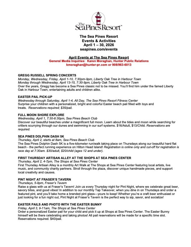
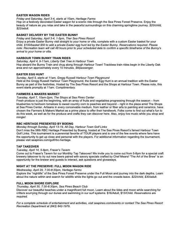
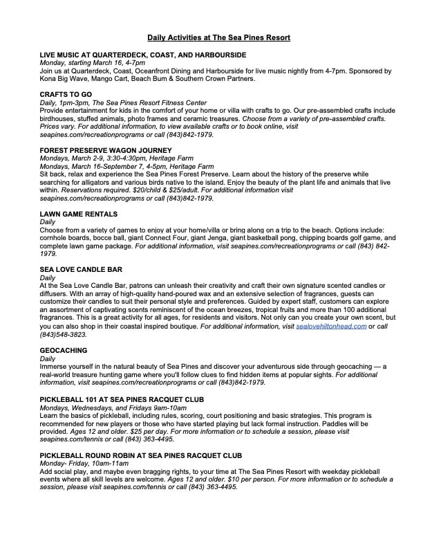
What’s Happening At the Sea Pines Resort (April 2026), Harbour Town Yacht Basin, SC AICW MM 565

Harbour Town Yacht Basin, A CRUISERS NET SPONSOR, is ready for your reservation with newly renovated docks, upgraded electrical service and onSpot WiFi, also a CRUISERS NET SPONSOR. And, as always, numerous activities at the Sea Pines Resort are offered for your enjoyment, as you will see in the Event Schedule below. Hilton Head Island is absolutely marvelous any time of year.

Kerry Maveus
kmaveus@hunter-pr.com | www.hunter-pr.com
mobile: 831-917-2878
P.O. Box 1049 | Pebble Beach, CA | 93953
Be the first to comment!
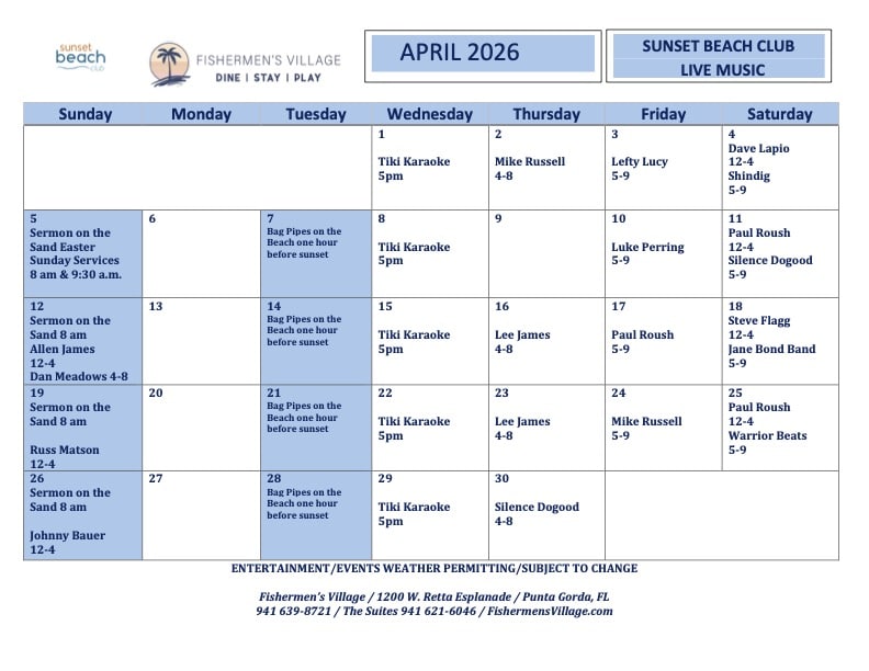
Fishermen’s Village April 2026 Calendars, Punta Gorda, FL

There is always plenty to do around Charlotte Harbor. While berthed at Fishermen’s Village Marina, A CRUISERS NET SPONSOR, you are certain to enjoy visiting Western Florida’s beautiful Charlotte Harbor/Peace River.
Fishermen’s Village APRIL Calendars of Entertainment/Events
April 2026 Sunset Beach Club Calendar

Special Events & Community Relations941.639.8721
Click Here To View the Western Florida Cruisers Net Marina Directory Listing For Fishermen’s Village
Click Here To Open A Chart View Window Zoomed To the Location of Fishermen’s Village
Be the first to comment!
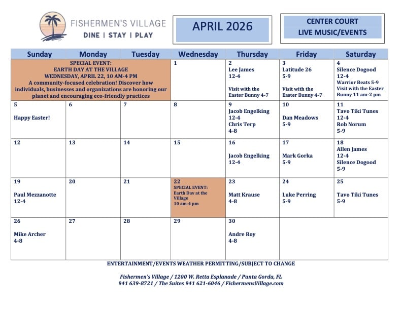
Fishermen’s Village April 2026 Calendars, Punta Gorda, FL
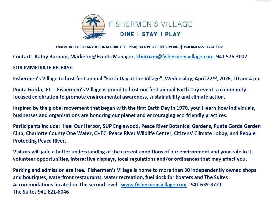
There is always plenty to do around Charlotte Harbor. While berthed at Fishermen’s Village Marina, A CRUISERS NET SPONSOR, you are certain to enjoy visiting Western Florida’s beautiful Charlotte Harbor/Peace River. Please consider visiting Fishermen’s Village first annual “Earth Day at the Village” event, scheduled for Wednesday, April 22nd, 2026, 10am-4 pm.
Screenshot
Special Events & Community Relations941.639.8721
Click Here To View the Western Florida Cruisers Net Marina Directory Listing For Fishermen’s Village
Click Here To Open A Chart View Window Zoomed To the Location of Fishermen’s Village

Be the first to comment!
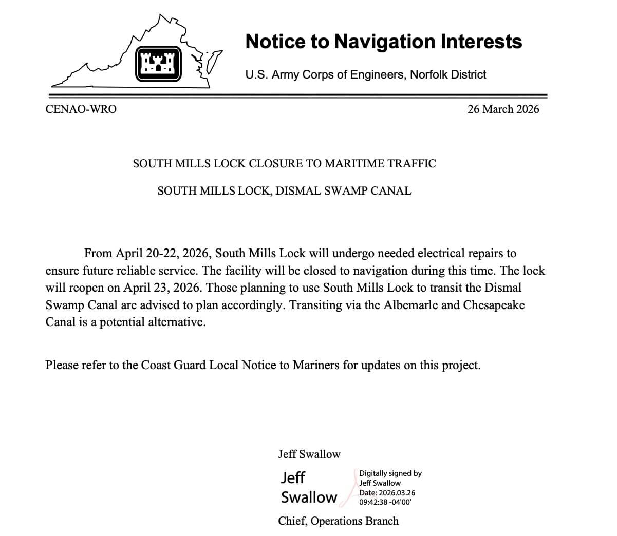
South Mills Lock Closure – April 20-22, Dismal Swamp Canal, AICW Alternate Route
Scheduled closure of the South Mills Lock for electrical repairs on April 20-22, 2026. Our thanks to Sarah Hill of the Dismal Swamp Welcome Center for this information.
Please see the USACE Norfolk District’s Notice to Navigation regarding the scheduled closure of the South Mills Lock on the Dismal Swamp Canal, April 20-22, 2026. This temporary closure is for electrical repairs to be made. The lock will reopen on April 23, 2026.
Attaching image from this week at the dock. Boaters are beginning to trickle through during this early springtime period.
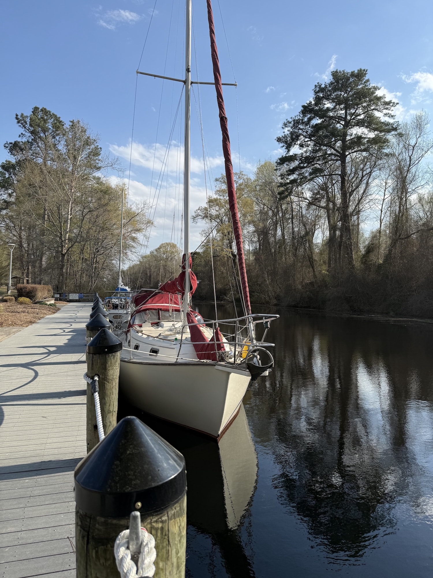
Looking forward to many more in this season!
Thanks,
Sarah
Sarah Hill, TMP
Director, Dismal Swamp Canal Welcome Center
Chairperson, Camden County Tourism Development Authority
2356 US Hwy 17 North, South Mills, NC 27976252-771-8333 | shill@camdencountync.gov www.DismalSwampWelcomeCenter.com ___________________________________________________________
Click Here To Open A Chart View Window Zoomed To the Location of South Mills Lock
Click Here To View the North Carolina Cruisers’ Net Bridge Directory Listing For South Mills Lock
Be the first to comment!
O DRAG – Janice Anne Wheeler, Sparring With Mother Nature
TO DRAG
Or Not To Drag
Anchors. We’re talking anchors!
This week flew by with final edits, acoustic guitars, sketches of anchor systems and calls to Port Townsend Foundry in Washington State, one of the only remaining forges in the US. They create stunning, creative, powerful bronze vessel hardware, you can view their work here. We haven’t come to a consensus yet, but are confidant that owner Pete Langley has the talent and skill that we need to build the new, larger, system that we require. Their reputation is impeccable and the reason we chose to go to this level of quality and expenditure is because, as mentioned last week, it is very important to stay where you want to be on a vessel, especially if it is anywhere near land, shallow water or other obstacles, often other boats. The mariner’s term for this essential holding equipment is ground tackle.
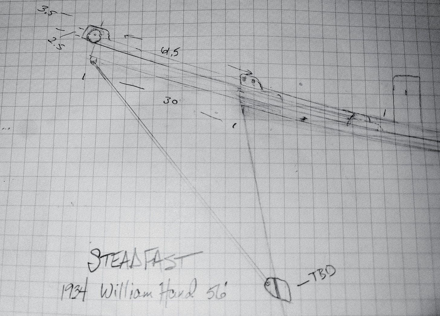
The vision, the plan. Since I received more than a few comments on this topic, I decided to link a story, originally entitled DRAGGING (modified to Eclipse Interrupted by the Editor), published in SAIL magazine, 2024. Since these sort of events seem to always happen at night, this truly depicts the heart-pounding terror that grips a sailor and crew when an anchor is no longer doing what it should. You feel like your hair is on fire. All hell has broken loose along with your ground tackle. Looking back and reliving the moment, I hope it conjures a dose of adrenaline and a dose of our reality; dragging an anchor really is bolt-upright-in-bed scary stuff with the potential for both danger and destruction. It’s the reason STEADFAST is upgrading the size of the anchor as well as its deployment and retrieval system.
Between what can happen when we’re on the water and what we have had to do to get back in the water, it’s no wonder friends far and wide are convinced we’re batshit crazy. I know that description still stands, and is probably as accurate as it could be.
What I also know is that it’s quite a unifying, satisfying feeling to be passionate enough about something to put our lives, savings, souls and energies into it.
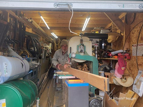
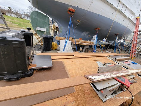
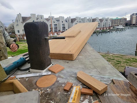
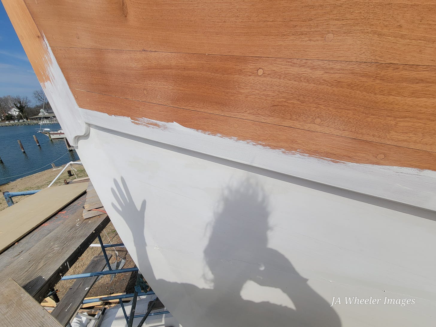
We are engineering, thinking, consulting, sanding, priming, painting and preparing for this crucial install. Here are our workspaces:
Every day there’s a multitude of projects. Right now SPARRING WITH MOTHER NATURE is mainly the weather—from 74 to 24(F) with an occasional downpour and north winds that chill to the bone…no complaints because some of this nation has had it much worse and our hearts are with them.
As always, thanks for being aboard. There’s nothing quite like STEADFAST, and nothing quite as dedicated as you, if you’ve gotten this far. I cannot tell you how much I appreciate it—-makes the whole project so much better when I can share it with the world. Wooden boats may or may not have been a topic that you would have chosen, so just remember, this mountain and desert dweller never imagined herself here, hauling anchors and meeting the eyes of dolphins. LIfe is good, if unpredictable.
All the best to you and what you are passionate about, whether it makes sense to everyone else or not! See you here next week. ~J
Hair is definitely on fire. Thanks to SAIL magazine, I appreciated their publishing my work, here is the link:
https://sailmagazine.com/cruising/cruising-eclipse-interrupted/
Serious cruiser use anchor alarms for a reason! Sailing Vessel Roam’s Substack is interesting in regard to utilizing three alarms set simultaneously. They are currently on the other side of the planet; if you’re interested take a look, Jim is quite an informative writer!
Be the first to comment!


Social Media Auto Publish Powered By : XYZScripts.com
Be the first to comment!