Arthur’s remnants will bring a risk for locally damaging wind, isolated tornadoes and flooding rain to South Carolina tonight.
The damaging wind and tornado risk is greatest over the area between I-20 and I-85, and minor wind damage could be widespread in this area. However, a risk will be present over the entire state.
The risk of flooding rain is greatest over the northwestern quadrant of the state, but isolated flash flooding is possible elsewhere.
Behind the storm, the weekend is looking mainly rain-free, except for a chance for a shower and thunderstorm over the southern Lowcountry Saturday and stray afternoon thunderstorms over the Upstate on Sunday.
Arthur’s remnants, at press time centered close to Phil Robertson’s backyard, are heading east-northeastward and will cross South Carolina tonight and early Friday. Flooding rain, strong winds and isolated tornadoes are all threats as it moves through.
A loop of visible satellite imagery shows a big blob of clouds tracking eastward over the Southeast associated with the remnants of Arthur.
Image Source: University of Wisconsin RealEarth
Ahead of Arthur, a weak warm front will trigger showers and thunderstorms this afternoon and evening in the soupy air mass present over the Palmetto State. Stronger storms can cause locally damaging winds. Hail and tornado risks will be minimal through early evening with these thunderstorms.
MRMS weather radar composite shows thunderstorms affecting the Coastal Plain and more storms moving in from Georgia.
Image Source: WeatherBELL
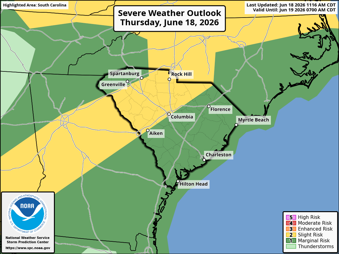
Arthur’s remnants will arrive over the western Upstate this evening and rake across the state through the night and exit offshore by around 10 a.m. Friday. There remains some uncertainty about where the heaviest rain will fall, which areas will be hit by the strongest winds, and which areas will be subject to a tornado threat. The expected storm track has shifted slightly northward today, bringing the zone of greatest concern for damaging wind and tornadoes to areas along and between I-20 and I-85.
The Storm Prediction Center’s Day 1 (through tonight) Severe Weather Outlook graphic for South Carolina has the entire state covered with a band of level 2 of 5 between I-20 and I-85 due to an elevated tornado and wind risk for that area.
The risk of excessive rainfall and resulting flash flooding covers the entire state, but the quadrant roughly between I-20 and I-77 is at greatest risk.
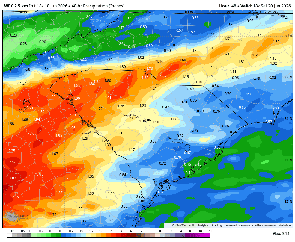
Rainfall over the Upstate and vicinity through early Saturday will generally be 1-3 inches, with local totals of 4-5 inches. The I-20 Corridor is looking at 1-2 inches, locally up to 3 inches. Over the Coastal Plain, the forecast is for generally half an inch to an inch; locally, up to 2 inches is possible. This will put another nice dent in our drought, especially in the Upstate.
The rainfall forecast from the Weather Prediction Center for now through 2 p.m. Saturday shows a major soaking over the Upstate and vicinity.
Image Source: WeatherBELL
Behind Arthur, a cold front will move through later Friday into Friday evening. It will trigger scattered showers and thunderstorms; a locally severe storm with damaging wind can’t be ruled out.
Behind all this mess, Saturday looks to be a nice day for most of the state for mid-June with lower humidity. The exception will be the southernmost part of the state; the cold front turns stationary over or just south of the Lowcountry, so that area has a chance of showers or thunderstorms. Sunday looks hotter and more humid with a pop-up thunderstorm possible over the Upstate — more typical summer weather for the start of astronomical summer (summer starts June 1 in every meteorologist’s mind) and Father’s Day.
Get ready for impacts tonight by reviewing severe storm and tornado safety tips and flooding safety tips. A tornado threat coming in the middle of the night is always problematic; be sure you have multiple ways to receive warnings that will wake you up.
Again, think of this as a tropical warning shot; take some time to get your hurricane prep work done. If you need help with that, visit hurricane.sc.
Frank Strait Severe Weather Liaison S.C. State Climate Office
South Carolina Department of Natural Resources 260 D. Epting Lane West Columbia, SC, 29172


Be the first to comment!