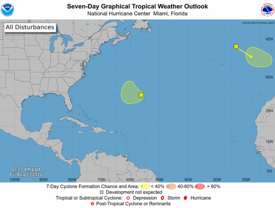
The Atlantic tropics remain tranquil. The only two features of interest for tropical development are outside the tropics. Neither would affect South Carolina if they did develop. However, there is a potential concern in the long range.
Four tropical waves are drifting through the tropical Atlantic and Caribbean Sea, but hostile conditions persist over most of the area. Upper-level westerly winds are causing vertical shear over the Caribbean Sea and vicinity, and a dry, dusty air mass remains over much of the tropical Atlantic.
Further north, the National Hurricane Center is watching a disturbance southeast of Bermuda for possible tropical development. However, it’s a long shot, and it will move northward rather than toward us. The other disturbance of interest is an extratropical storm west of Spain and Portugal that could gain tropical characteristics in time, but it will remain too far away from us to have any impact.
The above loop of visible satellite imagery above shows several features of interest across the North Atlantic and eastern U. S.:
Tropical waves are along 78° west, over the Caribbean Sea; along 50° west, east of the Lesser Antilles; along 44° west, over the central tropical Atlantic; and along 22° west, southeast of Cabo Verde.
Dry, dusty air is present between around 15° north and 25° north over the eastern tropical Atlantic.
A disturbance southeast of Bermuda looks disorganized at the moment.
A storm west of Spain and Portugal is generating thunderstorms over the eastern Atlantic.
A band of clouds associated with a front stretches across Atlantic Canada, the East Coast, and the southeastern states.
Image Source: University of Wisconsin RealEarth
The Atlantic will likely remain quiet through at least this weekend, but things could change next week. A strong tropical wave will emerge from Africa early next week, and the computer models tell us that wave is likely to develop into a tropical cyclone. This makes sense with the Madden-Julian Oscillation becoming more favorable for Atlantic activity over the next week. The eventual track is uncertain, assuming it does become a tropical cyclone. It’s enough of a challenge to predict what a hurricane will do, and much harder to tell you what a storm that hasn’t even formed yet will do. But the signal from the models is that it could become a hurricane over the western Atlantic in early September. Such a storm would at least cause beach and boating hazards along our coast. So, there’s a chance we’re on the edge of our seats watching this feature a week or so from now.
We’re in the Atlantic hurricane season’s ‘prime time’; two-thirds of all Atlantic hurricane activity occurs between August 20 and October 10. Please ensure that your hurricane kits are fully stocked, just in case ‘that one storm’ we have this season comes our way. If you need prep advice, hurricane.sc is always the place to go.
Heavy Storms Through Tonight
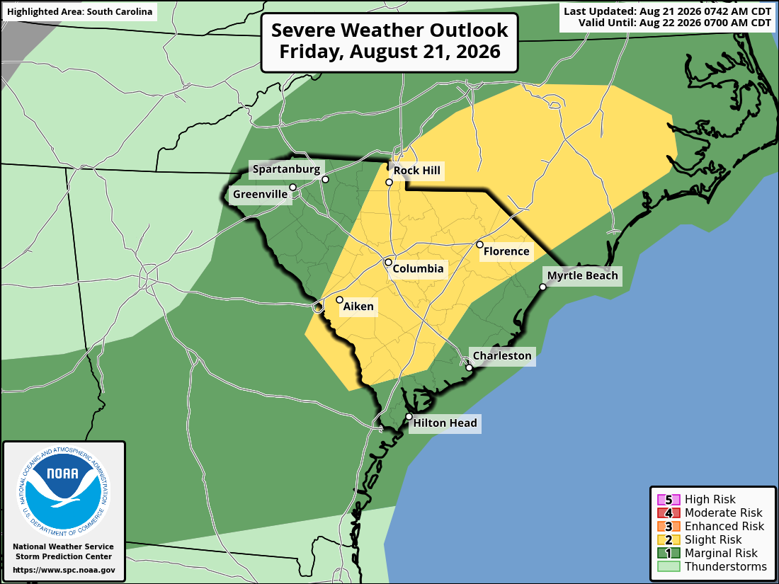
The Lowcountry is stewing again today, but the heat wave is over for the rest of the state with a cold front moving in. Even the Lowcountry will return to more typical August temperatures starting Saturday. However, the front will bring us widespread thunderstorms with a risk of locally damaging winds this afternoon and tonight, and they can also cause localized flash flooding. The main area of concern is over the middle and northern parts of the state.
Top: The Storm Prediction Center’s Day 1 Severe Weather Outlook shows the entire state with some level of risk for locally damaging wind and hail with thunderstorms through tonight, with a part of the state at risk level 2 of 5.
Bottom: The Weather Prediction Center’s Day 2 Excessive Rainfall Outlook shows much of the state at level 2 of 4 risk for flash flooding from thunderstorm downpours through tonight, and most other areas at a level 1 of 4 risk.
The front and its storms will shift to our coastal areas for Saturday and Saturday evening. Once again, there can be isolated damaging wind with the storms and perhaps localized flooding as well, but the risk will be lower than with this afternoon and tonight.
On Sunday, less-humid air will filter into most of the state and bring pleasant late-summer weather to all but the immediate coast, where an isolated shower or thunderstorm could pop up. Highs will mainly be 90-94° across the state; warm, but it will be a breath of fresh air compared to this week’s heat.
Monday looks fantastic for August with low humidity and highs in the upper 80s to lower 90s; enjoy that!
After that, it looks like the front will retreat northward and become stationary over us. So, the humidity will increase again, and we’ll have daily rounds of afternoon and evening thunderstorms starting Tuesday. Clouds and rain will keep our temperatures in check; daily highs across the state will be in the upper 80s to lower 90s, with middle 90s in the usual hot spots.
Frank Strait Severe Weather Liaison S.C. State Climate Office
South Carolina Department of Natural Resources 260 D. Epting Lane West Columbia, SC, 29172








Be the first to comment!