Watching the Gulf, More Severe Thunderstorms Possible
Weather Alert – July 17, 2026
Watching the Gulf
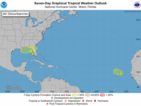
Finally, we again have some signs of life in the Atlantic tropics. There are two areas of interest out there today. One is close to home, and the other is way out there over the eastern Atlantic.
Here’s the National Hurricane Center’s (NHC’s) Seven Day Graphical Tropical Weather Outlook from Friday afternoon.
Our primary concern is a blob of thunderstorms that has erupted over the far western Gulf over the last 24 hours, associated with an upper-level low over the area. The area could (NHC gives it a 20 percent chance) evolve into a tropical cyclone as it wanders around the northeastern Gulf. Whether or not it becomes a tropical depression or storm, the most likely track will be over Florida and near the East Coast. The impacts will depend on the track and how strong of a feature it becomes, both of which are very uncertain right now. It could remain too far offshore to affect us, a disorganized plume of moisture that contributes to rain along our Coastal Plain early next week (ideal because we need the rain) or a tropical depression or weak tropical storm that brings our coastal areas heavy rain, gusty winds, a small storm surge along with a risk for isolated tornadoes. Another alternate scenario some of the computer models show is that it drifts westward instead and becomes more of a concern for the central Gulf Coast than for us. This feature will definitely have our attention over the weekend; if it will affect us, that will happen Monday night through Tuesday night.
The loop of visible satellite imagery above shows several features of interest across the North Atlantic and eastern U. S.:
Thunderstorms are clustering around a developing low-pressure area over the northeastern Gulf.
Low pressure along a tropical wave is centered near Cabo Verde and moving northeastward.
A tropical wave is near 45° west, drifting westward slowly.
Bands of smoke from large wildfires west of Hudson Bay can be seen from Michigan and Ohio through the Mid-Atlantic region and over the Atlantic north and northeast of Bermuda.
The other area of concern is over the eastern Atlantic, where a weak low-pressure area has formed along a tropical wave that recently emerged from Africa. It looks decent on satellite imagery with a swirl of clouds and some associated thunderstorms. However, it’s moving northwestward toward dry and stable air. So, it’s a long shot (10 percent chance, according to NHC) to become a tropical depression or a weak tropical storm while causing squally weather in Cabo Verde this weekend. After that, it likely remains a weak feature as it moves toward the central North Atlantic. It looks, to borrow a phrase from my favorite author, mostly harmless.
There are no other features of interest over the Atlantic today. A tropical wave is near 45° west over the middle of the tropical Atlantic, but it is very weak and unlikely to raise any ruckus in the coming days as it drifts westward.
Since there’s a small chance we’ll have to deal with a tropical storm next week, you’ll want to use the weekend to make sure your hurricane kits are properly stocked. As always, hurricane.sc is the place to go for prep advice.
More Severe Thunderstorms Possible
Another weekend, another cold front: our late week heat will ease through Sunday as another cold front moves in. We’ll see sparse coverage of routine afternoon thunderstorms this afternoon and Saturday afternoon, though keep in mind that sometimes our summertime storms become severe with isolated damaging wind. The Upstate has the best chance to see a severe storm.
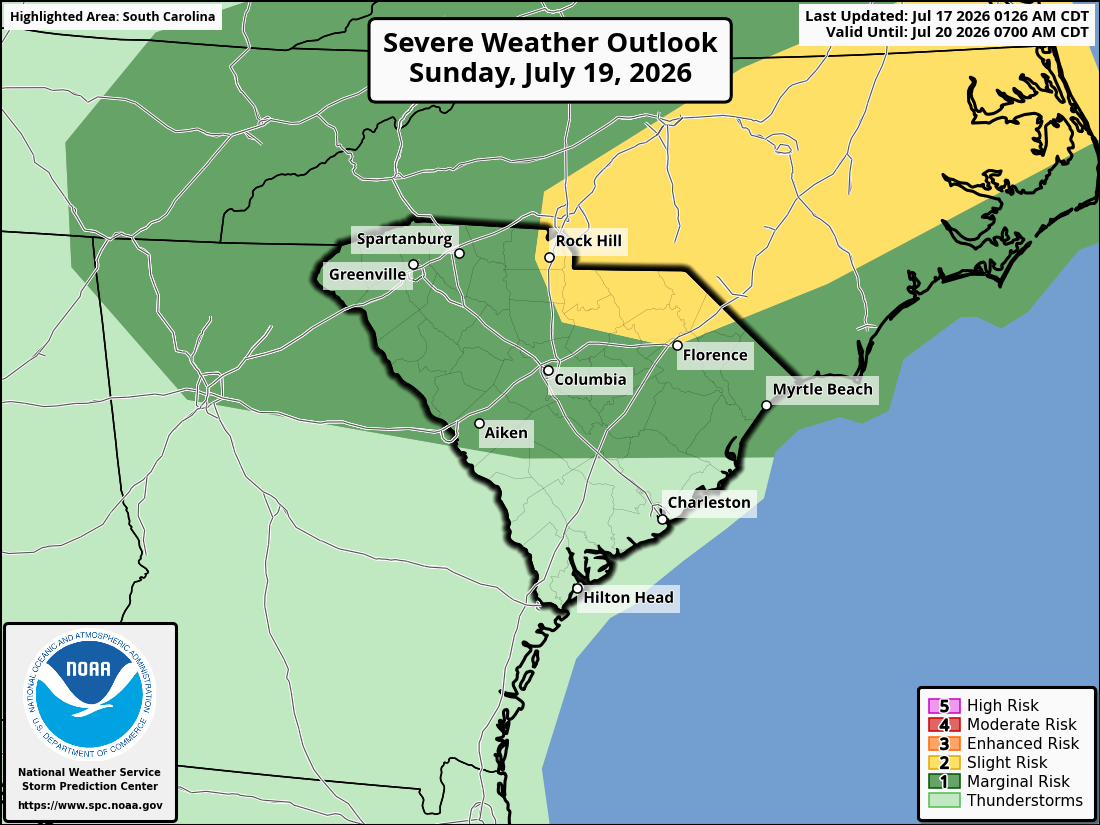
By Sunday, the approaching cold front will be over our tomato-and-vinegar-loving northern neighbors, which will increase afternoon thunderstorm coverage over the northern half of our state and increase the severe storm risk in that area. Locally damaging winds will be the primary concern with the storms.
Here’s the Storm Prediction Center’s Day 3 Severe Weather Outlook for South Carolina, covering Sunday and Sunday night.
The front will become stationary and start to decay over us on Monday, so look for widespread showers and thunderstorms that could start to pop up before midday. Once again, a locally severe storm is possible. It will be the least hot day of the next few with highs only in the upper 80s and lower 90s.
Tuesday brings us less widespread thunderstorms and more heat; highs will be 90-95° across the state. However, the feature in the Gulf is the wild card for the day, as we’ll feel its impacts Monday night through Tuesday night if it tracks toward us. Our coastal areas are most likely to see it cooler and wetter; again, low-end wind, surge, rain and tornado risk is the worst-case scenario near our coast if the feature becomes a tropical cyclone.
On Wednesday, we have better-than-usual agreement among the computer models that another cold front will move in. The front is likely to bring showers and thunderstorms, and there is a chance of severe storms again if it moves through during the afternoon and evening.
We have a chance of unusually pleasant weather for at least part of the state later next week, as the weather pattern then will favor the cold front pushing much farther south than we typically see in July. Computer models tell us the front will stall to our south and east Thursday into Friday, allowing a drier air mass to move in with temperatures running near or slightly below average. 90° with low humidity is a pretty good deal for us in late July, so I’ll be rooting for that. However, climatology isn’t on our side, so don’t be surprised if the front stalls farther north and west than the models indicate, resulting in at least part of the state seeing scattered showers and thunderstorms. Of course, with most of the state still in a drought, more rain chances are a good deal, too.
On the satellite loop above, you’ll see areas of smoke from wildfires in Canada streaming by to our north. Some of it is sneaking into the Pee Dee; you may notice some haziness that way this afternoon. The smoke will mostly remain north of us through the weekend but it may shift southward toward us next week, especially later in the week.
Speaking of drought, if you have ever wondered how we define drought and its severity, I can tell you about an opportunity to learn more. The National Drought Mitigation Center (located at the University of Nebraska) will hold an online workshop to explain how the U.S. Drought Monitor works. If you’re interested, you can read more and sign up here: NDMC’s U. S. Drought Monitor 101 signup. The workshop will be held on August 13, from 3-4 p.m. Eastern Time.
Frank Strait Severe Weather Liaison S.C. State Climate Office
South Carolina Department of Natural Resources 260 D. Epting Lane West Columbia, SC, 29172








Be the first to comment!