CURRENT LOCAL NOTICES TO MARINERS
Here are the latest Local Notices to Mariners and NAV ALERTS that are relevant to ICW cruising in Districts 5, 7 and 8, the OBX, AICW, OWW, Keys, GIWW and adjacent waters. Open each LNM link for the USCG notice and a chart for each location. Listed north to south to north. NAV ALERTS will also be posted on our Homepage.
For previous Local Notices, go to the Specific State or Region on our Homepage
Week 25/26
LNM: Off WW, NWS Tropical Atlantic Marine Weather Briefing for Thursday, June 18, 2026 19:00
LNM: AIWW MM:846.7, New Smyrna Beach Light 42 Destroyed
LNM: Off AIWW MM:0.5, Little Creek Harbor Range Rear Light Extinguished
LNM: Off WW, Hatteras Connector Buoy 6A Relocated
LNM: Off WW, Hatteras Connector Buoy 7A Relocated
LNM: Off WW, Hatteras Connector Buoy 7 Relocated
LNM: Off AIWW MM:464.7, Cooper River Lighted Buoy 52 Extinguished
LNM: Off AIWW MM:1,122.2, Key Largo Daybeacon 27 Destroyed
LNM: AIWW MM:303.1, Federal Point Range Rear Light Extinguished
LNM: AIWW MM:301.5, Sunny Point Terminal Entrance Range Front Light Destroyed
LNM: AIWW MM:301.5, Sunny Point Terminal Entrance Range Front Light Destroyed
LNM: Off AIWW MM:464.8, Cooper River Lighted Buoy 52A Extinguished
LNM: AIWW MM:342.5, Little River-Winyah Bay Daybeacon 6 Extinguished
LNM: GIWW MM:72.4, Big Sarasota Pass Daybeacon 16 Destroyed
LNM: AIWW MM:155.0, Goose Creek Daybeacon 17 Relocated
LNM: Off WW, Fisher Point Range Front Light Changed
LNM: Off WW, Fisher Point Range Rear Light Changed
LNM: Off , Frankford Upper Range Rear Light Relocated
LNM: AIWW MM:283.6, New River – Cape Fear River Light 127 Extinguished
LNM: Off WW, Salem River Entrance Channel Directional Light Relocated
LNM: Off AIWW, Neuse River Channel Light 9 Extinguished
LNM: Off WW, Lenoxville Point Buoy 3 Missing
LNM: Off WW, Chincoteague Channel Lighted Buoy 17 Offstation
LNM: Off AIWW, Oregon Inlet Lighted Buoy 4 Missing
LNM: GIWW-East MM:55.0, Marianne Channel Daybeacon 25 Destroyed
LNM: GIWW-East MM:55.0, Marianne Channel Daybeacon 25 Destroyed
LNM: Off GIWW, Hillsborough River Daybeacon 4 Extinguished
LNM: GIWW-East MM:159.1, Pensacola-Mobile Buoy 95A Offstation
LNM: AIWW MM:573.6, Fields Cut Buoy 48 Offstation
LNM: AIWW MM:573.9, Fields Cut Lighted Buoy 48A Offstation
LNM: Off GIWW-East MM:87.3, Biloxi East Channel Daybeacon 11 Set TRUB
LNM: Off , New Jersey Intracoastal Waterway Buoy 423 Relocated
LNM: Off AIWW MM:291.2, Keg Island Range Rear Light Extinguished
LNM: Off AIWW MM:174.8, Broad Creek Daybeacon 3 Missing
Week 24/26
LNM: AIWW MM:785.0, Matanzas River Daybeacon 37 Damaged
LNM: Off GIWW-East, Arlington Channel Lighted Buoy 1 Extinguished
LNM: Off WW, NWS Tropical Atlantic Marine Weather Briefing – June 14, 2026 18:30
LNM: AIWW MM:507.5, South Edisto River Daybeacon 152 Extinguished
LNM: AIWW MM:203.3, Newport Marshes Light 38 TRLB
LNM: GIWW-West MM:644.3, Arroyo Colorado Cutoff Channel South Entrance Buoy 4S Missing
LNM: Off GIWW-East MM:87.3, Biloxi East Channel Daybeacon 11 Damaged
LNM: Off WW, Stingray Point Light Damaged
LNM: Off GIWW-East, Arlington Channel Lighted Buoy 1 Offstation
LNM: Off GIWW-West MM:667.8, Piankatank River Daybeacon 11 Destroyed
LNM: GIWW-West MM:669.9, Brownsville Channel E Outbound Directional Light Extinguished
LNM: GIWW-West MM:631.0, Land Cut-Arroyo Colorado Light 79 Destroyed
LNM: Off WW, Cedar Keys Northwest Channel Daybeacon 21 Missing
LNM: GIWW-West MM:665.9, Harlingen – Port Isabel Daybeacon 87 Destroyed
LNM: GIWW-East MM:172.3, Pensacola-Mobile Daybeacon 29 Destroyed
LNM: Off WW, Piankatank River Light 15 Extinguished
LNM: Off WW, Ware River Daybeacon 2 Missing Dayboards
LNM: GIWW MM:106.2, Point Pinellas Channel Light 6 Destroyed
LNM: Off AIWW MM:684.1, Brunswick Spoil Area Lighted Buoy C Extinguished
LNM: GIWW-West MM:664.3, Harlingen-Port Isabel Light 73 Offstation
LNM: Off GIWW-West MM:541.5, Corpus Christi Channel Light 44 Improper Characteristics
LNM: AIWW MM:679.0, Cedar Hammock Outbound Range Rear Light Extinguished
LNM: Off GIWW-West MM:541.3, Corpus Christi Cut B East Range Front Light Extinguished
LNM: AIWW MM:261.8, New River – Cape Fear River Daybeacon 76 Relocated
LNM: Off AIWW MM:269.9, Banks Slough Channel Buoy 3BS Relocated
LNM: Off AIWW MM:270.0, Banks Slough Channel Buoy 2BS Relocated
LNM: Off AIWW MM:269.7, Banks Slough Channel Buoy 4 Relocated
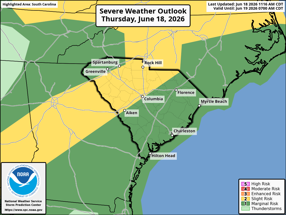
LNM: Low Country Splash, June 13, 7:30-10:00 AM, Charleston Harbor, SC AICW Sttatute Mile 465
LNM: Off GIWW-East MM:102.3, Pascagoula Channel Light 43 Missing
LNM: Off GIWW-East MM:102.8, Pascagoula Channel Light 41 Missing
LNM: AIWW MM:1,013.5, Lake Worth North Light 27 Destroyed
LNM: Off WW, Rollinson Channel Buoy 30A Relocated
LNM: Off WW, Rollinson Channel Buoy 31A Relocated
LNM: Off WW, Rollinson Channel Daybeacon 33A Relocated
LNM: Off WW, Rollinson Channel Light 34 Relocated
LNM: Off WW, Rollinson Channel Light 34A Relocated
LNM: AIWW MM:504.8, South Edisto River Daybeacon 147 Missing
LNM: Off AIWW MM:250.2, New River – Restricted Areas Closed to Navigation
LNM: Off , Hatteras Inlet Lighted Buoy 6 Relocated
LNM: Off , Hatteras Inlet Lighted Buoy 3 Relocated
LNM: Off , Hatteras Inlet Lighted Buoy 5 Relocated
LNM: Off , Hatteras Inlet Lighted Buoy 4 Relocated
Week 23/26
LNM: Off GIWW, Big Marco Pass-Gordon Pass Daybeacon 27A Destroyed
LNM: OWW MM:148.0, Caloosahatchee River Daybeacon 97 Partially Submerged
LNM: Off WW, NWS Tropical Atlantic Marine Weather Briefing – June 7, 2026 18:00
LNM: AIWW MM:772.0, Tolomato River Light 48 Destroyed
LNM: Off GIWW-West, Tule Lake Channel Directional Light D Extinguished
LNM: Off GIWW-West MM:541.3, Corpus Christi Cut B East Range Front Light Extinguished
LNM: Off GIWW-West MM:542.0, Corpus Christi Harbor Outer Range Front Light Extinguished
LNM: Off AIWW, Wassaw Sound Lighted Buoy 4 Damaged
LNM: Off OWW MM:145.2, Bimini Entrance Channel Daybeacon 24 Set TRUB
LNM: OWW MM:147.1, Cape Coral Southwest Channel Daybeacon 9 Set TRUB
LNM: OWW MM:147.1, Cape Coral Southwest Channel Daybeacon 8 Set TRUB
LNM: OWW MM:144.2, Cape Coral Boat Ramp Channel Daybeacon 6 Destroyed
LNM: OWW MM:145.0, Redfish Cove Channel Daybeacon 3 Destroyed
Week 22/26
LNM: Off GIWW MM:95.5, Egmont Channel Range Front Light is Dim
LNM: GIWW MM:110.7, Boca Ciega Bay Daybeacon 13A Set TRUB
LNM: Off GIWW-East, Jourdan River Channel Daybeacon 9 Missing
LNM: GIWW-East MM:168.5, Pensacola-Mobile Daybeacon 51 Offstation
LNM: GIWW MM:110.7, Boca Ciega Bay Daybeacon 13A Destroyed
Week 39/23
LNM: Alt ICW MM 7, Long Term Deep Creek Bridge Replacement, Dismal Swamp Canal, NC
For previous Local Notices, go to the Specific State or Region on our Homepage


 FRIDAY


Be the first to comment!