Martin County Moments: April 2020, Stuart, FL

At the intersection of the Atlantic Intracoastal Waterway and the Okeechobee Waterway, Martin County, A CRUISERS NET SPONSOR, is a hub of boating activity and of events of interest to boaters.

|


|

|

|

|

|

|

|

|
|
At the intersection of the Atlantic Intracoastal Waterway and the Okeechobee Waterway, Martin County, A CRUISERS NET SPONSOR, is a hub of boating activity and of events of interest to boaters.
|
|
|
|
|
|
|
|
|
|
At the intersection of the Atlantic Intracoastal Waterway and the Okeechobee Waterway, Martin County, A CRUISERS NET SPONSOR, is home to Marine Industries Association of the Treasure Coast and a hub of boating activity and events of interest to boaters.

| |||||||||||
This is an absolitely foolhardy idea and the MIATC should know better. It has been shown over and over that people don't control themselves especially weekend party boaters. The closure of ramps and marinas in Miami, Broward and Palm Beach counties was due to the poor behaviour of boaters AFTER they had been asked to do the same thing without avail. It's sad to say but if you truly wanted to help stop this virus, you would be requesting the closures to help protect people from themselves.
At the intersection of the Atlantic Intracoastal Waterway and the Okeechobee Waterway, Martin County, A CRUISERS NET SPONSOR, stretching from the east coast to the eastern shore of Lake Okeechobee, is a hub of boating activity and of events of interest to boaters.
|
|
|
|
|
|
|
Fort Pierce City Marina, A CRUISERS NET SPONSOR and a public facility, is located west of the Waterway, just south of the Fort Pierce high-rise bridge and well north of unlighted daybeacon #188. Fort Pierce City Marina has been undergoing extensive renovations. See FOCUS ON for more on this excellent facility.
New Fuel Dock office getting roof.
Click Here To Open A Chart View Window, Zoomed To the Location of Fort Pierce City Marina
Cruisers Net has confirmed that pumpout service will not be available at Fort Pierce City Marina until new pumpout lines have been installed. No completion date is projected due to the reconstruction complexities. Fort Pierce City Marina, A CRUISERS NET SPONSOR, is aware of the new regulations at Vero Beach City Marina and of the inconvenience boaters may experience in trying to find pumpout service.
For an unknown length of time, the Fort Pierce City Marina will no longer be able to offer pump-outs anywhere on-site due to construction – not at their fuel dock nor at any dock slips as usual. Whether just a fuel stop and/or transient dockage – keep this in mind. To verify the current situation, please phone in advance so you can plan to pump-out elsewhere prior to your arrival, if needed.
Russ Rackliffe
Click Here To Open A Chart View Window, Zoomed To the Location of Fort Pierce City Marina
Cruisers Net has confirmed the new regulations at Vero Beach City Marina. Please phone the marina before docking to arrange a pumpout: 772-231-2819 or 772-978-4960.
11/10 Cruisers Net received this cuarification from Vero Beach Marina:
New Vero Beach City Marina Pump-out Mandatory Requirements
The Vero Beach City Marina has just instituted new requirements for any vessel coming in for a dock or mooring. You MUST now come to the fuel dock for a mandatory pump-out FIRST before going to your slip or mooring. You will also be issued a numbered cable tie for your discharge valve. This has apparently been pushed on them by environmental groups & will be enforced with “random sweeps” by the Florida Fish & Wildlife Agency (as reported in the media).
Russ Rackliffe
The poster is correct. Mandatory pump out unless you can produce a pump out log showing a recent pump out
At the intersection of the Atlantic Intracoastal Waterway and the Okeechobee Waterway, Martin County, A CRUISERS NET SPONSOR, is a hub of boating activity and of events of interest to boaters.
Seafood Festival, Boat Show and Flea Market – what more could you want?
Click here for Featured Upcoming Florida Marine Exhibitor and Vendor Events
Once again, Jim Healy graciously imparts his experience in response to a Looper’s questions on AGLCA’s Forum with an excellent description of the Okeechobee Waterway. Jim is a true cruiser helping cruisers! Thank you Jim.
1) How many days should we anticipate to cross Florida going west at 9 knots. Currently thinking 1 day to Pt Mayaca, day 2 to Clewiston or Moore Haven, then day 3 and 4 from Moore Haven to Alva, FL (WP Franklin Lock).
“It all depends.” This trip is “Old Florida.” This is orange grove and sugar cane country. On the St. Lucie Canal, there are marinas at Stuart and Indiantown. There is a Corp Of Engineers dock at St. Lucie Lock with is $15/day with a Golden Age Pass. There’s not much/nothing to see at these stops, so one night overnights are typical for cruisers. A place to shower and sleep. So, typically, what we do is stop at the anchorage in Stuart. Then, Stuart to Clewiston. Then, Clewiston to Ft. Myers. I recognize that is a longer day than some people may want, but we do this trip twice a year, and as I said, very little to see. We stay at Roland Martin’s in Clewiston. Very nice Tiki Bar, and a relaxing place. Sammy the dockmaster is a wonder to enjoy. There are nice public docks in Moore Haven with power and water for $1.00 per foot. There are public docks at the library in Labelle. First come, first serve; Med Moorings. Good wifi. It’s the only place in the canal system to actually see a town. There is also a COE dock at the WP Franklin Lock; also $15/day with power and water. There are two locks on the St. Lucie Canal and three on the Caloosahatchee end. The highest lick is St. Lucie; around 16 feet vertical lift.
2) Where best to dock/anchor along the route?
You are permitted to anchor in the canal after closing at 1700. No one does [anchor] on the St. Lucie end except at the lock, on the north side.. You cannot anchor in the canals during the daytime hours of lock operation.
3) Is it better to cross the lake (route 1) or go the rim route (route 2)? What criteria to decide?
DO NOT TAKE THE RIM ROUTE WITH A 5′ DRAFT. PERIOD. We have never taken the Rim Route. The cross lake route is shallow enough, and even more so this year. The Southwest Water Management District has been holding the lake level down to avoid large water releases of the vile Lake O water into the canals. Not sure it’s doing any good, but check the Route 1 water depths. In the spring, we crossed when there was only 5′ of water, and the place that will affect you is the 5-mile channel from the lake into Clewiston.
4) What water level reading do we need from COE for our 5′ draft?
Five feet, of course. There are two places where the control depth is measured. One is in the channel out into the lake at Port Mayaca, the other is the channel from the lake into Clewiston. STAY IN THE CLEWISTON CHANNEL. The lake bottom is limestone, not sand. The Clewiston channel is dug, so the edges are rock. Much like the “Rock Pile” in South Carolina. There is no tide in the lake, but winds can change water levels at the north and south by as much as a foot or more. Watch winds that have been blowing for many days…
Bonus Question: What the current status of the Red Tide?
Yes. Red Tide is a problem on the gulf, not in the lake. IT IS A NATURAL PHENOMENA, NOT RELATED TO POLLUTION. It’s blue/green algae that you have to worry about in the canals and lake. Both conditions are problems in Florida. DO NOT SWIM IN THESE WATERS. They do contain nasty bacteria, but there are larger reptile hazards here, too. Big lizzagators live here. We wear nitrile exam gloves when handling lock lines.
Heading East to West consider 1) sunset bay marina & mooring field @ Stuart ( 2) transient docks at Indiantown Marina (3) Clewiston Roland Martins transient docks or Clewiston City Docks (4) Moore HAven City & (5) stop at Ft Myers City Marina at downtown There might be newer facilities since I have not crossed in many years. Enjoy.
Loved Franklin locks Campground and docks!
At the intersection of the Atlantic Intracoastal Waterway and the Okeechobee Waterway, Martin County, A CRUISERS NET SPONSOR, is a hub of boating activity and of events of interest to boaters.
| ||||||||||
MIATC is asking for donations of household items that can be transported to the Bahamas. At the intersection of the Atlantic Intracoastal Waterway and the Okeechobee Waterway, Martin County, A CRUISERS NET SPONSOR, is a hub of boating activity and of events of interest to boaters.
| |||||||||||||||||
At the intersection of the Atlantic Intracoastal Waterway and the Okeechobee Waterway, Martin County, A CRUISERS NET SPONSOR, is a hub of boating activity and of events of interest to boaters.

|
|
|
|
|
|
|
|
|
|
You’re in our family. Now let’s be friends.
Now that you’re a part of the Discover Martin County family, let’s be friends! Here is where you can find us: | |||||||
| |||||||
While we love communicating with you via email, we would hate clogging up your inbox everytime we publish a new article, find an amazing vacation deal, or want to share one of fantastic pictures. So, if you’d like to get to know Martin County, let’s be friends. |
At the intersection of the Atlantic Intracoastal Waterway and the Okeechobee Waterway, Martin County, A CRUISERS NET SPONSOR, is a hub of boating activity and of events of interest to boaters.
|
|
|
|
Now that you’re a part of the Discover Martin County family, let’s be friends! Here is where you can find us: | |||||||
| |||||||
While we love communicating with you via email, we would hate clogging up your inbox everytime we publish a new article, find an amazing vacation deal, or want to share one of fantastic pictures. So, if you’d like to get to know Martin County, let’s be friends. |
Our thanks to author and experienced cruiser Robert Sherer for this report from his Facebook page, Bob423. The reported obstruction appears to be near marker 136 less than a mile north of the Merrill Barber Bridge.

AREA CRUISERS NET SPONSORING MARINA
I have an ancient (2009) copy of Skipper Bob's Anchorages Along the ICW which says (p.86):
"Vero Beach: Caution, favor green side of channel near R128. Rock in center at 5.5' known by locals as the 'rock pile'."
Might this be the same obstruction?
Among our readers there must be several who are experienced in cruising the AICW in a vessel this size. If so, please let us hear from you. Maybe Chief Officer Perks will take you along as Pilot!
Good morning,
I am currently trying to find any information I can about cruising in Northern Florida. We are a 151ft vessel with a 8ft draft. We would like to cruise the Jacksonville, St Augustine and Cape Canaveral areas. Is there anyone you recommend for me to talk with about the ICW routes and Marinas that could accommodate us?
Thanks in advance,
Andrew Perks
Chief Officer – Motor Yacht Time for Us
Hope you have good anchors. Just plan on staying near the inlets, any venture up or down the ICW from Jax or St Aug would be most difficult with your draft. Plenty of dockage for you in downtown Jax on the St Johns, but watch the currents since it rips thru downtown on the outgoing tide. Call ahead in St Aug for assistance with the inlet as it shoals as fast as they move the buoys. Port Canaveral is your best shot, no current, extremely safe inlet and once into the Indian River you will have deep ICW north and south for at least 20 miles, but no marinas outside Port Canaveral that will accommodate your size (both length and mass) pushing on their docks.
With an 8 foot draft , parts of the ICW can only be safely run at high tide. After leaving Haulover as you arrive at Daytona, do not take any of the side channels. Just before Matanzas, make sure you hug the GREEN side of the channel. Recommend taking bridge of lions at the start of an incoming tide. You will be pushed to the west side of the bridge during transit.
I’ve pushed 200’ barges on the route with a 7 foot draft so it’s doable with care
Vero Beach is home to Vero Beach Municipal Marina, A CRUISERS NET SPONSOR. The marina lies on the eastern shores of Bethel Creek, northeast and north of the Vero Beach/Merrill Barber high-rise bridge.
Fall In Love With Vero Beach
Atlanta Magazine
Fort Pierce City Marina, A CRUISERS NET SPONSOR and a public facility, is located west of the Waterway, just south of the Fort Pierce high-rise bridge and well north of unlighted daybeacon #188.
Many of us who enjoy cruising on coastal waters have probably heard that the “Sunset City” is San Francisco, CA.
But do you know what city is the “Sunrise City”?
It is ideally located on Florida’s eastern beautiful sandy shores and is …..

Fort Pierce City Marina at sunrise
Fort Pierce and San Francisco are actually “Sister Cities” with their acclaims as the Sunrise and the Sunset cities.
Cruising southern Florida and maybe on to the Keys or Bahamas, a visit to this slice of ole Florida charm and hospitality will be well worth your time.
The town of Fort Pierce is located on what is called Florida’s “Treasure Coast.”
The Treasure Coast refers to the tons of treasure reportedly left at the ocean’s bottom by ships sunk in this immediate area.
The major drawing card here is the Spanish “Silver” Fleet sunk in this area in 1715.
Here’s a map outlining the Treasure Coast area in red for you “treasure hunters.”
Who knows, it just might be able to help you find a Spanish coin or two!
The city got its name from an Army post that was in the area named for Benjamin Kendrick Pierce, a career US Army officer and brother of President Franklin Pierce, hence the name, Fort Pierce. As the town gradually built near by, it took the name in 1838.
Fort Pierce City Marina first opened in 1938, ideally located in the heart of the town’s business district and local parks.

Circa 1948 Ten years after opening
So much is within easy walking distance: excellent places to eat and one of our favorites is 12-A Buoy for excellent seafood. A nice stroll along Indian River Drive brings you by the Manatee Observation and Education Center, http://www.manateecenter.com and the A.E. Backus Museum and Gallery which is home to paintings by this local native of Ft. Pierce well known for his tropical landscape paintings, http://www.backusmuseum.com/.
Also nearby are many interesting places to visit such as:
National Navy SEAL Museum https://www.navysealmuseum.org/
Ft. Pierce Inlet State Park https://www.stateparks.com/fort_pierce_inlet_state_park_in_florida.html
which provide an abundance of recreational opportunities.
The breathtakingly beautiful half-mile beach welcomes visitors for swimming, snorkeling, surfing, and scuba diving. Beachcombing, picnicking, or just relaxing on the sand are also popular activities, and a slightly longer walk or short bike ride will take you to Heathcote Botanical Gardens, https://www.heathcotebotanicalgardens.org/.
Provisioning for your crew is rather special as each Saturday, Fort Pierce boasts one of the best farmer’s markets in all of Florida and it is ranked in the top five nationally, https://www.fortpiercefarmersmarket.com/.
Now that has to be some kind of Farmers Market.

Fresh baked bread

Over seventy vendors
And then on Wednesdays, the “Green Market” also takes place, so every skipper should be able to have some of Florida’s freshest produce aboard for all to enjoy.
On the social side, weather permitting, the first Friday of each month there is a “Street Party” with live music where you may meet new friends, and we are sure you will have some good ole fashioned enjoyment.
Going offshore for the Bahamas, one of Florida’s best east coast inlets is the Fort Pierce Inlet, known to be the “best all weather inlet on the east coast.”

Fort Pierce Inlet
The inlet and surrounding Indian River Lagoon provides many spoil islands to enjoy on day trips with the family, or kayaking, or enjoying a picnic, but also easy access to the Atlantic and world-class fishing waters…and between us “friends,” maybe find a Spanish silver coin or two.

Spoil islands anchorage
Fort Pierce City Marina is eighty years young as this is being published. This first-class marine facility has not only stood the test of time, but this marina continues to lead with improvements, such as their $32.8 million dollar waterfront Island protection project, new floating docks, their “first in the state” eco-friendly Storm Protection System and improved yacht friendly navigation.
| Fort Pierce City Marina in 2007… | and here’s the marina in 2016 … |
 |  |
You have to visit and see first hand how this marina management team has worked hard and smart to develop something very unique that not only protects its marina slips but contributes to the local sea habitat, both fish and fowl.
Also provided for the cruising community is a new dinghy dock so cruisers can have easy and comfortable access to the town.
Ft. Pierce City Marina provides all the amenities of home: clean comfortable facilities, free wifi, two fueling stations, complementary pump-outs, two restaurants on site, pet friendly, supply store, etc… (see marina features below).
Fort Pierce City Marina is just south of South Bridge on the Atlantic ICW at Statute Mile 966.5. The entrance channel is relatively new, a couple years old now, just be sure your charts are current.
Contact them on VHF #16 or #17, or
Call via your cell phone to 800.619.1780 or local 772.464.1245.
Web site – http://www.fortpiercecitymarina.org/
Enjoy your stay with this team of professional marina providers. They are truly a skipper’s resource and excellent host for you as you enjoy your trip through this part of Florida. Many have come for a visit and, well, now Ft. Pierce City Marina is their home port. Let your team here at Cruisers Net know about your visit to Fort Pierce City Marina.
Marina Features
|
|
Click Here To Open A Chart View Window, Zoomed To the Location of Fort Pierce City Marina
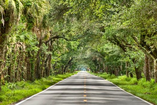
At the intersection of the Atlantic Intracoastal Waterway and the Okeechobee Waterway, Martin County, A CRUISERS’ NET SPONSOR, is a hub of boating activity and of events of interest to boaters. Now, rent a car and enjoy these scenic drives!

|
At the intersection of the Atlantic Intracoastal Waterway and the Okeechobee Waterway, Martin County, A CRUISERS’ NET SPONSOR, is a hub of boating activity and of events of interest to boaters.
| |||||||||||||||||||||||||||||
Palm Bay is a city on the Indian River in Brevard County, Florida, between Melbourne and Malabar.
Florida Inland Navigation District to deepen Intracoastal Waterway through Palm Bay from Florida Today
Click Here To Open A Chart View Window Zoomed To the Location of Palm Bay


Be the first to comment!