Captain Reeves comments are in response to earlier postings on shoaling waters, such as Little Mud River: /?p=128659, and many other such reports. ARGUS is a great tool in those areas already documented to be shoaling, as well as those where a captain might suspect a shift in the channel.
If the prudent navigator compares the new ARGUS soundings on all problem areas, there is a clear path to take and it is not the red line. I like the ARGUS soundings, because I can zoom in and see the depths and where they are. I don’t cruise the world now days, but I do enjoy the ICW on the Georgia Coast and it is nice to have accurate information and lots of different views. I do hope cruisers can continue to enjoy the ICW by using the excellent resources here and pay attention to their charts, depth sounders and common sense. Sonny Reeves, Jekyll Island
As a long time fan of Argus, we have had the system installed on Beach House for the last year as we cruise. We are happy to contribute to the database and find this an invaluable tool for boaters. Thanks for making the information available on Cruiser’s Net. Chuck and Susan, Trawler beach House
ARGUS Readings through Little Mud River - Click for Chartview
On any SSECN chartview, simply click the ARGUS box at the top of the screen to bring up the ARGUS symbols.
The shallow waters north and west of marker #24 are not, AND NEVER WILL BE, an SSECN recommended anchorage, but as Captain Reeves observes and documents, they are getting a lot of use. Given the narrow, constantly shifting channel that barges must navigate in Jekyll Creek, cruisers choosing to anchor north of marker #24 will be wise to put out a short scope and to stay well west of marker #24. Our thanks to Captain Reeves, from Jekyll Harbor Marina – A SALTY SOUTHEAST SPONSOR! – for pointing out this potential hazard. The Anchorage at Red 24 south of Jekyll Harbor Marina is getting a lot of use this season. My concern is when boats anchor to the east of the marker R24 and are in the ICW. You know we have a lot of BIG barge traffic on this part of the ICW. I am attaching pictures from last night that show a boat anchored in the ICW east of the marker. One boat did not have an anchor light. We had a boat hit 2 years ago by a barge, just the corner! The owner was saved but lost his boat. He was anchored near the public dock east of R24. Cruisers are welcome to anchor and visit the Marina in their dingy for shore access or to use the public dock. Of course they are always welcome at the Marina. Call Tow Boat US or the Marina for local knowledge. Stop by and visit with us we will be in The Office. Sonny Reeves
Jekyll Harbor Marina, A SALTY SOUTHEAST CRUISERS’ NET SPONSOR!, lies along the easterly banks of the AICW’s passage through Jekyll Creek, immediately south of the 65-foot fixed bridge. The report below is from our good friend, Sonny Reeves, who keeps us updated on all things Jekyll. All Waterway cruisers, north or southbound, will pass Jekyll Harbor Marina and Jekyll Creek has been a Problem Stretch for some time.
Jekyll Creek - Click for Chartview
Cruisers who navigate through Georgia already know that the Waterway’s trek through Jekyll Creek is one of the real “problem stretches” between Little Mud River and the Georgia – Florida state line. And, the shallowest spot is found abeam of marker #19.
Hi Larry, Here is an update for the creek and Marina at Jekyll Harbor. Sunsets have been very nice and the weather has been cool with some warm days. We have had a lot of transients and right now the face dock is full with all inside slips full. Many leave today to start their journey South.
Jekyll Harbor Marina Face Dock
We heard a distress call on 16 and the Coast Guard responded but no one replied. Some one hit the dsc switch on their radio after the call but the CG could not trace it because the device was not registered. St. Andrews Sound to the South can be quite rough in bad weather. Call the Marina or Tow Boat for local knowledge when in doubt. Many boats are anchoring in the creek near R24 get real close to the ICW channel. One was clearly in the channel last week. This is a dangerous place to anchor if you are not out of the channel. See pictures of the barge attached. Several of these barges come through at varying times.
AICW Tug Passing Jekyll Harbor Marina
Specs for Sun Commander http://www.tugboatinformation.com/tug.cfm?id=3516 Note that the barge is drawing very little unloaded, but the Tug “Sun Commander is a 62 ft boat with an 8 ft draft. The tug Captains know the creek and stay in the channel not necessarily on the “Line” I took the pictures of Sun Commander at around 8:15 Note the attached tide chart showing the depths when the Sun Commander went through the creek. http://www.tides4fishing.com/us/georgia/jekyll-island-marina-jekyll-creek Hope this helps, Sonny The Office Jekyll Island Georgia 31527
Morningstar Marina at Golden Isles - Click for Chartview
Morning Star Golden Isles Marina is located on the Frederica River, between Lanier and St. Simons Islands, south of the charted 9 foot bridge. Depart northward from the Waterway south of ICW marker #247 and Frederica River marker #1. While the Frederica River has good depths north of the marina, access from the Waterway north is not possible because of the fixed 9ft clearance bridge.
We stayed over the windy and rainy 2013 Thanksgiving weekend at this pleasant and well maintained marina. There were some challenges getting 30 amp electric service since the whole facility is wired 50 amp and there were no splitters available, but the dockmaster did his best and we were able to find a spot on the rack & stack dock with electric we could use. It was a very friendly crowd there, and the daily two for one happy hour at the onsite lounge was the place to meet up. Nice showers and other shoreside amenities, our only quibble was that the free morning paper and muffins never materialized. Jonathan Gorham
Our good friend, Sonny Reeves, who keeps us posted on all things Jekyll, sends these pictures from Jekyll Island beach where a shrimp boat has gone aground, probably during those recent, on-shore high winds. We can only hope that this never happens to any of you!
Our good friends, and SSECN strategic partners, Captains Mark and Diana Doyle, founders and owners of “On The Water ChartGuides” (http://www.onthewaterchartguides.com/), give us an updated, graphic report below, relaying what they discovered as they navigated through the AICW – Little Mud River Problem Stretch on 11/20/13! Note that the Doyle’s soundings were taken near mid-tide, so to calculate MLW depths, you must subtract 4.8 feet from their figures. Applying this correction, Diana and Mark noted multiple MLW corrected 4-foot soundings along this perennial AICW Problem stretch. And, as Mark and Diana note, there are almost certainly even shallower spots. Our cruising duo are also quite right in noting that, “the reigning champion of this year’s ICW Trouble Spots is Georgia’s Little Mud River.” I might also add that very dubious distinction has been true of Little Mud River for many years now. If and until this AICW Problem Stretch is fully dredged, I would be hesitant to navigate anything bigger than a canoe through this portion of the Waterway at low tide!
Hi Claiborne, As I’m sure you’ll agree, the reigning champion of this year’s ICW Trouble Spots is Georgia’s Little Mud River. With depths as low as 4 FEET MLLW, Diana and I wanted SSECN readers to have this printable graphic of our November 20th survey report and depth-annotated track: Best wishes on this Thanksgiving holiday, Captains Mark & Diana Doyle m/v Semi-Local http://www.OnTheWaterChartGuides.com
The alternate route discussed below by Captain Byron is the Umbrella Cut Route which takes you northbound from Mile 696 in Cumberland River through Floyd Creek, across the Satilla River and into the Little Satilla to rejoin the AICW at Mile 686 in Jekyll Sound. This is often considered the route of choice when the primary Waterway route through St. Andrew Sound is kicking up. If southbound, do NOT confuse Umbrella Cut with Umbrella Creek where severe shoaling has occurred.
11/25/13 Six years ago when we were headed south we used the Umbrella Cut successfully to avoid crossing St. Andrews Sound when the seas were running high. This year the winds were 20 knots from the northeast and we wanted to try it again but were surprised that there was no recent info. We checked with locals and decided to try it on a mid and rising tide. We found it is still a viable alternative. We timed our approach for 2 1/2 hours before high tide. Our boat is a 34 foot trawler with a 4 ft draft. There was a strong following sea and as we made the turn into the cut we were pushed out of the channel where we saw 7 ft. That gave us pause but we kept going and found nothing less than 9 or 10 all the way through. We stayed midchannel away from the markers and kept to the outside on unmarked curves. We transited the alternative route all the way through Fields Creek without incident. As we exited and rejoined the ICW shortly behind us came a 45 foot boat out of the channel as well. I hope this observation is helpful. Connie Bryon
We also took the umbrella cut October 14, 2012 due to seas being up. We went through at low tide and had only 1 depth alarm at 3 feet which I cleared immediately and the depth went back to 6 feet. Most of the passage we had depths of 5 to 8 feet. We stayed in the middle of the waterway when there were no markers. I was concerned about using the cut with the horror stories out there. We stoped at Jekyll Harbor Marina to ask the locals about the cut. They said they use it all the time and I would have no problem. We also had a 40+ foot sport fishing boat follow us through at low tide. Richard Clagett
Thank you all for the great post up, as we say on the big river. Am planning on going north on the AICW this coming spring and it has been very helpful hearing from light draft vessel operators! Capt. Jerry Robbins
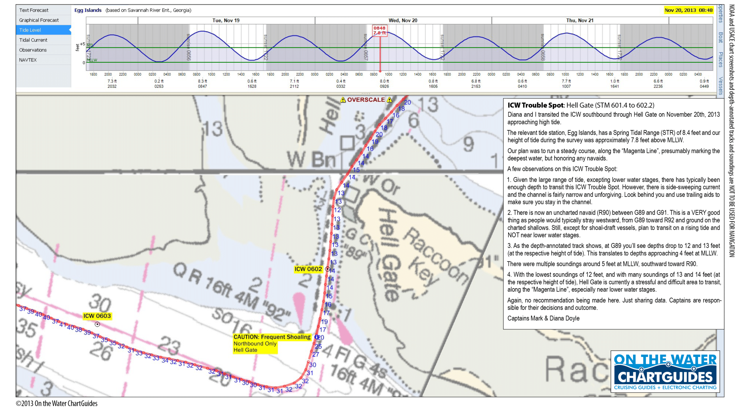
Our good friends, and SSECN strategic partners, Captains Mark and Diana Doyle, founders and owners of “On The Water ChartGuides” (http://www.onthewaterchartguides.com/), give us an updated, graphic report below, relaying what they discovered as they navigated through the AICW Hell Gate Problem Stretch on 11/20/13! Note that the Doyle’s soundings were taken near high tide, so to calculate MLW depths, you must subtract 7.8 feet from their figures. Applying this correction, Diana and Mark noted “multiple soundings around 5 feet at MLLW, southward toward R90.” PERHAPS THE MOST USEFUL PART OF THE DOYLE’S REPORT, IS THEIR DISCOVERY OF A NEW, UNCHARTED MARKER, #90, LOCATED BETWEEN CHARTED MARKERS #89 AND #91! Be sure to observe the new #90 marker as you cruise through! Incidentally, Diana and Mark have recently published a new edition of their immensely popular “ICW CruiseGuide.” Click on the book graphic to the above left for more details, and to place an order!
Hi Claiborne, For those transiting Georgia, Hell Gate has a new, uncharted navaid that should help passage through the shallower sections of this perennial ICW Trouble Spot. I’ve attached a printable high-resolution file of our November 20th survey report and depth-annotated track. Hopefully, SSECN readers cruising this area will find the report useful. Best and hope to see some of the Cruisers’ Net gang at this year’s St. Marys Cruisers Thanksgiving! Captains Mark & Diana Doyle m/v Semi-Local http://www.OnTheWaterChartGuides.com
Just transited Hell’s Gate on 11DEC2013. Delivery of 58′ power vessel with 5’4’³ draft. Passed through at 0620, with tide at approx +2.2. Minimum depth noted was approx. 2.5′ under under running gear. Captain Rob Welling
According to a spokesperson at the Delegal Creek Marina, their entrance channel MLW depths are 3 ft, with a tidal range of 8-9 ft, so mid to high tide would be the best time to enter Delegal Creek. Once in the creek, soundings improve, but clearly this marina’s entrance depths are an issue if your vessel draws more than 3 ft. Delegal Creek Marina’s entrance passage lies northeast of AICW marker #86. just north of Hell Gate.
Sanctuary and crew spent a couple of days at Delegal Creek Marina from 11/6 – 11/9/2013. The entrance to Delegal Creek from the Vernon River/Ossabaw Sound IS NOT correctly drawn on the chart (US5GA24M) of the area; the land features have changed since the chart was produced. Cruisers can download a “local knowledge” satellite view chart from the marina website, or contact Billy, the dockmaster at Delegal Marina, for local knowledge. The region has a 6′ – 7′ tidal range, larger during celestial periods. Sanctuary and crew entered Delegal Creek about 1 hr after celestial low tide (16h00, 11/6/2013), which wound up being equivalent to MLLW on our tide almanac. There is only one short stretch of shallow water on the entire route from the Vernon River to the marina. For about 20 – 30 yds immediately upstream of G’3′ and R’4′, we saw as little as 4.9 ft. at MLLW. Except for that stretch, water depths in Delegal Creek are not a concern. Minimum depths in marina slips are 6′ all the way against the inner wall. Depths at the fuel dock and face docks exceed 20 ft. The facility is very well protected, has floating docks, wi-fi, restrooms, showers and laundry. Broadband WLAN coverage is 4 bars and fast. Facilities are “newish,” well maintained and clean. Marina guests can get a “pass” from the dockmaster that allows access to all of the member-only clubs, including the several golf courses, in the Landings community. There is a small commercial center that has banks, ATMs, a food market, shoppes and restaurants. Golf carts are available for touring the Landings communities and Skidaway Island. Billy makes every effort to help visitors. This is an excellent stop. Peg and Jim Healy aboard Sanctuary, Monk 36
When we were there July 1, I created a JPG graphic to show the route in. I sent it to the dockmaster so they could us it on their web site to help boaters feel more comfortable about the entrance. Well since reading your post, I looked on their web site and now they have a fancy graphic of GOOGLE MAPS view showing the approach. It’s a PDF file that can be seen if you click on either of the following hyperlinks: Delegal Creek Approach Chart
We also found this marina to be very CUSTOMER SERVICE focused. We arrived just minutes before a major thunderstorm. Needed to get milk and bread but didn’t want to take the golf cart into town because of the imminent storm. The girl working the dock actually knocked on our boat and offered to go to the store for us ! We were so grateful ! Ralph Yost
Jekyll Harbor Marina, A SALTY SOUTHEAST CRUISERS’ NET SPONSOR!, lies along the easterly banks of the AICW’s passage through Jekyll Creek, immediately south of the 65-foot fixed bridge.
Every cruiser going north or south along the Georgia ICW will pass Jekyll Harbor Marina, just below the bridge to Jekyll Island at AICW mile 684. There is always a concern about currents or water depth as I pass this marina so I know looking over a marina is the last thing I want to do; I just want to get safely out of the area. Recently things were different and I needed a place to weather out a storm near St Andrews Sound and called the folks at Jekyll Harbor. They couldn’t have been more accommodating in every way possible. Not only did they do a great job of snatching me off the waterway in strong currents, they arranged a van to take several of us to dinner over at the Club that night. Their dock prices are reasonable and the staff is most helpful. The General Manager, Scott Todd, has even offered that if 6 or more boats come in together, he will personally cook supper for everyone. Make a note of that offer for the Spring migration northward. Stay safe, Tom
We too stopped at Jekyll Harbor on our way to Charleston last month. I was pleasantly surprised at the service and the shuttle available. We didn’t have any issues with the strong current because they put us on the outside of the lay along dock. I also recommend this as a convenient stop either north in the spring or south in the fall. Bill Borchet
This new Jekyll Island bike trail, described below, just adds another to the many reasons to stop at this historic and quite lovely isle. Jekyll Harbor Marina lies along the easterly banks of the AICW’s passage through Jekyll Creek, immediately south of the 65-foot fixed bridge. These good folks are a SALTY SOUTHEAST CRUISERS’ NET SPONSOR. Thanks to Captain Crafton for this delightful report and for an earlier report on the bike trail, see /?p=113962
Yesterday, while taking the tour of the island along the new path that connects Jekyll Harbor Marina to the historic district and beyond without having to be on the roadway, we stopped at a small tidal creek and were delighted to see manatees feeding on the marsh grass. Manatees visit Georgia from April through October. We normally are here after that so we had not seen them in this location before. But what a sight: a baby and 2-3 adults munching away on the grass leaning out over the water. The new pathway traverses a marsh area with stunning views of the environs. While staying at the Jekyll Harbor marina, transients may borrow their bikes or walk the path to the historic center. It’s a mile + or -. Georgia DNR would appreciate a call and/or photos of any manatees or sea turtles you may see while transiting this area Martha Crafton Sandpiper
Whenever I get together with a group of cruisers interested in exploring Georgia’s coastal waters, the topic always seems to arise about whether it’s better to berth at one of the several transient friendly marinas in Thunderbolt, GA, and then take a taxi into the Savannah Historic District, or cruise upstream to Savannah, and spend some time at SALTY SOUTHEAST CRUISERS’ NET SPONSOR, Savannah Hyatt Docks, or one of the other downtown Savannah facilities. A part of these discussions the possibility is almost always raised at to whether your vessel will be jostled by the wake of a passing freighter or other ocean going vessel. Happily, Captain Tom reports below that he did not encounter any such problems during his visit.
For years, I have read how rough the wakes are on the Savannah River, right downtown; but pleaded with myself to give it a personal try. It was actually fine. The big freighters which pass on average once an hour do not kick up the water that much, the tugs and ferries some more but still not uncomfortable. The only major wake maker was a Coast Guard vessel making a non-emergency run so fast that he was sending water over the top of his boat too. Savannah has so much to offer in history and culinary delight. Patsy and I have not had so much excellent Southern cooking in our memory, even the grits were always done properly. A history buff could stay on the River forever and still learn new things. Then, there is the River itself. TV could not hold a candle to the entertainment of seeing the River activity with so many boats coming and going or people just walking the river side. The dockage rates are high but well worth the experience. Include Savannah in your cruising plans. Stay safe, Tom
We are on the Savannah River docks right now. We always stop here going N and S. Take the visitors center elevator to town level and walk up Bull St. You see all the best squares of the town. It is not too bad wake wise. Huge container ships come and go all night. Last night though I awoke to a very loud blast that in my sleep sounded like my alarm clock. It was a freighters horn which lasted over a minute right outside the boat. At least on this stop the trumpet player looking for tips, who repeated `the Saints ‘ incessantly and badly played, was missing. It’s all part of the experience. Greg Han
I, too recommend a trip up the river to Savannah. Most of the time you are fine, but the occasional heavy wake does mean you should take some extra care tieing up and put out your biggest fenders. You are right in the middle of Savannah, so it is great for enjoying the restaurants, strolling, and the night life. It is one of the most walkable cities on the ICW, though there is no large grocery store nearby’“enjoy the many great eateries. One night I heard a loud saxophone playing and stuck my head out of the hatch to find out we were the scenic backdrop for a live musician performing before a large crowd. John Kettlewell
The AICW follows the short and narrow, man-made canal known as Hell Gate between the Vernon and Ogeechee Rivers. These waters have been an “AICW Problem Stretch” for years.
Captain Kipnis’s report agrees with a report from June of this year, /?p=117878, but does not agree with a report from earlier this month, /?p=125114. However you choose to rely on these reports, SSECN advises that you take Captain Kipnis’s advice and navigate this Problem Stretch at mid to high tide.
With a 2′ tide, we saw between 4.3′ and 4.5′ midchannel between G89 and G91. Wait for mid-tide on this one! We have a 3′ draft and found only 1.5′ under our keel. At low tide, we would have been aground.
Cumberland Dividings has been a Problem Stretch for several years due to constantly shifting shoals and boaters’ ill-advised adherence to the erroneous magenta line in this area. Captain Poovey brings us good news and good advice.
Passed through here this morning (10/10/13) from the North at 11:15 AM (3.5 hrs past low tide). I steered a course to within 25 feet of Green markers “59A”, “62”, and “63A” and saw nothing less than 21 feet. The rule here should be “stay away from the Red side!” Bob Poovey m/v Threadbare
Cruisers who navigate through Georgia already know that the Waterway’s trek through Jekyll Creek is one of the real “problem stretches” between Little Mud River and the Georgia – Florida state line. And, the shallowest spot is found abeam of marker #19. Captain Poovey confirms increased shoaling at that spot.
I now think this location is the worst for low water on the waterway! Passed through here today from the North at 9:25 AM (two hours past low tide). Steered a course close (50 ft.) to Green “19.” One hundred feet north of the marker I lightly touched the bottom on two occasions. I draw 3’7″. Last June on my northern passage I showed 6+ ft. at very close to low tide. Bob Poovey m/v Threadbare
Little Mud River is almost universally acknowledged to be the worst section of the entire AICW run from Norfolk, VA to Miami, FL. This “AICW Problem Stretch” lies some 21 statute miles north of Brunswick, Georgia. Despite recent reports of improving depths, like Captain Poovey’s, we still recommend navigating this stretch at mid to high tide only. We suspect Captain Poovey may have had the good luck to navigate the AICW/Little Mud River stretch on an unusually high tide. At least, that’s our best guess, and the tides in little Mud River have a 7+ foot range even under normal conditions.
Traveled through this area today [10/9/13] from the North at 11:50 AM which was 1/2 hour before high tide. I was very surprised to observe no depths of less than 13.6 feet. (Green “193”). Usually, slightly North of Green “195” has been the worst. But today it was 15.4 feet. I steered center channel the whole way. I have made this passage 13 times and the depth readings today were the highest I ever observed. Any ideas? Bob Poovey m/v Threadbare
I went through Little Mud River southbound today at MLW +3.7′ (Wolf Island) and saw pretty constant 10.5-11.0 depths, which would indicate a fairly constant 7′. That is until I got to the intersection with Altamaha Sound. Just north of G195, the depth dropped severely to 8′, and then midway between G195 and the southernmost range marker, I saw 7.5′, which would indicate about 4′ of depth at MLW. I agree that you should wait until mid-tide or better to pass through here. There can be as much as 9′ of tide here, so it won’t take long if you arrive at low tide. Bill Raynor
The AICW follows the short and narrow, man-made canal known as Hell Gate between the Vernon and Ogeechee Rivers. These waters have been an “AICW Problem Stretch” for years.
Came through here this morning (10-9-13) from the North at 8:25 AM (2 hours past low tide). Read 8.6 feet abreast of marker Green “89 and 9.2 feet abreast of marker Green “91.” I steered center channel for the entire passage. Bob Poovey m/v Threadbare
Brunswick Landing Marina, a very popular facility with long term resident cruisers, actually sits well off the direct path of the AICW, flanking the eastern banks of Academy Creek, just off Brunswick River, near the heart of downtown Brunswick, Georgia. The good words below were copied from Cruisers Forum ( http://www.cruisersforum.com/)
We are spending our first hurricane season aboard here in Brunswick, Georgia. Close to Fernandina, Cumberland Island, St. Simons Island, and Jekyll Island. It’s a pretty good home base. Not a mooring, but the best slip prices that we found at $11.00/ft per month. Brunswick Landing Marina – A Full Service Marina in Brunswick, Georgia So many boats stripped down and left here for the season. Plenty of cruisers on their boats too. Great facilities. Great protection. Stores and restaurants close by. Easy, quick access to the ICW and Atlantic. Just a thought, if you weren’t aware of this place. RTB
Captain Bell offers advice in response to a Navigation Alert posted in August of 2012 – /?p=104973 – and there have other recent reports, including /?p=118925.
Today I ran the magenta line to G31 then turned south and headed directly to the light house on Cumberland island until I cleared the shoal area. I never saw less than 10 feet of water calculated at MLW. At the time of my passage I had 14 feet with 4 feet of tide. David Bell
For years now, a debate has raged here on the SSECN, and virtually EVERY other nautical web site and forum, about the so-called “Magenta Line” which appears on NOAA charts covering the various Southeastern USA waterways (and probably in other USA regions as well). The “magenta line” is SUPPOSED to show the best path to take, in order to keep to the best depths. HOWEVER, as many have pointed out, that is NOT always the case. In fact, sometimes, following the magenta line can leave your vessel high and dry! Now, apparently due more to budgetary considerations than complaints that the “magenta line” does not (at least in places) properly portray the correct channel, NOAA is considering dumping this chart feature entirely. NOAA is asking for comment and input from the cruising community concerning this deletion. See linked article below for URL’s and e-mail addresses where your point of view can be recorded. Our thanks to Captain Quinn for sending us the latest official bulletins from the Department of Commerce re the status of the Magenta Line. And our thanks to Captain Jim Healy for first passing along this question from the SW Florida district of NOAA’s Office of Coast Survey. All boaters should respond to Federal sources given below, or to Mr. Michael Henderson, S. Florida and Caribbean Navigation Manager, OCS, at southflorida.navigation@noaa.gov. And, by the way, this proposed deletion has brought a FLOOD of comment from the cruising community, both on the SSECN, and on other nautical web sites and forums. Follow this link for LOTS MORE information on this subject, and a sampling of cruising community reaction and input:


 Click Here To Open A Chart View Window, Zoomed To This AICW Problem Stretch








Be the first to comment!