James Lea’s comments are in response to a recent Local Notice re shoaling at Lockwood Folly. Cape Fear River intersects the Waterway at Mile 309. Little River Inlet lies south and east of the Waterway, right at the NC-SC state line, intersecting the Waterway at Mile 342.
This section of the ICW can be easily avoided in good weather by using Little River and Cape Fear River. Little River is well marked and frequently used by boats of all sizes. The currents in the Cape Fear River can be a challenge, particularly if the wind opposes current, but it is an all-weather entrance. In six trips up and down the ICW we have never transited this section of the ICW [Lockwood Folly], always enjoying a nice sail while listening to all the VHF chatter about passing and depths. Highly recommended. James Lea
Lockwoods Folly passing is no problem at this time! Just follow the markers as they move from time to time. If you want to be extra cautious travel through on a rising tide.
Bath Harbor Marina is located on the eastern shores of Bath Creek, north of flashing daybeacon #4. For an indepth report on Bath, see /126912 by Captains Chuck Baier and Susan Landry.
Bath Fest: Where Art Meets History! BathFest
Bath Fest 2016 is merging with the First Port Celebration to bring a combined event to Bath on May 28, 2016
Many thanks to the volunteers, vendors, and visitors who make BathFest a great success every year! For photos and additional information, visit the Bath Historic Site’s Facebook Page
Always good to hear words of praise for one of our newest SALTY SOUTHEAST CRUISERS’ NET SPONSORS! Homer Smith’s Docks and Marina are located on Town Creek in beautiful Beaufort, NC.
Went into Homer Smith last week and it is a gem and is going to be a top notch marina (actually already is). Fairly easy walk to town great folks and much easier to dock than downtown docks. Also the price is much better, facilities are much better, and the attitude and service of the owners and staff far exceeds the downtown docks. This is now the place to stay if you want to see Beaufort. He has plans for expansion and even more services down the road. Navigating from the north is a piece a cake as you do not have to go under the lift bridge (which is being replaced). Leaving to founder the bridge is same as before. North bound boats can either go under the bridge, or take the Gallants Cut (even though longer, it is easier). Extremely nice docks. John Winter
Taylor Creek runs along Beaufort’s waterfront and the “jig” David Mentions is at the creek’s east end. The Creek connects several narrow cuts through Back Sound that are often used by shallow draft vessels to reach the anchorage behind Lookout Bight.
My question is, has anyone traveled from Beaufort, NC down Taylor’s Creek toward Harkers Island recently? Is the little jig at the end of Taylor’s Creek passable to vessels drawing 3-1/2 feet, and is it reasonably accurately portrayed on the latest charts? Also, is the channel past Harkers Island and through Barden Inlet to Cape Lookout similarly passable and well charted? Thanks. David Swanson s/v Lucky Penny
Share:
Comments from Cruisers (2)
Don Mercz- October 2, 2017 - 4:08 pm
Has anyone transited the east end of Taylor Creek heading up behind Harker’s to the Cape Lookout Bight recently? I’ve done it several times before in a 16′ skiff without any problems, but it’s been a couple of years. At that time, there were nothing (that I could see) marking a “channel” at the end of the creek. I’ve got a slightly larger skiff now (18′), and will probably be passing thru about 2 hrs. after low tide – just wondering if anyone has had recent experience with that route. Thanks – Don
David, The cut on the east end of Taylors Creek has more markers than this chart is showing. At mid to full tide you can get through here, however the run to the Hook inside has much shallow water and would require local knowledge to run in a vessel drawing 3.5 feet. It would be much safer to run out Beaufort Inlet and down the front side of Shackleford Banks to the Hook of Cape Lookout. Just stay a half mile off the beach.
The Tryon Palace Museum is another good reason to visit New Bern and be hosted by the ideally located New Bern Grand Marina! One of our newest SPONSORS, New Bern Grand Marina is on the northern shore of the Trent River between the two bridges near the intersection of the Trent and Neuse Rivers.
Tryon Palace Museum
Hot day? Cool off with Pepsi’s new 1893 Original Cola or Ginger Cola made with Fair Trade Certified sugar and now on sale in the Tryon Palace Museum Store!
If you need crew to handle a sailing vessel and can use Erica on the short trip from the Cape Fear River to Elizabeth City on the Dismal Swamp Route, let us hear from you! Elizabeth City is a SALTY SOUTHEAST CRUISERS’ NET SPONSOR!
I am near Wilmington looking to crew on a sailing vessel heading north towards Elizabeth City. I will be working on a sailboat here until then. Please email me if interested! Manneaej@gmail.com Erica
Port City Marina, A SALTY SOUTHEAST CRUISERS’ NET SPONSOR and newly opened for business, is located along the eastern banks of the Cape Fear River, in the heart of downtown Wilmington, NC.
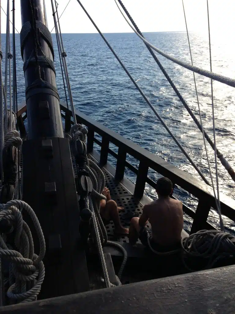
LIFE ON EL GALEON: AN ALMOST SPANISH SAILOR’S LOG
On May 10, 2016, El Galeon Andalusia maneuvered her majestic mast beneath the Cape Fear Memorial Bridge and returned to Port City Marina, what last summer’s crew called the tall ship’s “most successful port visit.”
Life at Sea
Indeed, record numbers of wannabe pirates, history buffs, and tall ship enthusiasts flocked to Pier 33 to tour the 170-foot replica of the 16th century Spanish galleon.
“We had more than 2000 visitors each of the 10 days we were there,” shared Chef David Garcia Gallardo, one of the Spanish crew. “And Port City Marina was very comfortable, with nice bathrooms!” he said, with a laugh. “This is important to sailors arriving in port!”
Incidents of rude, reckless powerboats have been reported for years now and most likely you have suffered much the same danger either in an anchorage or underway in the Waterway. Then again, you meet these same thoughtless, insane drivers on every Interstate. So…I do not have an answer other than to GRIN AND BEAR IT.
I was amazed at the amount of speedboats running thru the anchorage on plane. A constant parade on a Sunday afternoon. Many seemed to enjoy the sport of slaloming between anchored boats on half plane putting out big wakes. Then to my total amazement, a marine sheriff boat came thru, on half plane, and did nothing about the speed boats running thru here! They really don’t seem to care about basic safety and courtesy in Wrightsville beach. The cop must have been on his way to patrol the bathrooms. Ted
In many places local boaters feel they ‘own’ their waters and we transients are intruders. I anchor at Wrightsville a couple of weeks in the fall AND the spring. I spend money there at restaurants, food and hardware stores, etc. On some weekends there is standing two foot chop from wakes. As a catamaran we don’t roll but it sure is a little lumpy. I actually had a busy-body type lady tell me I should keep the free dinghy dock clear for local boaters. I had to quietly, calmly explain basic economics to her. Yes, we pay no property taxes, etc but neither do we cause wear and tear to the infrastructure or use their schools but we are paying plenty to service providers who DO pay taxes… but only as long as they stay in business. From we boaters.
This happens all the time in that area. This kind of boating does not happen just 10 miles south at the Carolina Beach boat basin. It is a no wake zone and people will remind anyone who makes a wake.
St. James Plantation Marina is on the Waterway’s northerly banks, about one nautical mile west of flashing daybeacon #16.
St James Marina, mm 315. Very friendly staff, quiet, protected marina, fuel, showers, laundry, excellent wi-fi, cafe/restaurant, “Tommy Thompsons”, and Enterprise will pick you up! A good place to hide, especially when the weather is bad. Bruce Franz s/v “Hemisphere Dancer” Dickerson 41
As Bruce Franz relates and Ms Wanda confirms, dredging at Alligator River Marina has been completed and invitations are extended to Spring Migrators! ARM lies on the western shore of the mouth of the Alligator River/AICW, just north of the swing bridge and southwest of flashing daybeacon #12. This facility provides the ONLY readily available dockage and fuel along the patch of the AICW between Coinjock, Elizabeth City and Dowry Creek/Belhaven!
Yesterday, proof positive our cruising friend’s 50 ft Gulfstar with a 6 ft draft can enter/leave Alligator Marina and visit Ms Wanda. Bruce Franz s/v “Hemisphere Dancer” Dickerson 41
This Special Notice was issued last year, /148804, and the latest issue serves to urge NC boaters to use extreme caution in the inlets listed below. Shoaling in the inlets may well mean shoaling in the intersection of the inlet with the Waterway. Pay particular attention to the NC Problem Stretches that involve these inlets: Bogue, Browns, New River, Carolina Beach, Lockwoods and Shalotte. Details of these Problem Stretches are found in the links below.
NC – HAZARDS OF NORTH CAROLINA COASTAL INLETS This notice is to notify mariners about accessing hazardous inlets, to heighten public awareness about the hazards that exist in and around the inlets, and to provide the mariner with available information. Mariners are advised that shoaling conditions exist at following North Carolina coastal inlets: Oregon Inlet Hatteras Inlet Ocracoke Inlet Barden Inlet Beaufort Inlet Bogue Inlet New River Inlet Topsail Inlet Masonboro Inlet Carolina Beach Inlet Lockwoods Folly Inlet Shallotte Inlet Shoaling conditions increase the potential for groundings. These inlets are subject to continual and sometimes rapid environmental changes. Mariners are highly encouraged to obtain the most recent U.S. Army Corps of Engineers Wilmington, North Carolina District hydrographic survey information, centerline waypoints and controlling depth at: http://www.saw.usace.army.mil/Missions/Navigation/HydrographicSurveys.aspx Mariners should use caution when navigating in these areas and passage through the inlets is not recommended without local knowledge of the area. The aids to navigation in these inlets may not be charted and may not be marking best water due to continually shifting shoals. Consult Local Notice to Mariners, 5th Coast Guard District for the latest positions and status of aids to navigation: http://www.navcen.uscg.gov/?pageName=lnmDistrict®ion=5 To report any aids to navigation discrepancies (missing, damaged, off station, extinguished lights), shoaling, hazards to navigation, or discrepancies on bridge lighting, please contact Sector North Carolina Command Center (910) 343-2200. LNM 17/16
The New Bern Grand Marina lies in the heart of downtown New Bern, North Carolina, along Trent River’s northern banks between the low-level Trent River highway and railroad bridges.
Welcome New Bern Grand Marina and Yacht Club Salty Southeast Cruisers’ Net welcomes aboard New Bern Grand Marina and Yacht Club as its newest Sponsor. We are honored to be able to connect cruisers and boaters with this outstanding destination up through the beautiful wooded areas surrounding the Neuse River off the Atlantic Intracoastal Waterway. Southern hospitality awaits you in this friendly riverfront town and the New Bern Grand Marina is your perfect host. Located in the heart of historic New Bern and within easy walking distance of shopping, dining and many historic sites that date back to its settlement in 1710, New Bern Grand Marina invites you to visit as a transient or to make this your home port with all the many outstanding amenities and even more if you become a slip owner/club member.
Bridge Pointe Marina flanks the southern banks of the Trent River off the Neuse River, opposite the downtown New Bern, NC waterfront.
BridgePointe Marina is the bomb! It’s been a year since I left Bridge Pointe Marina and I’m missing my time there. It’s a really well built and well managed marina with a nice bunch of boaters including some locals and liveaboards who will welcome you to Sunday night pot lucks. It’s also a very good place to leave a boat for the winter, as I did, and I also enjoyed the town of New Bern when I was around. Ben Ellison
A SALTY SOUTHEAST CRUISERS’ NET SPONSOR, Morehead City Yacht Basin, located on the southern flank of the marked channel that runs west from Mile 203 of the Waterway, just north of the Morehead-Beaufort, Newport River high-rise bridge.
The Yacht Basin was originally built in 1946. It started out as a pier and a building with an office, lounge with lockers, and a storage room. Around 1952, Bump Styron bought the Yacht Basin and added two piers. The Yacht Basin has always had close ties to the boating and fishing in Morehead City including the Big Rock Blue Marlin Tournament that started in 1957. Bump himself won the tournament in 1970 aboard the “Reel King”. Legend has it that even Ernest Hemmingway at one time fished for marlin out of the Yacht Basin. The Morehead City Yacht Basin has always been known for its customer service. James Hester, pictured below, greeted boaters for over fifty years and customers still come in and tell stories about his smiling, friendly service. Today the Morehead City Yacht Basin provides dockage both to slip owners, renters, and transients traveling up and down the ICW. With Mike Pollard as the head dockmaster for close to ten years the tradition of excellent customer service has continued. We have a very comfortable lounge for our guests and we are a short walk to over twenty great restaurants.
In 2014, Jet Matthews tripled the size of the Morehead City Yacht Basin with modern floating docks, 87 large interior slips, and over 1,250 feet of side tie dockage to accommodate vessels up to 200 ft with 30/50/100 amp power and 2 x 100 amp pedestals.
The intersection of the ICW and Lockwoods Folly has been a Problem Stretch for years and requires almost annual dredging. Recent reports confirm shoaling here, /154017. SSECN stills recommends Mid to high tide for passage through Lockwoods Folly. Kudos to Carolina Yacht Care for their nightly briefings on weather and navigation issues and our thanks to Hank Pomeranz for this report.
Hi Gentlemen, We’ve started our nightly briefs here at Southport covering the waterway north of here to MM 0. Hearing from a bunch of folks having problems with Lockwoods Folly ‘“ just south of Southport. Suggest reiterating that cruisers follow the marks carefully. G47, in particular, was just moved west and is very close to the shore. That said, mariners must follow it for plenty of deep water. Do not get sucked in to the R12 which will be to starboard for north bound cruisers. That is an inlet buoy. I don’t know if you can somehow share the attached image but you are welcome to use it. The depth legend for the USACE survey is shown and the depths represent MLLW. A pic is worth’¦ Regards to you all, Hank
This news of a boating course in Wilimngton, NC, as announced in StarNewsOnline, is good news for first time boaters.
WILMINGTON
Ned W. Rhodes, lead instructor with Cape Fear Sail & Power Squadron (right) poses with Capt. Doug Springer of Wilmington Water Tours. CONTRIBUTED PHOTO
New boating course a team effort Contributed article Published: Monday, April 18, 2016 at 11:16 a.m. NC_Wilmington –
Thanks to a recent fusion of resources from the Cape Fear Community College, Wilmington Water Tours LLC, and the Cape Fear Sail and Power Squadron, local boaters have access to a modern, comprehensive, shore- and water- based learning experience.
The program would not exist without all three players. CFCC has the superbly equipped, large, centrally located lecture spaces needed to accommodate three-times-a-year classes of 30 to 50 students participating in what is known as America’s Boating Course. Wilmington Water Tours operates the course’s `floating classroom,’ a catamaran named the Wilmington that can comfortably host up to 45 students at a time. The Cape Fear Sail and Power Squadron provides the certified experienced instructors, the practical expertise and the instructional materials needed to complete the effort.
The course begins in downtown Wilmington with a day of classes, capped by a state-sponsored certification test in CFCC’s Union Station building. The classes touch on all aspects of boating safety ‘“ including required equipment, basic boat handling, weather hazards, signals, lights and rules of the road ‘“ and practical tips drawn from the experiences of veteran instructors.
The next session of America’s Boating Course will begin on May 14th. For more information, see www.capefearboatingcourse.org.
BoatUS remains the premiere advocate for boaters and boating safety on all waters and SSECN is proud to have BoatUS as a SPONSOR!
(L) Capt. Lee Sykes receives the “Volunteer of the Year” award from (R) CCA NC Executive Director David Sneed.
NEWS From BoatUS Boat Owners Association of The United States 880 S. Pickett St., Alexandria, VA 22304 FOR IMMEDIATE RELEASE Press Contact: D. Scott Croft, 703-461-2864, SCroft@BoatUS.com
Coastal Conservation Association North Carolina Names TowBoatUS Capt. Lee Sykes Volunteer of the Year “Chapter Would Remain A Vibrant Voice for Coastal Fisheries Conservation”
RALEIGH, NC, April 18, 2016 – At its recent annual meeting, the State Board of Directors for the Coastal Conservation Association North Carolina (CCA NC) named local on water towing Captain and TowBoatUS Beaufort owner Lee Sykes “Volunteer of the Year.”
An advocate for coastal fisheries and owner of a local 24-hour on water recreational boat towing and assistance company, Sykes is the CCA NC President of the Crystal Coast Chapter and is credited with “Revitalizing this chapter and bringing it back as a significant contributor to our efforts in North Carolina,” said Chapter Member and CCA NC Board Member Bert Owens. The chapter is one of 13 in North Carolina. “He was determined that the Crystal Coast Chapter would remain a vibrant voice for coastal fisheries conservation in North Carolina.”
“I’m honored to have been selected,” Said Sykes. “I’m out on our waters nearly every day and believe that everyone needs to do their part. I’ve always wanted to ensure that my own child will continue to have a vibrant fishery for her generation, and our coastal waters continue to provide a quality fishing experience that doesn’t diminish.”
Part of a nationwide network of 300 locations and over 600 towboats, Sykes’ TowBoatUS business is North Carolina’s largest, providing 24-hour on water towing assistance and soft ungrounding services to recreational boaters, much like a reliable auto club. It also offers salvage services. In addition to Beaufort, Sykes’ additional TowBoatUS locations include Swansboro, Jordon Lake, Falls Lake, Sharon Harris Lake, Gaston Lake, Kerr Lake, Smith Mountain Lake VA, and most recently High Rock Lake. For more visit BoatUS.com/beaufort.
CCA and its state-chapter network are engaged in hundreds of local, state and national programs and projects related to marine conservation, including initiating scientific studies, funding marine science scholarships, building artificial reefs, creating finfish hatcheries, initiating hydrologic and contaminant studies, monitoring the quality and quantity of freshwater inflows, supporting local marine law enforcement and more. For more visit www.ccanc.org.
About TowBoatUS: Celebrating 50 years in 2016, Boat Owners Association of The United States (BoatUS) is the nation’s leading advocate, services and safety group for recreational boaters. We provide our over half-million members with a wide array of helpful services, including 24-hour on water towing that gets you safely home when your boat won’t, will bring you fuel if you run out, jumpstart your dead battery, or provide a gentle pull after you’ve run aground. The TowBoatUS towing fleet is North America’s largest network of towing ports with over 300 locations and over 600 towing assistance vessels, responding to over 70,000 requests for assistance each year. For more information go to BoatUS.com/towing.
Port City Marina, A SALTY SOUTHEAST CRUISERS’ NET SPONSOR and newly opened for business, is located along the eastern banks of the Cape Fear River, in the heart of downtown Wilmington, NC.
“Slip into Somewhere More Comfortable” The Port City Marina is a protected, deep water, full-service marina in Wilmington, North Carolina with over 200 state-of-the-art floating concrete wet slips and a full complement of first-class amenities situated in the heart of downtown. You can walk to restaurants, check out the thriving downtown art scene, or explore the boutique shops. Convenience at its finest.
SALTY SOUTHEAST CRUISERS’ NET is proud to welcome our newest sponsor, Curtis Stokes and Associates of North Carolina.
Historic Edenton, also A SALTY SOUTHEAST CRUISERS’ NET SPONSOR, is 300 Years Young! Come and let them prove it!
Curtis Stokes & Associates presents “Journey”….
At Curtis Stokes & Associates, we specialize in marketing some of the finest vessels available in the Southeast. Located in Jacksonville, NC, “Journey” is a prime example. She is a classic 2006 36′ Monk Double Cabin trawler whose experienced owner has maintained her in turn-key condition and is willing to assist the buyer with delivery and – or training. Get a complete description and view a video of this beautiful boat here: http://www.curtisstokes.net/trawler-for-sale-monk36-journey.html.
For more information or to schedule an appointment to view “Journey” please call Wayne Smith in Edenton, NC, at 516-445-1932 or you can email him at wayne@curtisstokes.net.
Our customers know they can come to Curtis Stokes & Associates to find some of the most seaworthy yachts on the market today. If you have a boat to sell, find out how we can market your vessel not just here in the Southeast but throughout the country and in overseas markets as well. And if you’re in the market for a boat, find out about our buyer broker service here: http://www.curtisstokes.net/yacht-buyer-brokerage-service.html. To view our complete inventory of fine yachts visit us at www.curtisstokes.net


Comments from Cruisers (1)
Lockwoods Folly passing is no problem at this time! Just follow the markers as they move from time to time. If you want to be extra cautious travel through on a rising tide.