NOAA Navigation Services Newsletter – July 2022
|
|
Officially “The Friendly City,” Bradenton is a vibrant city located along the Gulf Coast in Manatee County in the US State of Florida.
Click here for more information: Bradenton, FL
WorldAtlas.com
AREA SPONSORING MARINAS
Click Here To View the Western Florida Cruisers Net Marina Directory Listing For Twin Dolphin Marina
Click Here To Open A Chart View Window, Zoomed To the Location of Twin Dolphin Marina
Click Here To Open A Chart View Window, Zoomed To the Location of Riviera Dunes Marina Resort
Cruisers Net lists only one marina, Four Winds Marina, suitable for drafts less then 3.5ft, at the northern tip of Pine Island. However, there are several good depth anchorages at the southern tip of the island just north of the Caloosahatchee River and the Okeechobee Waterway.
Of the entire US, Pine Island is the 118th largest island and resides in Florida’s Lee County, which is west of Cape Coral. Pine Island is a part of a chain of islands that constitute the Matlacha Pass and separates it from the Florida Mainland. On the west side of Pine Island reside the Intracoastal Waterway, a waterway that runs from Massachusetts to Texas, passing around the Florida Peninsula. Of the nearby islands, Sanibel Island lies to the south, North Captiva Island to the west, and Captiva Island to the southwest.
Similar to nearby Fort Myers, Pine Island is made up of deposits of coral rock. This variation of limestone encrusted with fossilized shells, animals, and even pine trees found in the northern tip from the excavation is common throughout southern Florida. Following millions of years of North America settling into place from the continental drift, that state’s land mass was twice as large. This saw extensive forests, dunes, and tributaries with the coast of the Gulf of Mexico starting another 100 miles west of Pine Island. Thus, came the ice age, which brought forth flooding as the glacier defrosted. Around 4500 BC, the shape of Florida formed into something similar to today. The former ice age also increased water levels and created the long and narrow islands seen off the gulf coast, including Pine Island. With churning ocean water, channels, shoals, and the unnamed sand beaches that are a familiar attraction of Pine Island formed. However, the mingling of freshwater and saltwater from the tributaries’ output created sedimentation. The fallen trees from the shore, among shells, animals, and other items fossilized in this sedimentation, created the limestone, better known as coral rock.
Long before the town of Pine Island existed, the Calusa Indians were the first known inhabitants of this island, around 800 AD. The first contact with outsiders did not occur until the mid-16th century when Spanish conquistadors landed. By the 19th century, there were no further documented occurrences of the Calusa Indians, and it is believed the tribe could have died off or dissolved into other tribes. Ongoing research is being conducted on Pine Island to further understand the Calusa Indians, with artifacts being unearthed as of today.
Construction of wind turbines off the North Carolina coast could affect birds and marine life, and while scientists and others seek more information on the extent of those effects, those who spoke during a forum last week in Wilmington said climate change is likely a greater threat.
Offshore wind turbine impacts a trade-off, panelists say
CoastalReviewOnline.org
In addition, the nucs provide power 24/7.
The article states that "The Kitty Hawk WEA and Wilmington East WEA are under lease. These areas have the combined potential to generate upwards of 4 gigawatts of power, the equivalent output of four nuclear power plants." That is not really factually accurate when comparing apples to apples.
It is true that the nameplate capacity of the wind farm and four nuclear plants are both 4 gigawatts. But the capacity factor of a nuclear power plant ( the amount of power it actually produces compared to the nameplate capacity) is 90%. So 4 nuclear plants are capable of producing 3.6 gigawatts of power 24/7, 365 days a year. The average capacity factor of an off shore wind turbine is 45%. So the off shore wind farm is capable of producing 1.8 gigawatts of power 24/7, 365 days a year. A good amount of power for sure, but only the equivalent of 2 typical nuclear plants.
Ancient mariners used to gauge how fast their ship was moving by throwing a piece of wood or other floatable object over the vessel’s bow then counting the amount of time that elapsed before its stern passed the object.
Why is a ship’s speed measured in knots?
history.com
Biologists race to learn what it is and maybe how to thwart it.
Mystery disease is killing Caribbean corals
ScienceNews for Students
In the ocean off southwest England, cold-water kelp is being replaced by a warm-water species, with profound effects for the local ecosystem.
The Surprising Consequences of a Seaweed Switcheroo
Hakai Magazine by Rebecca Dzombak
Our long history of constraining the river through levees has led to massive land loss in its delta. Can we engineer our way out? And at what cost?
The Controversial Plan to Unleash the Mississippi by Boyce Upholt
Hakai Magazine
The Friends of John Pennekamp Coral Reef State Park and Dagny Johnson Key Largo Hammock Botanical State Park are taking this famous sentiment one step further – by installing a state-of-the-art coral camera to showcase what lives in our waters.
The Coral Cam presents a beautiful undersea vista. CONTRIBUTED
NEW PENNEKAMP STATE PARK CORAL CAM GIVES A VIEW INTO THE BLUE – Florida
Keys Weekly
Click Here To View the Cruisers Net Florida Keys Marina Directory Listing For John Pennekamp Marina
Click Here To Open A Chart View Window, Zoomed To the Location of Largo Sound
A new exhibit at the Graveyard of the Atlantic Museum reminds us that a vicious German U-boat campaign in the early months of World War II had once raged offshore the barrier islands, setting the sea ablaze and filling the air with explosions.
A simulated view through a submarine’s periscope is included in the new exhibit at the Graveyard of the Atlantic Museum. Photo: Catherine Kozak
U-boat artifacts, divers reveal history of Torpedo Junction by Catherine Kozak
CoastalReview.org
The nautilus’s lineage made it through all five of Earth’s previous mass extinctions. But can it survive the Anthropocene?
A tentacled fuzzy nautilus swims in the deep waters off the coast of Papua New Guinea. Though the nautilus is well known in some ways, it’s also mysterious; researchers studying it hope to get a handle on how it’s responding to impacts of the Anthropocene. Photo by Peter Ward
Ancient Nautilus, Uncertain Future
Hakai Magazine
Cruisers Net publishes Loose Cannon articles with Captain Swanson’s permission in hopes mariners with salt water in their veins will subscribe.. $5 a month or $42 for the year and you may cancel at anytime.
Florida To Launch ‘At Risk’ Vessel Turn-In Program
Peter Swanson
Along with Watch and Warning designations, these alphabetical listings, Whiskey, X-ray, Yankee and Zulu, are used to indicate the anticipated severity of an approaching storm. And while the port restrictions are directed primarily at commercial traffic, the same port conditions allow recreational boaters to gauge the level of risk from the storm. Obviously, the further along the alphabet, the more severe the forecast for a given port or coastline. The official hurricane season is from June 1 to November 30.
HURRICANE SEASON PORT CONDITIONS AND CATEGORIES
Port Conditions are set by the Captain of the Port and are used to alert the maritime community to changes in port operations needed to prepare for the storm’s arrival.
PORT CONDITION WHISKEY: Gale force winds (34 knots or 39 mph) are predicted to arrive within 72 hours. Port Status: Open to all commercial and recreational traffic.
PORT CONDITION X-RAY: Gale force winds are predicted to arrive within 48 hours. Port Status: Open to all commercial and recreational traffic.
PORT CONDITION YANKEE: Gale force winds are predicted to arrive within 24 hours. Port status: Closed to inbound traffic and vessel traffic control measures in effect on vessel movements within the port.
PORT CONDITION ZULU: Gale force winds are predicted to arrive within 12 hours. Port Status: Closed to all inbound and outbound traffic.
PORT CONDITION RECOVERY: The storm is no longer a threat to the area, however, some damage may have occurred and response and recovery operations are in progress. Port status: Reopened to outbound traffic at the completion of the port survey. Vessel traffic control measures remain in effect on vessel movements within the port.
In Rochester, New York, a little wooden box lay forgotten on an estate table sale; a knickknack bought by a Florida tourist more than a century ago.
A souvenir box made in Mauchline, Scotland, depicts a banyan tree on Pitts Island, now known as Munyon Island, near North Palm Beach. That’s Singer Island beyond. PHOTO BY GINGER L. PEDERSEN
A souvenir of Florida’s nearly forgotten past
Ginger L. Pedersen for Palm Beach Florida Weekly
Although focused on maritime workers, this safety guide has ideas for use on private vessels.
Maritime Safety Guide
Lanier Law Firm
Our sincerest thanks to Greg and Barbara Allard for once again sharing their thoughts and beautiful photography from their Bahamas cruises. These photos and descriptions will have you aching to follow in Meander‘s wake! For more this excellent photography, type Allard in our Homepage search window for letters from previous cruises.
Hello Everyone – Here is our second Letter from the Bahamas for 2022.
Several of you did not receive the photos with the last Letter. It may have to do with the capacity of local internet service; if you do not receive the photos, please let us know.
This from a recent news report from the Bahamas:
“He said as he approached Grand Bahama, he realized his fuel was almost empty and immediately knew he was in “problems.”
-Andrew Rolle, a Bahamian, upon being rescued after several days at sea, when he ran out of fuel.”
It is a rare cruiser to the Bahamas who doesn’t at some point realize that he is “in problems”, an appropriate Bahamian expression if there ever was one. Stuff on boats always seems to fail no matter how much rigorous preventative maintenance has been done. The worst situation is breaking down while in the open ocean.
This young Bahamian, Stephen, found himself “in problems”. Fortunately he was not far from help. While in our dinghy, we came upon him in his disabled boat – the outboard motor would not run. We took his boat in tow, and learned that he was from a fishing boat named My Rebecca from Nassau, and they were going for conch. They hoped to take 7,000 conch to market.
A couple of days later, at the mouth of the entrance cut into the harbor, we saw the fishing boat Stephen was working on, anchored with the stern placed in very shallow water near some rocks – a strange place to anchor. We went over, and Stephen explained to us that the propellor shaft on the boat, which connects the engine and goes through the bottom of the boat to the propeller, had broken. They had ordered and received a new shaft, and they installed it, which explains why the aft end of the boat was in shallow water – to allow them to pull the shaft out of the boat while the crew was standing on the shallow sandy bottom. When they installed the new shaft, they found it was too short, so they were waiting for a shaft extender piece to arrive. Incredibly resourceful.
Five fishermen live on this boat. They had their laundry out to dry.
Yet again, a few days later, we found My Rebecca tied up at the government dock. The man in the red shirt is the diver – he is the one who retrieves the conch from the bottom, breathing compressed air from a pump on the surface. Stephen Sands, whom we towed in, is in the rear of the small boat.
Stephen wasn’t so anxious to have his picture taken but eventually agreed. On his arms were tattoos with the names of his three children: Stephenelle, Stephenique and Stephanos. In the rear pocket of his jeans was a flask of something, likely needed to survive on the cramped quarters of the old fishing boat.
In our last letter, you met Alvin, who found a perfect hose for a repair on our boat. This is Alvin’s son Quincy – Alvin’s second youngest of his nine children. Quincy has a full row of beautiful gold teeth on top. He is a smart, affable young man with a good sense of humor. He has solid experience around the water, which shows as he assists boats entering the marina, and helps them to safely and securely dock their boats – which is quite an art. A bad dock-hand can cause damage to a boat in an instant. Quincy just had a new daughter in Nassau, and he flew there this week to see her for the first time. This highlights one of the realities of the Bahamian economy – many families are split when (usually) the father has to travel to a distant island for work. Moving between islands is expensive – usually by local small aircraft.
We explored the sand flats off the west side of Great Harbour Cay. The water is shallow, especially at low tide, and there is much wildlife: sting rays, fish, conch and juvenile black-tip sharks about 2-3’ long. Barbara is in the dinghy behind me. Our friends who were with us said that they wondered if she was paddling away…
This year there was an abundance of these beautiful Cushion Sea Stars, which can grow up to 20” across. It has a thick body and knobby spines which form geometric designs. Some are tan; this one is orange-brown. We don’t keep them and it was returned to the water.
One of our favorite adventures while at Great Harbour is to do a “dinghy expedition” a number of miles south to an island called Money Cay. Legend has it that a hermit found a trove of money there, years ago. The entire area has to be one of the most spectacular places on earth. Pristine beaches, sparkling water and total solitude. One day we saw a local fishing boat there, but the majority of time we are totally alone.
It’s a bit of a challenge to reach Money Cay – you can go there only on the top half of the tides over the sand flats. Otherwise there is barely enough water to float the dinghies, let alone run them at any speed.
In this photo, our friends Jim and Ellen have just explored a secluded bay. The water under their dinghy is about 12’ deep. Both of our dinghies are equipped with bimini tops to provide shade from the Bahamian sun.
Here is a Queen Conch, with the most exceptional range of colors we have seen. This one is live – you can see the little critter poking out. We took its picture and returned it to the water.
This is the same Queen Conch as shown in the prior photo, and how it looks in its normal place on the bottom. The sea growth on the top of the outer shell serves as camouflage, making it difficult for most predators to find them. They use a big single claw to drag themselves across the bottom looking for food.
One day while exploring some remote islands, we spotted this bonefishing boat in the distance. The man standing on the platform at the rear of the boat is Percy Darville, one of the most famous bonefish guides in the Bahamas. He is 69 years old, and has served as guide to Jack Nicklaus, who has been a regular at Great Harbour.
Percy is using a long pole to push the boat through the flats while his client, standing in the bow, scans the water for the elusive fish. Bonefish are between 1′ to 2 1/2’ long and live in the shallows; they are considered a premier gamefish, and give the angler an extraordinary fight. It has been said that if a bonefish were as big as a battleship, it would take a battleship to land it. All bonefish are returned to the water, both out of sportsmanship and since they are difficult to eat because of……
Barbara anchors the dinghy, ready to explore a new cay we just landed upon.
Since our first letter, we have received several questions about how the Bahamas may have changed, post pandemic. Masks are to be worn any time you are inside (except while eating), and it is enforced. We met one cruiser who was asked to leave a food store because he had no mask. All of the dockhands, even outside, are masked.
Diesel fuel at our marina is now around $7.50 a gallon, about average for the Bahamas.
There is a good deal of construction going on here, mostly higher-end vacation homes for foreigners. But the economic downturn and possible recession have appeared to put many of those plans on hold.
There aren’t really food shortages, just gaps in time as to when the food is available. The mail boat came in again yesterday (on-time two weeks in a row) so the stores should be re-stocked by now. Few are going hungry but people often run short of things they would need.
While cruising on a boat, approaching storms may soon get you “in problems.” But it’s all worth it to be in such a beautiful country.
_____________________________________________________________________
“The true meaning of life is to plant trees, under whose shade you do not expect to sit.” – Nelson Henderson
Best regards to you all.
Greg and Barbara
Copyright Greg Allard, 2022
Final 5/20/22
Our sincerest thanks to Greg and Barbara Allard for once again sharing their thoughts and beautiful photography from their Bahamas cruises. These photos and descriptions will have you aching to follow in Meander‘s wake! For more this excellent photography, type Allard in our Homepage search window for letters from previous cruises.
When all else fails, try journalism.
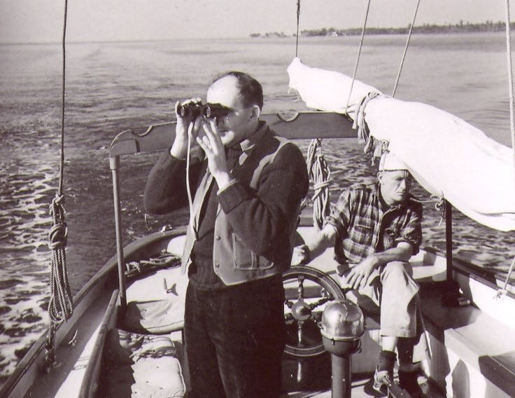
ANSEL ADAMS SCANS THE HORIZON on a 1940 trip down the Intracoastal Waterway. The great photographer took about 50 pictures that we cannot see, though we may see some photos of him taking the photos we cannot see. Traumatic events mark the beginning and end of every American epoch. Their names begin with words like “pre-war, “post-war,” “pre-911,” “post-911” and, most recently, “pre-covid.” (Here’s hoping for “post-covid.”) The Atlantic Intracoastal Waterway is a national treasure. Once the purview of barges and other commercial traffic, the ICW extends 1,100 miles from Virginia to Key West, Florida, man-made canals linking a collection of inlets, rivers, bays and sounds. Quite accidentally, the great American landscape photographer Ansel Adams documented the ICW one year before the Japanese attack at Pearl Harbor launched American involvement in World War II, a national trauma that changed everything. Adams photos depict an ICW at a moment before the deluge. Thereafter, as the generation that won the war ventured out in small craft, the character of the ICW transitioned from commercial to recreational. By autumn 1940 Adams was well established as landscape photographer, though another year would pass before he would shoot his most famous photo of all, Moonrise, Hernandez, New Mexico. As with many of us, Adams was drawn to his first boating adventure by the contagious enthusiasm of a good friend. The California native was convinced to go on a spur-of-the-moment cruise of the ICW aboard the schooner Billy Bones II. Naturally, he took pictures, which inadvertently documented the end of an era, but, because of draconian copyright enforcement, the collection won’t be available for viewing until 2054, 70 years after Adams’ death. Adams was friends with painter Georgia O’Keeffe, another artist reknown for Western imagery. In 1936, she introduced him to her friend David McAlpin, a photography enthusiast and trustee of the Museum of Modern Art in New York City. McAlpin was an investment banker credited with a key role in establishing photography as fine art, a goal he encouraged with donations from his personal fortune. He was also to become a patron and lifelong friend to Adams. In 1937 and ’38, the two went on camping trips to the western sierras, decidedly Adams’ home turf. You could look at their Intracoastal Waterway jaunt as a reciprocal gesture, roughing it in the style of the East Coast elite. Biographers say Adams was near the peak of his game by 1940 when McAlpin involved the 38-year-old pianist-turned-photographer in his campaign to establish a new photo department at New York’s Museum of Modern Art. “In November, having finished the first phase in setting MOMA’s new department, McAlpin suggested to Adams that they take a break to take a Thanksgiving holiday cruise,” Stephen Jareckie wrote 66 years later. Jareckie was curator of the exhibit of photos from the trip, displayed at the Fitchburg (Massachusetts) Museum of Art in 2007 and later at the Museum of the Albemarle in Elizabeth City, N.C., where Billy Bones II had stopped for fuel after the Dismal Swamp. “Ansel Adams in the East” featured 50 prints made from proofs found in the estate of McAlpin’s second wife.
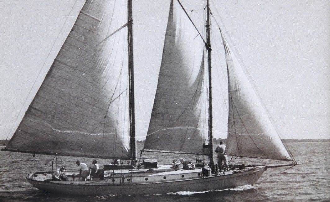
The Billy Bones II was a 43-foot schooner built in 1929 in Fairhaven, Massachusetts, a copy of a John Alden design. The captain of Billy Bones II was the late John DePeyster Stagg, a larger-than-life character on the Long Island waterfront. Stagg, 26 at the time, was a charter boat captain with all the right stuff; he was a storyteller, a fine drinking partner and with a reputation for wizardry in the galley. Billy Bones was a reference to the enigmatic, hard-drinking old salt introduced at the beginning of “Treasure Island” by Robert Louis Stevenson—and a clue to young Stagg’s outlook on life. Stagg was always threatening to write a book: “Staggering with Stagg from Maine to Florida, a Guide to the Better Bars.” The Bones, 42-feet LOA, had been built in 1929 by the Casey Boatbuilding Company of Fairhaven, Massachusetts, which basically capied of John Alden’s Malabar V right down to her Scripps gasoline engine. Stagg bought her second-hand, renamed her Billy Bones II and put her to work in the charter trade, taking guests on trips along the East Coast and in the Bahamas. Unusually for her time and type, she had two heads. David Hunter McAlpin had inhaled the briny air while serving as an ensign on a Navy subchaser during World War I. By the 1930s, he had become a partner at Clark Dodge & Co. investment bankers. McAlpin and Stagg knew each other because Stagg had some money invested with the firm, and both were from established New York families. Stagg was a descendant of George Washington’s aide at Valley Forge, and McAlpin’s family status had allowed him to marry into the Rockefellers. Adams had a reputation for working hard, playing hard and enjoying strong drink. McAlpin’s pitch must have had tremendous appeal—the idea of Huck Finning it down the waterway on a schooner! Adams and McAlpin caught up with the Billy Bones II in Norfolk, Va., joining Stagg and his crew, a professional sailor named Winfield Scott, known to everyone as Scottie.
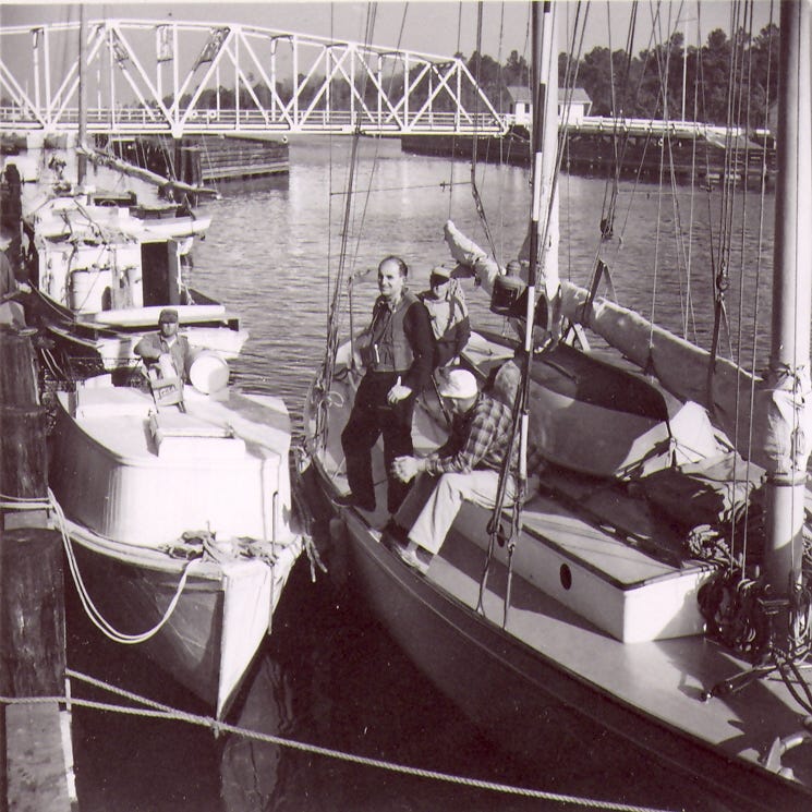
 Thanksgiving, Nov. 21, 1940, found Billy Bones II in the Dismal Swamp and John Stagg in the galley cooking turkey. Curator Jareckie wrote, “Adams and McAlpin took pictures of the tree-bordered canal. Adams discovered unexpected beauty in the Great Dismal Swamp.” (One wonders whether Stagg, like other schooner chefs before him, had to break the turkey’s backbone, squashing it to fit it in the ship’s oven.) Schooner and crew continued motoring on the ICW to Thunderbolt, near Savannah, where Adams and McAlpin bid goodbye after 10 days and 580 miles together. A tripod is useless aboard a boat, so taking his usual glass-plate camera would have been silly. Adams and McAlpin shared a new Zeiss Super Ikonta BX camera, a bellows-camera that folded and closed into compact package when not in use. Images were recorded on a big 2¼-inch-square negative. The museum exhibit images were made from 5-by-5-inch proofs, unimproved by darkroom printmaking techniques that were also part of Adams’ artistry. Today’s story is free to all subscribers. For access to everything by Loose Cannon, move up to a paid subscription. It ain’t a lot of money. Today’s photographers process their finished works with Photoshop, but during the era of film and glass plates, the great shooters achieved some of the same effects using “dodge and burn” techniques to manipulate the light as it was projected through a negative onto photo-sensitive paper. As I recall, the pictures Adams and McAlpin took on their 1940 voyage contain no stunners, nothing as dramatic as Adam’s western landscapes; no “Moonrise” or “The Tetons, Snake River.” To a journalist, however, the Adams photos have a familiar feel. With only basic equipment and moving aboard a boat on a delivery schedule through unfamiliar territory, Adams adjusted his approach. The fine-art photographer became a documentarian.
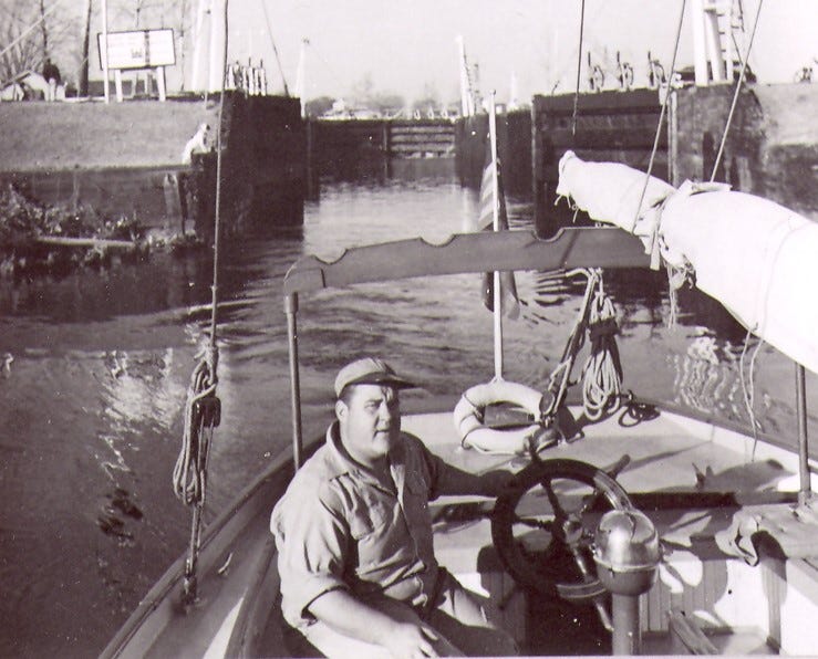
Skipper John Stagg, a larger-than-life character, takes Billy Bones II through the locks at the southern end of the Dismal Swamp Canal. 
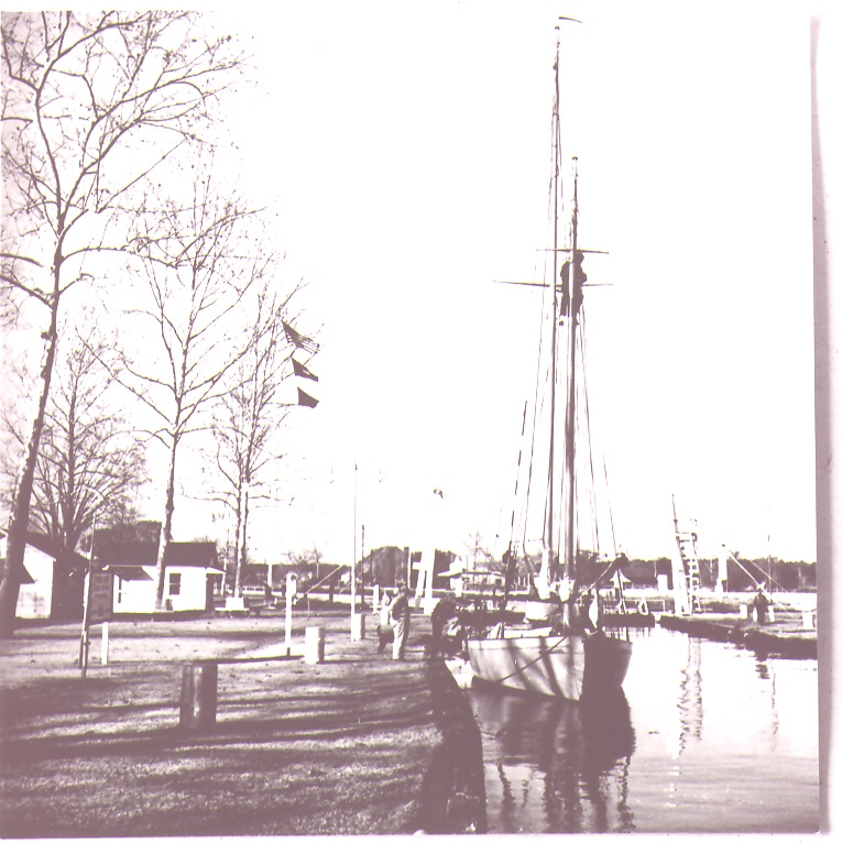
The photos indeed show the crew together and individually as any vacation collection would. They show the Dismal Swamp, canal locks, a swing bridge, docks and fishing boats. Commentators who saw the museum prints described the body of work as “vacation snapshots.” To be fair, however, it should be noted that Adams was working it pretty hard, scooching low for some compositions, going high for others. In fact, Adams at one point climbed the mainmast to fill his frame vertically in the face of a flat Carolina landscape. The docks Adams snapped are the rough-hewn province of fishing boats, not the pleasure craft that would arrive in 1950s. The barrier islands of the Carolinas would have been largely free of beach houses. Hilton Head hadn’t happened either. Instead, a boatman was captured rowing by the light of dawn at Thunderbolt, an image that could just as well have been painted in oils. We see the Annie D. Bell, a Chesapeake Bay lumber schooner under sail. Describing an image labeled “Fort Sumter, Carolina, on horizon,” one critic wrote, “The fortifications…emerge as the merest bump off in the distance. Dominating the picture are long tendrils of cirrus that seem to converge on the far-off island, like arrows—or accusations.” In another shot, Adams experimented looking for abstract imagery in the shape of the boat’s wake.
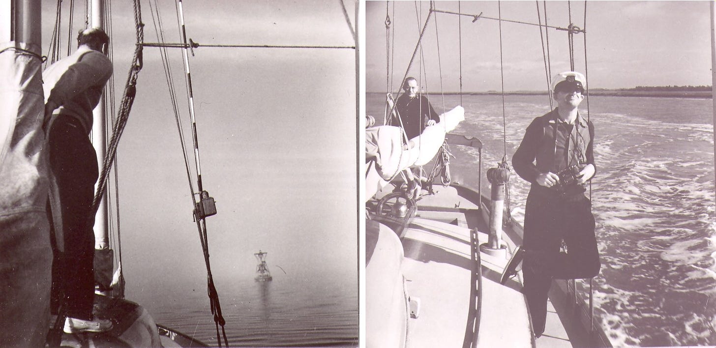
 Historical significance and craftsmanship notwithstanding, the trustees of the Ansel Adams Publishing Rights Trust in Mill Valley, California, criticized the Fitchburg exhibit and claimed that Adams himself would have objected to such a display of his work. The ICW shots, trustees argued, are mere proofs. All the famous Adams photographs had been refined by the photographer’s masterful darkroom techniques. Adams, the trustees said, would never have approved an exhibition of raw proofs. “I think it’s unethical in terms of museum ethics and behavior. It’s something that never would be done at MOMA or the Art Institute of Chicago,” William Turnage, one of three Adams’ trustees, told the Associated Press. “But you know, what the heck? Some people are going to take advantage and try to profiteer, and there’s nothing we can do about it.” After the outbreak of war, McAlpin rejoined the navy as a commander and used his business expertise on behalf of the government to monitor shipbuilding contracts. Adams greatest wartime contribution was journalistic in nature as he documented life at Japanese-American internment camp at Manzanar, California. Once exhibited, this collection was subtitled “Suffering under a great injustice.” The artist and the enthusiast remained friends for life; Adams died in 1984, McAlpin in ’85. Stagg crossed the bar that same year. Stagg sold Billy Bones II in 1942. The U-boat menace had sunk his charter business. The buyer was a Charles Foster (most likely the same Marblehead yachtsman and hotelier known for owning more than 60 pleasure boats during his lifetime). During the war, Stagg went to work for the Thomas Knutson boatyard, helping to build 110-foot submarine chasers for the Navy. The Adams trust justified its censorship by asking whether anyone would really be interested in the exhibit had someone other than Adams shot the photos. I would rephrase the question: Why should Americans be prevented from seeing these images just because Adams was the photographer? These photos show us a slice of waterway history. And they are proof of how a boating lifestyle connects us with nature and nurtures lifelong bonds of friendship and memory. Stories You Might Have Missed Without a Paid SubscriptionHighway to Hell: Autopilot Assisted Disaster; Two Examples of What Happens When Available Tools Go Unused Bad-Faith Enforcement of Derelict-Boat Law, Two Examples: (Click to sign up and read.) This post is only for paid subscribers of LOOSE CANNON. © 2022 Rio Charters Unsubscribe |
Washington County’s story is one of isolation, success, and an eventual renewal on the banks of the Roanoke River.
Plymouth Postcard. Source: UNC Libraries
Quiet Washington County rich in coastal NC history by Eric Medlin
CoastalReview.org
Our lives depend on the ocean. “Our Blue Planet” helps remind us how important a healthy ocean is to all life and highlights NOAA’s mission to protect and explore it.
|
Be the first to comment!