If you have any interest at all in boat building, or just messing about in boats, then this article is for you. Thank you Capt. Wheeler.
SPARRING WITH MOTHER NATURE ~~ latest addition! Settle back for your Sunday Morning Read. I’m so honored that you’re following along. Thank you.
Please enjoy the latest passages from STEADFAST. As of August 1st, 2024 we are undergoing extensive repair and refit and will be for several months. In boating terms we are hauled out “on the hard.” I plan to mix Sailing Stories with the challenges and intricacies of restoring a 90-year-old Sailing Yacht. I’m always open to suggestions as to content….please feel free to weigh in. Thank you. J
Boatbuilder Duncan Macfarlane has an old soul. Alive for just under four decades, he prefers music recorded prior to his birth and reveres vessels built long before that. His passion for wooden boats is so strong, in fact, that he’s made it his life’s work to bring them back to what they once were. Back to what they should be. Back to what their designers wanted them to be, and maybe, just maybe, one shade better. On his first day I said to him, “My father always told me, ‘Measure twice, cut once.’ Is that your Mantra?” He looked at me steadily and replied with just a touch of levity. “Oh no. We measure many times.”
In this photographic essay, Duncan fits the knee, (which you can see being shaped in the post MORE PRECIOUS COMMODITIES), recreates the stem, (or very front) of STEADFAST, and attaches the two together, preparing for installation. The new Purpleheart is a stark and startling contrast to the century-old materials it is replacing and supporting.
This is the knee, which attaches the stem to the forekeel, or bottom, of the vessel. What a contrast to the original oak. We want it to last another 90 years! The final photo is the view from inside.
Duncan trims our PRECIOUS COMMODITIES down to size prior to the final shaping of the larger new component, the stem.
Patterns were created from the removed damaged stem as well as from the original 1934 William Hand Jr. designs, which we obtained from the Massachusetts Institute of Technology’s collection.
The rectangular inlay is called a Dutchman and is used to eliminate an unwanted quality in the lumber. Everything Duncan does has that level of detail.
When the Purpleheart is cut, the color comes alive. I call this Duncan’s Purple World.
He spent hours lofting, which is laying out the plans to scale, and he spends more hours making sure the new fit is perfect, adjusting as he goes.
Tools of the trade range from the rudimentary to the advanced, and it is the attention to detail that will pay off in the end.
STEADFAST’S two new components are fit together for the first time and holes are drilled for the long custom bronze bolts that will hold them together. You can see the seam where the knee and the stem come together.
This precise work requires a bit of guidance, a bit of strength and a hell of a drill bit. The curve that you see here will eventually be what is commonly referred to as the bow.
The holes drilled are precisely the same size as the bronze bolts and it takes some brawn to pound them through the tough tropical hardwood. Tar seals the seam, and there is a ‘key’ (the small block of wood between the stem and the knee) ensuring that everything fits just as it should.
This may be the last week we can see outside from the inside. It is truly a disconcerting view.
The apparatus is in place to install the half-ton of meticulously recreated replacement components, giving STEADFAST back her shape. Progress indeed! Duncan is on the right, owner Steve Uhthoff is on the left.
The ancient art of shipbuilding is, like many ancient arts, becoming more and more rare, as are boatbuilders themselves. It was determined a few decades ago that other materials lasted longer and were far easier to maintain. Progress? That, of course, is a matter of opinion. Regardless, what an opportunity it is to see how complex, intricate, interdependent and STEADFAST vessels such as this one really are. Thanks for following along as we complete the painstaking and joyful repair and refit of our floating home. There are many more steps to come!!
Your input is appreciated and welcome! Love wooden boats? Build them? Never seen one? People certainly fall into all these categories. Like our Boatbuilder himself, STEADFAST most certainly has an old soul, in more ways than one.
*** I will always keep the articles I have written available for free to my readers. If you see value and possess the means, it’s great encouragement to have paid subscribers. If not, simply ‘liking,’ commenting, restacking and sharing these tales helps spread the word about me and what I have chosen to do. There should be someone on your email list that would be intrigued! Sharing is caring.
Most importantly, YOU, MY READERS, ARE TREMENDOUSLY APPRECIATED!
And lastly: our weekly sunrise. These can be seen on Facebook YACHTING STEADFAST each and every morning until 2025.
A Deadrise Workboat goes out at dawn in the last month of the Blue Crab Season here on the Chesapeake Bay. Miss STEADFAST is the two masts on the right, hauled out at Yacht Maintenance Co. in Cambridge, Maryland.
A resplendently restored Chris Craft lording over her neighbors in Bristol, RI
The author is a NAMS Certified Marine Surveyor with an office in Marblehead, Massachusetts. His firm specializes in accident investigation, failure analysis, and expert consulting. This article was originally published in the now-defunct Professional BoatBuilder magazine.
By JONATHAN KLOPMAN
Despite breathless press coverage, the crusade for “carbon neutral boating” seems to be losing steam. Whether it is cost, a lack of viable “clean” watercraft, or the public’s recognition that putting around in a battery powered launch would get old quick, I just don’t see any sign that the green revolution in recreational boating that for the past 10 years was “just over the horizon” is steaming into view.
Even though I have a deep affection for internal-combustion engines, that doesn’t mean I am oblivious to the environmental waste in our industry. I see our impact, but as we look at strategies to reduce it, I fear we are missing the forest for the trees. Pleasure boating, in terms of hours of use per season, has been on the decline for decades.
Recent studies peg it at less than 50 hours per year, which means that a BMW X5 with conservation plates and a “The Earth is our Mother” bumper sticker burns far more gas in a year than the average recreational powerboat.
So, what are we missing? Acknowledging that a boat’s power plant is surrounded by more than a ton of cured polyester resin is a big start. While the enlightened in our industry wring their hands over developing efficient electric propulsion driven by combustible lithium batteries, most of them have no compunction about chopping up thousands of viable hulls every year.
There are landfills choked with the skeletons of once proud marques—Hatteras, Bertram, Chris Craft, C&C, Bristol, Pearson. Where are the planet-conscious clean-boating advocates to speak out about this desecration?
The kneejerk answer is that it is simply too expensive to refit older vessels. A quick look at the staggering purchase price of new boats quickly disproves that. The problem is far deeper. While boat restoration is expensive, the real challenge these days is finding a yard that can provide the services ands skills required to meet the task.
I have always been proud and grateful for having worked at Graves Yacht Yard, Little Harbor, and the Marblehead Trading Company in Massachusetts. The collaborative effort of being part of a team of committed craftsmen is what convinced me to spend the rest of my working life in the boat business.
The traditional “full service” yard is fast becoming history. Without ambitious projects, yards stagnate and lose skilled crew. Not so many years ago, well-heeled yachtsmen considered themselves patrons, instrumental in supporting an industry. Dodge Morgan was just such a Medici when he commissioned Ted Hood to build the record breaking American Promise at Little Harbor in Marblehead.
Everyone in the yard had a feeling that we were doing something special and Dodge was kind and smart enough to never let us forget it. He was a catalyst for attracting and inspiring talent. That old racehorse we built for him is still sailing, now a research vessel dedicated to cleaning garbage from the ocean.
And today? Does anyone really think that the trend of building lightweight multiple outboard center consoles is good for the industry’s sustainability? Last year I looked at a large center console with triple outboards and a cored hull. The outer skin was single layer of 1808- a 1/16” (2mm) glass hull intended to fish offshore at speed. I worked on a 30’ (9.1m) single skin/adhered grid production boat recently with a hull barely over 1/8”/3mm thick (not including the skincoat). I’ve noted that a disturbing trend in building modern sailboats is to glue a molded grid into the bilge using hull and deck putty.
Unsurprisingly, when one of these boats hits anything, the hue and cry is to declare it a total loss.
We are building throwaway boats, and no one seems to care. No one is going to restore a (insert brand of generic center console) or refit a (insert brand of giant French conglomerate sailboat). The heartbreak is that the trend towards pumping out disposable, labor saving production boats has gone on so long that many service yards are left with crews who can manage only basic maintenance, gelcoat buffing, and hanging outboards.
When the U.S. auto industry flirted with planned obsolescence in the late 1970s and ’80s, the response from Toyota was to build durable, reliable products. We all know what happened to the market demand for U.S. versus Japanese autos. We need to start convincing the boating public that boats are long-term assets that will retain value. To regain buyer confidence, we have to start building simple, rugged, honest boats again.
We’re told that the modern boater simply doesn’t have the time for boat maintenance and learning operating skills. Boating needs to be easier. Glitchy tech gadgets like joystick controls, gyro stabilizers and multifunction displays are touted as saviors for our industry. But do we really ned to cater slavishly to the whims of the distracted multitude? Are age-old lessons in seamanship, sailing culture and navigation truly anathema to the modern boater?
It seems to me that young boaters with the abilities to succeed in highly technical careers have what it takes to master boat handling. We should emphasize that a relaxing day on the water is an antidote to the stress of office life, not a mirror of its hectic complexity.
Neither the planet nor our industry will be saved by the next new gadget. Despite the potential moral validation, there is no realistic vision that we will be pooting about harbors in the nautical equivalent of Jetson Space Cars.
As responsible, environmentally aware marine professionals, we should be fostering the value of maintaining and rejuvenating more of the fine vessels that have already seen yeoman service rather than taking part in their ignoble demise in the rush to connect our customers with new models of dubious virtue or reliability.
LOOSE CANNON covers hard news, technical issues and nautical history. Subscribe for free to support the work. If you’ve been reading for a while—and you like it—consider upgrading to paid.
SPARRING WITH MOTHER NATURE ~~ latest addition! Settle back for your Sunday Morning Read. I’m so honored that you’re following along. Thank you.
Please enjoy the latest passages from STEADFAST. As of August 1st, 2024 we are undergoing extensive repair and refit and will be for several months. In boating terms we are hauled out “on the hard.” I plan to mix Sailing Stories with the challenges and intricacies of restoring a 90-year-old Sailing Yacht. I’m always open to suggestions as to content….please feel free to weigh in. Thank you. J
Some things simply make no sense, and irony can be wonderful when utilized properly and taken with a grain of sand. The crew of STEADFAST is now SPARRING WITH MOTHER NATURE on the level of Fruit flies. Really? We were forced to leave the exploration of blue water and deserted islands to wonder about and experience the vivacity, annoying habits and mystery of tiny bugs? Geez! I hope you’re laughing. I am. What a great thing these distractions can be, a bit of comic relief in a world where there is an astonishing amount of sad news, conflict and aggression.
There are fruit flies on my Crest. Lots of them. We are still sourcing commodities to rebuild our wooden sailboat and trying to juggle the wetness of the weather with getting things done that must be dry. And there are fruit flies in the bathroom. Not just the bathroom, although that is their weirdest haven. They are everywhere; I have taken to storing my unrefrigeratable items in the hallway. This week, fruit flies have probably taken up more energy, time and research than the really big project at hand (which is going beautifully…more on that next week!).
Every time I go in, day and night, there they are, nuzzling my battery-powered toothbrush like an overripe banana, which it resembles not at all. They hover atop Crest and floss and Sensodyne. I don’t know much about fruit flies, frankly, except they (used to) occasionally and mysteriously appear near produce that I hadn’t paid enough attention to. If I picked out what was no longer edible, the problem always seemed to simply cease. But not here, not now. What I do know is that when I swing at them, I miss.
No matter how I scrub, soak and wipe, within the hour, you guessed it; there are fruit flies in the bathroom. Switter! You always have an answer. What do you think? Can I rid myself of them? (If you haven’t yet delved into Switter’s World, take yourself there; gripping stuff dashed with wisdom.) As I type that I’m thinking I should not complain as Switter has certainly experienced insects beyond my wildest imagination, so that thought in itself has calmed me down completely. Now all that’s left is the irony. I just took a break from editing this story (you guessed it) and while washing my hands one of the little buggers landed right on my nose! Seriously? I know my nose is substantial but that seems a bit too bold. Of course, I missed. I always miss.
Fast little buggers.
Poet & Writer Robert W. Service told us long to, “Be master of your petty annoyances and conserve your energies for the big, worthwhile things. It isn’t the mountain ahead that wears you out- it’s the grain of sand in your shoe.” I had not heard the first sentence of that particular quote, so thank you Goodreads.com. We are masters, don’t worry, but the pure ridiculousness of having fruit flies attracted to my teeth cleaning tools made me have to tell someone, and you, my readers, were the ones! I can’t just laugh about these things all by myself and I don’t know anyone here yet except the mailman, who hasn’t come through for me this week.
What do they WANT? Where did they come from? They very much enjoy my glass of wine each evening, some choosing to dive right in, an interesting demise. Even I don’t take that particular plunge, although I have always wanted to partake in grape stomping. I wave them away to no avail; by the time I’ve stirred the pot they have returned, lingering on the rim where I place my lips. Hmmm.
I am not apprehensive about the larger animals of the world, in fact, I seek them out. However, I am not a fan of creepy-crawly and/or fast-reproducing six-leggers. Grasshoppers have always made me crazy with their unpredictability and tremendous talent to bring themselves to eye level. Hair on the back of the neck rises, in fact. Grasshoppers give me the heebie-jeebies. I think we all have something that does that to us.
We are listening closely and praying for the victims and the rescuers in the Southeastern United States as my loyal friends at Salty Seas Cruisers Net, an incredible resource, https://cruisersnet.net/ dig out and take stock of tremendous damages and lost lives. Such unexpected impacts are startling to boat and land dwellers alike.
Thanks for following along as I SPAR WITH MOTHER NATURE’S creatures and creations great and small. Please click the little heart! Send me a note about fruit flies, random commentary on what gives you the heebie-jeebies, whatever.
Please restack (below at right) and send this to other people that are also tired of all the sad news in the world. Most of all, ENJOY YOUR LIFE, even the things that bug you.
Here’s your weekly flash of beauty in case you missed it, but this time it’s a sunset, because, well, WOW. Those rays to heaven!
Not quite like living on the water, but it’s darn lovely here!!
SPARRING WITH MOTHER NATURE brings me joy and laughter. Every comment and every new subscriber email that I receive inspires me to do better and my brain starts wandering. If you’re interested, please sign up below and you’ll get these delivered directly. If you’ve already done that, thank you sincerely. My work will always be free, but if you think it’s worth handing over your two cents, that would be great. Sharing the story is an excellent contribution.
Cruisers Net publishes Loose Cannon articles with Captain Swanson’s permission in hopes mariners with salt water in their veins will subscribe.. $7 a month or $56 for the year and you may cancel at anytime.
Cruisers Net publishes Loose Cannon articles with Captain Swanson’s permission in hopes mariners with salt water in their veins will subscribe.. $7 a month or $56 for the year and you may cancel at anytime.
Nick Bonzey captured a series of photographs showing giant bat rays, which are nearly four feet in diameter, leaping out of the water at Cabo Pulmo, along Baja Peninsula in Mexico.
This commodity is Old Growth Long Leaf Yellow Pine. On our south Georgia farm, my Grandad called it “fat lighterd” as in kindling wood for starting a fire. Thank you, Janice, for the memories.
SPARRING WITH MOTHER NATURE ~~ latest addition! Settle back for your Sunday Morning Read. I’m so honored that you’re following along. Thank you.
Please enjoy the latest passages from STEADFAST. As of August 1st, 2024 we are undergoing extensive repair and refit and will be for several months. In boating terms we are hauled out “on the hard.” I plan to mix Sailing Stories with the challenges and intricacies of restoring a 90-year-old Sailing Yacht. I’m always open to suggestions as to content….please feel free to weigh in. Thank you. J
The commodity is Purpleheart wood. Interesting information.
SPARRING WITH MOTHER NATURE ~~ latest addition! Settle back for your Sunday Morning Read. I’m so honored that you’re following along. Thank you.
Please enjoy the latest passages from STEADFAST. As of August 1st, 2024 we are undergoing extensive repair and refit and will be for several months. In boating terms we are hauled out “on the hard.” I plan to mix Sailing Stories with the challenges and intricacies of restoring a 90-year-old Sailing Yacht. I’m always open to suggestions as to content….please feel free to weigh in. Thank you. J
Our first commodity has arrived and is resting quietly, enshrouded in newly purchased canvas, protected, draped carefully and evenly on all sides, to avoid damage from exposure to the elements. Rock solid yet fragile, it will soon be essential in its new environment.
There’s a treasure from Mother Nature under there, enough Purpleheart to repair STEADFAST.
Purpleheart Tree, scientific name Peltogyne, has many variations. This miracle of Mother Nature goes by a plethora of other monikers: Amaranth, Violetwood, Purperhart, Pau Roxo, Pau ferro and the indigenous namesakes, Guarabu, Morado, Tananeo. There are no Purpleheart trees currently on endangered lists and many countries, including Panama and Costa Rica, regulate the harvest to assist in its viability.
Glorious, glowing Purpleheart; the color seems surreal and oxidizes to a more ordinary brown, which interestingly is the color when it is first cut.. In the middle photo, Boatbuilder Duncan MacFarlane planes the raw lumber.
I’m sure this commodity was essential in its old environment, too, near the equator, on another continent, albeit bordering the same mighty ocean. We estimate that this lumber came from an impressive tree at least four feet in diameter and research deduces a height of 130-150 feet with a brilliant, green, protective canopy and thousands of shiny, paired leaves, each turning carbon dioxide back into oxygen for the earth’s unsustainable population. The color and size vary within its vast range from southern Mexico to southeastern Brazil. The main attraction of this beautiful wood is the length of its armless trunk, which can be as much as seventy feet; the single board we purchased was 6” x 12” x 27’. Purpleheart is revered for natural rot and insect resistance as well as strength and hardness, perfect for projects such as ours. The blooms are coveted by bees and beekeepers. Secondarily, its stunning color is used for watch faces, furniture, trinkets and household items.
Although it may seem rare and exotic due to its striking appearance, wood-database.com tells us that it is a durable, long-lasting, stable and sustainable wood species. We are all aware of the centuries-old conflict; man trying his best to survive and earn a living, while preserving resources and forests for both future generations and the innumerable organisms that dwell in them.
To me? This is a truly PRECIOUS COMMODITY. That stack of lumber will save my home. I’ve called myself a ‘Conservative Tree-Hugger’ for decades and claim complete independence from political parties (I simply vote for the best candidate…). Mother Nature’s environment is one of my most pertinent concerns, as my immersion and reliance is deeper than most. I’ve never before chosen to utilize something as potentially controversial as Rainforest hardwood, and I hope there are positive economic effects within one of the poorest nations in South America.
This tree was harvested, we hope responsibly, in Suriname and imported directly by Gannon & Benjamin Marine Railway in Vineyard Haven, Massachusetts, USA, located on iconic Martha’s Vineyard. I was admittedly surprised at the location of our resource and told our resourceful Boatbuilder (previously employed there) exactly that. Self-described on their website as “a small, flourishing, boatyard whose mission and passion is designing building, repairing, maintaining and sailing wooden boats,” it seemed the perfect place to obtain our wooden boat’s new components.
The 1350-pound slabs of eggplant-purple lumber will hold STEADFAST together and get her to another ninety years. Her stem (the very front piece of any vessel) and her knee (which attaches the stem to the keel, or bottom) were originally built of American White Oak and, while we found rot, it was due to ingress of water and not the quality or choice of the product itself. The most common phrase on this project? “It lasted ninety years. It doesn’t owe anyone anything.” And frankly, most of both of the pieces being replaced are still darn solid. These are the originals.
The knee is on the left, on the right the stem is being removed. Yep, these are essential.
Our second commodity is, perhaps, even more interesting if less exotic and colorful. STEADFAST was built by Brooklyn, New York’s Wheeler Shipyard in 1934; the exterior planking was Old-Growth Long Leaf Yellow Pine, which, according to The North Carolina Division of Parks & Recreation (here) www.ncparks.gov covered millions of acres of the southeastern United States. All harvestable trees experienced that demise by 1930 with the exception of a few in their state parks, one of which is claimed to be a remarkable 473 years old. I was exquisitely curious as to how they would know that about a living tree, but was not able to discern their method of determining such a tremendous and exact age. Does anyone know?
Regardless, we all realize that the natural resources of North America were ransacked upon ‘discovery’, particularly during the Industrial Revolution as it was such a period of massive construction. Prior to that, the British Crown exported many prime products to build warships, which the Colonies then fought against during the Revolution and beyond. The Long Leaf Yellow, also known as Heart or Loblolly Pine, was so strong and plentiful that it was used for everything from factories and railroad ties to boatbuilding. It, like Purpleheart, is naturally rot and insect resistant, allowing many of the beams from textile mills in the south as well as industrial buildings nationwide to be reclaimed. After many dead ends and one strikingly expensive option we were able to track down a true gentleman in Pennsylvania (and were sworn to secrecy) who is currently compiling the 600 board feet required to recreate STEADFAST’s bow with plank materials specified in the 1930’s. Our decision to not use original materials in the knee and stem was influenced by the fact that there aren’t pieces of oak as large as we wanted. You know why; that commodity, too, was overharvested.
Much of the lumber that you see today is Yellow Pine; it grows fast enough to farm and is so resilient that it has become a remarkably renewable resource when well-managed by landowners and lumber companies. The new growth is completely different than the centuries-old giants which fell before any of us were born. The difference between modern lumber and original old-growth is distinctive; note the very tight grain on the left vs a typical new growth plank.
Old Growth is on the left. Most modern lumber looks like the piece on the right. In the 1980’s STEADFAST was refit and some planking was replaced with modern lumber. The bronze at the bottom is our original rub rail, 2” wide.
Is this interesting to you, my readers? I don’t want to lose any of you and hesitated to write a story about lumber until I built this particular paragraph in my mind, standing on the elevated deck of STEADFAST, watching the reflecting pink sunset silhouette a church spire. Here’s the thing. One more thing.
This information about trees is perhaps not relevant to more than a few of you. But what we as curious, present, and forward-thinking individuals, understand and should keep in mind, on a daily basis, ishow much we don’t know. And to me, nearly everything is interesting. “Who knew?” The inquisitive, the explorers, the travelers of the world are humbled, I think, when we realize how much we still have to learn, see, and perhaps experience, not everyone wants or is able to wander the planet.
Many of my favorite Substack comments come from readers who are intrigued or even intimidated by my experiences. Living on the water is understandably not appealing to most. I know we’re a little crazy. Many have had admirable instances of their own and now prefer to read from the comfort of their recliner. I hope, from the bottom of my writer’s soul, that I do an appropriate job transporting people to the rough North Atlantic or a quiet Bahamian beach. That is the writer’s goal, after all, isn’t it? To place the reader precisely where you are describing. No simple task, and I take it very seriously.
Reading can take you places that you have never been or never really wanted to go. It can teach you many things. In this modern age the same thing goes for audio and video, although I’m of the generation that I still prefer to hold a book in my hands for the full, relaxing, transporting, immersion. While I say that, every day I experience all of you electronically and IT’S WORKING WONDERFULLY!
Thanks for being interesting. J
Here’s your weekly sunrise from the Eastern Shore of Maryland, or as I call it now, Merry-land. After all, we’re staying through Christmas….
SPARRING WITH MOTHER NATURE has taken a bit of a turn from jousting on the deep blue sea with white sand and palm strewn remote islands to an unexpected and long term refit/rebuild. Like all dynamics this world tosses us, we adjust. My work on Substack is the best part of my week. I share my unique world with people who buy in, respond, empathize and contemplate. Please share these stories with others who you think may enjoy them. My telling seems to resonate with a few people and that just brings us all closer to humans in a busy, complicated world. So, simply and importantly said, thank you.
To receive my stories in your in-box please subscribe here. ALL of my content is free and will always be. If you have the means to purchase your subscription, it’s certainly appreciated; $5 a month or $40 a year.
I am always interested in your insightful comments, stories and perceptions. Please keep doing that; it helps me know that I’m headed in the right direction.
Enjoy your SUNDAY MORNING READ? Hit the little heart key. In our algorithmic world, it helps move my stories around to new folks. I can’t explain it any better than that!
There are options available to support my work AND there is absolutely no pressure, but if you choose to do so, THANK YOU VERY MUCH!
A CRUISERS NET SPONSOR, Riviera Dunes Marina Resort occupies the Manatee River’s northern banks, just east of the easternmost of three bridges crossing the river at Bradenton and Palmetto near charted Craig Point. See FOCUS ON for more on Riviera Dunes Marina Resort.
Guests at the Bayview Hotel flock to the sandy bank of the Pamlico River during the establishment’s heyday. Photo courtesy Historic Port of Washington Project Read more at Coastal Review, coastalreview.org.
I had heard the distinctive crunch of car on gravel and estimated that the once-flashy-red now dull-rustish Mercedes parking on the lawn was around the same age I am, five and a half decades or so. The be-whiskered gentleman that climbed out of that vehicle must have been thirty years older.
He walked over purposefully and simply stood, stock still, gazing up at STEADFAST for long, long minutes. In my mind she isn’t all that pretty at this particular juncture, hauled out of her natural element for repairs, holes for projects begun here and there, original materials showing some age. She does make an impression regardless, I have to say that much. Our scaffold isn’t tall enough to reach the top rail or long enough to encompass her 56 feet. When he glanced at me I raised my eyebrows in a silent ‘Can I help you?’ but received no response. We are on the fringes of the Richardson Maritime Museum here in Cambridge, Maryland, but we aren’t part of it. We’re not ready for that, yet.
The 1925 Presidential Yacht SEQUOIA awaits extensive refit. She is most famous for hosting JFK’s final Birthday Party. We’re not part of the museum, not yet.
Arms folded, he stepped closer and without preamble or introduction asked where she was built. Wheeler Shipyard in Brooklyn, we told him as we worked, and he raised his eyebrows in turn. For the first time, someone we met had local knowledge of the place, which he spewed with no further encouragement, slowly edging his way into our space, inspecting as he went, murmuring unasked and unanswered questions.
“Crazy old coot, that’s the fourth one this week,” my Sailor said to me. We smiled at each other. It is rewarding, and heartening, to have people understand THE WOODEN BOAT PHENOMENON instead of just thinking we were crazy. (Which we are, make no mistake.) I tried to properly convey that phenomenon. Read that here.
The gentleman meandered along on his own tour, stepping and then backing up, taking in the topside teak and rig. Unable to resist, I toddled after him, volunteering random answers to common questions. Each time, he put his hand up to his ear and indicated that he hadn’t heard, so each time I repeated myself, a little louder, not sure if he was actually interested in the facts that I was now spewing, un-encouraged. It reminded me of Waterman Johnny Kinnamon, in fact, his story is here. He told me once that if he always wanted to hear what folks were saying, he’d put his hearing aids in. But he doesn’t. He sits in church beside me and appears to listen attentively. At first I commented occasionally (to no avail) and he finally said to me, “I can’t hear any of this.” Now I sit quietly, too, appreciating the simplicity of not trying to make conversation. Johnny is 87 and chooses carefully who he spends his time and energy on.
“Who are you?” I inquired. “Who am I?” he repeated, laughing. “Who am I. Well, I’ve been around these places my whole life. I’ve seen people working on boats and fixing them and most of them weren’t worth fixing.” He shook his head at the world. “But this girl, she’s worth saving.” My appreciation of his words was so vast that I said nothing at all.
Unfortunately, we had somewhere to be when that stranger showed up; we were already hot and tired of trying to put the puzzle pieces of our quickly changed life together while making sure we had all the ones we needed. We definitely don’t. There was no plan to be where we are.
Our appointment was ticking closer. We made it to the bow, where three weeks ago we had discovered Mother Nature had endowed STEADFAST with an insidious rot not visible from the outside or the inside. We are still assessing, peeling back the layers. She’ll need rare, expensive materials and even rarer expertise, which we found in the local Shipwrights of Deadrise Maritime. These are the puzzle pieces I refer to. The elements to bring our home back to where she needs to be. We are in a new town, a new boatyard, living on land. It’s an uncomfortable place, depending on others when we are used to being both independent and fully mobile.
Peeling the layers. It seems to take just as long to disassemble as it does to build. We unexpectedly get to experience both….
I apologized and invited him to come back anytime. Since I (somehow) had not yet learned the lesson, had to repeat myself. “She’s worth it,” he called after me. “This is a special boat.” I stopped in my tracks, because that’s what we say, too, when we are trying to explain THE WOODEN BOAT PHENOMENON. “I hope I won’t be a pest. I’ll be back.” I smiled at him then, this stranger who had encouraged me more than he would ever know.
“Crazy old coot knows his boats.” I said as we got into the seen-better-days boatyard loaner car, and I smiled again. SOME THINGS AREN’T WORTH SAVING. And some things are.
SPARRING WITH MOTHER NATURE has become my favorite routine! Over the course of the week I consider what happened that can offer some commentary on life and the NATURE of it. This story just jumped out at me. If you are enjoying these, consider upgrading to a paid subscription just as you would a magazine that you have forever been skimming in the grocery story line and then you finally buy one! Or not. Either way is perfectly fine with me, honestly! I enjoy and read and respond to all comments so spew those thoughts!
Interesting gentleman who has placed a camera at top of his mast. Below is the FaceBook post about these posted to YouTube. This was a post on ICW Cruising Guide 423.
Masthead cam videos of various fixed bridges on the AICW in June/July 2024. I also included a time lapse view of some opening bridges between New River Ft Lauderdale and Lake Worth.
It greatly reduced anxiety to have this view, because we require about 64’6” clearance. As we approached, if I could see shadow or additional beams beneath the closest beam it meant that the camera would clear. (We didn’t encounter any slanted bridge decks). I wasn’t worried about the whip VHF antenna, and in many cases we scraped it along the bottom of the bridge (you can hear the ping sound in some of the videos).
Here’s a link to a YouTube playlist with the videos.
This Bill has us wondering, how about you? BoatUS and our friends at the Recreational Boaters of California have been monitoring California Senate Bill 1066, which would create an “Extended Producer Responsibility” (EPR) requirement for marine flares in the state. To put it simply, this proposed EPR would make marine flare manufacturers responsible for the entire lifecycle of a product, including take-back, recycling, and final disposal. Boater safety is the top priority for BoatUS and our non-profit BoatUS Foundation, and we recognize the critical role of visual distress signals. We also recognize that the US Coast Guard requires USCG-approved visual distress signals onboard vessels. While boaters have several options to meet this requirement, many opt for pyrotechnic flares that produce a bright light or plume of colorful smoke. These flares have a limited lifecycle and are required by the USCG to be replaced every 42 months. California Senate Bill 1066 comes in response to the issue with flare disposal – there are virtually no methods currently in place for the safe disposal of pyrotechnic flares. This creates a burden for both the environment and boaters alike. BoatUS supports the general nature of this legislation, but as an organization dedicated to the interests of recreational boaters, we must take into consideration the potential outcomes of California Senate Bill 1066 that could result in manufacturers increasing the costs of flares for consumers as they pass along the costs associated with the EPR. Would the increase in marine flare costs discourage boaters from purchasing essential safety equipment, and/or would it continue to drive innovation in signaling devices, or lead boaters to adopt other USCG-approved options, such as flags and electronic distress signals?
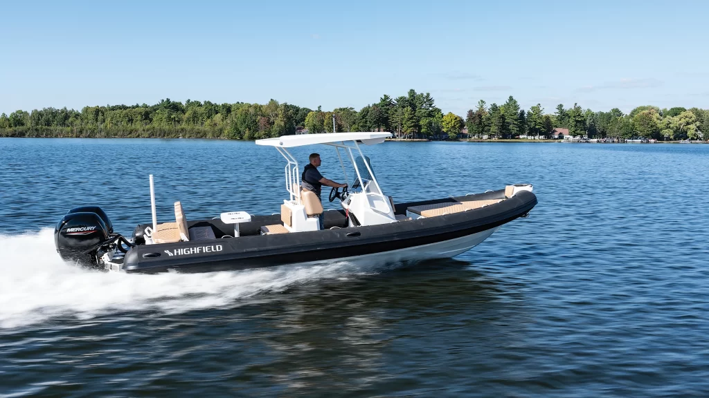
HIGHFIELD, A CRUISERS NET SPONSOR, is the leading builder of aluminum-hulled RIBs. Performance and strength are the key features of every HIGHFIELD RIB. Their advanced hull designs and Italian-influenced interior styling, keep alive the reputation of a dry-riding, seaworthy and stable craft that can handle rough conditions, as well as please the discerning eye.
Highfield
Available with up to twin 150-hp outboard power for breathtaking performance, the stylish Highfield Sport 800 (26′ 7″ LOA, 9′ 6″ beam) is equally suited to serving as a primary boat and a tender to a large luxury yacht. Highfield Boats’ rugged aluminum hull with a 26-degree deadrise provides a safe and stable ride in rough water. The Sport 800 can hold up to 15 passengers, and its multiple seating configurations offer comfort and space for the entire family. The aft cockpit has plenty of space and features a large removable table and handy refrigerator under the aft-facing seat, enough for six to dine comfortably. The rear seat folds over to form an aft sunpad, complementing the large sundeck in the bow. A standard hardtop provides both shade and sleek styling. highfieldnorthamerica.com
Are you wondering which tools of the trade are essential to have aboard your cruising boat? Ask Captain Chris what tools of the trade will be helpful….and why. Read more here
Cruising 101 FUNdamentals– This comprehensive seminar will open your eyes to the life of a cruiser and all the essentials you and your crew need to master before you leave the dock. Our 2-day seminars cover Crew and Vessel Communication, Safety, Trip Planning, Navigation, Anchoring, Provisioning, Knots … (read more and discover dates……)
Introduction to Boat Systems– Captain Chris will take the mystery out of maintenance in our Introduction to Boat Systems Seminar. If fuel filters, impellers & bilge pumps aren’t in your everyday comfort zone then it’s time to learn how to DIY.Click here to book a seat in this essential class of what to know before you go! or ASK CAPTAIN CHRIS 772-205-1859
Yes, we offer FREE videos on YouTube. As we cruise around the waterways and boatyards we see interesting things to video, narrate and post on YouTube so check out this short article on how to see thousands (yup, thousands) of these little gems….click here for FREE!


Be the first to comment!