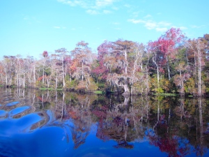
 Sanctuary and crew made our first visit to Conway, SC, on the Upper Waccamaw River, on October 29 and 30, 2013. On the advice of the dockmaster at Osprey Marina, we departed the ICW at Enterprise Landing, at daymark G’1.’ The channel in that area is narrow, and shoals to 7-1/2 feet for a short distance. Once past that area, the river widens and become a magnificent cypress swamp meandering stream. Navigation planning was only slightly more complicated than usual. `Standard’ NOAA charts do not cover the upper Waccamaw. The rule is, as always when upbound, `red, right, returning.’ The river is adequately marked with clearly visible daymarks. Navigation is straight forward. We stayed to the middle of the river on longer, straighter stretches, and favored the outside radius of turns and switchbacks. From the ICW at Enterprise Landing to Conway, a cruise of approximately 16 StM, there are three shoal areas: first, just above G’1,’ second, in the vicinity of R’12,’ and third, in the vicinity of R’16.’ We never saw less than 7-1/2 feet in any of these areas. There is a tidal ebb and flood, but these currents are insignificant for cruising boats.
 We stayed at the Conway City Marina. The marina `basin’ is on the west shore of the river. Upbound, the marina entrance is on an eastward curving bend in the river. The tidal range is about 18 inches. Reports published elsewhere of shoaling across the marina entrance are correct. Local guidance is to favor the green center-quarter of the marina entrance when entering and leaving the enclosed basin embayment. We were in the red-center quarter upon arrival, and even though we arrived virtually at high tide, we plowed through soft mud in the immediate area (50 feet) of the basin entrance. The second day of our visit, we chose high tide to relocate to another dock. By favoring the green center-quarter at the entrance bar, we observed that the shoaling carries to the green side, but we cleared it in about 5-1/2 feet of water. There is rip-rap on both the green and red outside-quarters of the entrance, so caution and slow approach speed is advised.
 The Conway City Marina is a residential facility, not primarily a transient destination. As first-timers to the area, we had excellent telephone support from the attendant, and we were certainly made welcome. There is no docking assistance provided. The marina offers three docking locations. One is a floating face dock inside the marina entrance channel. There is a small resident river tour boat on the north end of that dock, and there is also room on that dock for 2, 40′ cruising boats. It’s actually a 1/4-mile walk to the office from this dock. Outside the marina, 1/4-mile upstream of the entrance channel on the west shore of the Waccamaw, there are two 40′ floating docks immediately below the SC Rt. 905 road bridge. These docks are part of an extensive and beautiful River Walk system. It’s a 1/2-mile walk to the marina office from these docks. All of the docks have 30A and 50A power. None have potable water available. The docks themselves are aging, and in a generally dilapidated state of repair. Cleats on the in-river docks are loose and somewhat small for cruising boats. That said, the in-river docks do have two obvious advantages: first, approach depths are better, and second, the walk to the town is much shorter and easier. It is a very long walk to anywhere from the dock located in the marina entrance channel.
The City of Conway is the Horry County Seat (pronounced `Oar-ie;’ the `H’ is silent). There is A LOT of government here in Conway; a lot, including a large jail complex and the county courthouse. Discount coupons (`Discover Conway Downtown Shopping Card’) for visitors are available at the Visitor’s Center, 903 3rd Ave; (843) 248-1700. Get several cards, because you give up the coupon when/as you use them. History and architecture buffs will enjoy the city. There is a 2-1/2 mile riverwalk and park complex for walkers/joggers. There is a walking Heritage Trail of beautiful 19th century homes and the historic downtown. The locals are friendly. There are several good restaurant choices, and several nice, unique shoppes. Grocery shopping and the post office are not within what I consider to be walkable distance. Bikes would be an asset here.
Northern portion of Upper Waccamaw at Conway, SC
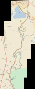
When Sanctuary and crew made this side trip to Conway, in October, 2013, the daymarks in the river were in good condition. In December, 2013, the USCG announced plans to permanently discontinue the lateral daymarks on the upper Waccamaw River. There are, however, some large tributaries and embayments that intersect the river; some are large enough to be confusing to first time cruisers in the area. Since there are no NOAA charts of the upper Waccamaw that cover the River, I superimposed Sanctuary’sGPS track on a road map of the area. I hope this will be useful in portraying the through-route of the river to Conway.

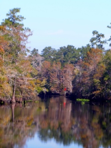
Southern Portion of Upper Waccamaw at Enterprise Landing, StM 375.
Clicking on these picture graphics will display them in a full-screen view. Further clicking will magnify them and allow scrolling. They are of high enough resolution that detail should be easily visible.
Despite some facility limitations and walking-distance challenges, this river trip is exquisite. It is unique, beautiful and well worth the effort.


Be the first to comment!