Capitol Access, Jerry Paul, Esq. Lobbyists at Florida’s State Capitol; News Release
Today marks Day 1 of the annual 60-Day Legislative Session. Although the House and Senate Committees have been meeting fairly continuously since December, the actual session, including consideration of bills on the full chamber floors, begins today. The Senate convenes at 9:30 a.m. and the House convenes at 10 a.m.
The opening day will largely be consumed with ceremonial events. Thereafter the pace will pick up quickly. This should be an interesting session. There are many newly-elected legislators following the recent elections and the conclusion of term limits for many past members. Of course many officials are already looking to their next election so some policy positions tend to be colored by that. (Remember, all of Florida’s Cabinet members – Governor, Attorney General, Commissioner of Agriculture, Chief Financial Officer – are up for election in just 20 months). But, there are also many serious matters on which the chambers will ultimately come together to resolve, not the least of which is the State Budget which will exceed $82 Billion. Although the State is expected to have a small surplus, the funds are largely already obligated so it is expected that it will ultimately be a tight budget year, particularly in the context of pending requests filed by members totaling more than $100 Million.
Today also marks the deadline for filing bills. The House and Senate bills on anchoring have both been officially filed. They are essentially identical and still reflect the provisions that we previously circulated. These bills will now move through the committee process including 3 committee hearings in the House and 3 committee hearings in the Senate. Then the bills will be heard on each of the full chamber floors and, if passed, would then go to the desk of the Governor for his consideration. The lead on these bills is Representative Holly Raschein (RFlorida Keys) who has invited me to attend a Stakeholder Meeting on Thursday during which all represented interests will sit together and go through provisions of the bill(s) to discuss any opposition. I will also be meeting with Senator Lauren Book who is the Senate Sponsor. We will provide a debrief to you thereafter.
The Cape Coral Cruise Club is a group of dedicated cruisers who always provide unique reports from the marinas they visit. Pink Shell Beach Resort and Marina, A SALTY SOUTHEAST CRUISERS’ NET SPONSOR!, overlooks the westerly banks of the Mantanzas Pass channel, west of marker #13. Pink Shell Resort and Marina is one CCCC’s favorite destinations, see March 2016 report.
PINK SHELL CRUISE FEBRUARY 21– 24, 2017 By Captain John Queen, Past Commodore, Cape Coral Cruise Club
The Cape Coral Cruise Club has monthly cruises to a variety of destinations in SW Florida. For the month of February 2017, that destination was the popular Pink Shell Resort and Marina on Fort Myers Beach. There was a good turnout with 17 club boats that made the trip ranging in size from 30 to 50 feet. Most of the boats arrived Tuesday, February 21st with fairly decent weather on their bow. Many boats waited until slack tide before arriving, as past experience knows, it is tricky trying to dock at Pink Shell in strong tidal currents. Since my wife Pati and I were the cruise leaders for this event, we were one of the first boats to arrive. We slid “Semper Paratus” into slip 20 around 10:30 AM just as inbound current was subsiding. Dockmaster Dave and his sidekick Craig did an excellent job in getting us and all other boats safely into assigned slips.
Tuesday afternoon was a time for relaxing and catching up with nautical conversation with other club members. At 4:30 PM, the members crowded the marina upper deck for our traditional Docktail hour with chips, pretzels and the like. As in the past, the marina has provided our club with a conference room at the resort, and this outing was no exception. At 6:00 PM club members convened in the conference room carrying food for the scheduled 1st night potluck. It’s always amazing how much love and innovation goes into the preparation of food in this club – members never go back to their boats hungry.
After dinner, club members anxiously waited for me to describe the fun and games portion of the evening. I had told them previously that we were going to play “The Awful Waffle Game” – with absolutely no other information provided.
As club members watched, 25 frozen waffles were stacked on an empty table in the center of the room. I asked for everyone to divide into teams of four. The object of the game “is easy”. “All you need to do is take the waffles and spread them out into 5 rows of 5 each, making sure that all waffle lines are perfectly aligned both horizontally and vertically”. I demonstrated with my hands how to do it. “After that, all you need to do is pick them up and dump them in this trash can across the room”. Again, I demonstrated how easy it was.
Each group was told it would be timed and the fastest team would win. Just before the first team started, I said, WAIT… there’s a catch! ELBOWS…ONLY!” (There is always a catch with my crazy made up games). Let the fun begin! It was a wild and funny sight watching these seasoned boaters trying to move and twist waffles with their elbows. Each team worked feverishly to beat the time of the previous team. When it was over, the winning team prevailed with a record time of 1 minute and 53 seconds. Prizes were awarded to the winning team and everyone had a good time. Thank goodness there was a vacuum cleaner in the room as scraps of waffles were everywhere!
The next morning, we prepared breakfast on our boat for 38 people consisting of scrambled eggs, sausage, bagels, croissants, and juice and carted everything up to the conference room for everyone to enjoy. Unfortunately, it started raining early Wednesday, and the trip from the marina to the conference room was not the best experience. But we got everything set up, and most boaters hiked up to the room to enjoy the breakfast.
After breakfast, our next fun game began. I explained to everyone that we would be doing a scavenger hunt. There were 10 questions or riddles to solve and the winner would be based on accuracy and speed. With that, I handed out envelopes to each boating couple and told them good luck.
As they opened the envelopes, they seemed unsure what to make of it. Each sheet of paper had what seemed to be a random spattering of letters running across it for several lines. It made absolutely no sense. (Of course it made no sense! I like to make people think!) I gave them one clue: “You need to work together to solve this!” Soon people started comparing their sheets of paper with other teams and realized not all sheets were the same. Finally, some of them realized that if they held the four variations the sheet together up to a strong light, it would reveal the message” THIS SCAVENGER HUNT SHOULD GIVE YOU A THRILL, YOUR LIST OF QUESTIONS ARE UNDER THE GRILL”. And with that, off they went.
Pati and I continued cleaning up the room after breakfast and retreated to the boat. I knew it would be a while before I saw anyone turn in their completed scavenger hunt questions. Some teams decided to wait for the rain to subside, while I saw other teams out there with their umbrellas and a wet sheet of paper trying to solve the riddles. As the day went on, the answer sheets started to trickle in. There were 8 teams that braved the weather and handed sheets in. I told everyone the results and winners would be announced at dinner that night. The rest of the day was spent by club members at the pool, walking the beach, shopping at Times Square, or simply ‘chillaxing’ on their boat.
At 6:00 PM everyone met at Matanzas Inn Restaurant for our group dinner. We usually have a group dinner on our cruises where other club members join us by land yacht. This outing was no exception as we had a total of 43 club members at the restaurant. The results of the scavenger hunt were revealed and prizes were awarded to the 1st, 2nd and 3rd place team. Everyone had a great dining experience at the Matanzas Inn and left will full stomachs. Since we had a number of people arrive by car, they were able to shuttle the boaters back to the marina and save them the 20 minute walk.
Thursday morning, we prepared another breakfast for all the boaters. Fortunately, there was no rain and we were able to set everything up rather quickly. After breakfast, some of the ladies stayed in the conference room to play cards, while others took walks, went back to their boats or simply enjoyed the Pink Shell Resort amenities. The weather was great most of the day.
Thursday night, club members headed off in different directions for dinner. On our club cruises, we usually designate Thursday night as ‘on your own’. Most of the boaters ended up at a handful of different restaurants on Ft Myers Beach.
Friday morning came too soon, and everyone prepared their boats for the journey home. Some boaters left early in the morning while others were in no hurry to get underway. The Pink Shell cruise was another great boating experience for members of the Cape Coral Cruise Club.
The Cape Coral Cruise Club is open to new members who own a boat with overnight accommodations and reside in the Cape Coral / Ft. Myers area. For membership information please contact Phil Kryger at 239-541-0236. Read additional Club information on its website, www.c-c-c-c.org Like us on Facebook.
Team Member Winston Fowler will be speaking to the Bradenton Yacht Club on the many useful features of Salty Southeast Cruisers’ Net’s free website and free mobile app. The dinner is open only to BYC members, but remember: SSECN is free, has no membership, no dues and no password – simply open and navigate.
If you are making this trip or a portion of the run, please contact Tyler.
Planning Abaco trip from SW Florida (Punta Gorda) via Okeechobee leaving April 7, 8, or 9. 17+ knot power boat. Would like crossing buddy boat. swansontyler7@gmail.com Tyler Swanson
Tyler, What are your destinations once you reach the Abacos? Your 17 knots will be reduced to 13 or 14 at the apex of the gulf stream. Harold Aboard “IDGARA” Key Largo
Jewfish Key Anchorage will be found on the deep water southwest of the long private island southwest of flashing daybeacon #41, known as Jewfish Key. Our thanks to Skipper John for this review and advice.
Very nice anchorage – we spent 3 days here late February 2017. When we were here the water due SW of Jewfish Key was not as deep as depicted on the charts so head WNW immediately after clearing the southern tip of Jewfish. We enjoyed good Italian food at the Bayou Tavern, a short walk from the beach in the anchorage. John
Patricio Island Anchorage lies off the southern banks of Patricio Island, which borders the non-GICW Pine Island Sound channel, east of Useppa Island and north-northeast of the Waterway’s flashing daybeacon #52. Our thanks to Skipper John for this report.
We enjoyed the solitude of this anchorage for 3 nights. Winds were from the SE at 15-20 mph so we hooked up closer to the Broken Islands. It’s nice to be well off the inter-coastal – we had the place completely to ourselves. If you are into bird watching, you will have your share off the Broken Islands. We were also greeted by a Manatee our first night just after setting the hook. John
York Island Anchorage is located off the southern shores of York Island, well northwest of the ICW’s flashing daybeacon #13. Our thanks to Skipper John for this report.
We anchored close to York but actually right in front of St James since we wanted a shorter dinghy ride to town. Winds were as predicted from the NW at 10 to 15 MPH so it was a pleasant evening. We got a bit of boat wake bouncing us around in the day time but nice calm evenings. I think there would be less boat traffic in front of York but then you have a longer dinghy ride if you want to go into town. St James is a pretty casual town, a few bars, a minimal general store, nice gift shop, and a pottery shop. Gunk holing the canals of St James in the dinghy was pretty cool. John
Anchoring Florida Legislative Update 2/24/2017 Presentation of the Proposed Committee Bill (“PCB NRPL 17-01 – Vessels”) was positive. The Chair of the committee and its members have been accessible to us and responsive to our positions. Our lobbyists, Capitol Access have been in constant contact with committee members prior to the drafting of the bill and continuing.
So far, the team effort lead by MTOA along with AGLCA, SSCA, DeFever and many others has worked well to help shape the initial draft of the Bill that has been filed in the House as a Committee Bill by the House Natural Resources & Public Lands Subcommittee The Bill itself is consistent with the input from our team, which collectively considered all provisions recommended by the FWC (Fish & Wildlife Conservation Commission). All positions of our cruisers groups are reflected in the bill as it is currently drafted. Good job to all and appreciate your thoughtful, timely response.
On Wednesday, the Committee meet to hear the bill publicly and vote on whether the Committee itself would move forward as its official sponsor. Our lobbyists, Capitol Access, attended and represented us including Jerry Paul, our lead lobbyist, who provided comments to the committee stating our general agreement with the provisions and thanking the committee for excluding provisions that would have created no-anchoring set-backs from residential property; excluding provisions that would carve out specific no-anchoring zones; and including provisions ensuring that anchoring regulations remain in the jurisdiction of the State rather than allowing local jurisdictions to create a confusing patchwork of anti-anchoring ordinances.
Mr. Paul also mentioned our intent to seek a reduction of the 300-foot buffer around mooring fields which is a provision in the current version of the bill. The committee voted unanimously to proceed forward with the bill. Next, it will receive referrals to multiple committees that will hold hearings and consider amendments that may be filed. Chair of the originating committee has agreed to meet with us and continue working with us. We will be vigilant in all committees to review and represent ourselves as to any amendments that may be adverse to our interests. There may be a need for cruisers to attend such hearings in Tallahassee.
Also, we are anxiously awaiting the filing of a bill on the Senate side. The process there will repeat that of the House as described above. The committee hearing process will continue until a final bill on the House and Senate reach their respective chamber floors for final votes which will occur sometime prior to the end of the official 60-day Legislative Session which begins on March 7.
We will continue to keep you updated. For now, you can be proud of the success you are having as a team that took the time to step up and speak out. However, we have future challenges ahead, and your presence at Florida’s Capitol may be requested for one (1) day. If you can attend you are requested to bring a burgee attached to a wooden rod aprox.3/8” Día X 24” Long. This will give committee members an additional visual demonstration of the boating community’s support for unnecessary new anchoring regulations. Mike Bodin MTOA Public Advocate mbmtoa@gmail.com
MTOA Florida Legislature Update 2/16/2017 Enclosed is the latest review from Capitol Access in Tallahassee representing the following Boating consortium: SSCA, Standing Watch, AGLCA, MTOA, CFFW. We are promoting safe and considerate use of anchorages, and opposed to unjustified regulations of Florida’s waterways. The Boating consortium has had great success with the initial bill that was filed last night. The provisions of the bill are consistent with essentially all components of the consortium’s position:
1. The STATE reserves all authority to adopt anchoring and mooring regulations (therefore avoiding a patchwork of differing regulations at the local level).
2. There are no anchoring setbacks measured from residential waterfront properties.
3. The setbacks from boat ramps, launch facilities and marinas is 150 feet.
4. The buffer around existing mooring fields is 300 feet (as-recommended by FWC
5. There are no additional anchoring limitation areas throughout the State This bill will be filed by the House Committee on Natural Resources and Public Lands, Chaired by Rep. Holly Raschein whose district covers the Florida Keys. The next step will be for the Committee to vote on whether the Committee itself will file this as a bill sponsored by the Committee (rather than a bill filed and sponsored by an individual member). Following that vote, the bill (called a PCB or Proposed Committee Bill) would then receive referrals to multiple committees and be heard in each one successively. Of course, Capitol Access would be in attendance at every step and provide their input.
Capitol Access will watch for any amendments that are filed. There may be a need for our boaters to appears and give testimony.
There is no Senate bill filed yet. Capitol Access is lead lobbyists.
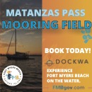
Fort Myers Beach, A SALTY SOUTHEAST CRUISERS’ NET SPONSOR, includes Matanzas Pass south of the western terminus of the Okeechobee Waterway and Matanzas Pass is home to SSECN SPONSOR, Pink Shell Resort and Marina. Comments are requested by March 15.
News Release Feb. 10, 2017 Coast Guard asks mariners help to designate anchorage area
TAMPA, Fla. — The Coast Guard is asking mariners to participate this month in a Waterway Analysis and Management System study of the mooring area adjacent to Fort Myers Beach.
This outreach is designed to gather information on the potential designation of the Matanzas Harbor Mooring Field as a Special Anchorage Area and establish a Special Local Regulation for the anchorage.
A Special Anchorage Area is a designated and charted area with federal oversight where boats may not be required to carry or exhibit anchorage lights while at anchor.
“We want to get the word out to waterway users in the area and seek their comments or concerns,” said Chief Warrant Officer Darren Pauly, the aids to navigation officer at Sector St. Petersburg. “The WAMS survey provides a great way for the public to provide their vital input.”
WAMS studies are conducted year-round on waterways all around the country and focus on managed mooring fields, anchorages, aids to navigation systems, waterborne commerce, marine casualty information, port/harbor resources, and future development projects.
Interested participants can also contact, Commander Sector St. Petersburg Attn: BOSN Darren Pauly 600 8th Ave, S.E. St. Petersburg, FL 33701 (813) 228-2191, ext. 8184. E-mail to darren.a.pauly@uscg.mil.
U.S. Coast Guard 7th District PA Detachment Tampa Bay Contact: Coast Guard PA Detachment Tampa Bay Office: (727) 535-1437 ext. 2143 After Hours: (305) 965-4672
The Cape Coral Cruise Club is a group of dedicated cruisers who always provide unique reports from the marinas they visit. Legacy Harbour Marina, A SALTY SOUTHEAST CRUISERS’ NET SPONSOR, is located on the Caloosahatchee River/Okeechobee Waterway, in the heart of downtown Fort Myers, Florida. Multiple dining and shopping opportunities are found within easy walking distance of this absolutely first-rate marina!
Cruise Club returns to Legacy Harbour
by Michael Stewart
It was bluebird weather for the Cape Coral Cruise Club members taking part in the 2017 Legacy Harbour Cruise. All nine boats made it in, one boat being late while waiting for refurbished props to be reinstalled. First time Club cruisers, Bobby and Joyce Miller arrived is style with their prospective member pennant proudly displayed. Welcome to the Club!
First night post docktail food was provided by the cruisers – just too much and too sumptuous to list. If anyone goes hungry on one of our cruises, they only have themselves to blame.
Wednesday morning started with a breakfast of toasted breakfast bread and butter, fresh fruit, quiche mini-muffins, orange juice and tomato juice. Attendees brought their own coffee. Following a short break after
Legacy Harbour’s Chickee Hut
eating, everyone reassembled at the Legacy Harbour chickee hut to begin a scavenger hunt. There were three outstanding prizes to be awarded, consequently, competition among the CCCC members can get quite intense…! Fierce competition ensued as the boaters returned to their respective vessels in search of the listed items. Would you allow two mismatched oven mitts as “work gloves”? How about a jar of “teak oil” that looked suspiciously like vegetable oil? And did the same miniature sewing kit get passed around with the teensy baby pin in it? Anyway, a lot of fun was had and Moonlighter, Hardee II, and Happy Ours triumphed as the successful winners. The prizes were wrapped so that no-one could tell what was inside (contestants were not allowed to touch the packages). First place got to pick, then second, then third. Then everyone hauled their collections back to their boat and split to various downtown Ft. Myers restaurants for lunch.
A non-cruise related Club function occupied many of the cruisers for Wednesday dinner, however, the remaining cruisers held their own docktails and happy hour before heading on the town for dinner.
Thursday morning breakfast, included a breakfast quiche (imagine a casserole of eggs, diced potatoes, spinach, diced ham and spices), fresh fruit, breakfast bread and juices. It was a game day for many attendees, lunch on your own, followed by dinner at Pinchers Crab Shack. The boaters were joined by some 15 club members who arrived at Legacy by land yacht that night to join in with us.
Prior to departure on Friday for their home ports, many boaters used the pump out facilities in preparation for the next month cruise to Pink Shell Resort. It is a LOT of fun cruising and being with fun people!
The Cape Coral Cruise Club is open to new members who own a boat with overnight accommodations and reside in the Cape Coral / Ft. Myers area. For membership information please contact Phil Kryger at 239-541-0236. Read additional Club information on its website, www.c-c-c-c.org Like us on Facebook.
Siesta Key is immediately south of Big Sarasota Pass. The Gulf Waterway runs parallel to the east side of Siesta Key. The beached sailing vessel is obviously on the Gulf side of the Key and says something about total reliance on GPS for navigation. Our thanks to YourObserver.com for this photo and report.
Sailboat runs aground on Siesta Key Beach The owner told several bystanders his navigation system crashed on the way to St. Petersburg. by: Alex Mahadevan News Innovation Editor A roughly 30-foot sailboat named Anthem ran aground on Siesta Key Beach Sunday, creating a photo opportunity for island visitors and residents all week.
The owner of the vessel, which is based out of St. Petersburg, told bystanders he was traveling home in the Gulf of Mexico when his navigation system crashed, sending the sailboat over a sandbar and onto the public beach. Sea Tow, a boat towing service, is waiting until a higher tide this week to haul the ship back into the gulf.
“It’s not very easy,” said Sea Tow Bradenton office manager Amanda Newell. “They need a towboat by sea and people on the sand to pull that sucker out of there.”
Share:
Comments from Cruisers (1)
pat kennedy- February 3, 2017 - 8:50 pm
Sea tow pulled off the beach this afternoon 2/3/13
Chino Island Anchorage is north of the Gulf Waterway’s intersection with the Okeechobee Waterway, off the southwestern shores of Chino Island, north/northeast of unlighted daybeacon #24. Our thanks to John for this report.
Great anchorage for us the evening of January 30, 2017. Winds were light and variable. We had the place to ourselves probably because it got down to 45 degrees F. John
Florida’s Anchoring Program Update 1/30/17 MTOA Boaters’ rights to anchor in public waterways are under attack again in Florida. SSCA, MTOA, and AGLCA, are raising money to fund a professional lobbyist to defend our rights. The lobbyist team Capitol Access, Tallahassee, is now representing boaters from unjustified regulations. Help us to stop the attack on Florida’s anchorage areas. Please donate TODAY:
www.mtoa.net “BOATERS’ RIGHTS FUND” {Note: Click on Chart below Boaters’ Rights Fund, then ignore Log In to Contribute and go directly to name/address form.}
Many wealthy Florida waterside residents, condominium units and cities complained to their local governments about anchoring boats spoiling their water views. Federal government owns the land under waterways and relinquished semi-control to Florida state. This anti-anchoring consortium contacted their state representatives to change the law to prohibit anchoring in front of their waterside property Florida enacted a study called Anchoring and Mooring Pilot Program in 2009. The study is to be completed July 1, 2017. Final recommendations to be submitted by January 1, 2018. The multi-million dollar 244-page report is available for review. “Anchoring and Mooring Pilot Program Final Report of Findings and Recommendations 12/21/2016” in Adobe PDF. During last year’s legislative season the report was accepted as submitted. 2017 is the final year. Florida legislature has stated they will accept the state recommendations for state law. The report has several anti-anchoring provisions that must be changed to better represent the needs of the boating community. One glaring item of concern; If enacted, county governments can easily contact the state for an exemption to control and regulate local anchoring without any input from the boating community. The unintended consequence of the legislation would be the precedent it would set for other states along the eastern seaboard to follow banning anchoring. A large “AHOY MATE” call is now being made to fellow boaters. As a boating community, we can be complacent, stand back and complain when our previously used anchoring areas are no longer available or put on some heavy weather gear and ride the storm out while still keeping the heading. This will ensure future anchorage availability for us and our children. How is this accomplished? As any boater knows you must have the right gear. 1) We need a knowledgeable professional lobbyist. 2) Money is required for this lobbyist: $35k, 3) How do we get the funds? The boating community unites and individual boaters to donate as they can. Marine Trawler Owners Association (MTOA) has engaged the services of Capitol Access, an outstanding lobbying firm with offices in Tallahassee to represent all boaters interest from unjustified regulation upon the waterways., Today combined funds from members of American Great Loop Cruising Association (AGLCA), and Seven Seas Cruising Association (SSCA) are assisting with contributions from their membership. Additional funds are required to continue a pro- anchoring strategy to roll back unjustified regulation of anti-anchoring language in the proposed bill. Your support is requested. Marine Trawlers Owners Association has set up the following site for your donations from the boating community at large: Go to: www.mtoa.net highlight tab “FL Anchoring Rights Fund” We need your financial support. The following is a time progression review demonstrating the need for a professional lobbyists and active boater participation to win the pro-anchoring debate. 2017 2016 over whelming defeat for pro-anchoring advocates required a change in tactics for boaters right to anchor. MTOA closely reviewed the situation and with board consensus agreed a professional Lobbyists was required to prevent 2016 outcome for the 2107 legislative season. We have now finalized the engagement and compliance registrations for our lobbyist in the Capitol (Jerry Paul of Capitol Access). As you may know, Jerry is a member of MTOA, SSCA, AGLCA and DeFever Cruisers. He is an active cruiser, a former marine engineer, merchant mariner, attorney and former elected member of the Florida Legislature. He lead our successful efforts in Tallahassee 2 years ago under the lead of SSCA. This year MTOA is the lead client and coordinator working closely with Jerry. Special thanks to SSCA and AGLCA for joining the team and for providing additional funding support for the effort. Thank you also for the contributions by members of our organizations and others such as the DeFever Cruisers. We are up and running. Jerry is in communication with key legislators who will be involved in this process throughout Florida’s Annual 60-day Legislative Session which begins on March 7. There are 3 remaining “Committee Weeks” that will occur prior to March 7 during which legislators will be filing bills and even holding hearings in preparation for the regular session. Through the counsel of our lobbyist, we will apply the approach that worked well when we were last organized a couple of sessions ago. For example, he will keep us updated regularly as he collects information. Through him we will coordinate effective messaging (some wholesale and some retail) that leverages our vast number of cruisers and the merits of our position. But, it is important that we maintain control of the message. It needs to be tailored to the specific issues that are critical to the moment as legislation makes its way through multiple committees comprised of different elected members (and staff), each with unique perspectives. Our messaging must be respectful and professional. Finally, it must be timed precisely and targeted surgically in varying ways (email, phone, and even personal appearances in Committees). This is a running process so timing is important. Mike Bodin, MTOA, Public Advocate will be coordinating these activities. So far, it appears as though there will be a bill filed that implements some of the recommendations of the Report by the FWC (Florida Fish & Wildlife Commission) which was prepared to summarize the results of the Anchoring and Mooring Pilot Project that expires this year. This is the report that was recently heard by the Senate Environment Committee (the committee that originated the language a couple years ago, that including certain anchoring bans). A draft of the bill is not yet available. We are in communication with the key likely sponsors and we’re already messaging our opposition to such bans. So far, it appears we have some key members who associate with our view. We are hopeful that the initial draft(s) will not include the adverse provisions. If it does, we will work to get it removed. If it does not, we must be vigilant until the end of the Session to ensure that the adverse language does not get amended into it. We will report on these developments and follow up with effective calls-to-action by our members and all who share our desire to preserve Florida’s rich maritime history of freedom to safely anchor throughout the public’s coastal waters of the State 2016 REVIEW Yeas, represent the Anti- Anchoring votes by the committees and legislature: 1/26/16 House Committee Vote yeas 12 Nays 0 2/25/16 House Committee Vote yeas 15 Nays 1 Note: Extreme spread 3/04/16 House Vote yeas 105 Nays 12 3/0716 Senate Vote yeas 36 Nays 2 3/09/16 Signed by officers and presented to Governor HJ 980 3/24/16 Approved and signed by Florida’s Governor Rick Scott (chapter 2016-96) 7/01/16 Effective Date for state law banning anchoring by county designation. The state law banned overnight anchoring within areas of Broward and Miami-Dade counties. Once it was seen there was no opposition from pro- anchoring groups, anti-anchoring legislation emerged and gathered enough momentum to easily pass. Do not underestimate the extent to which that momentum is perceived to still exist in Tallahassee. It was quite evident at the Senate Environment Committee (the Committee that originated the bill we defeated 2 years ago). Notice that this Committee chose to place the topic on its agenda early in the process. The cruising/anchoring interests have been unrepresented for a while and that has been noticed. Note: The boating community was complacent. No Lobbyists, No boating community involvement. Capitol Access was not retained. 2015 REVIEW No set back or anchoring restrictions—Capitol Access, Active Lobbyists, Active boating community 2014-2012 REVIEW No set back or anchoring restrictions—Capitol Access, Active Lobbyists, Active boating community It can plainly be observed if boaters are again complacent in 2017, the 2016 results can be expected. We salute such groups as American Great Loop Cruising Association, Seven Seas Cruising Association, Marine Trawler Owners Association, and DeFever Cruisers for their active and financial support. These great organizations have started the process. Now your financial support is needed to continue. Donation site www.mtoa.net highlight tab
The Concerned Cruisers’ Committee (CCC) of Seven Seas Cruising Association (SSCA) has, for many years, supported the rights of cruisers to navigate, anchor and enjoy the “Seven Seas” both in the U.S. and abroad. We have had recent success in Annapolis and in Georgia, and we are engaged in South Carolina, Washington and California.
CLICK HERE TO DONATENOTE: Ignore the “Log In to Donate” and go directly to name/address form.
1/23 A good news update from MTOA Public Advocate, Mike Bodin:
But as of now (1/23/2017), SSCA, AGLCA and MTOA have raised over half of the funds from their membership for the Lobbyists. Capital Assets has agreed to represent the boating community and their office is in Tallahassee.
And this from Mike Bodin:
Mates, As you know Florida’s legislative session has started. The Environmental Preservation and Conservation committee heard the first presentation by The Fish and Wildlife Conversation commission (FWC) on the Anchoring and Mooring Pilot Program. [See /161714] Anti-anchoring representatives were present and offered presentations.
The window is closing for us to be effective with ongoing legislation. Capitol Access team did a great job representing our anchoring concerns in 2014,and 15. Without professional representation I fear legislation will be made and passed into law prohibiting anchoring by county designation with state approval. This Florida law can be the basis of others to follow along the ICW corridor. Like cancer, a small start than it spreads and very difficult to stop.
Time is against us to raise monies for a professions lobbyist. MTOA donation survey results are very promising, AGLCA is now surveying their members and results will be available shortly.
SSCA CCC has lead the boating community in the past. Anti-Anchoring is a pain in every boater’s thoughts. Future state laws to prevent anchoring along the ICW surely can be compared to the spread of cancer. We must unite and knock it out before it gains traction.
Enclosed is a boaters rights donation form to your GoFunfMe site. Due to the tremendous time limitation now in place we request SSCA blast email the form to your membership. Within a couple of days, we will have a good idea if a lobbyist can be added to our anti-anchoring efforts.
Thank you for consideration and hopefully participation.
And from America’s Great Loop Cruisers’ Association:
Boater’s Rights Interest Survey Florida’s 1,000-mile intracoastal waterway has often been called the boaters’ highway. Wealthy waterside residents in conjunction with several counties want to enact anti-anchoring laws. Last year Florida’s governor signed into law temporary nighttime anti-anchoring restrictions in several counties. Boaters must unite to stop the spread of anti-anchoring legislation.
“Yes, Florida residents should care. Snowbirds should care. Loopers and long distance cruisers should care. Boaters who never leave their home waters in Rhode Island or California or Maryland should care. You should care, Phil. Suppose you can no longer anchor in Mattawoman Creek or down at Tim’s Rivershore?”
I agree with your points Dave, 100%. (Actually a better analogy might have been the creeks around Annapolis–hardly anyone lives at Mattawoman or Tims.) But the reality of the anchoring problem is that we need money and we need volunteers and you just ain’t getting them from Tennessee (no offense to those in Tenn.)
That everyone should care is a valid but weak argument. Those of us who made a donation whether large or small, did so partially because it was made easy, with a few mouse clicks and a credit card. Throwing stuff at the wall hoping some of it will stick is not an effective call-to-arms.
If I was a retiree boater living in FL I would more inclined to volunteer to drive to Miami or Tallahassee and foot the hotels bills at my expense. I’m neither of those and personally, we have our hands full up here in the Northern VA. That’s why we spread the loop out over 2 years instead of doing it all at once. Plus, with a take-no-prisoners style of doing things, anything I would do might be counter-productive! Some probably look at this as “someone else’s problem” but we certainly don’t.
Will it “spread to other east coast states”? Not in our lifetimes. Florida is a unique critical mass of anchorages, waterfront homeowners and boaters.. The few causing problems are the problem. Google “anchoring laws” or “anchoring restrictions” and Florida dominates. Number two California isn’t even close.
This debate has already attracted a healthy attention to the problem. Hey, Jim Healy has signed on. We owe him big time just for his informative contributions to the forum. Him volunteering for the anchoring work is above and beyond. Jim, we are buying you and Peg dinner if we ever meet up. Others should do the same. And thanks to the others who have volunteered!
There are over 4,400 AGLCA members. If every member contributed only $25 (some did more) you would have well over $100,000. Just like crowdfunding (yes, you can laugh). That’s a healthy start instead of the 20K collected so far which is only a 20% participation rate, roughly. Just a few mouse clicks and a credit card. But if you want volunteers, make it easier like the contributions and focus on Florida. That’s where the problem is. So is the solution.
The various boating groups have come together just in time to hire a capable lobbyist (Jerry Paul) who happens to be a boater who recently moved his boat north by Tallahassee. Yesterday the Trawlers & Trawlering list owner endorsed the effort and asked members to support it. While there have been many people involved, Mike Bodin of MTOA should be commended for staying involved, taking the lead and keeping the boating community informed. Jim Quince
Something to keep an eye on….. It has been reported that the chair of the Senate committee that received jurisdiction to hear the FWC Anchoring Report (and the committee most likely to originate anti-anchoring legislation) is chaired by a newly elected Senator who happens to be the daughter of the lead lobbyist who has represented the anti-anchoring interests for the last several sessions. We do not know whether she has preconceived opinions or biases on our topics. She did not display a bias in this first hearing. We must give her the benefit of the doubt and commit ourselves to working with her in a professional manner throughout this process. Jim Quince
America’s Great Loop Cruisers’ Association has joined other boating organizations is requesting donations toward lobbying for boaters’ rights in Florida. See /162138 for more information.
As a result of the recent survey on anti-boating legislation, AGLCA is beginning to accept donations along with other boating organizations to hire a lobbyist to represent our interests at the Florida Legislature. This link can be used to make your contribution to the Boaters’ Rights Lobbyist Fund. When making your contribution, consider how much money you save in slip fees by having the ability to anchor. If you would like more information on this issue, you can view my recent forum posting.
Thank you for joining AGLCA in this lobbying effort. I will keep you posted as we move forward with this issue. Kim Kimberly Russo Director America’s Great Loop Cruisers’ Association krusso@greatloop.org
1/26/2017 Update:
The three associations leading this charge (AGLCA, MTOA, and SSCA) are doing well in the fund raising effort. To date, 161 AGLCA members have contributed. We’re so thankful for all of those contributions, but there are about 100 more of you who answered our survey last week expressing your intention to contribute. If you have not yet done so, please make your contribution by clicking here as soon as possible.
Although we are not yet at the $35,000 goal, we believe that number is attainable. In addition to contributing substantial time, effort, and administrative expenses, AGLCA and MTOA have agreed to help bridge the gap, if one exists after all contributions are in, to reach the needed amount. Since the amount needed is within reach, we have retained a lobbying firm (Capitol Access) in Tallahassee to represent our interests this legislative session. The goals have been defined as follows:
Prevent the passage of Florida legislation that would ban or curtail overnight anchoring on public waters in locations defined by proximity to upland private dwelling units including but not limited to other provisions that unduly restrict anchoring on public waters. Monitor and track all legislation that could adversely affect our members’ interests. Increase our presence among officials in Florida government to build an enduring image of strong influence for the boating and cruising community on matters related to the lifestyle of boaters and cruisers on Florida’s waterways. Our lobbyist/consultant has agreed to:
Monitor, track and report to the AGLCA all legislation and amendments filed or otherwise considered in Florida that could affect the interests of our members. Meet with key officials within Florida government to introduce AGLCA as a leader for the interests of cruisers and other boaters that it is now represented in Florida’s Capitol. Provide proactive lobbying and advocacy to actively support the legislative positions of AGLCA including but not limited to opposing Florida legislation that would ban or curtail overnight anchoring on public waters in locations defined by proximity to upland private dwelling units. This will include the organization of messaging and public appearances in the Capitol by members of the cruising community who support AGLCA’s positions. Report to AGLCA at least monthly the meetings and activities conducted on behalf of AGLCA. Jerry Paul, President of Capitol Access, is a trawler owner, lifelong cruiser, marine engineer, attorney, former elected member of the Florida Legislature and former Presidential-Appointed, U.S. Senate-Confirmed Official within the U.S. Department of Energy. He has extensive experience in the transportation field, maritime industry, boating, cruising, energy, government affairs and communications including a balance of experience in operations, regulatory, legislative, finance and restructuring work. Jerry is a graduate of Maine Maritime Academy and has held U.S.C.G. licenses as an engineer and captain. Jerry has also extended our coalition of boating associations a very generous discount for his services. Thank you, Jerry! Kim Russo Director America’s Great Loop Cruisers’ Association krusso@greatloop.org
MTOA is joining other boating organizations in requesting donations toward lobbying for boaters’ rights in Florida. See /162138 for more information on anti-anchoring regulations.
The marked channel from Tampa Bay into the Manatee River west of Sneads Island passes 1ft depths to the east, between markers #5 and #8, and can easily snare the careless captain, as the photo below attests. The grounded sailboat is off the point of Sneads Island.
Off point of Sneads Island
Share:
1 Facebook Likes, 1 Facebook Reactions
Comments from Cruisers (3)
Winston Fowler- January 20, 2017 - 10:09 am
The grounded vessel is a derelict vessel in about four feet of water just off McKay Point a good mile or so into the Manatee River near Snead Island Boat Yard. Stay in the channel and you have ample water. Some of the tightest spots will be at the very entry out in areas between Green 1 and Red 2. Winston Fowler
I am a 8foot draft vessel looking for dockage at Regatta point up the Manatee river. I saw the grounded sail boat off Sneed Island in your post. My question is can I make it past Marker 5 and 8 in the channel or is the shoaling extending into the channel. I would appreciate any local knowledge regarding my passage as I plan to call this home for a few months. Pintail
Living up the Manatee River, I have not seen the river entrance change much over the past years. If you follow the markers there is plenty of water for boats up to a 7 ft draft. Came up the river this morning and it look like the sail boat has been moved off the sand bar. You should have no problems visiting any of the three marines on the river.
This report comes from the BoatUS Government Affairs site and was sent to us by regular contributor and experienced cruiser, Greg Allard. Numerous comments on the controversial program have been posted on SSECN and these can be found by typing anchoring or mooring in our Homepage search window.


 nine boats made it in, one boat being late while waiting for refurbished props to be reinstalled. First time Club cruisers, Bobby and Joyce Miller arrived is style with their prospective member pennant proudly displayed. Welcome to the Club!


Be the first to comment!