Visit Logged
  • Select Region
    • All Regions
    • VA to NC Line
    • North Carolina
    • South Carolina
    • Georgia
    • Eastern Florida
    • Western Florida
    • Florida Keys
    • Okeechobee Waterway
    • Northern Gulf
    • Bahamas
    • New York
    • Ohio
    • Pennsylvania
    • Washington
    • Puerto Rico
    • Minnesota
    • Maryland
    • Tennessee
    Order by:
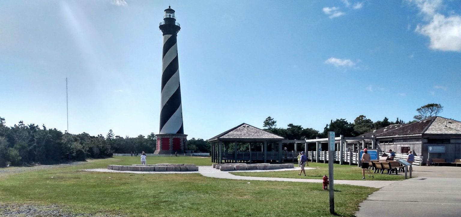
    • Hatteras Lighthouse Home to New Webcam, Cape Hatteras, NC


      With the launch of a new webcam, anyone with access to the internet can see the view from the top of Cape Hatteras Lighthouse.  The webcam can be viewed at www.obxforever.org/obx-national-park-webcams/www.outerbanks.org/webcams and www.surfline.com.


      Cape Hatteras National Seashore. Photo: Jennifer Allen


      Hatteras Lighthouse Home to New Webcam
      Coastal Online Review

      Be the first to comment!

    • St Augustine Morning Net now at 9:00AM on Channel 72

      For all the latest St. Augustine Cruising News, especially here in Race Week, tune into Morning Net on Channel 72. Our thanks to Michelle Bennett for this update. See Race Week.
       
      Hi Larry,
       
      Just a heads up the St Augustine Cruisers net has changed the time for morning net, it’s now at 9:00am on channel 72 every day through the end of May. We take a break June through October but have events all year long. More info at www.facebook.com/groups/CruisersNet.
       
      Thank you,
      Michelle Bennett

      Be the first to comment!

    • USCG: Sector Charleston Prepares for Upcoming Hurricane Season

      See also Hurricane and Severe Weather Preparation.


      SECTOR CHARLESTON

      UPCOMING 2021 ATLANTIC HURRICANE SEASON

      The Atlantic Hurricane Season will begin June 1, 2021 and will run through November 30, 2021. During this timeframe, the assigned port condition (PORTCON) will remain PORTCON IV and the port status will remain OPEN for all ports and waterways within the Sector Charleston Captain of the Port Zone. These waters are identified in 33 CFR 3.35-15 and lie between the intersection of the North Carolina – South Carolina boarder and the northern bank of the Savannah River.

      In the event of forecasted tropical storm force winds (sustained winds of 34 kts/39 mph or greater) from a tropical cyclone, the Sector Charleston Captain of the Port (COTP) will coordinate with the Heavy Weather Advisory Group (HWAG) to evaluate port preparation and changes in port condition.

      The HWAG consists of maritime transportation system professionals local to the Sector Charleston Captain of the Port Zones, providing input on local operations and coordination for overall port well-being in response to severe weather events.

      The COTP will announce changes to port conditions via a Marine Safety Information Bulletin (MSIB) and a Broadcast Notice to Mariners when forecasted tropical storm force winds (sustained winds of 34 kts/39 mph or greater) from a tropical cyclone threaten South Carolina. These port conditions are as follows:

      Forecasted Hours Prior to Tropical Storm  Force WindsPort ConditionMeasures in Effect
      1 DEC – 31 MAYVGeneral. Port status is OPEN.
      1 JUN – 30 NOVIVHurricane seasonal alert. Industry to review heavy weather plans. Port status is OPEN.
      72WHISKEYThe COTP will assess lay-up and mooring plans, meet with stakeholders, and conduct port assessments. Port status is OPEN.
      48X-RAYThe COTP will finalize review of lay-up and mooring plans, hold further meetings with stakeholders, and continue port assessments. Port Status is OPEN.
      24YANKEEThe COTP may restrict vessel movements, including stopping inbound vessel traffic, and cargo operations. Port status is OPEN with RESTRICTIONS.
      12ZULUThe COTP may restrict all vessel movements, including stopping inbound and outbound vessel traffic, and cargo operations. Port status is CLOSED.
      AFTER

      STORM PASSAGE

      OPEN or OPEN with RESTRICTIONSPrior to authorizing vessel movements and cargo operations, the COTP will conduct a risk analysis based on actual weather observed and port assessments, which may include verifications of aids to navigation, channel hazards, waterfront facility damage, and vessel accountability.

      Very Respectfully,

      LT Chad Ray

      USCG Sector Charleston

      Waterways Management Div., Chief

      (843) 323-7761


      All vessels, waterfront facilities, and marinas should review their heavy weather plans now. Please take into account that drawbridges may not open for vessel traffic when sustained wind speeds reach 25 mph or during land evacuations. Vessels or oceangoing barges greater than 500 gross tons that are unable to go to sea are required to submit heavy weather plans to the COTP. The request form can be obtained from Sector Charleston’s HOMEPORT internal site at https://homeport.uscg.mil/port-directory/charleston. All requests should be submitted to D07-PF-SECTORCHASN-WWM@uscg.mil. The COTP will carefully evaluate vessels requesting to remain in port. Submission alone of a Remain in Port Request does not grant approval from the COTP.


      Currently, and running to May 31, 2021, the threat of severe weather is decreased. PORTCON V with a port status of OPEN remains in effect. This, however, does not prevent the COTP from changing port conditions in the event of forecasted severe weather.

      For HWAG or waterway specific questions, please contact (843) 323-7761. For facility and foreign vessel specific questions, please contact (843) 740-3186. For domestic vessel specific questions, please contact (843) 754-2076. For Coast Guard related emergencies, please contact Sector Charleston Command Center at (843) 740-7050.


      This MSIB can be viewed at https://homeport.uscg.mil/port-directory/charleston.

      Attachments area
      Be the first to comment!

    • Still More on Florida’s Restrictive Anchoring Legislation

      Anchoring restrictions imposed by Florida’s legislators have been increasing for years with legislators pressured by wealthy landowners to remove all visiting vessels. See Restrictive Anchoring Legislation by Jim Healy . Our thanks to Fred Ruggiero for this report.
       
      My Name is Fred Ruggiero Jr. and I am a member of the Bradenton Yacht Club, Fl., FCYC, (Florida Council of Yacht Clubs).
       
      Florida’s proposed bill, HB 639, while containing valuable boating safety legislation, contains in 327.4108, restrictions/limitations on anchoring.

      While this issue is framed as a derelict vessel issue, as is often the case, the regulations, laws, and statutes needed for identifying and removing derelict and at-risk derelict vessels are in place. Florida’s FWC and Florida law enforcement agencies have the legal authority and ability to identify and regulate derelict and at-risk derelict vessels in the Florida statutes through chapters 327 and 328. In fact, Florida statues even provide for a Rapid Derelict Vessel Removal process. In addition, Florida statutes clearly gives FWC and Florida law enforcement agencies the regulatory authority to inspect the compliance for a vessel’s sanitation disposal.

      We have all seen municipalities that illegally “create” their own ordinance in order to maintain their “slice of heaven”. Gulf Port, Fl, St. Petersburg, Fl, Ft, Myers, Fl…

      What do you suppose will occur, when Florida municipalities believe that they now have the authority to regulate anchoring in Florida waters?

      Had there been a real effort behind reinstating/continuing Florida’s mooring field program, I believe that the mooring field test program would have greatly reduced the derelict and at-risk derelict vessel issue. The remaining favoritism with anchoring restriction/limitations is nothing short of a “Vista protection act for waterfront landowners”.

      If these proposed bills that restrict/limit anchoring pass, there is absolutely no assurance that the ability to anchor will be fair and equitable and that the PUBLIC TRUST DOCTRINE survive.

      Your support would be greatly appreciated!

      All the best

      Fred Ruggiero Jr


      Be the first to comment!

    • National Environmental Week, April 19 – 23, 2021

      This planet is home to everyone and together we hold its health in our hands.


      Our children are our future, carrying with them our hopes for a better tomorrow. That’s especially true when it comes to the environment. This planet is home to everyone and together we hold its health in our hands. Environmental education that is taught in schools today will lead to more environmentally friendly solutions being created tomorrow. That’s why, this month, we’re shining a spotlight on National Environmental Education Week.
      National Environmental Education Week is being celebrated from April 19 to April 23. Throughout the week, environmental education is celebrated and ideas on how we can teach the next generation to be environmentally responsible are discussed. The events are built around the huge spectacle that is Earth Day. Earth Day, celebrated on April 22, is expected to bring 1 billion people together as they take part in thousands of simultaneous events promoting climate action around the world.  

      While National Environment Education Week is not as widely observed as Earth Day, it holds the same core principle close to its heart, protecting the planet. Innovators in education, organized by the National Environmental Education Foundation, will come together to demonstrate how they can best deliver these vital messages to children throughout the country

      To find out more, including how to celebrate National Environment Education Week and five facts about the environment, click the button below.

      Find Out More
      Facebook
      Twitter
      Website
      Instagram
       
      Copyright © 2021 National Today, All rights reserved.
      You’re receiving this email as you’ve subscribed to one of our campaigns in the past.101 Colorado St. #102
      Austin, TX 78701

      Be the first to comment!

    • Red Tide Appearing on Gulf Beaches

      Siesta, Lido and Longboat keys among Sarasota-area beaches reporting elevated measures.


      Rising red tide levels prompt county advisory
      YourObserver.com

      0 Facebook Likes, 1 Facebook Reactions

      Comments from Cruisers (2)

      1. Edward LePera -  April 17, 2021 - 1:51 pm

        Red tides were documented in the southern Gulf of Mexico as far back as the 1700s and along Florida’s Gulf coast in the 1840s.

        Reply to Edward
        • Cruisers Net -  April 18, 2021 - 4:40 pm

          Edward LePera Thanks Edward. Interesting note .Guess back then the resort market place wasn’t too worried about its impact on local tourism and fishing. Thank you for sharing.

          Reply to Cruisers
    • LNM: Dredging Underway at Hatteras Inlet, NC

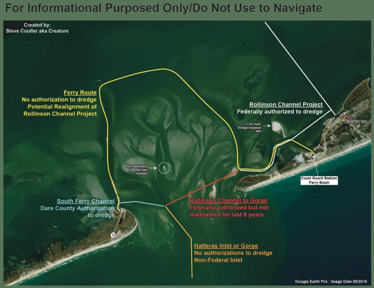
      After numerous complications with dredging the South Ferry Channel, the Army Corps of Engineers reported to the Dare County Waterways Commission at its Monday meeting that the hopper dredge Murden has finally started work removing the problem shoal.


      The federal authorization status of various areas in Hatteras Inlet, as compiled by Waterways Commission Chair Steve “Creature” Coulter.

      Dredging Underway at Hatteras Inlet
      Coastal Review Online

      Be the first to comment!


    Social Media Auto Publish Powered By : XYZScripts.com