Will Georgia’s Fledgling Oyster Industry Sink Before It Swims?
Our thanks to Ted Arisaka for sharing this link from Georgia Public Broadcasting.
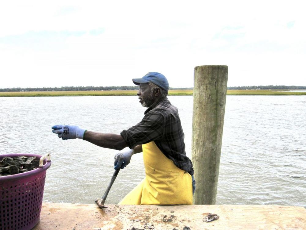
Will Georgia’s Fledgling Oyster Industry Sink Before It Swims?
GPB
Our thanks to Ted Arisaka for sharing this link from Georgia Public Broadcasting.
Will Georgia’s Fledgling Oyster Industry Sink Before It Swims?
GPB
Slate feeds marine creatures underwater, and the interaction enables divers to see large marine animals up close.


Bahamas Chatter is produced by Explorer Chartbooks, A CRUISERS NET PARTNER, which has long been the standard navigational supplement for enjoyable, informative, and safe cruising through the beautiful Bahamian waters and island visits.
Bahamas Chatter: Update COVID Exuma
Posted: 13 Nov 2020 06:46 AM PST
PRIME MINISTER STATEMENT ON EXUMA: INTRODUCED MEASURES TO REDUCE SPREAD OF COVID-19 IN EXUMA Prime Minister, Dr. Hubert Minnis announced the following restrictive measures for Exuma, effective Thursday, November 12:
1. There will be a 24-hour weekend curfew from 6pm Friday until 5am Mondays; businesses will not be allowed to operate during this time;
2. Weekday curfew will be from 6pm to 5am;
3. Commercial activity can continue through the week can continue save for fish frys, bars, and restaurants connected to bars;
4. Funerals are allowed at the graveside only and can have 10 people excluding the officiant; the same number of people is applicable to weddings – there will also be no repasts or receptions;
5. Church services are to be held virtually;6. Schools must be held virtually;
7. Effective tomorrow, domestic travel by air or sea is prohibited into and out of Exuma except in the case of emergency;
8. Anyone travelling from Exuma to any other island, must have a negative RT-PCR COVID-19 test;
9. No public or social gatherings are allowed.Dr. Minnis said these measures do not apply to the Exuma Cays.“I know this is short notice but this is essential after seeing what has happened on several past occasions,” he said.
The prime minister further explained that Exuma has recorded over 30 new cases in the past week.There are 79 positive cases from the island of Exuma – 28 are active, two are hospitalized and there has been one COVID-19 related death, according to Dr. Minnis. The prime minister also announced that the number of health care professionals on the island have been “boosted.”
“The measures on New Providence and Abaco have helped to decrease the spread of the virus on these islands,” the prime minister said earlier. “I assure you that we can continue to make progress if we continue to work together and wear our masks and avoid large gatherings.”He also said all positive cases are in isolation in Eleuthera and all contacts are being monitored.
My wife and I once spent a very pleasant three days in Elizabeth City waiting for the winds to drop allowing the long swing bridge to open. The 2.8-mile bridge across the Alligator River has closed several times in recent years to undergo repairs.
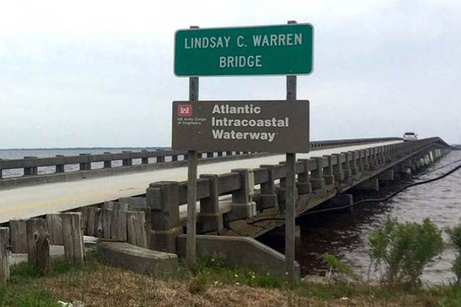
Lindsay C. Warren Bridge. Photo: Kill Devil Hills
Officials Push to Replace Alligator River Bridge
Coastal Review Online
Click Here To Open A Chart View Window, Zoomed To the Location of Alligator River Bridge
This excellent facility and CRUISERS NET SPONSOR, Southport Marina, was severely damaged by Isaias. See Hurricane Damage. As of November 6, they have resumed selling gasoline and diesel fuel.
We’re excited to announce that Southport Marina has resumed gasoline and diesel sales daily, from 8am-5pm. We are monitoring VHF ch. 16, phone 910-457-9900, and email info@southport-marina.com for any questions or needs. Although it will still be some time before we are able to accommodate overnight dockage for transiting guests, we would love to sell you the best quality marine fuel available while you’re in our town. Thank you for your patience while we continue to rebuild our facility! We’re looking forward to the opportunity to serve our customers again soon!
Hank Whitley, CMM
Marina Manager
Southport Marina
606 W. West St.
Southport, NC 28461
910-457-9900
View our live webcam at https://www.youtube.com/user/SouthportMarina
Click Here To View the North Carolina Cruisers Net Marina Directory Listing For Southport Marina
Click Here To Open A Chart View Window, Zoomed To the Location of Southport Marina
Our thanks to Phil and Karen for sharing their AGLCA Forum posting with our readers. Many of you will travel through Snows Cut at some point in your cruising lifetime. Mile long Snows Cut departs the coastal Waterway at the entrance to Carolina Beach and intersects Cape Fear River at Mile 296.
Living on the ICW, it’s amazing the number of boats we see every day heading south for the winter. 20, 30 a day perhaps, and we only see some of them. Trawlers, sailboats, large yachts and other craft, a few with looper flags but mostly snowbirds. Most loopers know Snow’s Cut, a few miles south of us, as a tricky waterway that connects the Cape Fear River with the ICW at Carolina Beach.
Though interesting, few good photos of this area exist. It’s difficult to get decent photos as you’re transiting it as you’re busy navigating a narrow, tricky channels with a 2 or 3 knot current. On a recent bike ride over the Snow’s Cut bridge, I took a few photos that might give our captains a good overview of the mile-long man-made cut.
Phil & Karen Barbalace
Helms Port
Wilmington,NC
Gold Loopers

Phil Kent and Karen Barbalace

Phil Kent and Karen Barbalace

Phil Kent and Karen Barbalace
Thanks for the great photos… Pictures are certainly worth a thousand words.
News you can use from NOAA Planet Stewards.

The Watch. News You Can Use From NOAA Planet Stewards – 3 November 2020
National Ocean Service, NOAA
Cruisers Net is proud to be a member of the Atlantic Intracoastal Waterway Association whose lobbying work is crucial to keeping the Waterway navigable. Your membership dollars directly support their vital work. Please join and encourage your boating neighbors to do likewise, regardless of their homeport.


| |||||||||||||||||||||||||||||||||||||||||||||||||||||||||||||||||||||||||||||||||
| |||||||||||||||||||||||||||||||||||||||||||||||||||||||||||||||||||||||||||||||||
|
Bahamas Chatter is produced by Explorer Chartbooks, A CRUISERS NET PARTNER, which has long been the standard navigational supplement for enjoyable, informative, and safe cruising through the beautiful Bahamian waters and island visits.
Bahamas Chatter: “New 9th edition Explorer Chartbook Near Bahamas” plus 1 more
| New 9th edition Explorer Chartbook Near Bahamas Posted: 02 Nov 2020 08:09 AM PST NEW 9TH EDITION EXPLORER CHARTBOOK NEAR BAHAMAS Lewis Offshore Ltd. is announcing the publication of the latest edition in the Explorer stable of chartbooks for the Bahamas: The EXPLORER CHARTBOOK NEAR BAHAMAS 9TH EDITION, which covers Biminis, Berrys, Abacos, Grand Bahamas, Andros and New Providence. There are 80 charts in the new book. All charts have been updated with variation on compass roses for 2020, plus much new hydrographic data. This revision includes four brand new charts:
Also, you will find the most recent Post-Dorian updates on the Abacos and Grand Bahama facilities and services. All Need-to-Know Info for each community has been updated, including many new cell phone numbers for local businesses. Land lines are still down in many areas hit by Hurricane Dorian. Tide Tables are updated for 2021-2022. The Table of Marinas (spreadsheet of current status of marinas) has been revised as well. Our new Print on Demand protocol will allow us to make more frequent changes in the future. ORDER ONLINE AT www.explorercharts.com. |
| Latest on Bahamas Entry Posted: 01 Nov 2020 04:30 PM PST The Islands of The Bahamas are currently open and looking forward to welcoming visitors from all countries. There are no restrictions on commercial international travel from any jurisdiction, nor are there restrictions on private planes or boats. It is recommended that all travellers interested in visiting The Bahamas review requirements applicable to each member of their party at Bahamas.com/travelupdates Those who booked travel under the former protocols that required an RT PCR test taken seven (7) days prior to travel will be permitted to enter The Bahamas with their Bahamas Health Travel Visa and negative COVID-19 RT-PCR test result, through November 6, 2020 only. Travellers planning to visit The Bahamas should also be prepared to:
Frequently Asked Questions as of 10.31.20 ENTRY REQUIREMENTS: TESTING, INSURANCE AND HEALTH VISA PRE-TRAVEL TESTING: Is a COVID-19 RT-PCR Negative (Swab) Test required to enter The Bahamas?
Is this also true for domestic inter-island travellers?
Where can I get a COVID-19 RT-PCR (swab) test prior to travel?
Can I use my Antigen or Antibody Test to enter the Country?
COVID HEALTH INSURANCE Does The Bahamas require separate COVID Health Insurance?
What is included as part of the COVID Health Insurance?
How much does the COVID Health Insurance cost?
HEALTH VISA Who needs to complete an electronic Bahamas Travel Health Visa?
Is a Health Visa required for domestic inter-island travellers?
Is there a fee for the Bahamas Travel Health Visa?
How do I upload my COVID-19 RT-PCR test results to my electronic Travel Health Visa?
When will I receive a response about my Bahamas Travel Health Visa?
Is a print version of my electronic Travel Health Visa required?
What if I do not complete the electronic Travel Health Visa application form?
How long are Health Visas valid for? Will visitors and residents be required to get a new Health Visa each time they travel?
POTENTIAL FOR CHANGES TO REQUIREMENTS What is the plan for the tourism industry should The Bahamas see a dramatic rise in cases?
Will persons wishing to travel from an island with a higher number of cases be permitted to enter an island with a low number of cases?
ARRIVAL PROCESS: TESTING PROCEDURES (AS OF NOVEMBER 1) INSURANCE, CONTACT TRACING AND RAPID ANTIBODY TESTS (NOV 14 AND LATER) Do I need to quarantine upon arrival in The Bahamas?
What are the updated travel and entry protocols?
· Prior to Travel: o COVID-19 RT-PCR Test: All persons travelling to The Bahamas must obtain a negative COVID-19 RT-PCR (swab) test taken no more than five (5) days prior to the date of arrival. The name and address of the lab, where the test was performed, must be clearly displayed on the test result. · Children age ten (10) and under, as well as pilots and crew of commercial airlines, who remain overnight in The Bahamas, are exempt from obtaining the RT-PCR test. o Travel Health Visa: Once in possession of a negative COVID-19 RT-PCR test, all travellers will then be required to apply for a Bahamas Travel Health Visa at travel.gov.bs (click on the International Tab) where the required test must be uploaded. · Beginning November 14, all visitors will be required to opt in to mandatory COVID-19 health insurance when applying for their Health Visa. o The insurance will cover travellers for the duration of their stay in The Bahamas. · A fee for the visa will be dependent on length of stay (ranging from $40-60 USD) and includes expenses for COVID Health Insurance and rapid antigen testing as appropriate. o Children age ten (10) and under will be covered at no extra charge and are exempt from taking a rapid antigen test. (more on visa pricing above) · Upon Arrival o Rapid COVID-19 Antigen Testing (if applicable): all persons who are staying in The Bahamas longer than four (4) nights and five (5) days will be required to take a rapid COVID-19 antigen test. · All visitors departing on or before five days will not be required to obtain this test. · The rapid tests are easy, quick and will yield results in 60 minutes or less with results being provided electronically via SMS text message and email. · Many hotel properties will provide relevant information on testing arrangements, while others will facilitate the required rapid test for their guests. · All persons on yachts and other pleasure craft will be able to make arrangements for their required rapid tests at the port of entry or via the relevant website. · All other visitors, returning residents and citizens – those staying or returning to private residences or rental properties such as Airbnb – will be able to make arrangements for their required rapid tests at the port of entry or via the relevant website. o Any visitor who exhibits COVID symptoms upon arrival or at any time during their stay will be required to take a Rapid Antigen Test and receive a negative result before being permitted to continue with their vacation. · If a person tests positive they will be required to follow up with a COVID-19 RT-PCR swab test. Who has to take a rapid antigen test?
Where can I make arrangements to take a rapid test if I’m staying longer than four (4) nights and five (5) days?
How much does the rapid test cost?
How long until rapid test results are ready?
What if I have a positive result on my rapid antigen test?
How will the Ministry combat the risk of asymptomatic persons?
ON ISLAND EXPERIENCE: TOURISM PROTOCOLS Restaurants, Businesses and Attractions Are on-island businesses, restaurants and attractions operating normally?
What are the requirements for travellers who are staying on an island that has curfew or lockdown measures in place?
What is the status of beaches?
When do I have to wear a face mask?
Do I have to wear a face mask at the beach?
What if I don’t wear a face mask?
What is the “Clean & Pristine” Certification?
What are the safety measures in place for front line staff and those that work in the tourism industry at all points of entry?
What does this mean for Taxis and Independent Cars?
What does this mean for Hotels, Resorts and Vacation Rentals?
What does this mean for Restaurants, Food & Beverage Services?
What does this mean for Excursions, Tours, Local Attractions and Shopping?
What does this mean for Vessel and Ferry Operations?
Check for updates at: file:///C:/Users/Basil/ |
Shelter Cove Harbour and Marina sits in the center of Hilton Head Island, South Carolina and the marina’s state-of-the-art facilities and comprehensive amenities are complemented by the lowcountry charm of the island.
*Due to COVID-19 protocols, Shelter Cove Harbour & Marina is taking extra precautionary measures to ensure the safety of guests and staff. Boats and equipment are being cleaned with soap and bleach at or above the CDC recommended mixing ratios. The marina Ship’s Store is regularly cleaned with disinfectants while focusing on key areas. Employees are regularly cleaning their hands with soap and hot water to keep them as well as customers safe.
Shelter Cove Harbour & Marina — Hilton Head Island, South Carolina

Hilton Head Island’s award-winning Shelter Cove Harbour & Marina, A CRUISERS NET SPONSOR, is the ideal place on Hilton Head for island fun, shopping and a bite to eat. Situated just off the Intracoastal Waterway — Latitude 32* 10’ 92” N Longitude 80* 43’ 56” W — in the middle of Hilton Head Island across from the renowned Palmetto Dunes Oceanfront Resort, Shelter Cove Harbour & Marina offers year-round waterfront dining, shopping and entertainment, along with water sports, activities and tours — all highlighted by Shelter Cove’s spectacular harbour and sunset views.

With 178 slip rentals, the Mediterranean-style Shelter Cove Harbour & Marina is Hilton Head Island’s largest deep-water marina. Shelter Cove’s state-of-the-art facilities and comprehensive amenities are complemented by the island’s Lowcountry charm. The skilled professional staff work hard to ensure that Shelter Cove maintains its stature as one of the East Coast’s premier boating destinations. Shelter Cove recently received the “South Carolina Clean Marina Certification.”

All kinds of water activities may be enjoyed here, from inshore and offshore fishing charters to sport crabbing, sailing and dolphin tours, sightseeing and nature excursions and more. One of the finest ports of call along the East Coast, Shelter Cove Harbour & Marina is your No. 1 Hilton Head Island destination.
When it comes to water adventure, Shelter Cove is the place to be. Rent a boat, kayak or paddleboard — or try out the popular two-person catamarans. Party-cyle with friends or fish for crabs, Shelter Cove has got it all, from nature & dolphin tours to dinner and fireworks cruises. There’s so much to do on the water at Shelter Cove. Inshore, nearshore and offshore fishing in Hilton Head Island provides some of the world’s ultimate fishing experiences.
Hilton Head is widely considered America’s favorite island, serving up 12 miles of pristine beaches and everything anyone needs for an ultimate coastal retreat. Hilton Head was voted “No. 1 Island in the Continental United States” for the fourth consecutive year in Travel + Leisure Magazine’s 2019 World’s Best Awards. In addition, readers of Condé Nast Traveler have voted Hilton Head Island 2019’s “Best Island in the United States” for the third year in a row.

Hilton Head Island’s weather is ideal for those wanting to explore the outdoors and soak up the sunshine. The Lowcountry region features a mild, subtropical climate all year round. Enjoy easy days relaxing in the sun, sand and surf on some of the best beaches in the country. Hilton Head offers a laid-back and welcoming vibe that makes it a perfect vacation destination. There’s something marvelously different about the warm and welcoming feeling found on Hilton Head Island.
Shelter Cove Harbour & Marina is one of Hilton Head’s most popular attractions, because it hosts impressive local and world-traveled boats and yachts, has many fine restaurants and shops, and is the site of some of the island’s signature annual festivals. These events include HarbourFest, an annual summer-long celebration known for its fabulous fireworks displays on select Tuesday nights from mid-June to mid-August.
**ALL 2020 EVENTS ARE SUBJECT TO CHANGE OR CANCELLATION DUE TO COVID-19 GUIDELINES AND CROWD RESTRICTIONS DETERMINED BY THE TOWN OF HILTON HEAD ISLAND AND OUR SOUTH CAROLINA GOVERNOR. ** Visit ShelterCoveHarbourFest.com for current updates.
Centrally located on William Hilton Parkway (Route 278) East at Mile Marker 8, Shelter Cove’s mid-island location on Broad Creek also makes it a perfect launching spot for other island excursions. But with fireworks during HarbourFest all summer long, there’s no better place to have fun than Shelter Cove. For the weekend or the summer — for locals and visitors alike — there’s plenty to enjoy.

Palmetto Dunes Oceanfront Resort has been a favorite vacation destination for decades, providing one of the richest vacation experiences in the country with more award-winning activities than any other resort in the Southeast. Ranked the No. 1 family resort in the United States and Canada and one of the “Top 25 World’s Best Family Getaways” by Travel + Leisure magazine, Palmetto Dunes features activities and experiences for every member of the family. Visitors and guests can explore Shelter Cove Harbour & Marina, enjoy one of the 2,000-acre resort’s three award-winning championship golf courses, bike along the beach, or kayak the 11-mile inland lagoon system.
GOLF
Palmetto Dunes Oceanfront Resort is one of the premier golfing destinations in the Southeast. Each of the three superb layouts are distinctively different, yet challenging. The Arthur Hills Course at Palmetto Dunes, designed by famed golf course architect Arthur Hills, was built on a series of rolling dunes and was named the state’s 2009 Course of the Year. The scenic Robert Trent Jones Oceanfront Course, home to one of the most stunning oceanfront holes in the Southeast, was honored as the South Carolina Course of the Year in 2003 and is a “Certified Audubon Cooperative Sanctuary” for its commitment to providing a sanctuary for wildlife. The George Fazio Course, Hilton Head Island’s only par-70 layout, presents a challenge to any accomplished golfer: a series of long par 4’s guarded by bunkers and water hazards. Veteran golfers regard the Fazio course as Hilton Head Island’s true championship course.

TENNIS AND PICKLEBALL
Tennis lovers are able to book their ultimate tennis vacation at Palmetto Dunes Oceanfront Resort on Hilton Head Island, South Carolina, and enjoy tennis court time, lessons, clinics and more daily at the award-winning Palmetto Dunes Tennis & Pickleball Center. Palmetto Dunes offers 19 clay tennis courts, four of which are lighted for night play, and a beautifully well-stocked, 1,800-square-foot tennis pro shop — Hilton Head Island’s largest. Palmetto Dunes also offers 24 pickleball courts, all of which are lighted for night play. The Palmetto Dunes Tennis & Pickleball Center has been named the island’s top tennis resort.


OUTDOOR ADVENTURE
Guests may use their complimentary bike rental to explore miles of paved pathways beneath towering live oak trees and three miles of pristine beaches. Hilton Head Outfitters is available for bike rentals, canoes, kayaks, fishing and much more. Fishermen may select a fly rod or light tackle to go after large redfish, trout, bluefish, flounder and black drum. The calm waters of the 11-mile inland lagoon system that runs through Palmetto Dunes present countless opportunities for fishing, bird watching and enjoying the beauty of nature. Guided paddling trips led by trained interpretative naturalists provide an introduction to the habitat of herons, osprey, dolphins and fiddler crabs. Outfitters guides also provide kayak lessons for beginners, and more.

BIKING
Palmetto Dunes and the surrounding area of Hilton Head Island offer more than 50 miles of paved bike paths that are ideal for exploring. There is even an underpass for crossing busy Highway 278 to access Shelter Cove Harbour and Marina from the resort. Guests may rent bikes, accessories and more at Hilton Head Outfitters to explore the island and to cycle along the beach. Hilton Head Outfitters delivers bikes for free for guests staying at the resort – or anywhere on the island – making bike rentals easy and convenient.

THE PALMETTO DUNES BUGGY (seasonal)
Getting around Shelter Cove Harbour and Marina and Palmetto Dunes Resort is easy, thanks to the Palmetto Dunes Buggy. This free, on-demand service enables guests to skip the traffic and visit the beach, golf courses, Tennis & Pickleball Center, restaurants and shops at Shelter Cove Harbour from mid-April through September.
BEACH FUN
Palmetto Dunes features three miles of pristine beachfront, the ideal locale for surfing, boogie boarding, swimming, walking, lounging and collecting shells. The wide, sandy beaches that front the Atlantic Ocean were reinforced using tons of sand dredged from the resort’s 11-mile lagoon system and Shelter Cove Marina. The sand was positioned to form the resort’s characteristic dunes.

DINING
From Shelter Cove Harbour & Marina, guests can bike — or take the free Dunes Buggy shuttle from April through September — to the Dunes House, a laid-back beach bar and restaurant where guests enjoy food, drinks and fun with spectacular views of the Atlantic Ocean. Big Jim’s BBQ, Burgers and Pizza at the Robert Trent Jones clubhouse is popular for a cold drink and relaxing meal. For more upscale dining, Alexander’s Restaurant & Wine Bar is located in Palmetto Dunes, at 76 Queens Folly Road. Alexander’s is an upscale seafood restaurant and wine bar, featuring seasonally inspired cuisine, locally caught seafood and many locally-sourced ingredients. The menu pays tribute to many classic Lowcountry and Alexander’s favorites such as Baked Flounder Imperial, Shrimp and Grits, and Wiener Schnitzel.

ENTERTAINMENT
For over thirty years, Shelter Cove Harbour has hosted HarbourFest, one of Hilton Head Island’s most popular entertainment events, from Memorial Day through Labor Day. HarbourFest features fireworks on select Tuesday nights as well as street vendors, musicians, arts and crafts and more. Popular troubadour Shannon Tanner presents seasonal entertainment at Shelter Cove with his beanie hat and trademark blend of original music, popular ballads and kid favorites. Plus, many restaurants at Shelter Cove Harbour offer live music seven nights a week all summer long. HarbourFest is free and open to the public.

KIDS’ ACTIVITIES
Palmetto Dunes packs more excitement into a day than most children can handle. From three miles of beach to biking, fishing, canoeing, boating, sport crabbing, exploring, nature tours, water skiing, surfing, paddle boarding or kayaking, kids love visiting Palmetto Dunes.

#
Click Here To Open A Chart View Window Zoomed To the Location of Shelter Cove Harbour and Marina

The North Carolina Estuarium in Washington, A CRUISERS NET SPONSOR, is exploring an essential element — water — with the Water/Ways traveling exhibition, a part of Smithsonian’s Museum on Main Street program.
Estuarium Dives into the Necessity of Water
Coastal Review Online

At the intersection of the Atlantic Intracoastal Waterway and the Okeechobee Waterway, Martin County, A CRUISERS NET SPONSOR, is a hub of boating activity and of events of interest to boaters.

|
|
|
|
|
|
|
|
|
|
|
|
|


Be the first to comment!