North/south Hwy 17, or Ocean Hwy, passes to the east of Hertford and is crossed by a fixed vertical clearance bridge between Ferry Point and Crow Point. If you have local knowledge re the vertical clearance of this bridge or have recently navigated this area, please let us hear from you.
Just wondered if anyone has been through the Highway 17 bridge in Hertford, N.C. lately? Is there a signboard with actual clearance to water level on it? I know the posted clearance to MHW is 33 feet, and my “air draft” is 32.3′, so I would want to make sure I know the real clearance before going through. Thanks. David Swanson
Explorer Chartbooks, A CRUISERS NET PARTNER, has long been the standard navigational supplement for enjoyable, informative, and safe cruising through the beautiful Bahamian waters and island visits.
Bahamas Chatter: New Fuel and Dockage Survey 7/2/19
A new fuel and Dockage Survey has been posted on https://www.explorercharts.com/index.php?option=com_content&view=article&id=56&Itemid=53 Since the last survey eight marinas raised their dockage prices and two marinas lowered them. Most fuel prices were up as well. The prices shown in red are old and should not be trusted. We will attempt to contact the marinas with old prices and if we cannot, they will be removed from the list.
The restaurant at Nassau Harbour Club has reopened after being closed for many years. The completely renovated restaurant is now called Lattitudes.
Roosevelt Nixon at Little Farmers Cay Yacht Club has announced a new laundromat is now open.
With a fixed vertical clearance of 65ft, Hwy 278 Bridge, called Skull Creek Bridge locally, crosses the Skull Creek portion of the Waterway. Our thanks to Blades Robinson for this notice.
Both tide boards were missing. We tried to report this to the toll free number shown on the bridge and the phone line was disconnected. We ended up backing up through the bridge due to current flow and cleared with no issue. Blades Robinson
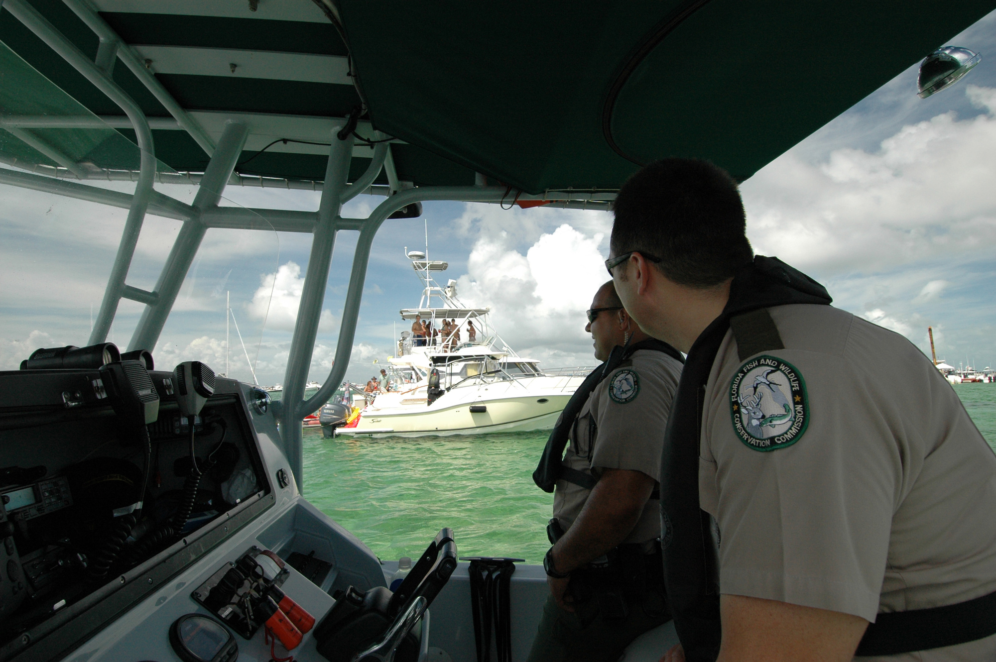
More words of wisdom from the Florida Fish and Wildlife Commission.
FWC promotes safe, sober boating this weekend for Operation Dry Water
The Florida Fish and Wildlife Conservation Commission (FWC) will be working to keep waterways safe this weekend.
During the national Operation Dry Water campaign officers will focus on removing impaired operators from the water and educating boaters about safety.
The Fourth of July holiday is one of the busiest boating holidays all over the U.S., including here in Florida. There are over 950,000 boats registered in the state and an estimated 1 million additional non-registered boats enjoying Florida’s waters.
Boaters should know that operating a vessel under the influence of alcohol or drugs is illegal and can lead to serious injuries and consequences. In Florida, it is illegal to operate a vessel with a blood alcohol content level of .08 or higher – the same as it is to operate a vehicle.
“As law enforcement, it is our job to do all we can to ensure the safety of our recreational boaters and paddlers,” said Maj. Robert Rowe, FWC’s Boating and Waterways Section Leader. “The accidents and tragedies that happen because individuals choose to drive impaired, on land or on the water, are preventable. We’re joining other agencies across the country to keep boaters safe and prevent accidents related to BUI.”
If a person decides to take alcohol on their voyage, it is important to designate an operator who isn’t drinking alcohol and will remain sober to ensure everyone gets home safely. The FWC encourages boaters to enjoy the boating season to its full extent by boating sober, wearing a life jacket and taking a boating education course.
Although this guide is aimed primarily at RVers, many of you have access to land transportation when in port, so read and enjoy. Our thanks to Joey Miller of Jen Reviews for permitting Cruisers Net to share this information with you.
A number of waterfront communities offer fireworks displays over the 4th of July and graciously permit spectator boats to anchor nearby – always a great vantage point for viewing. However, please remember that the time immediately following the displays, is a very dangerous scenario when party boats are weighing anchor and departing. Your night vision is usually disrupted by the bright lights and alcohol is often involved. The situation requires slow speed and sharp lookout. Please get back to your homeport alive!
As you fuel up this holiday weekend, keep an eye out for flame in any form on the fuel dock. As a longtime friend of Cruisers Net relates, dock hands are not exempt from safety guidelines. Do not hesitate to speak up!
I do not want to post publicly any unfavorable comment, but filled up at [ICW marina] in Georgia over the weekend and as I finished filling my gasoline tanks and put up the fuel hose the dock-master on site walked down on the gas docks, cigarette dangling from the mouth. It got MY attention.
Share:
Comments from Cruisers (1)
james- July 5, 2019 - 4:59 pm
Saw same thing at Fernandina Beach City Marina, staff hanging on the fuel pump while we filled up, cigarette in hand!!
Safe Harbor City Boatyard, formerly Charleston City Boatyard, a subsidiary of Safe Harbor Marinas, A CRUISERS NET SPONSOR, is found on the northern reaches of the Wando River north of red marker #40.
Our thanks to James Newsome of Save Georgia’s Anchorages for providing this list of contacts for your use in sending comments regarding this new legislation. For examples of recent comments, type Anchoring in the Search window of our Homepage.
6/28/19 Many people, both individually and with groups, are working behind the scenes to influence the final decision on anchoring in Georgia as a result of the draconian legislation that was passed by the General Assembly earlier this year. We need everyone’s help!!
@Coastal Resources Division – Georgia DNR
There’s just over 2 week left to submit your comments to GA Department of Natural Resources. Mail or email comments to: Kelly Hill, Coastal Resources Division, One Conservation Way, Brunswick, GA 31520. Kelly.Hill@dnr.ga.gov James Newsome and Jack White
Share:
Be the first to comment!
Jun 28, 2019by: Larry DorminyNo Comments27.37,-82.61839999
The Cape Coral Cruise Club is a group of dedicated cruisers who always provide unique reports from the marinas they visit. Longboat Key Club Moorings, A CRUISERS NET SPONSOR, is located on the western shores of Sarasota Bay, north of the city of Sarasota and south of Longboat Pass.
CCCC May Cruise to Sarasota
By Capt. Doug Rhees
Early in the year the CCCC cruise chairman made plans for the May Club cruise to take the Okeechobee Waterway, Caloosahatchee River, east to Lake Okeechobee, cross it and continue on east on the St. Lucie River to Stuart Fl. One of the Club members had made arrangements for 10 boats at Sunset Bay and Marina. As cruise time neared reports of shallow water east of Clewiston in the Lake had several members quite concerned about running aground.
This concern prompted a change in the May20 to 26 cruising dates as the safety of our members and their boats is paramount. We were able to obtain good dock space along with welcoming staff at both Marina Jack and Longboat Key Club in Sarasota. Because of the destination uncertainty and the late date change in venues, our numbers dwindled to just four boats. The trip up from Charlotte Harbor May 20 was pleasant as most boaters chose to run outside in the Gulf. The boat that came up the ICW found a pleasant ride as well with no bridge delays. Once all were docked Happy Hour was enjoyed by all at dockside.
Tuesday saw most members spending some time on boat projects prior to a group dinner at the Marina Jack upper level restaurant. Wednesday we all walked to the shopping area sightseeing and enjoyed a lunch at the Whole Foods store. We had an early group dinner at Owens Fish Camp (a local favorite and quite a unique spot). If you don’t get there early the wait can be very long.
Thursday we departed Marina Jack for a short 5 mile run up Sarasota Bay to the Long Boat Key Club to enjoy their pool and many amenities including the resort’s beach. Some of our group went via Marina shuttle to St. Armands Circle to shop. On day two the group spent time at the pool meeting new friends, and viewing the many large boats slipped at this beautiful facility. The evening meal was a group cookout using grills provided by the Marina.
As happens with most cruises the final day comes too soon and it was time to slip lines and shove off for home. Although some planned to head south on the outside for a faster return time, reports of an increasing south wind kept everyone in the ICW. It was crowded and slower but made for a safe ride home. Even a small group can and did have a great time. Hopefully a run to the east coast will be in the works for 2020.
The Cape Coral Cruise Club is open to new members who own a boat with overnight accommodations and
reside in the Cape Coral / Ft. Myers area. For membership information please contact Phil Kryger at
Derelicts have been and continue to be a major concern all along the Atlantic and Gulf coasts. If you have had experience with these derelict removal grants, let us hear from you, especially if you applied as an individual through a government agency.
Derelict Vessel Removal Grant 2018-2019 4th Opportunity Announcement 06/25/2019 The Florida Fish and Wildlife Conservation Commission (FWC) is announcing the opportunity for State, County, Municipal and other authorized governmental entities, to apply for Derelict Vessel Removal Grants. The Fourth application period for the Bulk Derelict Vessel Removal Grant Program will begin on Monday July 1, 2019, at 8:00 AM (EST), and end on Wednesday August 14, 2019, at 5:00 PM (EST). Applications received after Wednesday August 14, 2019, will not be eligible for consideration in round four. All removal applications must demonstrate proof that due process was provided for each vessel’s owner. At a minimum, this would include an opportunity for the vessel owner to challenge the derelict vessel determination, either in criminal court or in an administrative hearing. Vessel cases not demonstrating that these opportunities have been offered to the owners of the vessels will not be considered for state funding assistance. A letter of Authorization for Removal from the law enforcement officer must also be included for each vessel applied for. Should funding be available for a fifth or subsequent round of applications, new announcements will be made. The grant guidelines and application form may be downloaded at: http://www.MyFWC.com/DVGrant.
You may also receive the guidelines and application by contacting Phil Horning at (850) 617-9540 or email DVGrant@MyFWC.com.
Applications that meet the requirements for the Rapid Removal Grant Program may be submitted at any time after the opportunity announcement start date, but no later than November 1, 2019, at 5:00pm (EST) (based on available funding). Rapid removal cases must meet requirements of published guidelines as well as due process requirements. Total funding allocated for derelict vessel removal for fiscal year 2018-2019 is $1,000,000. The balance remaining will be available for additional DV removal grant opportunities in the 2018-2019 budget year. Applications may be mailed to the Florida Fish and Wildlife Conservation Commission, Boating and Waterways Section, Derelict Vessel Grant Program Administrator, at 620 S. Meridian Street – Room 235, Tallahassee, Florida 32399-1600 or emailed to DVGrant@MyFWC.com.
For further information, please contact:
Phil Horning, Derelict Vessel Program Administrator, Florida Fish and Wildlife Conservation Commission, Division of Law Enforcement, Boating and Waterways Section, (850) 617-9540 or email Phil.Horning@MyFWC.com
Our thanks to Jim Standing for this report of a recent group voyage to the Albemarle Loop, A CRUISERS NET SPONSOR, in Albemarle Sound. Along the way they encountered two more of Cruisers Net’s finest sponsors, Dismal Swamp Welcome Center and Albemarle Plantation Marina. The Albemarle Loop is also home to historic Edenton, another CRUISERS NET SPONSOR.


Be the first to comment!