CRUISERS NET
Cruisers Helping Cruisers
Comprehensive cruising resource for the Intracoastal Waterways
from Norfolk to the Northern Gulf and Bahamas.
from Norfolk to the Northern Gulf and Bahamas.
FREE to use due to the generosity of our sponsors - please patronize them
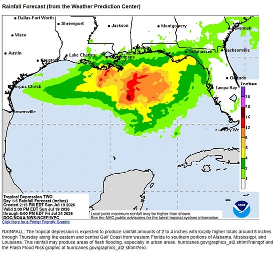
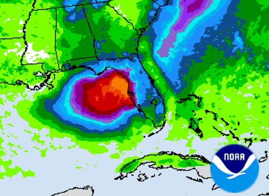
TD Two has formed over the Northeast Gulf – Fred Pickhardt
Fred Pickhardt’s Substack is free today. But if you enjoyed this post, you can tell Fred Pickhardt’s Substack that their writing is valuable by pledging a future subscription. You won’t be charged unless they enable payments.
Forwarded this email? Subscribe here for moreTropical Depression Two, has formed in the northeastern Gulf of Mexico with initial maximum sustained winds of 25 knots and a minimum central pressure of 1011 mb.
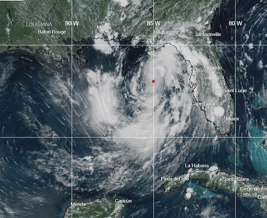
Current Status
- Location: 28.0N, 85.3W (Northeastern Gulf of Mexico)
- Current Movement: North-northwest at 3 knots
- Initial Intensity: 25 knots (30 mph)
- Minimum Pressure: 1011 mb
Expected Track and Timing
TD 2 is forecast to drift very slowly northwest, approaching the Florida Panhandle Monday and Tuesday before turning more towards the west.
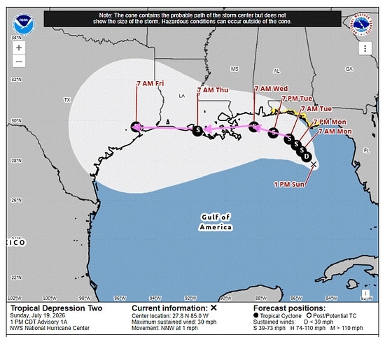
Wind Intensity Forecast
TD 2 should slowly strengthen reaching tropical storm intensity in about 24 hours peaking near 50 knots midweek. Rapid intensification is not likely due to dry air and wind shear.
Primary Hazards and Warnings
- Wind: A Tropical Storm Watch is active for parts of the Florida Panhandle.
- Flooding: Heavy rainfall threatens flash flooding through Thursday along the eastern and central Gulf Coast, spanning from western Florida into southern Alabama, Mississippi, and Louisiana.
Latest NHC advisories: NOAA NHC
You’re currently a free subscriber to Fred Pickhardt’s Substack. For the full experience, upgrade your subscription.


© 2026 Fred Pickhardt
548 Market Street PMB 72296, San Francisco, CA 94104Be the first to comment!
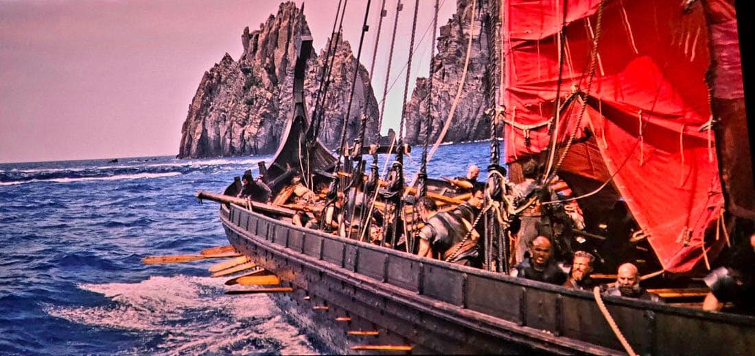
Draken Shows Off Her Star Power in ‘Odyssey’ – Loose Cannon
Cruisers Net publishes Loose Cannon articles with Captain Swanson’s permission in hopes that mariners with saltwater in their veins will subscribe. $7 per month or $56 for the year; you may cancel at any time.


 Forwarded this email? Subscribe here for more
When all else fails, try journalism.
Draken Shows Off Her Star Power in ‘Odyssey’
Per the Naysayers, Nothing Is Quite Right, Yet Somehow Magnificent


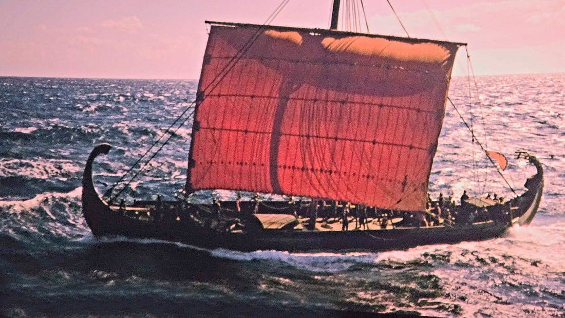
Starring as Odysseus’ flagship, Draken sails along, looking all Bronze Age Greekie without her dragon’s head stem. Last month, Loose Cannon poked fun at the folks moaning about a black woman playing the role of Helen of Troy in the movie “Odysseus.” These folks had obviously been hoping for someone more like Nicole Kidman. “The poet Homer may have been blind, but that doesn’t mean he was colorblind,” I wrote in jest.
Last night, we attended the film’s opening at our local theater, and I can testify that 1. The movie was breathtaking, and 2. Black Helen (Lupita Nyong’o) was a minor character with only a few minutes of screen time that hardly mattered.
Whereas Odysseus’ ship was a major character, she being the vehicle that transported these Trojan War veterans from one nightmarish disaster to another. (Forgive the trivialization, but the movie harkened back to cruising the New England coast in my old wooden sloop, during which we faced “a crisis in every port” of engine failures and near sinkings.)
The Bronze Age penteconter was played by Draken, a replica of a 10th century Viking longboat. As I jokingly pointed out, this choice was more a-historical than a black Helen. The Vikings built lapstrake hulls, while the Greeks stuck with carvel planking. Truth be told, the distinction was hardly noticeable on screen, and I shall return to Draken’s performance shortly.
But First
Predictably, a few of my own readers last month fell into the “I like white” camp, not from racism but a nerdy devotion to Homer’s sacred text. I rarely debate readers anymore. I have become convinced that you should be able to have your say without an author feeling he or she has to nitpick back at you. But this time I felt these grown-up prep-school grads had entirely missed the point.

‘Odyssey’ Movie Anachronism: That Viking Longship Ain’t Right
·Jun 8Read full story As I explained to one skeptic, the Odyssey is really akin to a fairy tale, albeit an epic one. Fairy tales are stories where wolves and pigs can talk and witches are real.
The narrator began last night’s movie by telling us that the events of the Odyssey happened “in a time of magic.” That plays out as you watch scenes of goddess Athena walking among us, a one-eyed giant, a witch or two, monsters and deadly sweet-singing mermaids.
But, no. Helen’s got to be milky white—Irish looking, if possible.
Let me go into some background about Helen that was not included in Homer, but would have been known to everyone listening in his audience: Helen was hatched from an egg.
Yeah, Zeus yearned for a little lovin’ from a human woman named Leda, who happened to be queen of Sparta, so he came down to court the lady the way one does. He took on the form of an oversized swan, swept down from the sky and raped her. (The New Testament God took a more nuanced approach when he sent the Holy Spirit in the form of a dove to impregnate Mary—via her ear in one telling.)
William Butler Yeats described the rape in his poem “Leda and the Swan,”¹ which begins:
A sudden blow: the great wings beating still
Above the staggering girl, her thighs caressed
By the dark webs, her nape caught in his bill,
He holds her helpless breast upon his breast.

So, in this 1920s depiction by Tadé Styka, Zeus is black and Leda appears to be disturbingly willing. So, with dad being a bird and all, Leda was unable operate her gestation machinery in the conventional way. Instead, she laid a clutch of eggs, one of which housed embryonic Helen. Pray tell, amigos mios, what color should a person be who was hatched from a friggin’ egg?
In a July 16 article for Slate, writer Myke Cole described the same phenomenon, except from the point of view of military history buffs who were fussing over Director Christoper Nolan’s choice of costumes, armament and fighting tactics:
Nolan didn’t care. He’s making a movie about a myth, not a YouTube video about military history. In selecting the Odyssey, he is clearly focused on rendering one of humanity’s great stories relevant for the widest audience possible, not with gratifying the niche concerns of purist military historians like me, a vanishingly small fraction of viewers. In the screaming over historical inaccuracy, these critics reveal the truth—the loneliness that nerdy obsessives like us feel when we are forced to confront the fact that most folks don’t care about minutiae like we do.
Which brings us back to the boat, as we must do, to fulfill Loose Cannon’s mission statement. Draken was simply magnificent, even as an anachronism in Hellenic disguise.
Beach scenes depicted Odysseus and crew running for their lives back to their ship, clambering on board and rowing away chaotically from pursuing Cyclops or the Laestrygonian cannibals. It occurred to me that scenes such as these must have played out thousands of times during the Viking Era, but with Saxons and Franks instead of giants.
Having just lost a bank of oars from scrapping along rocks, the ship heads toward the whirlpool known as Charybdis, to be followed by an attack from the monster Scilla of the six heads. Rock and a hard place. As fierce as they are portrayed, Norse raiders were also casualty-averse. They had to be, and the reason was simple. Each amphibious band had to maintain a certain number of hands in order to operate the ship—60 or 80 men to row, for example. They developed tactics and technology for the quick get-away, rather than risk too many casualties.
On a rocky shore, Vikings would drill a hole into a boulder, a hole big enough to loosely nest an iron mooring pin. These pins were likely fabricated with a big eye on top. Think: closed-loop oarlock. They would secure the bow of the longship to the pin with a long line, while deploying a stern anchor to secure the boat perpendicular to shore—barely afloat or barely grounded.
When pressed to escape a larger force, men on the bow could whip the line vigourously, flipping the mooring pin out of its hole, thus freeing the bow, as men aft hauled in the stern line, quickly moving the ship into deep water, while oarsmen took station.
For decades hopeful amateur archaeologists scoured the shores of New England, whereupon finding any hole in rock, would declare this as evidence of a Viking visit.
I will stop now, lest I be confused with a “lonely, nerdy obsessive.”
LOOSE CANNON covers hard news, technical issues and nautical history. Sometimes he tries to be funny. Subscribe for free to support the work. If you’ve been reading for a while—and you like it—consider upgrading to paid.
1In its entirety, “Leda and the Swan”:
By William Butler Yeats
A sudden blow: the great wings beating still
Above the staggering girl, her thighs caressed
By the dark webs, her nape caught in his bill,
He holds her helpless breast upon his breast.
How can those terrified vague fingers push
The feathered glory from her loosening thighs?
And how can body, laid in that white rush,
But feel the strange heart beating where it lies?
A shudder in the loins engenders there The broken wall, the burning roof and tower And Agamemnon dead. Being so caught up, So mastered by the brute blood of the air, Did she put on his knowledge with his power Before the indifferent beak could let her drop?Be the first to comment!
DOING WHAT EVERYONE EXPECTED – Janice Anne Wheeler, Sparring With Mother Nature
 Forwarded this email? Subscribe here for more
This is a different piece of history, my own. I was ready for a change of pace this week. Enjoy the mountains, for a change. ~J
If you just dove into our very engaging little community, please read SPARS & SPARRING, .….it introduces my wonders and my wanders. ~J

Listen to post · 9:28 I was raised in and around the public, protected lands of the United States. Our homes were within the 6,000,000 acre Adirondack Park in Upstate New York; National Parks far and wide were always our destinations. We ogled the Grand Canyon with our grandparents, camped in National Forests, explored Wilderness Areas, climbed Monuments in Utah, saw vast tracts of California, wandered seashores of the Southeast, always appreciating the unique and often endangered creatures each contains.
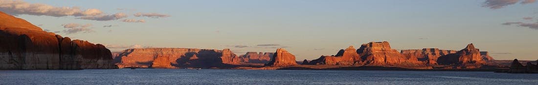
Utah sunrise. Lake Powell, Glen Canyon National Recreation Area. Author. My father achieved his Doctorate in education, but throughout his life told us he should have been a Forest Ranger instead. Less money, more life. He did what was expected of him, a high-ranking job in education, or at least that’s how I look at it now that I can no longer ask him.

US Geological Survey, each color is a level of Protected Public Lands. I feel fortunate that my home country has set these places aside. What follows must be one of the first stories I ever wrote and kept, perhaps two dozen years ago and in the third person, which I rarely use now. Predictably, it’s about a National Park and is presented here largely un-edited. I stumbled across a print copy and typed it in as a powerful reminisce of my transformational summer job three dozen years ago…. hard to believe it’s been that long. ~J
THE DECISION
She had repacked the car, taken her last exam, filled the gas tank, had the oil changed. It was late, early morning, in fact, when she pulled up to her boyfriend’s house to say goodbye. His sciatic nerve had acted up and he could not move from the bed. It was an awkward, weird conversation. He thought she was making a ridiculous mistake and told her as much. They parted, she knowing it was for the last time but not saying that out loud.
After leaving him she sat at the curb, both hands on the steering wheel, making sure she was ready. It wasn’t her first solo road trip, all those to and from Arizona were longer, but this one takes her far from everything she has known. The ivy covered walls loomed above the residence as they are supposed to at these old, renowned colleges. She had spent the winter of her Junior year interviewing with Corporate Recruiters, just as her classmates had, receiving an offer from Hilton and Marriott for a Summer Internship in big hotels in big cities, all expenses paid. Great resumé material; it’s what her counselor recommended she do. In fact, it’s what everyone recommended she do, and what everyone expected her to do.
But back in March, she had come across an unlabeled folder in the placement office that contained a flimsy three-fold brochure. The pictures were fantastic, too good to be true, she thought as she dialed the number. An elderly gentleman on the other end of the phone seemed surprised that she had found him, took her information and mailed her an uncomplicated two-page application which she promptly returned, applying to be a bartender, her favorite, most lucrative job in the industry. No high heels, no nylons or business suits, no internship to write about, no rotation through the various departments of some anonymous hotel. Probably not great resumé material. Her friends told her she was crazy, throwing her career away, putting herself another year farther from making the big bucks. Big, big, big. Big business, big careers, big hotels with thousands of rooms, dozens of restaurants and hundreds of employees. Big decisions, or so they seemed at the time.
She put the car in gear and drove west; the toll booths were lit but empty. Exhausted from making a decision no one agreed with, she pulled over at dawn somewhere on New York’s Southern Tier Expressway until an officer rapped on the window. Suddenly wide awake and ready to get gone, she continued the 2,700 mile, thirty-five hour drive, spending the night in Fargo, North Dakota. One gentleman at a gas station commented that he had never seen a car like hers before; it was an aging Mazda RX-7 and she was rendered speechless. She smiled at him, thinking of her classmates at Cornell. “Where in the hell is Glacier National Park?” they had asked her incredulously when she turned down the internships.
At the Montana border she still had hundreds of miles to go, and the first exit, honestly, is called Home On The Range. She laughed out loud, stopped and photographed the sign; she was a tourist, after all. The sun was shining and she pulled over on State Route 200 for a bite of lunch. Tremendous Black Angus cattle grazed nearby and gentle breezes blew the prairie grasses just as they did in all the stories she had loved as a child. When she started the engine, it dawned on her that no vehicle had passed in either direction for the thirty minutes or so she had been eating and strolling. The speed limit was 75. That was a lot of miles between her and the next person in either direction. A lot of miles. If you ever want to feel small, go to Eastern Montana and pull over wherever you wish. It’s pretty much just you and God, no matter what form of religion you do or don’t believe in.
The tiny hotel in Great Falls was the least expensive place she had ever stayed in her twenty-one years of life and one of the cleanest; the phone, rotary dial. Nervous because tomorrow she was to meet the elderly gentleman who had answered her call, sleep was elusive.
May 25, 1990 dawned clear and fabulous, a chilly frost lay on the car. Wondering if she had packed the right wardrobe, she headed Northwest. The longest and most colorful train she had ever seen was running along the north side of the narrow two-lane highway, and in the distance the Rockies appeared, white with winter snow. When those Burlington Northern cars crossed an overpass and framed the bottom of the mountain range, the tourist stopped. She would never forget that sight, and the enlarged photograph has been with her ever since.
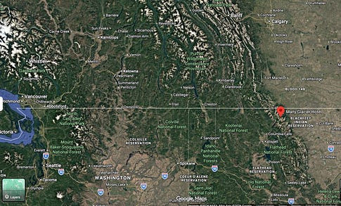
She entered the park at Babb, Montana, and headed up a thirteen-mile long dead end road, an hour and a half from any services except a tiny convenience store on the Blackfoot Reservation. She turned left into the hotel, crossed a bridge splashed by roaring rapids and surrounded by graying snowbanks. Many Glacier Hotel, with two hundred rooms, one place to eat and one place to drink took three years to construct in 1915 by The Great Northern Railway. Instead of bartending, she was in charge of the one place to eat, a football-field sized dining room serving 700 meals daily with fifty-five employees. None of that mattered. Her pay was $214 for a six-day work week, and that didn’t matter either.

Many Glacier Hotel is on the left side of the photo. Credit NPS. You see why it triggered my wanderlust. The restaurant manager’s room was in the “Crow’s Nest” above the atrium. Five flights up, her view and the one she remembered so well in the brochure matched perfectly. Swiftcurrent Lake was below, Grinnell Glacier to her left, fantastic peaks and valleys in every direction. The snow melted after a final blizzard brought snow in around the windows on June 11th. Grizzlies showed themselves every day, flowers bloomed, waterfalls ran.
It was, indeed, too good to be true. Not another doubt ever crossed her mind about that summer job decision. It wasn’t big. It was perfect.
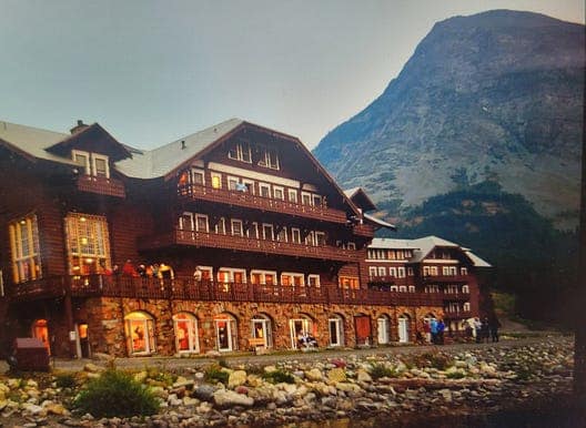
The left two windows in the main peak were my room. Heaven on earth. I remember being amazed how few people used the balconies. TripAdvisor 2018. All of the photographs I tell you about here are inaccessible right now, 35mm, print only, tucked into a storage unit as my old wooden sailing yacht rocks along in a life far, far different from the time I spent out West. After graduating from Cornell Hotel School, spring of ‘91, I became Beverage Manager at Yellowstone National Park’s flagship Lake Hotel, then moved to Colorado, spending twenty-six years there, Catering from a little organic farm on the stunning Western Slope after an I-just-have-to-make-sure-this-
is-not-for-me stint at a corporate skirts-required Hilton in the Denver Tech Center and a beloved adventure working Food and Beverage at Copper Mountain Resort where my skis hung in my office. If you have not experienced Glacier, as those familiar call it, GO. Drive Going To The Sun Road. Hike amongst the Beargrass. Watch the Mountain Goats play on vertical granite. GO. It’s officially Waterton-Glacier International Peace Park, a unique cooperation with Canadian National Park Waterton Lakes, which is stunning, too. GO. But don’t tell everyone!
What were you doing the summer of 1990? Or were you just a gleam?? ~J
If you believe other people will enjoy my stories, please take a quick sec to tap that heart and the little recycle symbol which sends these words out to the world somehow, which is how I get subscribers and fans. Even better, leave me your own reminisce! I answer every one and always enjoy the engagement. Thanks!
Share SPARRING WITH MOTHER NATURE
Someone asked me, “Why do you always take the harder road?”
And I replied, “What makes you think I see more than one road?”
—unknown—if you know, please lemme know. J
I so appreciate your support of my work. Have a wonderful week!


© 2026 Janice Anne Wheeler
Living aboard Sailing Yacht STEADFAST again soon!Be the first to comment!
Gulf Disturbance Update – Fred Pickhardt
Fred Pickhardt’s Substack is free today. But if you enjoyed this post, you can tell Fred Pickhardt’s Substack that their writing is valuable by pledging a future subscription. You won’t be charged unless they enable payments.
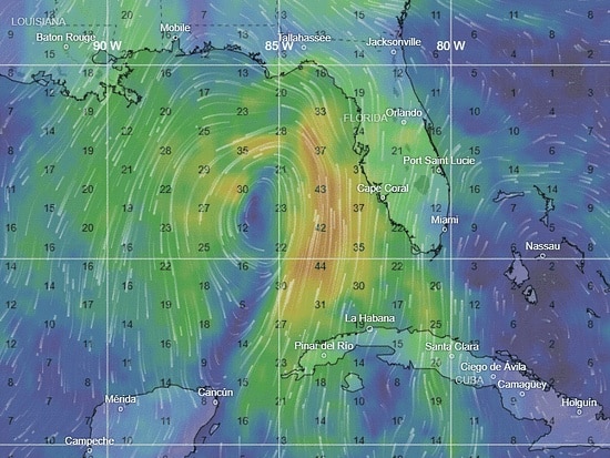
Forwarded this email? Subscribe here for moreUpper level low pressure across Florida and the far eastern Gulf now extends into the lower atmosphere, and a weak surface low.
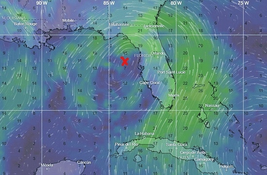
300 mb wind
This system has been designated a tropical disturbance (Invest AL91) by NOAA NHC. There is now a 40% chance for this system to become a tropical cyclone over the next 3-7 days as it moves slowly northward.
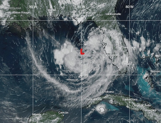
NOAA Satellite Image
Disorganized thunderstorms, strong wind gusts, and frequent lightning are occuring between 83W–84W and across the Florida Gulf Coast, mainly associated with an upper-level low. An Air Force reconnaissance flight scheduled for Sunday, July 19 to investigate the system.
Latest NHC advisories: NOAA NHC
You’re currently a free subscriber to Fred Pickhardt’s Substack. For the full experience, upgrade your subscription.


© 2026 Fred Pickhardt
548 Market Street PMB 72296, San Francisco, CA 94104Be the first to comment!
Weather Alert – Watching the Gulf, More Severe Thunderstorms Possible, SCDNR
Watching the Gulf, More Severe Thunderstorms Possible 
Weather Alert – July 17, 2026
Watching the Gulf
Finally, we again have some signs of life in the Atlantic tropics. There are two areas of interest out there today. One is close to home, and the other is way out there over the eastern Atlantic.
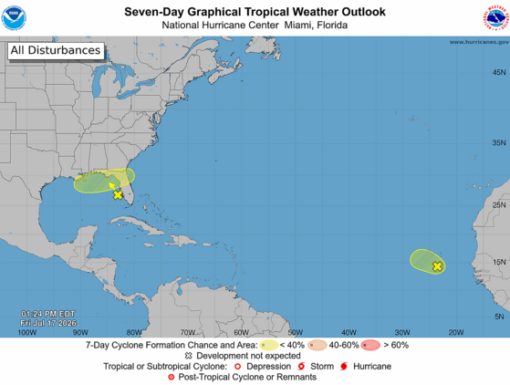
Here’s the National Hurricane Center’s (NHC’s) Seven Day Graphical Tropical Weather Outlook from Friday afternoon.
Our primary concern is a blob of thunderstorms that has erupted over the far western Gulf over the last 24 hours, associated with an upper-level low over the area. The area could (NHC gives it a 20 percent chance) evolve into a tropical cyclone as it wanders around the northeastern Gulf. Whether or not it becomes a tropical depression or storm, the most likely track will be over Florida and near the East Coast. The impacts will depend on the track and how strong of a feature it becomes, both of which are very uncertain right now. It could remain too far offshore to affect us, a disorganized plume of moisture that contributes to rain along our Coastal Plain early next week (ideal because we need the rain) or a tropical depression or weak tropical storm that brings our coastal areas heavy rain, gusty winds, a small storm surge along with a risk for isolated tornadoes. Another alternate scenario some of the computer models show is that it drifts westward instead and becomes more of a concern for the central Gulf Coast than for us. This feature will definitely have our attention over the weekend; if it will affect us, that will happen Monday night through Tuesday night.

The loop of visible satellite imagery above shows several features of interest across the North Atlantic and eastern U. S.:
- Thunderstorms are clustering around a developing low-pressure area over the northeastern Gulf.
- Low pressure along a tropical wave is centered near Cabo Verde and moving northeastward.
- A tropical wave is near 45° west, drifting westward slowly.
- Bands of smoke from large wildfires west of Hudson Bay can be seen from Michigan and Ohio through the Mid-Atlantic region and over the Atlantic north and northeast of Bermuda.
The other area of concern is over the eastern Atlantic, where a weak low-pressure area has formed along a tropical wave that recently emerged from Africa. It looks decent on satellite imagery with a swirl of clouds and some associated thunderstorms. However, it’s moving northwestward toward dry and stable air. So, it’s a long shot (10 percent chance, according to NHC) to become a tropical depression or a weak tropical storm while causing squally weather in Cabo Verde this weekend. After that, it likely remains a weak feature as it moves toward the central North Atlantic. It looks, to borrow a phrase from my favorite author, mostly harmless.
There are no other features of interest over the Atlantic today. A tropical wave is near 45° west over the middle of the tropical Atlantic, but it is very weak and unlikely to raise any ruckus in the coming days as it drifts westward.
Since there’s a small chance we’ll have to deal with a tropical storm next week, you’ll want to use the weekend to make sure your hurricane kits are properly stocked. As always, hurricane.sc is the place to go for prep advice.
More Severe Thunderstorms Possible
Another weekend, another cold front: our late week heat will ease through Sunday as another cold front moves in. We’ll see sparse coverage of routine afternoon thunderstorms this afternoon and Saturday afternoon, though keep in mind that sometimes our summertime storms become severe with isolated damaging wind. The Upstate has the best chance to see a severe storm.
By Sunday, the approaching cold front will be over our tomato-and-vinegar-loving northern neighbors, which will increase afternoon thunderstorm coverage over the northern half of our state and increase the severe storm risk in that area. Locally damaging winds will be the primary concern with the storms.
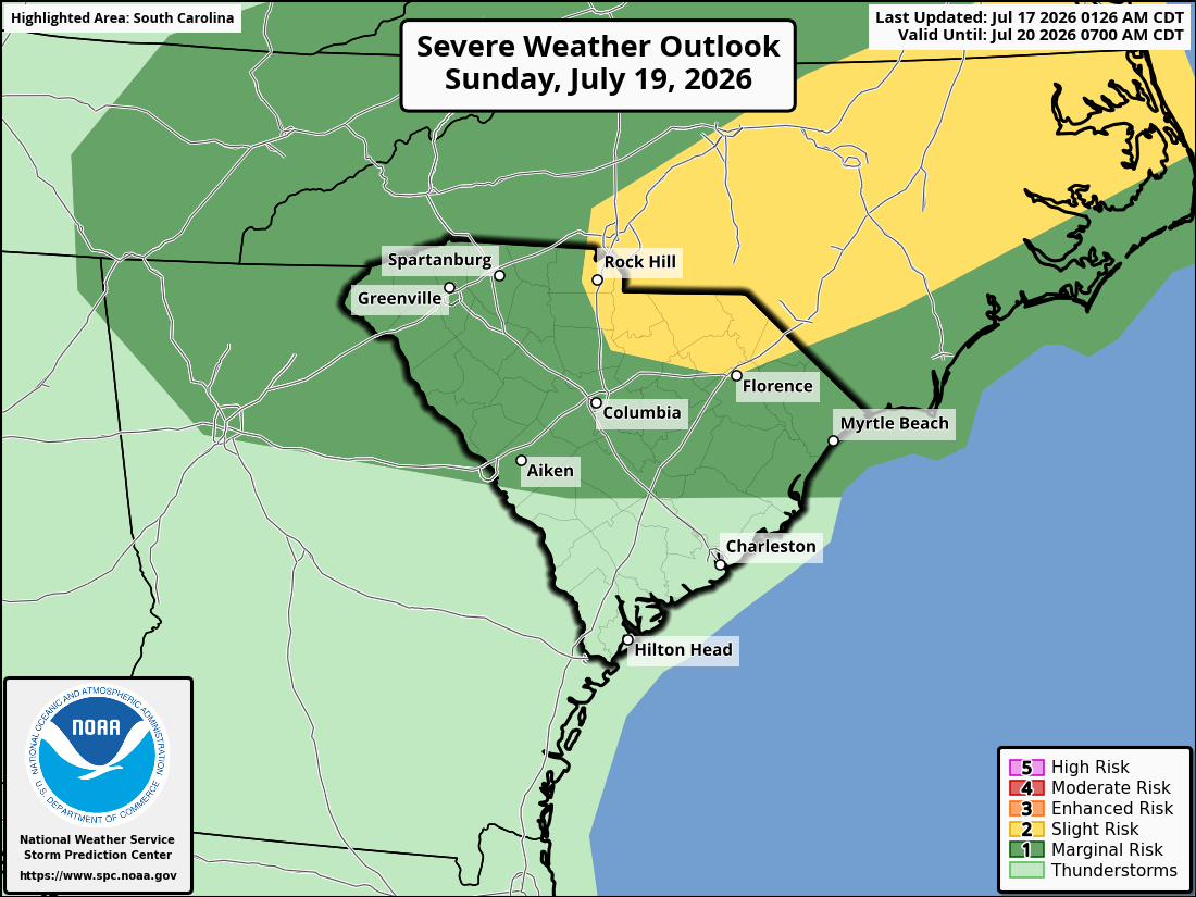
Here’s the Storm Prediction Center’s Day 3 Severe Weather Outlook for South Carolina, covering Sunday and Sunday night.
The front will become stationary and start to decay over us on Monday, so look for widespread showers and thunderstorms that could start to pop up before midday. Once again, a locally severe storm is possible. It will be the least hot day of the next few with highs only in the upper 80s and lower 90s.
Tuesday brings us less widespread thunderstorms and more heat; highs will be 90-95° across the state. However, the feature in the Gulf is the wild card for the day, as we’ll feel its impacts Monday night through Tuesday night if it tracks toward us. Our coastal areas are most likely to see it cooler and wetter; again, low-end wind, surge, rain and tornado risk is the worst-case scenario near our coast if the feature becomes a tropical cyclone.
On Wednesday, we have better-than-usual agreement among the computer models that another cold front will move in. The front is likely to bring showers and thunderstorms, and there is a chance of severe storms again if it moves through during the afternoon and evening.
We have a chance of unusually pleasant weather for at least part of the state later next week, as the weather pattern then will favor the cold front pushing much farther south than we typically see in July. Computer models tell us the front will stall to our south and east Thursday into Friday, allowing a drier air mass to move in with temperatures running near or slightly below average. 90° with low humidity is a pretty good deal for us in late July, so I’ll be rooting for that. However, climatology isn’t on our side, so don’t be surprised if the front stalls farther north and west than the models indicate, resulting in at least part of the state seeing scattered showers and thunderstorms. Of course, with most of the state still in a drought, more rain chances are a good deal, too.
On the satellite loop above, you’ll see areas of smoke from wildfires in Canada streaming by to our north. Some of it is sneaking into the Pee Dee; you may notice some haziness that way this afternoon. The smoke will mostly remain north of us through the weekend but it may shift southward toward us next week, especially later in the week.
Speaking of drought, if you have ever wondered how we define drought and its severity, I can tell you about an opportunity to learn more. The National Drought Mitigation Center (located at the University of Nebraska) will hold an online workshop to explain how the U.S. Drought Monitor works. If you’re interested, you can read more and sign up here: NDMC’s U. S. Drought Monitor 101 signup. The workshop will be held on August 13, from 3-4 p.m. Eastern Time.
Frank Strait
Severe Weather Liaison
S.C. State Climate Office


South Carolina Department of Natural Resources
260 D. Epting Lane
West Columbia, SC, 29172Stay Connected with SCDNR: 


SUBSCRIBER SERVICES:
Manage Subscriptions | Unsubscribe | HelpBe the first to comment!
Cruisers’ Net Weekly Newsletter – July 17, 2026
Cruisers’ Net Newsletter for this week has just been emailed via Constant Contact.
If you want to view the newsletter but are not signed up to receive them automatically, you can view it at https://conta.cc/44AG3Xj or see it below.
To automatically receive our emailed Fri Weekly Newsletter and Wed Fuel Report, click:Be the first to comment!
She May Have Already Been Sinking Before Anyone Noticed – Loose Cannon
Cruisers Net publishes Loose Cannon articles with Captain Swanson’s permission in hopes that mariners with saltwater in their veins will subscribe. $7 per month or $56 for the year; you may cancel at any time.
Forwarded this email? Subscribe here for more
When all else fails, try journalism.
She May Have Already Been Sinking Before Anyone Noticed
Marine Trader 50 Could Easily Handle 20 People. A Burst Hose, Not So Much


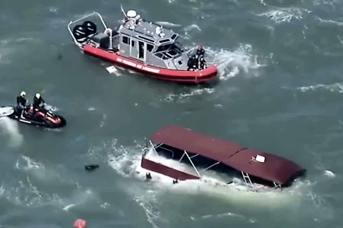
No, the Marine Trader that sank off Alcatraz was not overloaded with people. According to our go-to-expert on marine disasters, the 50-footer had almost surely been sinking long before anyone noticed. Then, at the critical point, she went under too quickly for anyone to make a Mayday call.
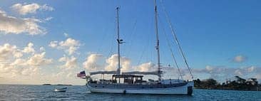
Of 20 on board, three people were lost in Tuesday’s sinking, plus a dog. Volare had been on a mission to scatter the ashes of a friend—a quick out-to-sea and back. This type of trawler yacht may not have been an ocean-crosser, but she was designed to easily handle normal sea conditions in San Francisco Bay, reported as four- to five-foot seas and Force 4-5 winds that day.
Roger Long is a retired naval architect who specialized in designing research vessels and sailing ships. He has testified in official proceedings about vessel stability in connection with disasters at sea. He helped Loose Cannon readers understand the sinkings of Bayesian and Pride of Baltimore.

The Complete Roger Long Stability Collection
·September 21, 2025Read full story Moreover, Long cruises the East Coast in a Gulfstar 43, a trawler of similar vintage and design as Volare.
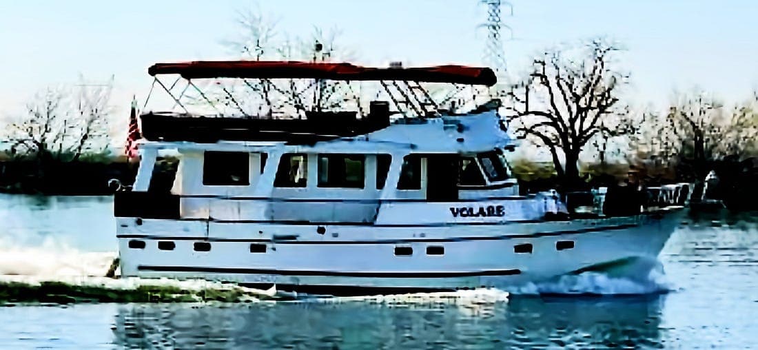
Volare underway in what appears to the California Delta inland waterways near her homeport of Stockton. Early news accounts inaccurately described her as a pontoon boat. Regular news accounts are rarely very helpful when the marine community is trying to figure out why a perfectly good boat decided to capsize or sink. Getting “slammed” by a five-foot wave, as the San Francisco Examiner reported, would not have been enough. John Arndt framed the real question, writing in the July 15 Latitude 38 online marine news outlet:
While many news reports did mention rough seas, they certainly weren’t any rougher than most sailors, wingfoilers and other boaters regularly experience while sailing San Francisco Bay. We are experiencing king tides, which could account for some additional chop, but realistically, it feels as if something unusual happened to cause this tragic accident. These were “normal” Bay conditions, so some other explanation is probably needed to understand why a solidly built 50-ft trawler somehow faltered on the Bay.
Long is fairly certain the explanation is “undetected engine room flooding.”
The Coast Guard reported that the boat was hit by a wave, causing it to suddenly capsize and throw people into the bay. Yet the images of the Bimini top just peeking over the water show Volare awash but upright. Then she sank.
According to Long, who has done the math, no matter how people on board were distributed during the reported sea conditions, their weight would not topple Volare onto her side, let alone sufficiently to submerge the boat’s engine intake vents.
Long said similar designs are licensed by the Coast Guard to carry up to 49 passengers.
An unusual design feature of the Marine Trader 50 is that each of her twin engines has its own stand-up engine compartment, separated by a corridor that leads from the main accommodations area to an aft cabin.
Long noted that a diesel engine will continue to run until water rises high enough to flood its air intake. In other words, a lot of water can come in before a stalled engine makes the problem apparent. According to Long, a possible culprit in the flooding was a burst raw-water cooling hose.
If the doors to the engine compartments were all closed, water coming into one side might create an asymmetrical flooding scenario, at least initially (and depending on how well the doors were sealed).
Retired Coast Guard Lt. Commander John Mixon, speaking to NBC News, speculated that the seeming rapidity of Volare’s sinking may have been due to “water intrusion in the lower levels of the boat.”

This track was provided to Latitude 38 by Greg Braswell. The vessel was barely two miles from getting back to her embarkation point at San Francisco when the accident happened, and the number of people and the social nature of the outing may have masked the fact that the boat was beginning to handle poorly, Long said.
A broker who once helped sell Volare was very familiar with her. After the disaster, he spoke to a witness. “I believe it was a mechanical failure in the port engine room, which was sealed. But the facts will come out,” Mike Garner said in a Facebook comment. “I say that because one of my close friends, who is a captain, was there and witnessed this tragic incident from the beginning to the end. What he described to me made sense.”
According to news accounts, the Coast Guard will investigate the feasibility of recovering Volare, which now sits on the bottom 128 feet down. Some number of the missing three bodies may be inside her.
LOOSE CANNON covers hard news, technical issues, and nautical history. Every so often, he tries to be funny. Subscribe for free to support the work. If you’ve been reading for a while—and you like it—consider upgrading to paid.
Be the first to comment!
Potential Eastern Gulf Tropical Development – Fred Pickhardt
Fred Pickhardt’s Substack is free today. But if you enjoyed this post, you can tell Fred Pickhardt’s Substack that their writing is valuable by pledging a future subscription. You won’t be charged unless they enable payments.
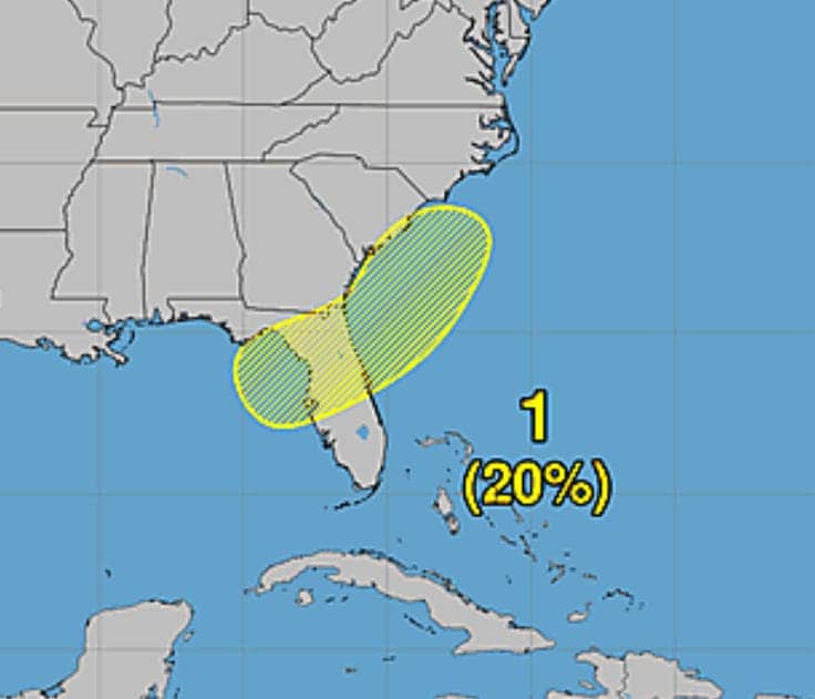
Forwarded this email? Subscribe here for moreAn upper-level low over western Cuba is expected to move northward over the eastern Gulf and Florida over the next several days.
300mb Forecast Friday July 17th
A weak surface trough or low center could form over the weekend producing heavy rainfall over the eastern Gulf and the west coast of Florida.
5 Day Precipitation Forecast through Monday
There is a slight (20%) risk that the surface low could develop into a subtropical or tropical depression.
Latest NHC advisories: NOAA NHC
Forensic Marine Weather Expert
You’re currently a free subscriber to Fred Pickhardt’s Substack. For the full experience, upgrade your subscription.


© 2026 Fred Pickhardt
548 Market Street PMB 72296, San Francisco, CA 94104Be the first to comment!
Back When Dumping a Little Petroleum Was a Righteous Small-Craft Storm Tactic – Loose Cannon
Cruisers Net publishes Loose Cannon articles with Captain Swanson’s permission in hopes that mariners with saltwater in their veins will subscribe. $7 per month or $56 for the year; you may cancel at any time.
Forwarded this email? Subscribe here for more
When all else fails, try journalism.
Back When Dumping a Little Petroleum Was a Righteous Small-Craft Storm Tactic
‘Storm Oil’ Isn’t a Thing Anymore, And Not Just Because It’s Illegal


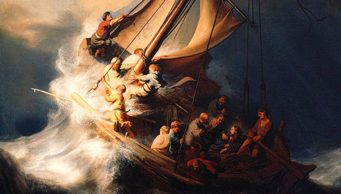
Christ in the Storm on the Sea of Galilee is a 1633 oil-on-canvas painting by the Dutch Golden Age painter Rembrandt. It was based a description of the Gospel of Mark about how Christ calmed the water. A rational thinker might surmise that Jesus—the only calm guy on the boat—had applied the old sailors’ trick of using “storm oil,” which helps prevent waves like this one from breaking. One scholar has suggested oil may also have played a role in preserving the vessel that ran into foul weather while carrying St. Paul to Rome. This story first appeared on July 26, 2023.
While writing a story recently about a harbor plagued by petroleum spills, I was reminded of being a kid and reading about mariners using oil to help survive offshore storms. It was the 1960s, so the magazine might have been in Yachting before it transmogrified into the sop to millionaires it is today.
“Storm oil,” they called it, and it could be deployed upwind in a container attached, for example, to a sea anchor, where it slowly released its contents. Like nutmeg on butternut squash, storm oil was effective even when applied in tiny amounts.
And, as the photo above was meant to suggest, the technique has been used since biblical times. As recreational boating was trending upward in the last century, boating magazines were launched to serve the new market, and one service to readers was to pass along wisdom of professional mariners.
One early magazine account of storm oil appeared in this issue of Motor Boating, known for it’s stunning cover art:
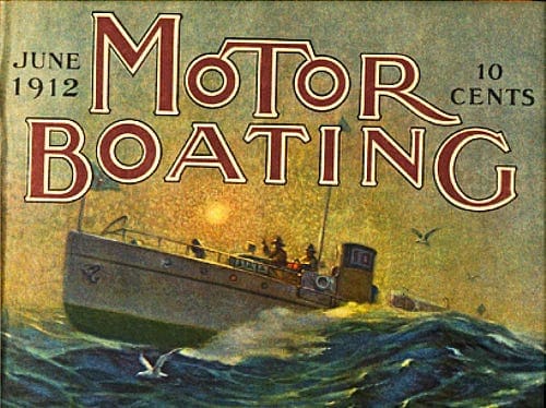
This “heavy weather edition” of the June 1912 magazine credited the Phonecians with first use of storm oil: Sailors from the ancient Middle Eastern nation had observed “that after passing through the wake of whales, oil exuding from their bodies left a perfectly calm spot” (presumably referring to the bodies of the whales, not the sailors).
The following bits of wisdom were contributed to Motor Boating by E.A. Crawford of Newark, N.J.:
As soon as the oil spreads on the surface of the water, it places a film over it, which effectually prevents the waves from coaming and breaking. Of course, it has no effect on the swell.
Three bags should be sufficient for a boat as they may be constructed in any manner desired, although the usual shape is cylindrical about six inches in diameter, of two or more thicknesses of heavy canvas. Stuff with oakum and punch full of holes at least a quarter of an inch in diameter to allow the oil to leak out, which is easily done with a marlin spike.
These holes also admit the water, so it can facilitate the oil leakage and make it more uniform. Saturate the oakum with lard oil, if obtainable, as experiments tend to favor it to all others. Still most any oil will serve in an emergency, although mineral oil, having little fatty matter will not produce as good result as vegetable oil, while lard oil being composed entirely of fat is most effective…
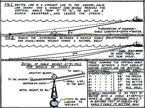
If riding to a sea anchor, bend them to the cable, so it will be several fathoms ahead of the boat. Running before the wind, tow one from each bow, using enough line on them so they will always be in the water. At anchor, make one fast to the cable several lengths ahead of the boat, allowing sufficient line so it will float freely.
Cone Can in a Sea Anchor
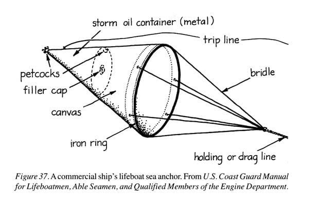
Lifeboats were required to carry them until 1998. Originally, fish oil was the preferred medium, and it was the cheapest. Wave-quelling oil could also be used when launching or recovering ship’s boats or embarking or disembarking a pilot. Attached to a Kellet
This illustration is from the June 1943 issue of Motor Boating. “Kellet” in the headline is a somewhat obscure term for a weight attached to an anchor rode. Storm Oil Bags
 The middle one, from an online market site, was labeled “no longer available.” The other two are in museums. (Click on an image to enlarge it.)
The final reference to storm oil that I could find in MotorBoating (the name had become one word) was a 1978 story about a 70-foot sailing vessel lying ahull. She was apparently surfing down massive waves and outrunning the slick until her crew began towing warps to slow the boat down enough to enjoy the effects of the oil.
Benjamin Franklin
There he goes again. Research a topic long enough, and sooner or later Benjamin Franklin is going to pop up. It wasn’t enough that he invented lightning rods, swim fins and bifocals, that he was first to chart the Gulf Stream, but it was Franklin that first confirmed scientifically the efficacy of storm oil.
LOOSE CANNON covers hard news, technical issues and nautical history. Sometimes he tries to be funny. Subscribe for free to support the work. If you’ve been reading for a while—and you like it—consider upgrading to paid.
Sailing to England in the 1860s, Franklin observed that the greasy galley discharge from a nearby ship smoothed its wake. After arriving he conducted experiments at a British lake, which he summarized in a report on “Stilling the waves,” writing:
“Not more than a tea spoonful produced an instant calm, over a space several yards square, which spread amazingly, and extended itself gradually till it reached the lee side, making all that quarter of the pond, perhaps half an acre, as smooth as a looking glass.”
This YouTube guy replicated Franklin’s approach and gives a pretty good explanation of the science involved. He even used olive oil, as likely had the early Phonecian practicioners.

 Ben Franklin Correspondence on Stilling …2.7MB ∙ PDF file
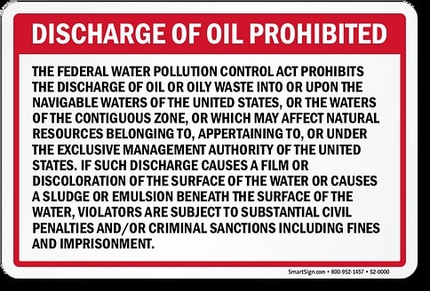
Download The Federal Water Pollution Control Act was enacted in 1948, but rewritten in 1972 and amended twice since. For boaters, one result was the placard below, which we are all required to display on vessels 26 feet and over with an enclosed engine compartment.
But what if a vessel is outside U.S. waters entirely? Todd Lochner, an admiralty lawyer in Annapolis, was asked whether restrictions on releasing oil follow us onto international waters, which is where we are most likely to have to ride out a storm.
The short version is that there are laws which are applicable to both U.S. territorial waters, and generally speaking, there are laws which will follow the flag state of the vessel. Let’s not forget that there are certain treaties like UNCLOS¹ which will apply, particularly if the flag state is a signatory as well. As usual, clear as mud with a lawyer response that I need more information and factual scenario, etc. etc.
As late as 1991, “Chapman Piloting & Seamanship & Small Boat Handling” was still informing readers of the benefits of oil in the storm but with a disclaimer about it’s dubious legality. In 1999, the first edition of “Surviving the Storm: Coastal & Offshore Tactics” by Steve and Linda Dashew only mentions storm oil a few times in passing.
No matter, I think. If given a choice between adding a couple quarts of Rotella T to the Atlantic and death by drowning, most of us would probably choose the former. The law and politically correctness may be why none of our written authorities are touting oil as a solution nowadays, but the real reason for its disuse is this: We now have tools to avoid being caught in storms, which did not exist before the 1990s, let alone 1912.
Better Forecasts
Ocean-crossers like the Dashews are a rare breed. Many of us haven’t done anything riskier than an overnighter. Most offshore passages are limited in duration to four, maybe five or six days. Think “I-65,” the route from New England to the Caribbean via Bermuda.
Weather forecasting for a four-day window is actually pretty damn accurate nowdays, and, since the new Millenium, the electronic means for receiving such forecasts have proliferated, the latest and greatest being Starlink. We’re not getting surprised like we used to.
Think of this way: The conditions for using storm oil and a sea anchor are pretty much the same, as suggested by one of the illustrations above. Yet the sea anchor has become like a vestigial tail. Many of us still carry one, but most of us who do, have never used it.
If you’ve deployed a sea anchor in actual storm conditions, please share the story with us below. Do you think oil would have helped?
LOOSE CANNON covers hard news, technical issues and nautical history. Sometimes he tries to be funny. Subscribe for free to support the work. If you’ve been reading for a while—and you like it—consider upgrading to paid.
Be the first to comment!
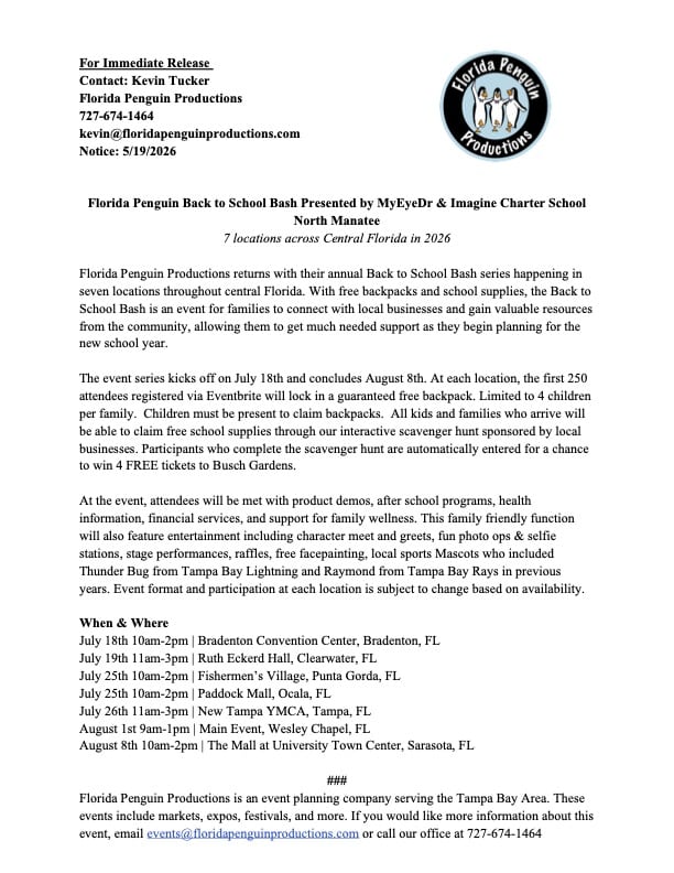
Fishermen’s Village Back to School Bash, July 25 10am – Fishermen’s Village, Punta Gorda, FL

There is always plenty to do around Charlotte Harbor. While berthed at Fishermen’s Village Marina, A CRUISERS NET SPONSOR, you are certain to enjoy visiting Western Florida’s beautiful Charlotte Harbor/Peace River.


Special Events & Community Relations941.639.8721
Click Here To View the Western Florida Cruisers Net Marina Directory Listing For Fishermen’s Village
Click Here To Open A Chart View Window Zoomed To the Location of Fishermen’s Village
Be the first to comment!
Summer’s Sweetest Week Starts Here – Elizabeth City
Elizabeth City sits at the southern terminus of the Dismal Swamp Canal and has the well-earned reputation of being a transient-friendly town with free dockage for 72 hours.

https://visitelizabethcity.com/
Be the first to comment!
How Bad will El Nino be? – Fred Pickhardt
Fred Pickhardt’s Substack is free today. But if you enjoyed this post, you can tell Fred Pickhardt’s Substack that their writing is valuable by pledging a future subscription. You won’t be charged unless they enable payments.
Forwarded this email? Subscribe here for moreBoth the US CFSv2 and the ECMWF ENSO models agree that this El Niño is strengthening rapidly and will likely be a strong-to-very-strong event peaking in fall/winter 2026.
The ECMWF is forecasting a peak relative Niño 3.4 anomaly of roughly 3.0–3.7°C, while CFSv2 peaks around 2.0–2.2°C. That’s nearly a full degree difference at the high end, with both models using the same relative index framework. The CFSv2 projection shows signs of a waning El Niño by early 2027, while ECMWF holds near peak conditions. If we average the two models you get a peak of about 2.7 C which would be a very strong El Nino indeed.


Putting this in historical context using RONI:
Since February 2026, NOAA’s Climate Prediction Center has used the Relative Oceanic Niño Index (RONI) as its official ENSO metric, replacing the traditional ONI. RONI subtracts the tropical-mean SST anomaly from the Niño 3.4 value and applies a scaling factor, stripping out background warming to isolate true El Niño intensity. The three strongest events in the instrumental record (1950–present):

No event in the historical record has exceeded 2.5°C RONI. ECMWF’s plume implies a serious chance of shattering that ceiling by 0.5–1.2°C, which would be genuinely unprecedented. Even CFSv2’s more conservative projection would place this event among the top three on record, approaching the 1982-83 peak.
The 2015-16 event for comparison:
The 2015-16 El Niño crossed 1.0°C RONI in June 2015 and accelerated through fall: JAS 1.6 → ASO 1.9 → SON 2.2 → OND 2.3 → NDJ 2.4 (peak). Decay was swift, dropping below zero by May 2016 and plunging into strong La Niña (−1.1°C) by fall.
The 1982-83 event followed a nearly identical trajectory, peaking at 2.5°C in NDJ–DJF before collapsing into La Niña by late 1983.
Notably, the traditional ONI ranking of these events is different: 2015-16 led at 2.6°C, followed by 1997-98 at 2.3°C, and 1982-83 at 2.2°C. RONI reverses that order, revealing that much of 2015-16’s apparent record strength was inflated by background tropical warming rather than El Niño dynamics alone.
What to watch:
As we move into late summer, the rate of intensification will tell us which model is closer to reality. If we’re tracking toward ECMWF’s upper range, this will be an event unlike anything in the modern record. If CFSv2 is right, it’s still a major El Niño with significant global weather impacts, but not the record-breaker ECMWF suggests.
Forensic Marine Weather Expert
You’re currently a free subscriber to Fred Pickhardt’s Substack. For the full experience, upgrade your subscription.
Be the first to comment!


Social Media Auto Publish Powered By : XYZScripts.com
Be the first to comment!