Cruisers Net is proud to be a member of the Atlantic Intracoastal Waterway Association, whose lobbying work is crucial to keeping the Waterway navigable and safe. Your membership dollars directly support their vital work. Please join and encourage your boating neighbors to do the same, regardless of their home port.
Early Registration Ends Today, October 19th
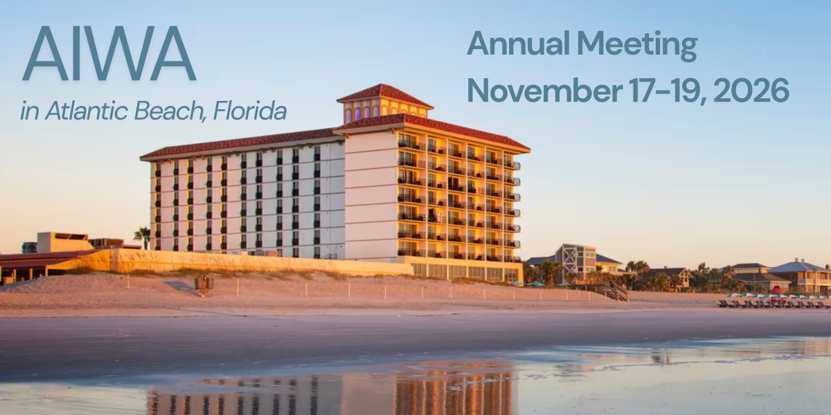
The AIWA Annual Meeting is one month away! Join us to learn from distinguished speakers in the industry, and network with fellow waterway stakeholders.
We look forward to welcoming you to Atlantic Beach, FL next month!
Brad Pickel, Executive Director Atlantic Intracoastal Waterway Association
Members Notice On November 18, 2026, the association will vote on a recommended change to the bylaws language related to the number of possible board members in Article 5, Section 3 as outlined below:
The current language: Section 3. At the Annual Meeting there shall be elected by ballot the Chair, Vice Chair, Treasurer and Secretary. The Board of Directors shall consist of no more than 15 members. At each Annual Meeting, one-half (or, one half plus one in the event of an odd number) of the Directors shall be elected for a term of two (2) years. Any Director shall be eligible for re-election provided they are representing members in good standing, or who are members in good standing themselves. Directors shall, upon election, immediately enter upon the performance of their duties and shall continue in office until their successors shall be duly elected and qualified unless they resign, are removed, or are otherwise unable to fulfill an unexpired term.
The proposed language: Section 3. At the Annual Meeting there shall be elected by ballot the Chair, Vice Chair, Treasurer and Secretary. The Board of Directors shall consist of no more than 17 members. At each Annual Meeting, one-half (or, one half plus one in the event of an odd number) of the Directors shall be elected for a term of two (2) years. Any Director shall be eligible for re-election provided they are representing members in good standing, or who are members in good standing themselves. Directors shall, upon election, immediately enter upon the performance of their duties and shall continue in office until their successors shall be duly elected and qualified unless they resign, are removed, or are otherwise unable to fulfill an unexpired term.
The AIWA is a national non-profit organization with the mission of securing funding and support for the maintenance of the Atlantic Intracoastal Waterway. We are the only organization dedicated to ensuring the future of the AIWW and proudly represent all stakeholders of the waterway.
Fred Pickhardt’s Substack is free today. But if you enjoyed this post, you can tell Fred Pickhardt’s Substack that their writing is valuable by pledging a future subscription. You won’t be charged unless they enable payments.
November brings a massive relief to Gulf mariners as tropical threats plunge—but it also ushers in a notorious structural hazard: the “Norther.” As late autumn settles across the US Gulf Coast, routing strategies completely shift from avoiding hurricanes to surviving punishing cross-sea conditions.
Whether you are hugging the Texas coastline or making a crossing toward the Yucatan, here is what you need to know about routing, sea states, and the arrival of the classic Gulf cold front.
Gulf Port Weather
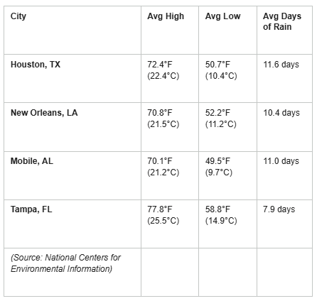
Coastal cities stretch across the region with relatively consistent rainfall (averaging 8 to 12 days of rain) and daytime highs resting comfortably in the 70s F (23-25 C).
Weather at Sea
Temperature
Temperatures remain favorable for autumn sailing, with a noticeable warming as you travel south:
Northernmost Gulf: Air temperatures (red contours) average near 20°C (68°F) along the coastal waters, with sea surface temperatures (green contours) around 22-24°C (72-75°F).
Southern Gulf & Yucatan Channel: Air temperatures are warmer at a balmy 25-26°C (77-79°F), accompanied by sea surface temperatures of 26-27°C (79-81°F).
Source: PUB 106: Atlas of Pilot Charts North Atlantic Ocean (November)
Unlock the rest of this post, including our actionable checklists and complete data breakdown, by joining our community of paid subscribers today. …
Keep reading with a 7-day free trial
Subscribe to Fred Pickhardt’s Substack to keep reading this post and get 7 days of free access to the full post archives.
If you haven’t heard the news, Michael Hodges, SCORE’s fearless leader, will be retiring from the program after 24 and a half years of service!
Michaels commitment to grassroots oyster restoration has always centered on fostering a sense of ownership for our natural resources. Under his tenure SCORE has educated more than 26,500 people about the importance of oysters and salt marsh resiliency through outreach efforts. Through boots-on-the-ground work and plenty of sweat equity SCORE has involved almost 67,000 volunteers totaling 144,436 stewardship hours.
Building on the foundation that Nancy Hadley laid starting in 2000, Michael has met challenges with innovation, embraced the power of volunteerism, and through the partnerships and new funding sources has scaled the SCORE program from a small grassroots restoration program to the beast it is today.
Michaels commitment to SC’s oyster resources and love for the salt marsh has aways been contagious. he has mentored many current and former SCDNR staff and left his mark not only at DNR, but on the national living shoreline stage. Today SCORE is the largest state oyster shell recycling and restoration program in the country, and many other agencies, nonprofits, and groups have applied what SCORE and Michael have created in South Carolina to their home fisheries.
Thank you, Michael, for always believing in your people and giving us the freedom to think outside the box. The estuaries will be a little less bestuary without you.
If you’re interested in helping celebrate his retirement, please reach out the score@dnr.sc.gov
New Volunteer Software
Curious on how our new volunteer software works? Watch our quick demo here
SCDNR is proud to introduce our new volunteer management platform, Galaxy Digital!
No need to fill out your volunteer information every time you come out and volunteer with us. Simply create your volunteer account once, and you’ll never have to create another account again.
Galaxy Digital will be your one-stop shop for everything SCDNR volunteer-related. You’ll be able to sign up for individual volunteer opportunities, sign up your team, view your total volunteer hours, and more!
Roast season is here! Please remember to recycle your oyster shell and to roast responsibly.
Roasting responsibly means making sure the oyster shell from your oyster roast ends up in a recycling bin so it can be used to replant South Carolinas oyster beds. This also means recycling only oyster shells and to remove trash before you recycle. Click on the link to find a recycling bin near you!
The SCORE team had a busy summer and couldn’t have done it without the help of volunteer power. This 2026 reef season we completed 11,684 linear feet of shoreline! This accounts for 2.4 acres of oyster reef added to the South Carolina coast. Thanks to 3,500 volunteer field hours in addition to the numerous hours in the fall and spring to make the substrate that we put out in the summer.
Kiawah
The SCORE team along with partners, Sustainability Institute and Conservancy of the Sea Islands, completed our Kiawah Bridge Project! We successfully deployed 800 manufactured wire reef units (MWRs) at four sites encompassing the bridge. The installation of these MWRs accounted for over 2,000 feet of living shorelines! These MWRs will provide the substrate needed for larval oysters to attach to, grow, and provide the amazing ecosystem services we get from having healthy living shorelines. These ecosystem services include but are not limited to habitat, erosion mitigation, and water filtration. It was tough work done well by all stakeholders involved!
AMI
The SCORE team went out to AMI Kids Beaufort and put on an all things crabbing clinic for the boys out there. Staff members went over the life cycle, anatomy, and the rules and regulations surrounding Atlantic blue crabs (Callinectes sapidus). Staff members then taught them how to catch blue crabs with old fashioned hand lines as well as crab baskets. Several crabs were caught, then the boys were taught how to dispatch, clean, cook, and eat them. It was a great day of fellowship and understanding the resource right there on their campus!
Calling all Costal Cooks
Grand Strand Area:
Oyster shell recycling volunteers are needed! Great news is that Grand Strand restaurants are on board for shell recycling. We are seeking partners and volunteers interested in getting involved.
Please click the link for more information.
As a part of our joint SCORE/ SC SeaGrant Consortium’s Title 1 schools grant we will be developing a costal cookbook highlighting SC coastal cuisine and creating another connection between people and the salt marsh for participating students. Please be as detailed as possible and include a picture, ingredients necessary cookware, step by step instructions, and a fun recipe name. Also feel free to include any personal/family/historical anecdote about your dish. If your dish is included for inclusion, we will be sure to share a copy of the cookbook with you! Please send submissions to score@dnr.sc.gov
Spe-SHELL Announcements
Be on the lookout for Shellby in a Christmas parade around town!
Fred Pickhardt’s Substack is free today. But if you enjoyed this post, you can tell Fred Pickhardt’s Substack that their writing is valuable by pledging a future subscription. You won’t be charged unless they enable payments.
NOAA Climate Prediction Center (CPC) in their October updated ENSO Diagnostic discussion confirmed that the current El Niño has been intensifying into what could become a historic climate event. In their advisory, the CPC notes that reaching a 3-month temperature anomaly of +2.5°C or higher would exceed the strength of all previous major El Niño events dating back to 1950.
Keep reading with a 7-day free trial
Subscribe to Fred Pickhardt’s Substack to keep reading this post and get 7 days of free access to the full post archives.
Elizabeth City sits at the southern terminus of the Dismal Swamp Canal and has the well-earned reputation of being a transient-friendly town with free dockage for 72 hours.
Coast Guard vessels respond to the emergency after Grace Bailey’s mast broke off on October 9, 2023.
Kate McCann is a folksinger who plays banjo. She specializes in songs about the sea, and is studying ethnomusicology at a university in Newfoundland, that most maritime of Canadian provinces. When she was younger and living in Connecticut, she worked as “chanteyman” at Mystic Seaport and as a deckhand on sailing ships.
The question now before a federal court in Maine is whether McCann was a “seaman” under the Jones Act when the top part of schooner Grace Bailey’s mast broke and fell on her during October 2023.
Grace Bailey, wooden and built in 1882, was carrying passengers on a fall foliage tour of Penobscot Bay at the time of the accident. A witness said a spar landed on McCann’s lap.
“Plaintiff Katherine McCann was on the subject voyage in service of the schooner and acting in the scope and course of her employment as a musician/crewmember of that schooner,” her lawyers wrote in a lawsuit against Grace Bailey owners.
Earlier this month, two other federal suits were filed seeking compensation for injuries in the same accident, which injured a total of five people killed a local doctor. There were 25 passengers and seven crew on board, according to the Coast Guard.
According to McCann writing in her Substack newsletter, she had to spend four nights in a Maine hospital. She also wrote about having been selected as a finalist in a statewide song contest. And she said she planned to attend the awards show six weeks later “even if it means I have to be wheeled onto the stage!”
Katherine McCann in her element.
The Grace Bailey defense team will likely argue that McCann and her co-musicians of the band Skylark may have been entertaining passengers for pay, but as contractors, not crew. As such, they will say, McCann did not meet the criteria to qualify for legal benefits afforded under the Jones Act.
According to McCann’s suit, the fact that the top 25 percent of a 70-foot wooden mast broke off during moderate wind and seas was proof that Grace Bailey had been unseaworthy and that her owners were negligent for having failed to detect rot in the mast.
McCann’s lawyers said she is “entitled to maintenance at a reasonable daily rate and cure until she reaches the point of maximum medical improvement…together with interest, costs and legal fees.”
The Jones Act includes the ability for a successful plaintiff to slap a lien on the vessel itself, so McCann could end up owning Grace Bailey, at least theoretically.
The Report
In its November 21, 2024 investigation report, the U.S. Coast Guard issued nine safety recommendations calling for improved detection of internal wood decay, more rigorous mast inspections, updated testing methods, better crew training, preventive maintenance programs and more comprehensive recordkeeping. Investigators also urged unstepping wooden masts more frequently for inspection and greater cooperation with marine surveyors, sailing organizations and wood-science experts.
Coast Guard headquarters accepted or partially accepted most recommendations but declined broad industry collaboration and additional crew-training guidance, opting instead for limited reviews and potential updates to existing inspection policies.
For the wood-boat crowd, the report will read like porn, with its discussion of “non-destructive testing” and references to stress-wave scanning, resistance micro drilling and fungal identification. It also discussed the differences between sapwood and heartwood on a Douglas fir tree and the optimal growth rings per inch for mast use.
Rotten mast sections document by investigators.
The investigators described how passengers began hearing weird noises above them, but couldn’t see any signs of a problem. Then this:
At 10:12 a.m., a third noise reporting from aloft was recognized by multiple passengers and crewmembers. The captain and mate scanned the rig, finding the mainmast bending at a point approximately 75 percent up the mast. Without delay, the captain ordered everyone to get down. As he did, the mainmast collapsed, twisting, and falling to starboard.
Maureen Colvin of Massachusetts was another person, suing Grace Bailey owners. Her lawyers described Colvin’s experience:
Plaintiff was abruptly impacted from above by a sail and subsequently felt the weight of the mast. Plaintiff was propelled down approximately eight feet of stairs, resulting in a violent impact with the floor below.
According to the lawsuit, Colvin was holder of a captain’s license, and so she put the first-aid component of its requirements to good use. She went back up on deck and then.
Plaintiff administered medical care to passengers…Plaintiff discovered Dr. Emily Mecklenburg positioned awkwardly on the vessel with significant bleeding to her head. The plaintiff observed fellow passengers performing CPR on Dr. Mecklenburg, but she perceived that Dr. Mecklenburg was beyond recovery.
The third lawsuit, filed by Christopher and Diane Sarao, centers on his “serious injuries” and her “emotional distress and loss of consortium.”
This lawsuit stands out because it tells the story of a prolonged breakdown in vessel maintenance, inspection, repair and oversight. It reaches beyond the current owner to the people and businesses involved in the schooner’s condition over many years.
So were Tom Lokocz Adams and his company Maine Design, which performed a 2022 pre-purchase survey on the Grace Bailey. So were Raymond Williamson and Ann Williamson of Windjammer Cruises, which sold the boat to her current owners. So were Michael F. Rogers and his company Privateer Boatbuilding, which performed repair on Grace Bailey in 2014, and unspecified “2014 repair defendants.”
The captain of the vessel, Samuel J. Sikkema, was also named as a defendant.
Dr. Emily Mecklenburg.
LOOSE CANNON covers hard news, technical issues and nautical history. Sometimes he tries to be funny. Subscribe for free to support the work. If you’ve been reading for a while—and you like it—consider upgrading to paid.
Fred Pickhardt’s Substack is free today. But if you enjoyed this post, you can tell Fred Pickhardt’s Substack that their writing is valuable by pledging a future subscription. You won’t be charged unless they enable payments.
Mariners and boaters should excercise caution this weekend in the northern and western Gulf. A cold front is forecast to enter the northwest Gulf Friday afternoon or evening, and reach from southwest Florida to the central Bay of Campeche by late Saturday. Fresh to strong winds and moderate to rough seas will follow the front, with near gale to gale force winds likely over the west- central Gulf by Saturday morning, and over the SW Gulf by late Saturday.








 Roast season is here! Please remember to recycle your oyster shell and to roast responsibly.
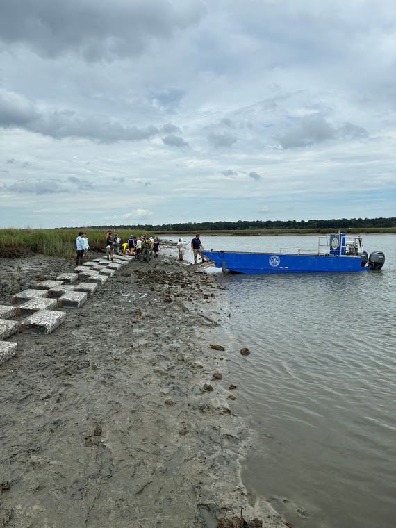 The SCORE team along with partners, Sustainability Institute and Conservancy of the Sea Islands, completed our Kiawah Bridge Project! We successfully deployed 800 manufactured wire reef units (MWRs) at four sites encompassing the bridge. The installation of these MWRs accounted for over 2,000 feet of living shorelines! These MWRs will provide the substrate needed for larval oysters to attach to, grow, and provide the amazing ecosystem services we get from having healthy living shorelines. These ecosystem services include but are not limited to habitat, erosion mitigation, and water filtration. It was tough work done well by all stakeholders involved!

 Be on the lookout for Shellby in a Christmas parade around town!






Be the first to comment!